
State Flags in the United States.
~~
Alaska
Alabama
Arizona
Arkansas
California
Colorado
Connecticut
Delaware
Florida
Georgia
Hawaii
Idaho
Illinois
Indiana
Iowa
Kansas
Kentucky
Louisiana
Maine
Maryland
Massachusetts
Michigan
Minnesota
Mississippi
Missouri
Montana
Nebraska
Nevada
New Jersey
New Hampshire
New Mexico
New York
North Carolina
North Dakota
Ohio
Oklahoma
Oregon
Pennsylvania
Rhode Island
South Carolina
South Dakota
Tennessee
Texas
Utah
Vermont
Virginia
Washington
West Virginia
Wisconsin
Wyoming

Alabama Gulf Coast.

Teton Valley Farm in Idaho by Kathy Alexander.

Quincy Smelter, Houghton, Michigan by Dave Alexander.

Manhattan skyline from Brooklyn, New York, by Carol Highsmith.
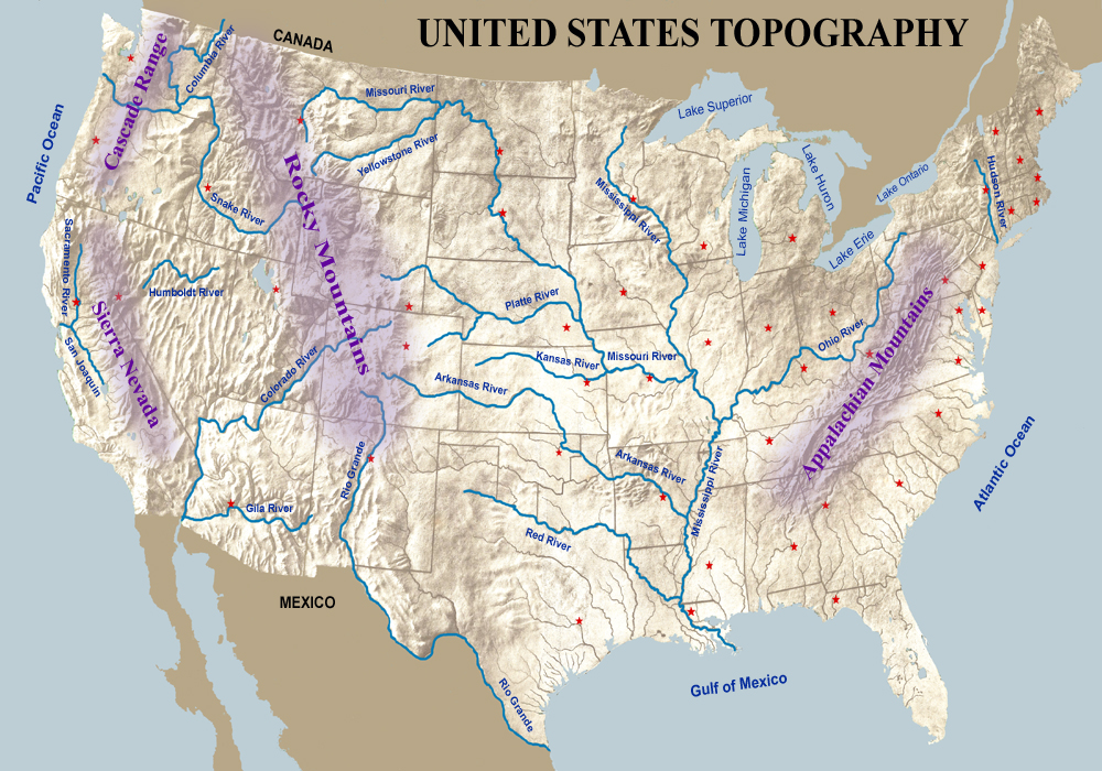
U.S. Topography. Click for 8.5 x 11 printing. Click HERE for mini-poster print.
The 50 states of the United States of America cover a vast land area of nearly 3.7 million acres, with a wide range of geographic features and nearly every type of global climate.
The contiguous 48 states share a border with Canada to the north and Mexico to the south. The Pacific Ocean bounds them on the west, the Atlantic Ocean on the east, and the Gulf of Mexico to the southeast. The contiguous United States is also known as the Lower 48. Alaska, included in the continental United States, is located at the northwestern end of North America. Hawaii lies far to the southwest of the mainland in the Pacific Ocean.
The United States also administers several territories, including five inhabited territories: American Samoa, Guam, the Northern Mariana Islands, Puerto Rico, the U.S. Virgin Islands, and several others.
The United States began with the 13 original states and then grew as people pushed westward, and the boundaries were modified as territories and states were added.
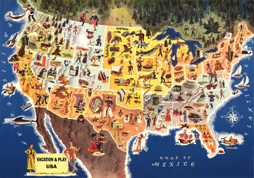
Vacation & Play Map. Click map for 8.5 x 11 printing. Click HERE for mini-poster print.
Washington, D.C., the capital city, is a federal district on land donated by the state of Maryland.
More than twice the size of the European Union, the United States provides various landscapes, including tropical beaches in Florida, high peaks in the Rocky Mountains, vast central plains, barren deserts in the West, and dense wilderness areas in the Northeast and Northwest. Interspersed throughout our country are the Great Lakes, the mighty Mississippi River, impressive formations in Yellowstone and Yosemite National Parks, more mountain ranges such as the Appalachians and the Sierra Nevadas, and lakes and rivers by the hundreds. The lowest point in the country is in Death Valley, California, at 282 feet below sea level, and the highest peak is Denali (Mt. McKinley) in Alaska at 20,320 feet. Across the nation, residents and visitors also enjoy National Monuments and Historic Sites that display more dramatic landscapes, various eras of American History, historic buildings, and more.
“I haven’t been everywhere, but it’s on my list.” – Susan Sontag

State Capitals in the United States. Click map for 8.5 x 11 printing. Click HERE for mini-poster print.
Also See:
United States Facts, Trivia, & Firsts
See Sources.

Bucket List for each State. Click for 8.5 x 11 print version. Click HERE for mini-poster print.