Geography of the United States is an important tool for learning and understanding American History. It has affected history as the country was first explored and settled, the government changed, wars were fought, and the nation expanded westward. In addition, environmental changes brought droughts and floods, causing migrations of people from one place to another.
Yet America is a poem in our eyes; its ample geography dazzles the imagination, and it will not wait long for metres.
— Ralph Waldo Emerson
Bucket List Attraction in Each State
Scenic Byways & Historic Trails
The United States Flag – History & Facts
United States Fast Facts:
Official Name: United States of America
Capital: Washington, D.C.
Population: 330,472,944 (Pre 2020 Census)
Area: 3,531,905 square miles.
Official Language: None, but most of the country is English-speaking.
Currency: US Dollar.
Form of Government: Federal republic and a constitutional representative democracy.
National Symbols: Bald Eagle, the American bison, Colors – red, white, and blue, National Anthem – Star-Spangled Banner

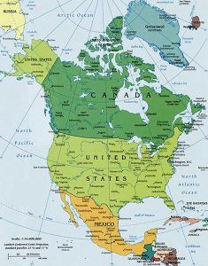
North America Map courtesy World Atlas.
Geography has made us neighbors. History has made us friends. Economics has made us partners, and necessity has made us allies. Those whom God has so joined together, let no man put asunder.
— John F. Kennedy
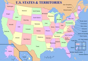
Today, the United States is the world’s third-largest country in size and nearly the third-largest in population. Located in North America, the country is bordered on the west by the Pacific Ocean and to the east by the Atlantic Ocean. Along the northern border is Canada and the southern border is Mexico. There are 50 states and the District of Columbia. It also has five territories including Puerto Rico, the U.S. Virgin Islands, American Samoa, Northern Mariana Islands, and Guam.
More than twice the size of the European Union, the United States has high mountains in the West and a vast central plain. The lowest point in the country is in Death Valley, California, which is 282 feet below sea level, and the highest peak is Denali (Mt. McKinley) in Alaska at 20,320 feet.
Compiled and edited by Kathy Alexander/Legends of America, updated January 2023.
Also See:
Sources:
Central Intelligence Agency
Kids National Geographic
Wikipedia


