
Taos, New Mexico Pueblo, by Kathy Alexander
Several historic pueblos are scattered throughout the American Southwest, some dating back centuries. These pre-Columbian towns and villages were often located in defensive positions on high mesas, cliffs, and canyons.
Cochiti Pueblo, New Mexico
Isleta Pueblo, New Mexico
Jemez Pueblo, New Mexico
Kewa Pueblo, New Mexico
Laguna Pueblo, New Mexico
Nambe Pueblo, New Mexico
Ohkay Owingeh Pueblo, New Mexico
Picuris Pueblo, New Mexico
Pojoaque Pueblo, New Mexico
Sandia Pueblo, New Mexico
San Felipe Pueblo, New Mexico
San Ildefonso Pueblo, New Mexico
Santa Ana Pueblo, New Mexico
Santa Clara Pueblo, New Mexico
Taos Pueblo, New Mexico
Tesuque Pueblo, New Mexico
Zia Pueblo, New Mexico
Zuni Pueblo, New Mexico

Acoma Pueblo, New Mexico, by Detroit Photographic Co., about 1900

Hopi Pueblo.

Puebloan Alter by the Bureau of American Ethnology, 1903.
Awatovi Ruins, Arizona
Aztec Ruins National Monument, New Mexico
Bandelier National Monument, New Mexico
Black Mesa, Arizona
Canyon de Chelly National Monument, Arizona
Canyons of the Ancients, Colorado
Casa Grande National Monument, Arizona
Chaco Culture National Historical Park, New Mexico
Chimney Rock Archeological Site, Colorado
Crow Canyon Archaeological Center, Colorado
El Morro National Monument, New Mexico
Escalante Ruin, Colorado
Gila Cliff Dwellings National Monument, New Mexico
Homolovi Ruins State Park, Arizona
Hovenweep National Monument, Colorado & Utah
Jemez State Monument/Giusewa Pueblo, New Mexico
Kinishba Ruins, Arizona
Kuaua Ruin (Coronado State Monument), New Mexico
Lowry Ruins, Colorado
Mesa Verde National Park, Colorado
Montezuma Castle National Monument, Arizona
Mule Canyon Ruins, Utah
Navajo National Monument, Arizona
Pecos National Historic Park, New Mexico
Petrified Forest National Park, Arizona
Pueblo Grand Ruin, Arizona
Petroglyph National Monument, New Mexico
Pueblo Grande de Nevada, Nevada
Puye Cliff Dwellings, New Mexico
Salinas National Monument, New Mexico
Salmon Ruins, New Mexico
Tonto National Monument, Arizona
Tuzigoot National Monument, Arizona
Ute Mountain Tribal Park, Colorado
Walnut Canyon National Monument, Arizona
Wupatki National Monument, Arizona
Yucca House National Monument, Colorado

San Juan Pueblo, New Mexico by Edward S. Curtis, 1927.
The term “pueblo” was first used by Spanish Explorers to describe the communities they encountered, which consisted of apartment-like structures made of stone, adobe, and other local materials. “Pueblo also applied to the people who lived in these villages, which meant “stone masonry village dweller in Spanish.”
The Pueblo Indians who built these communities are thought to be descendants of three primary cultures: the Mogollon, Hohokam, and Ancient Puebloans. Their history stretches back some 7,000 years.
These apartment-like structures, sometimes several stories high, were often surrounded by an open plaza and occupied by hundreds of thousands of Pueblo People.
The structures were usually made of cut sandstone or sun-dried bricks, faced with adobe—a mixture of earth, straw, and water. The outer walls were thick —sometimes several feet thick— which provided insulation and defense. Typically, outer walls had no doors or windows but rather openings on the roofs with ladders leading into the interior. In the event of an attack, outside ladders could be easily pulled up. The buildings had flat roofs that served as working and resting areas and as observation points. Each family generally lived in just 1-2 rooms. Each pueblo was an independent community, though many shared language, customs, and leaders.
Today, many of these centuries-old adobe pueblos are still maintained and occupied. Pueblo Indian tribes number about 35,000 people who live primarily in New Mexico and Arizona along the Rio Grande and Colorado Rivers. Most pueblos are open to the public, and many ceremonies can be attended. Each pueblo has its own rules and etiquette for visitors, which should be reviewed before visiting.
In addition to contemporary pueblos, numerous ruins of ancient communities are found throughout the Southwest.
Inhabited Pueblos:

Sacred Heart Church at the Nambe Pueblo, New Mexico, by Kathy Alexander.
Nambe Pueblo, New Mexico – Pronounced Nam-bay, this pueblo was established in the 1300s and is one of eight Northern Pueblos. Located about 18 miles north of Santa Fe, New Mexico, today, about 1800 people live in the pueblo that sits within the beautiful foothills of the Sangre de Cristo Mountains. Numerous recreation opportunities are present in the area, and visitors are welcome at the annual ceremonials held on July 4 and October 4. There’s a fee for photography, sketching, or tape/video recording. The pueblo is located north of Santa Fe. Travel on Highway 84/285 north for 16 miles to the junction with NM 503 north of Pojoaque, then travel east two miles on NM 503. Contact information: Nambe Pueblo, Rt. 1 Box 117-BB, Santa Fe, New Mexico 87506; 505-455-2278.
Picuris Pueblo, New Mexico – Located in what is known as the “hidden valley” of the Sangre de Cristo Mountains of Northern New Mexico, the Picuris Pueblo is the smallest of the Tewa-speaking pueblos. In the 12th century, the original pueblo was abandoned after the Pueblo Revolt of 1680, but was reestablished in the early 18th century. Today, Picuris provides visitors with a museum, ancient ruins, outdoor recreational opportunities, and numerous shops featuring native arts and crafts. Visitors are welcome at several celebrations held throughout the year. Tours and photographs are allowed for a fee. Picuris Pueblo, PO Box 127, Penasco, New Mexico 87553; 505-587-2519.

Pojoaque Pueblo, Edward S. Curtis, 1905.
Pojoaque Pueblo, New Mexico – The smallest of all the pueblos, the Tewa-speaking people established the original pueblo about 500 A.D. However, Pojoaque was abandoned during the Pueblo Revolt of 1680 and was not resettled until about 1706. In about 1900, a severe smallpox epidemic caused the pueblo to be abandoned again. However, in 1934, Pojoaque Pueblo was reoccupied and became a federally recognized Indian Reservation in 1936. The ruins of the original pueblo and other deserted pueblos are nearby. The Pueblo features the Poeh Cultural Center, which hosts twice-annual dances open to the public. The community is about 15 miles north of Santa Fe on US 285/84. Contact information: Pojoaque Pueblo, 39 Camino del Rincón, Santa Fe, New Mexico 87506; 505-455-2278.
San Felipe Pueblo, New Mexico – Keresan-speaking Pueblo Indians established the pueblo in the 1500s and are among the most culturally conservative of all the Keresan-speaking people, passionately retaining their traditional religion and customs despite relentless pressures from the outside world. Known for its ceremonial dances and native arts and crafts, the pueblo’s population exceeds 3,000 members. The pueblo welcomes visitors at certain times of the year, such as the Green Corn Dances in May and San Pedro’s Day festival in June. Photography and sketching are prohibited at the pueblo. It is 26 miles north of Albuquerque at exit 252, then north 2 miles on a local road. 505-867-3381
Santa Ana Pueblo, Bernalillo, New Mexico – The pueblo was established in the late 1500s by Keresan-speaking Pueblo Indians and was first called Tamaya, but was forced to submit to Spanish rule in 1598 and was renamed. The Santa Ana Pueblo lands cover 73,000 acres east and west of the Río Grande River and are home to about 500 residents. Today, the community has become a bit of a resort, including a golf course, casino, and other recreational activities. However, they also present their traditional ceremonial dances several times throughout the year. Pueblo of Santa Ana, 2 Dove Road, Bernalillo, New Mexico 87004; 505-771-6700.
Tesuque Pueblo, New Mexico – Located in the foothills of the Sangre de Cristo Mountains, Tesuque Pueblo has stood in its present location since 1200 A.D. It is one of the more traditional pueblos listed on the National Register of Historic Places. It was deeply involved in the Pueblo Revolt of 1680. The Tesuque Pueblo, with about 400 residents, is one of the most traditional New Mexico pueblos in its observance of ceremonies and preservation of culture. The pueblo is closed to the public on certain days of the year, so call ahead before visiting. The pueblo is about ten miles north of Santa Fe off U.S. 84-285. Tesuque Pueblo, Rt. 5, Box 360-T, Santa Fe, New Mexico 87506; 800-483-1040 or 505-983-2667/988-3620.
Ancient Pueblos and Ruins:
Aztec Ruins, New Mexico – Aztec Ruins National Monument features some of the best-preserved Chacoan structures. The National Monument, located in San Juan County in northwest New Mexico, contains the remains of prehistoric Ancestral Puebloan (Anasazi) structures. Visitors can learn more about the ancestral Pueblo people in the park’s museum and explore the Aztec West great house to see exceptionally advanced architecture, original wooden beams, and a restored Great Kiva. Aztec Ruins is a profoundly sacred place to many Indigenous peoples across the American Southwest.
Bandelier National Monument, New Mexico – Located near Los Alamos, New Mexico, the monument protects over 33,000 acres of ruggedly beautiful canyon and mesa country. Petroglyphs, dwellings carved into the soft rock cliffs, and standing masonry walls pay tribute to the early days of a culture that still survives in the surrounding communities.
Black Mesa, Arizona – Also called Big Mountain, is a prominent geographic feature of the Colorado Plateau in northeastern Arizona. This extensive plateau rises to about 8,000 feet. Its dark appearance is due to the numerous seams of coal running through it. Reliable springs surfacing at several locations made it suitable for continuous habitation, and it was sporadically occupied by Paleo-Indians as early as 7,000 B.C. There is abundant evidence of the Basketmaker II occupation north of the Hopi villages on Black Mesa. Prehistoric farmers returned to the same habitation and camp sites year after year. They were flood-plain farmers, collecting some of the seasonal rains as they streamed off the mesas and flooded their cornfields in or along broad, shallow washes. The mesa is now split between the Hopi and Navajo tribal reservations. It is located 17 miles west of Rough Rock, Arizona.
Butler Wash Overlook, Utah – Butler Wash Ruin is a cliff dwelling built and occupied by the Ancestral Puebloans, sometimes known as Anasazi, in about 1200 A.D. Parts of the site have been stabilized and reconstructed. Still, most of it remains as it was found in the 1800s. There are habitation, storage, and ceremonial structures, including four kivas. This ruin is located in a side canyon of Butler Wash, on the east side of Comb Ridge. A trail to the site winds its way across slick rock and washes to reach an overlook of the cliff dwelling. The round-trip hiking distance is one mile and takes approximately 30 minutes. The difficulty is moderate. An interpretive sign is located at the overlook. Ample parking and a restroom are provided. There is no water at this site, and desert temperatures can be extremely hot and dry. Plan and be prepared. Bring appropriate clothing and lots of water when visiting this site. The site, administered by the Bureau of Land Management, is located about 14 miles south of Blanding, Utah, and is well-signed on Hwy 95. It is open year-round, and there is no admission fee. Contact Information: Butler Wash, BLM Monticello Field Office, 435 North Main, P.O. Box 7, Monticello, Utah 84535, 435-587-1500.
Canyon de Chelly National Monument, Arizona – Near Chinle, Arizona, this canyon is home to Dine’ families who raise livestock and farmlands and live here. People have lived in these canyons for nearly 5,000 years, which is longer than anyone has lived continuously on the Colorado Plateau. In this place called Tsegi, their homes and images tell us their stories. Today, the park and the Navajo Nation work together to manage the rich cultural and natural resources.

Casa Grande Ruins, Arizona by Kathy Alexander.
Casa Grande National Monument, Arizona – Casa Grande, administered by the National Park Service, is one of the most intriguing prehistoric ruins in the United States. Built by the Hohokam Indians in the Gila Valley sometime between 1150 and 1350 A.D., the four-story building and outlying structures may have been used as dwellings, ceremonial sites, or astronomical observatories. By 1450, for reasons still unknown, Casa Grande was abandoned. The Jesuit priest Father Eusebio Kino visited the site in 1694 and named it Casa Grande (Great House). In 1892, it became the first archaeological preserve in the United States. Casa Grande Ruins National Monument encompasses 60 prehistoric sites, including the Great House complex. It is situated within Coolidge, Arizona, off AZ 87. A Visitor Center offers interpretive exhibits, a self-guided tour, and ranger-led talks. 520-723-3172.
Chaco Canyon, New Mexico – Home of Ancestral Puebloans, Chaco Canyon’s monumental structures and breathtaking landscape are sacred and deeply personal places for many Indigenous peoples throughout the Southwest. The thriving regional center for the ancestral Pueblo people from 850 to 1250 CE (Common Era), the site provides guided tours, hiking and biking trails, evening campfire talks, night sky programs, and more. It is located near Nageezi, New Mexico.
Chimney Rock Archeological Site, Colorado – Located in the San Juan National Forest in southwest Colorado, the site is between Durango and Pagosa Springs. The Pagosa Ranger District and the USDA Forest Service manage it. Designated an Archaeological Area and National Historic Site in 1970, Chimney Rock lies on 4,100 acres of San Juan National Forest land surrounded by the Southern Ute Indian Reservation. The site was home to the ancestors of the modern Pueblo Indians 1,000 years ago and is of great spiritual significance to these tribes. Their ancestors built over 200 homes and ceremonial buildings high above the valley floor, probably near the sacred twin rock pinnacles. Of the hundreds of individual sites dotting the landscape, researchers have thus far found 91 structures that may have been permanent, plus 27 work camps near farming areas, totaling more than 200 individual rooms. The Chimney Rock Interpretive Association conducts daily guided walking tours and operates the Visitor Center from May 15 to September 30 in-season. More information: Chimney Rock Interpretive Program, P.O. Box 1662, Pagosa Springs, Colorado 81147, 970-883-5359.
Crow Canyon Archaeological Center, Colorado – The center is located in the Four Corners area of the American Southwest — the Pueblo people’s ancestral homeland, whose nations today are located in Arizona and New Mexico. Today, American Indian lands in or near the area include those of the Mountain Ute, Southern Ute, Paiute, Navajo, Jicarilla Apache, and numerous other tribes’ reservations that are not too far distant. The name for this area in Keres, including Mesa Verde and the Great Sage Plain, is katach-ta kaact, meaning “wide area of dwellings.” People have lived in the Mesa Verde region of the American Southwest for thousands of years. For most of that time, the inhabitants were American Indians — hunters, foragers, and farmers who thrived in the canyon-and-mesa country of what today encompasses portions of southwestern Colorado, southeastern Utah, and northwestern New Mexico. Only in the last approximately 250 years have other people — primarily Europeans and Americans of European descent– moved into the area. The region’s indigenous peoples are interested in the past because they consider their ancestors’ relationships sacred. More information: Crow Canyon Archaeological Center, 23390 Road K, Cortez, Colorado 81321-9408, 970-565-8975 or 800-422-8975.
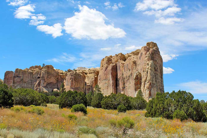
El Morro National Monument, New Mexico.
El Morro National Monument, New Mexico – Also known as “Inscription Rock,” this massive rock formation rises more than 200 feet above the plains. On top of the formation are the remains of two Anasazi pueblos, the most complete of which is A’ts’ina, built in 1275 A.D. With almost 900 rooms, this pueblo is thought to have housed between 1000 and 1500 people. El Morro’s base contains hundreds of Indian petroglyphs and the chiseled names of numerous explorers, soldiers, settlers, and immigrants. The first European inscription was made in 1605 by Juan de Oñate, the first governor of New Mexico. The National Park Service administers the National Monument and is 43 miles southwest of Grants, New Mexico, off NM 53. It is open daily. Contact: El Morro National Monument, HC 61 Box 43, Ramah, New Mexico 87321, 505-783-4226 ext. 0.
Escalante Ruin, Colorado – The Escalante Ruin was first investigated in 1776 by the Domínguez-Escalante Expedition, which was looking for a northern route from the New Mexico missions to those at Monterey, California. The ruin consists of a partially excavated multi-storied masonry pueblo with at least 20 rooms and a kiva. Built by the San Juan Anasazi between 900 and 1300 A.D., it represents the small surface pueblos once typical throughout the region. The Escalante Ruin is located at the Anasazi Heritage Center, an anthropological museum with exhibits on prehistoric Anasazi culture. It is two miles south of Dolores, Colorado, on CO 145, then ½ mile west on CO 184. A trail leads from the Anasazi Heritage Center to the ruin. It is open daily. More Information: Escalante Ruin, 27501 Highway 184, Dolores, Colorado 81323, 970-882-5600.

Gila Cliff Dwellings, New Mexico, courtesy of National Park Service.
Gila Cliff Dwellings National Monument, New Mexico – This National Monument preserves cliff dwellings and other significant archeological remains left by prehistoric American Indians of the Mogollon Culture. The well-preserved cliff dwellings, constructed in the late 1200s, contain 42 rooms within five natural caves in a narrow side canyon above the Gila River. It is 44 miles north of Silver City, New Mexico, at the end of NM 15. The Cliff Dwellings Trail and the Visitor Center are open daily. More information: Gila Cliff Dwellings National Monument, H.C. 68 Box 100, Silver City, New Mexico 88061, 575-536-9461.
Homolovi Ruins State Park, Arizona – In the high grassland of 14th-century northern Arizona, Ancient Puebloans found a home along the Little Colorado River. The Hisat’sinom (known to archaeologists as the Anasazi) paused in their migrations to till the rich flood plain and sandy slopes before continuing north to join people already living on the mesas, today known as the Hopi. The Hopi people of today still consider Homolovi and other pre-Columbian sites in the southwest part of their homeland. They continue to make pilgrimages to these sites, renewing people’s ties to the land. The site includes a visitor center and museum. More information: Homolovi Ruins State Park.

Hovenweep Grand Kiva, Colorado, by Carol Highsmith.
Hovenweep National Monument, Colorado & Utah – Hovenweep National Monument protects six prehistoric Pueblo villages built between A.D. 1200 and 1300, which may have served as ceremonial centers. In a 20-mile expanse of mesa tops along the Colorado–Utah border, the National Monument is noted for its solitude and undeveloped, natural character. The name Hovenweep was bestowed on the region by explorer and photographer William Jackson in 1874. It is a Ute Indian word meaning “deserted valley,” referring to numerous small river valleys that feed into lower McElmo Creek and the San Juan River. Proclaimed as a National Monument on March 2, 1923, by President Warren G. Harding, four Pueblo villages are located in Colorado, including Holly Canyon, Hackberry Canyon, Cutthroat Castle, and Goodman Point.
Kinishba Ruins, Arizona – Kinishba Ruins is a sprawling, 600-room pueblo archaeological site in eastern Arizona that combines Mogollon and Anasazi cultural traits and is considered ancestral to both the Hopi and Zuni cultures. The pre-Columbian Mogollon culture constructed the large pueblo ruin containing nine masonry buildings between 1250 and 1350 A.D. The pueblo is situated on the upper end of a grass-covered valley and originally had 400-500 ground-floor rooms standing two or three stories high. At its peak, Kinishba may have housed up to 1000 occupants. For unknown reasons, the pueblo was vacated in the late 14th and early 15th centuries. Kinishba Ruins, a National Historic Landmark, is seven miles west of Whiteriver, Arizona, off AZ 73 on the Fort Apache Indian Reservation. For more information, call 520-338-4625.
Lowry Ruins, Colorado – Named after early homesteader George Lowry, this ancient pueblo was constructed about 1060 AD atop abandoned pit houses from an earlier occupation. Its 40-100 inhabitants were farmers who hunted small game, made elaborately decorated pottery, and wove cotton from trade. Lowry Pueblo was excavated during summer field seasons (1930-1936) by Paul S. Martin of the Field Museum of Natural History in Chicago. It was declared a National Historic Landmark in 1967 and part of the Canyons of the Ancients National Monument. Lowry’s architecture and masonry indicate a strong influence from Chaco Canyon, about 100 miles south of New Mexico. Lowry, among the northernmost Chaco-style communities, may have formed an interdependent network spread thinly across the eastern half of the Ancestral Pueblo homeland. It is located 27 miles northwest of Cortez, Colorado. More information: Canyons of the Ancients National Monument/Anasazi Heritage Center, 27501 Highway 184, Dolores, Colorado 81323, 970-882-5600.
Mesa Verde National Park, Colorado – For over 700 years, the Ancestral Pueblo people built thriving communities on the mesas and in the cliffs of Mesa Verde. Today, the park protects the rich cultural heritage of 27 Pueblos and Tribes and offers visitors a spectacular window into the past. This World Heritage Site and International Dark Sky Park is home to over a thousand species, including several that live nowhere else on Earth.

Montezuma Castle, Arizona, by Kathy Alexander.
Montezuma Castle National Monument, Arizona – Montezuma Castle was built by prehistoric Indians in the early 1100s and was named by Anglo-American settlers who mistakenly believed Aztec Indians had built it. Situated in a cliff recess 100 feet above the Verde Valley, Montezuma Castle is a five-story pueblo with 20 rooms, similar to the many Anasazi dwellings throughout the Southwest. Nearby is Castle A, a 45-room pueblo built at the base of the cliff. Montezuma Well, just north of the pueblos, is a large limestone sink used by the Pueblo inhabitants for irrigation. In the early 1400s, the valley was vacated for unknown reasons. Montezuma Castle National Monument, administered by the National Park Service, is north of Camp Verde, Arizona, off I-17. A self-guided tour is available. A Visitor’s Center and museum are open daily. 527 S. Main, P.O. Box 219, Camp Verde, Arizona 86322, 928-567-3322.
Mule Canyon Ruins, Utah – A small Anasazi village, this Ancient Puebloan ruin is located on Cedar Mesa in southeastern Utah. Well-preserved pueblo surface ruins found at this site are over 700 years old. The ruin complex includes above-ground and underground dwellings: a kiva, an excavated and stabilized tower, and a block of twelve rooms. The Bureau of Land Management administers Mule Canyon Ruin. The Mule Canyon Ruin site is about 20 miles south and west of Blanding, Utah. It may be accessed from Highway 95. It has a paved parking area, which is well-signed on the north side of the highway. More information: Mule Canyon Ruins, BLM Monticello Field Office, 365 North Main, P.O. Box 7, Monticello, Utah 84535, 435-587-1500.

Navajo National Monument.
Navajo National Monument, Arizona – This Monument, administered by the National Park Service, contains three large prehistoric Anasazi Indian cliff dwellings constructed between 1200 and 1300 A.D. Keet Seel, with over 160 rooms including six kivas, is the largest cliff dwelling in Arizona; Betatakin Ruin has 135 rooms including living quarters, granaries and one kiva; and Inscription House, the smallest of the three, has 44 rooms, several granaries, and one kiva. The pueblos were vacated in the 1300s, probably due to erosion that depleted soil on the canyon floor and lowered the water table. The Monument is 30 miles southwest of Kayenta, Arizona, off US 160 on AZ 564. The Visitors Center is near the Betatakin Ruin site and is open daily, except for major holidays. Two self-guided overlook trails are open year-round. Ranger-guided tours of Keet Seel and Betatakin cliff dwellings are available from Memorial Day to Labor Day and usually during the winter, spring, and fall. More information: Navajo National Monument, HC 71 Box 3, Tonalea, Arizona 86044, 928-672-2700.
Pecos National Historic Park, New Mexico – Pecos is a natural and cultural crossroads through which hunters, gatherers, traders, missionaries, immigrants, soldiers, ranchers, and other travelers passed and lived. Follow in their footsteps and imagine Pecos through the centuries. Visit sites where cultural demonstrations and traditional practices continue today – a living legacy of those who passed this way. It is near Pecos, New Mexico.
Petroglyph National Monument, New Mexico – It protects one of the largest petroglyph sites in North America. It features designs and symbols carved onto volcanic rocks by Native Americans and Spanish settlers 400 to 700 years ago. These images are a valuable record of cultural expression and hold profound spiritual significance for contemporary Native Americans and the descendants of the early Spanish settlers. The monument is near Albuquerque, New Mexico.
Pueblo Grand Ruin, Arizona – Pueblo Grande Ruin, a National Historic Landmark, is a large prehistoric Hohokam Indian village site that was continuously occupied between 100 and 1450 A.D. Heavily influenced by contacts with Mexico, the Hohokam built a Central American-style ball court and a large masonry platform mound surrounded by caliche-brick dwellings between 1150 and 1450 A.D. The mound covers 3.3 acres and stands 20 feet high. The Pueblo Grande Museum contains exhibits on the Hohokam people. Admission fee. Located at 4619 E. Washington St. in Phoenix, Arizona. A self-guided trail leads to the ruin.
Pueblo Grande de Nevada – Also known as the “Lost City,” a complex of villages near Overton, Nevada. Founded by the Basketmaker people in about 300 A.D., it was later occupied by other groups, including the Ancient Puebloans (Anasazi), until 1150 A.D. Most of the city was submerged beneath Lake Mead when the Hoover Dam was built. However, not all sites were submerged by the lake, and luckily, hundreds remained above water. Various artifacts were preserved for display at the Lost City Museum of Archaeology in Overton, Nevada.

Salmon Ruins, New Mexico.
Salmon Ruins, New Mexico – Located on the north bank of the San Juan River, the Salmon Pueblo was constructed between 1088 and 1090 A.D. Built during the same time as many of the great houses in Chaco Canyon, some 45 miles to the south, this large Chaco pueblo originally contained over 300 rooms on three levels. Some of the many astronomical alignments at the site appear to have been set in place as early as 1068. The initial structure is thought to have been completed in just two years, carrying trees and rock from up to 50 miles away. However, they abandoned the site after just about 25-30 years. The reason is unknown. Around 1160 A.D., the Ancestral Puebloans (Anasazi) began the “Secondary Occupation.” Many structural modifications were made to the Salmon, which remained the largest pueblo on the San Juan River until it was abandoned again around 1265 A.D. Well-marked paths lead through the excavated ruins. More information: Salmon Ruins, 6131 Highway 64, Bloomfield, New Mexico.

Tonto National Monument.
Tonto National Monument, Arizona – Tonto National Monument, administered by the National Park Service, contains three prehistoric Salado Indian cliff dwellings constructed from about 1250 to 1300 A.D. The Monument consists of the Upper Ruin, with 32 ground-floor rooms and eight second-story rooms; the Lower Ruin, with 16 ground-floor rooms and three second-story rooms; and the Lower Ruin Annex. There are also at least 62 additional sites. The Salado were primarily farmers descended from the Hohokam who settled the Tonto Basin in the 700s. Between 1400 and 1450, the Salado vacated their cliff dwellings for unknown reasons. Tonto National Monument is 31 miles northwest of Globe, Arizona, on Arizona 88. A Visitor’s Center and museum are open daily. 26260 N AZ Hwy 188 #2, Roosevelt, Arizona 85545, 928-467-2241.
Tuzigoot National Monument, Arizona – Tuzigoot is the remnant of a prehistoric Sinagua pueblo constructed between 1125 and 1400 A.D. It is located on the summit of a steep hill overlooking the Verde River, one of Arizona’s few permanent streams. The Sinagua were sedentary farmers who appeared to have practiced floodwater agriculture. The pueblo originally had 86 ground-floor rooms, some with two stories, entered through roof openings reached by ladders. In the early 1400s, the pueblo was vacated for unknown reasons. Tuzigoot National Monument, administered by the National Park Service, is two miles north of Cottonwood, Arizona, off Alternate Rte. 89. The Monument and Museum are open daily. Tuzigoot Visitor Center, 527 S. Main St, Camp Verde, Arizona 86322, 928-634-5564.
Ute Mountain Tribal Park, Colorado – Part of the Ute Mountain Ute Indian Reservation, the Tribal Park has been set aside to preserve the Ancestral Puebloan remnants of Ute cultures. The Park encompasses approximately 125,000 acres around a 25-mile stretch of the Mancos River. The park has hundreds of surface sites, cliff dwellings, petroglyphs, and historic Ute wall paintings. The Tribal Park is a primitive area to protect its cultural and environmental resources. Tours are guided by Ute Indians’ broad knowledge of Ute and Ancestral Puebloan cultures. The tours include history, rock art, surface sites, and cliff dwellings. Self-guided tours are not permitted to protect fragile resources. More information: Ute Mountain Tribal Park, P.O. Box 109, Towaoc, Colorado 81334, 970-749-1452.

Walnut Canyon Indian Ruins.
Walnut Canyon National Monument, Arizona – Having over 240 prehistoric Sinagua Indian sites, these include pit house villages built between 500 and 800 A.D. and several multi-room cliff dwellings and single-room field houses c. 1125 and 1250 A.D. By about 1250 A.D., the Sinagua had moved on, leaving the sites as the most obvious reminder of their habitation. Walnut Canyon National Monument, administered by the National Park Service, is 7 1/2 miles east of Flagstaff, Arizona, off I-40. The Visitors Center is open daily. Contact: Flagstaff Area National Monuments, 6400 N. Hwy 89, Flagstaff, Arizona 86004, 928-526-3367.
Wupatki National Monument, Arizona – This Monument comprises nearly 2,700 archeological sites, the vast majority of which are Sinagua and Anasazi, dating from about 100-1250 A.D. The two largest dwellings, built between 1100 and 1250 A.D., are Wupatki, with up to 100 rooms built against and atop a mesa, and Citadel, a 50-room structure that almost surrounds a central plaza. The Monument contains many smaller pueblo ruins, pit houses, reservoirs, petroglyphs, and a masonry ball court. The pueblos were permanently abandoned by about 1250 A.D., perhaps due to prolonged drought or overuse of natural resources. Wupatki National Monument is 35 miles north of Flagstaff, Arizona, off U.S. 89. The Visitors Center is open daily. Contact: Flagstaff Area National Monuments, 6400 N. Hwy 89, Flagstaff, Arizona 86004, 928-679-2365.
Yucca House National Monument, Colorado – Located near Cortez, Colorado, this site preserves a large unexcavated pueblo in a stunning Montezuma Valley setting between Mesa Verde and Ute Mountain. Toward the base of Ute Mountain is the “West Complex,” a large pueblo with an estimated 600 rooms, over 100 kivas, and a great kiva. A productive spring flows through the middle of the complex. “Upper House,” the highest portion of the West Complex, rises 15 to 20 feet above the nearby architecture, dominating the surrounding landscape. It must have been an impressive building. To your east is the “Lower House,” which has some of the site’s only visible standing masonry. The “Lower House” is an L-shaped pueblo with at least eight first-story rooms. A low wall encloses the plaza, with a great kiva at its center. Yucca House, one of the most significant archeological sites in southwest Colorado, acted as an essential community center for the Ancestral Puebloan people from A.D. 1150-1300. Since it was designated a national monument in 1919, it has remained largely untouched, offering intrepid visitors a sense of discovery while preserving the pueblo’s beauty and integrity for future generations.
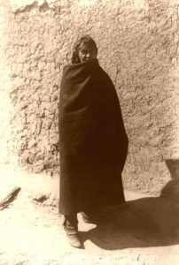
Pueblo Indian Man, 1902.
©Kathy Alexander/Legends of America, updated October 2025.
Also See:
Ancient Cities of Native Americans
Ancient Puebloans of the Southwest
Pueblo Indians – Oldest Culture in the U.S.
Pueblo and Reservation Etiquette
Spanish Missions in New Mexico
See Sources.