“Westward, ever westward.”
— Henry Wells
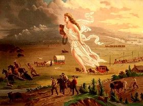
American Progress by John Gast in 1872.
The “Frontier” is defined as “a region at the edge of a settled area.” The “American Frontier” began with European settlement on the Atlantic coast and the eastern rivers. The “Frontier” was most often categorized as the western edge of settlement from the start. However, this was not always the case, as English, French, Spanish, and Dutch patterns of expansion and settlement were quite different. Thousands of French migrated to Canada early on, and French fur traders ranged widely through the Great Lakes and Mississippi River watersheds and as far as the Rocky Mountains; however, they rarely built settlements. The Dutch, however, did establish permanent villages and trading posts in the Hudson River Valley but did not push westward. The English, in the meantime, generally built compact settlements and didn’t push too far westward.
In the 17th century, the frontier had advanced up the Atlantic river courses, and the tidewater region became the settled area. In the first half of the 18th Century, another advance occurred. Trappers and traders followed the Delaware and Shawnee Indians to the Ohio River as early as the end of the first quarter of the century.
Governor Spotswood of Virginia made an expedition in 1714 across the Blue Ridge. The end of the first quarter of the century saw the advance of the Scotch-Irish and the Palatine Germans up the Shenandoah Valley into the western part of Virginia and along the Piedmont region of the Carolinas. The Germans in New York pushed the frontier of settlement up the Mohawk River to German Flats. In Pennsylvania, the town of Bedford indicated the line of settlement. Settlements had also begun on New River, a branch of the Kanawha, and on the sources of the Yadkin and French Broad Rivers.
The French and Indian Wars of the 1760s resulted in a complete victory for the British, who took over the French colonial territory west of the Appalachian Mountains to the Mississippi River. Settlers then moved across the Appalachians into areas such as the Ohio Country and the New River Valley. The King attempted to arrest the advance by his proclamation of 1763, forbidding settlements beyond the sources of the rivers flowing into the Atlantic; however, his proclamation would be in vain. From the beginning, the East feared the result of an unregulated advance of the frontier and tried to check and guide it, but would never be able to stop the flow of people heading westward.

Battle of Princeton.
Following the victory of the United States in the American Revolution and the signing of the Treaty of Paris in 1783, the United States gained control of the British lands west of the Appalachian Mountains. During this time, thousands of settlers, such as Daniel Boone, crossed the Alleghanies into Kentucky and Tennessee, and the upper waters of the Ohio River were settled. Some areas, such as the Virginia Military District and the Connecticut Western Reserve, both in Ohio, were used by the states to reward veterans. How to formally include these new frontier areas into the nation was an important issue in the Continental Congress of the 1780s and was partly resolved by the Northwest Ordinance in 1787.
When the first census was taken in 1790, the continuously settled area was bounded by a line that ran near the coast of Maine. It included New England except for a portion of Vermont and New Hampshire, New York along the Hudson River and up the Mohawk about Schenectady, eastern and southern Pennsylvania, Virginia well across the Shenandoah Valley, and the Carolinas and eastern Georgia. Beyond this region of continuous settlement were the small settled areas of Kentucky and Tennessee, as well as the Ohio River, with the mountains separating them and the Atlantic area. The region’s isolation caused the region to be called the “West,” and the concept of the Western Frontier began to evolve.
For the next century, westward expansion would increase following the Louisiana Purchase in 1803 and the subsequent Lewis and Clark Expedition. By 1820, the settled area included Ohio, southern Indiana and Illinois, southeastern Missouri, and about half of Louisiana. These settled areas often surrounded Indian lands, which the settlers protested against, resulting in the Indian Removal Act of 1830. The frontier region of the time lay along the Great Lakes, where John Jacob Astor’s American Fur Company operated in the Indians trade. Beyond the Mississippi River, Indian traders extended their activity to the Rocky Mountains.
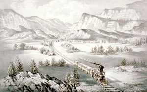
The Great West by Currier & Ives
The rising steam navigation on western waters, the opening of the Erie Canal in 1825, and the westward extension of cotton culture added five frontier states to the Union. In the meantime, the federal government continued to expand the nation.
In 1845, it annexed Texas, and in 1846, the Oregon Treaty ended British claims to Oregon Territory. In 1848, following the Mexican-American War, Mexico ceded much of the West and Southwest to the United States. This included what would become the states of California, Nevada, Utah, parts of Arizona, Colorado, New Mexico, and Wyoming. In 1853, the United States bought an additional tract of land from Mexico. These new territories attracted hundreds of thousands of settlers.
By the middle 1800s, the frontier line was indicated by the present eastern boundary of Indian Territory (Oklahoma), Nebraska, and Kansas. Minnesota and Wisconsin still exhibited frontier conditions, but the distinctive frontier of the period was found in California, where the gold discoveries had sent a sudden tide of adventurous miners, and in Oregon and the settlements in Utah.
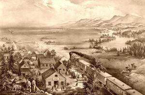
Across the Continent by Currier & Ives.
As the frontier had leaped over the Alleghanies, so now it skipped the Great Plains and the Rocky Mountains. In the same way that the advance of the frontiersmen beyond the Alleghanies had caused the rise of important questions of transportation and internal improvement, so now the settlers beyond the Rocky Mountains needed a means of communication with the East.
In the meantime, the question of whether the Kansas frontier would become a “slave” or “free state” was one of the many sparks of the Civil War. Despite the war’s expense, the nation continued to move forward with westward expansion. In general, before 1860, Northern Democrats promoted easy land ownership, and Southern Democrats resisted it because it supported the growth of a free farmer population that might oppose slavery.
When the Republican party came to power in 1860, they promoted a free land policy — notably the Homestead Act of 1862, coupled with railroad land grants that opened cheap lands for settlers. The First Transcontinental Railroad was built between 1863 and 1869, which linked the existing railway network of the Eastern United States with the West Coast for the first time. During this time, the United States Army fought a series of Indian Wars in Minnesota, Dakota, and other places in the West as the tide of settlers moved across the nation.
By 1880, the settled area had been pushed into northern Michigan, Wisconsin, and Minnesota, along the Dakota rivers, and in the Black Hills region, and was ascending the rivers of Kansas and Nebraska.

Colorado Miners.
Mining in Colorado had drawn isolated frontier settlements into that region, and Montana and Idaho were receiving settlers. By this time, the frontier was found in these mining camps and the ranches of the Great Plains. The far western frontier had been settled in just a quarter of a century. Three million families started farms on the Great Plains during these years.
By 1890, the Superintendent of the census reported that the settlements of the West were so scattered over the region that there could no longer be said to be a frontier line. Census maps defined the frontier line as a line beyond which the population was under two persons per square mile. The original report stated:
“Up to and including 1880, the country had a frontier of settlement; but, at present, the unsettled area has been so broken by isolated bodies of settlement that there can hardly be said to be a frontier line.”
This brief official statement marked the closing of a great historic movement. Four centuries from the discovery of America, at the end of a hundred years of life under the Constitution, the frontier has gone.
Contrary to the popular image of the West as a rural region, by 1890, most of the West’s population lived in cities. Not only was the Trans-Mississippi West the country’s most culturally diverse region, but it was also the most urbanized by 1890.
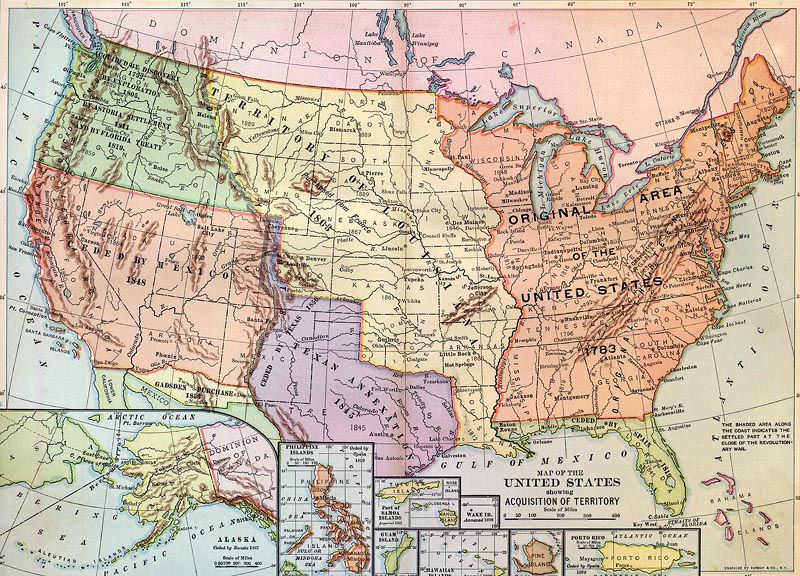
Westward Expansion Map
©Kathy Alexander/Legends of America, updated April 2025.
Also See:
The Frontier In History by Emerson Hough
Frontier Types by Theodore Roosevelt
Frontier Wars by Emerson Hough
See Sources.