
San Antonio–San Diego Mail Line Map, courtesy of City of Santa Clarita, California.
The San Antonio-San Diego Mail Line, also known as the Jackass Mail, was the earliest overland stagecoach and mail operation from the Eastern United States to California. The overland mail route operated between 1857 and 1861.
Beginning in 1850, the Post Office Department issued a series of contracts to carry mail along portions of the California Trail, but no through service was provided. Two major overland postal routes were in operation: one connected Missouri and Salt Lake City, Utah, and another connected Salt Lake City and California. Steamers across the Isthmus of Panama carried most transcontinental mail.
Due to demand from California residents for better mail service, Congress passed a postal bill on August 18, 1856. Though the favored route was to run from St. Louis, Missouri, through South Pass to San Francisco, the mail route was established between San Antonio, Texas, and San Diego, California. This angered the folks in Northern California, causing a local newspaperman to declare the line went “from no place through nothing to nowhere.”
Another act, enacted on December 19, 1856, authorized the construction of a military road from El Paso, Texas, to Fort Yuma, Arizona, along with the military posts necessary to safeguard the route. This new route was intended to be faster and more cost-effective. The construction of the military road was completed soon after.

James E. Birch.
In the meantime, James E. Birch, a stagecoach line entrepreneur and founder of the California Stage Company, who’d made a fortune running stagecoaches during the California Gold Rush, envisioned that at New Orleans, Louisiana, mail could be loaded onto a five-times-a-week mail steamer bound for Indianola, Texas, 540 miles away. It could be transferred to a daily line of four-horse mail coaches traveling 140 miles to San Antonio, Texas. Then, the mail could be carried on a San Antonio and San Diego Line, 1,476 miles from San Antonio via the San Antonio-El Paso Road, before continuing north to Mesilla, New Mexico, and taking the Southern Emigrant Trail to San Diego. Once on the Pacific Coast, the mail could board a California Steam Navigation Company vessel to San Francisco.
Birch had some powerful friends in Washington, D.C., so it was no surprise that when the contract was awarded on June 22, 1857, he emerged as the winner. He picked up a $600,000 government subsidy to haul the mail and passengers, effective for four years, from July 1, 1857. The stageline was created, organized, and financed by James E. Birch, the head of the California Stage Company. He was awarded the first contract for overland service on the “Southern Route,” between San Antonio and San Diego, designated Route 8076, which required a semi-monthly service in four-horse coaches at $149,800 per year. The 1,476-mile route was to be traversed in 30 days, leaving San Antonio, Texas, and San Diego, California, at 6:00 a.m. on the 9th and the 24th of each month. The one-way fare was $200 and included all meals and a baggage allowance of 30 pounds.
From the eastern terminus at San Antonio, there was a daily stagecoach mail to Indianola, Texas, which connected with five steamers to New Orleans, Louisiana, five times a week. Eastbound and westbound carriers were to meet at Maricopa Wells, Arizona, on the 16th of each month to exchange mail. The San Antonio-San Diego Mail Line soon became the first transcontinental mail route in the United States.

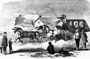
The Overland Mail by Charles Schreyvogel, 1900.
James Birch partnered with George H. Giddings of the San Antonio-El Paso Mail, which already operated over half of the route to Mesilla, New Mexico. Along this route, there were 87 watering places and stage stations, organized by Superintendent Isaiah C. Woods, formerly with Adams & Company in San Francisco, California. They established the mail line during the first run as mule trains and coaches headed west from San Antonio. Superintendent Woods prepared a self-sufficient outfit for this journey across the largely unsettled regions of Texas, the New Mexico Territory, and Southern California, where there was little existing infrastructure. The vehicles used for transport were celerity or mud wagons, also known as ambulances, rather than the more famous Concord stagecoach.
Water holes were established at 30-mile intervals, but many were unmanned, and the actual stations were sometimes separated by as much as 100 miles. These first stations were, at most, brush corrals and jacals to house the keepers, while most were merely camping places at springs or stream crossings; camps would be made where the coaches stopped for the night. Only the three in San Antonio, El Paso, and San Diego had substantial buildings. The largest and most important station between El Paso and San Diego was at Maricopa Wells, Arizona, the dividing point on the route, where the eastbound and westbound mails met and turned back. An adobe house and corral were erected here. During the company’s existence, it employed 65 men in all capacities and owned 50 coaches and 400 mules.

San Antonio-San Diego Mail Line.
George H. Giddings, the agent for Birch and prior mail contractor for the route connecting San Antonio and El Paso, placed James E. Mason in charge. The first westbound mail under the Birch contract departed San Antonio on July 9, 1857, 17 days after Birch concluded his contract. The stage was driven by the celebrated old Texas Ranger, “Big Foot” Wallace.
A second westbound mail departed on July 24 under Captain Skillman’s supervision. James Mason and Big Foot Wallace were delayed in Texas by Indian attacks and proceeded only after being joined by Skillman near El Paso. As a result, the first and second mails arrived in San Diego together on August 31, 1857. The average rate of travel over the route was about 40 miles a day.
The first eastbound trip departed San Diego on August 9, 1857.
The stage passengers complained loudly of the difficulties encountered. Though there were 87 way stations along the route, only three, San Antonio, El Paso, and San Diego, had any amenities. The rest were little more than brush corral and mud-walled hovels, or merely camping places at springs or stream crossings.
The food served was barely edible, consisting of tough beef or pork fried in a grimy skillet, coarse bread, mesquite beans, and a questionable dish known as “slumgullion.” To wash it down, there was a strong, bitter coffee. Dessert was a disappointing mix of dried apples that masqueraded as apple pie.
Additionally, the stagecoach floors were dirty, prompting one writer to state that “they were much like the ground outside, except not as clean.”
There were three classes of passengers, which were treated differently. When the stage reached a steep grade, first-class passengers remained in the coach; the second-class passengers were forced to get out and walk, and those traveling third class had to get out and push the coach up the hill.

Colorado Desert, courtesy Wikipedia.
The stagecoach line was dubbed the “Jack Ass Mail” because in the most severe part of the journey, crossing the California Desert just west of the Colorado River, in the rugged backcountry near San Diego, California, no stages could pass. At this time, passengers were forced to ride on the backs of mules (jackasses) to cross roughly 100 miles of the Colorado Desert in California. Mules were necessary because the terrain was too harsh for the stagecoaches.
James Birch left San Francisco for the East on August 20, 1857, before the completion of the inaugural trips. He was lost at sea on September 12 when the steamship Central America sank in the Gulf of Mexico. Isaiah Wood, previously his agent in California, and George Giddings continued the business. Only about 40 trips were ever made over the entire route before the service was curtailed. The Postmaster General reported postal receipts on the route of $601 with a loss of $195,399.
Effective January 1, 1858, the post office transferred the contract for route 8,076 to George Giddings at the same compensation. Birch’s estate sold the line to the firm of G.H. Giddings and R.E. Doyle in May 1858.
Giddings and Doyle improved the line and expanded their business to include passengers, becoming the first transcontinental, overland passenger service. A newspaper advertisement, under a banner illustrating a four-horse stage coach, proclaimed:
“Overland to the Pacific, the San Antonio and San Diego Mail Line
This line, which has been in successful operation since July 1857, tickets passengers through to San Diego and all intermediate stations. The passenger and express matter were forwarded in new coaches drawn by six mules over the entire length of our line, except for the Colorado Desert, which is 100 miles long, and we cross on a mule back. Passengers guaranteed their tickets to ride in coaches, except for the 100 miles above the stated distance. An armed escort travels through the Indian country with each mail train for the protection of the mail and passengers.”
Unfortunately, James E. Birch’s pioneering accomplishment of establishing the mail route in 1857 was overshadowed by the Butterfield line.
Butterfield Overland Mail
The Butterfield stage starts its journey in Tipton, Missouri.
The Butterfield Overland Mail usurped a portion of Birch’s line and rapidly became the dominant overland mail carrier to California before the Civil War.
On September 20, 1858, the Butterfield Overland Mail Company began operating its stage line over the road, using the station sites pioneered by Birch and Woods from El Paso, Texas, to Warner’s Ranch, California. The Butterfield line did not absorb the San Antonio–San Diego Line. However, on December 1, 1858, the portion of the route between El Paso and Fort Yuma was withdrawn from service because it duplicated the Butterfield Overland route. The service from San Antonio to El Paso and Fort Yuma to San Diego was upgraded from semi-monthly to weekly trips, and its subsidy was increased.
In 1860, the west end of the route from Fort Yuma to San Diego was discontinued, leaving only the 367-mile portion from San Antonio to Camp Stockton, Texas, which was operated weekly. Between Camp Stockton and El Paso, it was done weekly. The service was thus improved to a weekly basis from New Orleans to San Francisco.
Overland Mail Corporation
After the final suspension of the Butterfield Overland Mail on March 12, 1861, the San Antonio and San Diego Mail Line reorganized and merged its interests under the title of the Overland Mail Corporation. In May 1861, this company was given a new contract for the year ending June 30, 1862, to operate a mail service over the entire route from San Antonio via Camp Stockton to Tucson and points in California. An attempt was made to fulfill the contract beginning April 1. However, with the development of the Civil War and Apache attacks on the stations and coaches of the line resulting from the Bascom Affair, the contractors gave up. The eastern portion of the line was curtailed on June 30, 1861. The end came when the Camp Stockton-to-Tucson segment of the line was discontinued on August 2, 1861.
Mail Line Stations
San Antonio to Leon River, 6.53 miles
Leon River to Castroville, on the Medina River, 18 miles
Castroville to D’Hanis Seco River, 25.28 miles
D’Hanis to Ranchero Creek, 8.38 miles
Ranchero Creek to Sabinal Creek, 3.94 miles
Sabinal Creek to Camanche Creek, 5 miles
Camanche Creek to Rio Frio, 8.46 miles
Rio Frio to Head of Leona River, “Uvalde,” 6.08 miles
Uvalde to Nueces River, 9.04 miles
Nueces to Turkey Creek, 10.27 miles
Turkey Creek to Elm Creek, 15.23 miles
Elm Creek to Las Moras River, Fort Clarke, 7.13 miles
Total- 123.34 miles
Fort Clarke to Piedra Pinto, 7 miles
Piedra Pinto to Maverick Creek, 8.86 miles
Maverick Creek to San Felipe Springs, 12.61 miles
San Felipe to the first crossing of San Pedro or Devil’s River, 10.22 miles
First Crossing to Painted Caves, 2.54 miles
Painted Caves to California Spring, 15.73 miles
California Spring to Willow Spring, 2 miles
Willow Spring to Fort Hudson, and second crossing Pedro or Devil’s River, 16.39 miles
Total – 75.35 miles
Fort Hudson to Head of San Pedro or Devil’s River, 19.5 miles
Head of the river to Howard Springs, 44 miles
Howard Springs to Live Oak Creek, 30.44 miles
Live Oak Creek to Fort Lancaster, 3 miles
Total- 96.94 miles
Fort Lancaster to Pecos Crossing, 4.29 miles
Pecos Crossing to Pecos Spring, 6 miles
Pecos Spring to Leaving of Pecos, 32.26 miles
Leaving Pecos to Arroyo Escondido, 16.26 miles
Arroyo Escondido to Escondido Spring, 8.58 miles
Escondido Spring to Comanche Springs, 19.4 miles
Comanche Spring to Leon Hole, 8.88 miles
Leon Hole to Hackberry Pond, 11 miles
Hackberry Pond to Limpia Creek, 32 miles
Limpia Creek to Fort Davis, 18.86 miles
Total – 157.99 miles

Fort Davis, TX – Commanding Officer’s Quarters.
Fort Davis to Point of Rocks, 10 miles
Point of Rocks to Barrel Springs, 8.42 miles
Barrel Springs to Deadman’s Hole, 13.58 miles
Deadman’s Hole to Van Horn’s Wells, 32.83 miles
Van Horn’s Wells to Eagle Springs, 19.74 miles
Eagle Springs to First camp on the Rio Grande, 31.42 miles
First camp on the Rio Grande to Birchville, 35 miles
Total – 150.99 miles
Birchville to San Elizario, 24.8 miles
San Elizario to Socorro, 5.45 miles
Socorro to Isletta, 3.1 miles
Isletta to El Paso, 14.14 miles
Total – 47.49 miles
El Paso to Cottonwood, 22 miles
Cottonwood to Fort Fillmore, 22 miles
Fort Fillmore to La Mesilla, 6 miles
Total – 50 miles
Early Mesilla by Carl Schuchard, 1854.
La Mesilla to Cook’s Spring, 65 miles
Cook’s Spring to Rio Mimmbres, 18 miles
Rio Rio Mimmbres to Ojo La Vaca, 17 miles
Ojo La Vaca to Ojo de Ynez, 10 miles
Ojo de Ynez to Peloncilla, 34 miles
Peloncilla to Rio Saur or San Domilesngo, 18 miles
Rio Saur to Apache Springs, 23 miles
Apache Springs to Dos Cabesas Springs, 9 miles
Dos Cabesas Springs to Dragoon Springs, 26 miles
Dragoon Springs to the mouth of Quercos Canyon, 18 miles
Mouth of Quercos Canyon to San Pedro crossing, 6 miles
San Pedro to Cienega, 20 miles
Cienega to Cienega Creek, 13 miles
Cienega Creek to Mission San Xavier, 20 miles
Mission San Xavier to Tucson, 8 miles
Total – 305 miles
Tucson to Pico Chico Mountain, 35 miles
Pico Chico to First camp on Gila River, 35 miles
First camp on the Gila River to Maricopa Wells, 29 miles
Total – 99 miles

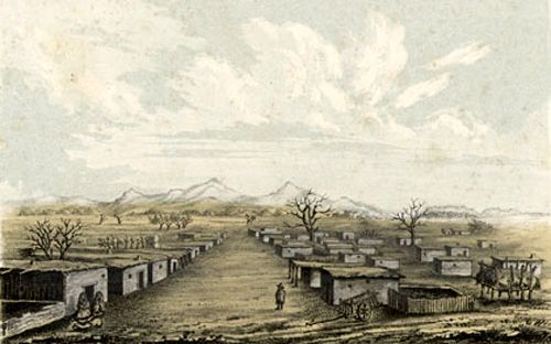
Maricopa Wells Station, Arizona.
Maricopa Wells to Tezotal, across Jornada, 40 miles
Tezotal to Ten-Mile Camp, 10 miles
Ten-mile Camp to Murderer’s Grave, 8 miles
Murderer’s Grave to Oatman’s Flat, 1st crossing of Gila River, 15 miles
Oatman’s Flat to the 2nd crossing of the Gila River, 25 miles
2nd crossing of the Gila River to Peterman’s Station, 32 miles
Peterman’s station to Antelope Peak, 20 miles
Antelope Peak to Little Corral, 24 miles
Little Corral to Fort Yuma, 16 miles
Total – 190 miles
Fort Yuma to Pilot Knob, 7 miles
Pilot Knob to Cook’s Wells, 13 miles
Cook’s Wells to Alamo Mucho, 21.94 miles
Alamo Mucho to Indian Wells, 20.94 miles
Indian Wells to Carissa Creek, 32.24 miles
Total – 95.12 miles
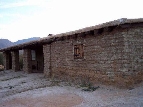
Vallecito Station today.
Carissa Creek to Vallecito, 18 miles
Vallecito to Lassator’s ranch, 18 miles
Lassator’s ranch to Julian’s ranch, 7 miles
Julian’s ranch to Williams’ ranch, 7 miles
Williams’ ranch to Ames’ ranch, 14 miles
Ames’ ranch to San Diego, 16 miles
Mission to San Diego, 5 miles
Total – 85 miles
San Antonio to San Diego Total – 1,475.76 miles
Stagecoach Road from Carrizo Creek Station to San Diego:
Carrizo Creek Station to Vallecito, 18 miles
Vallecito to Rancho Valle de San Felipe, 18 miles
Rancho Valle de San Felipe to Warner’s Ranch, 10 miles
Warners Ranch to San Ysabel, 24 miles
San Ysabel to San Pasqual, 28 miles
San Pasqual to Rancho Santa María de los Peñasquitos, 16 miles
Rancho Penasquitos to San Diego, 20 miles.
Total Distance – 125 miles
©Kathy Alexander/Legends of America, updated March 2026.
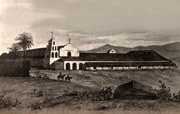
Mission San Diego, California, 1848.
Also See:
Sources:
Frajola, Richard and Risvold, Floyd; Deconstructing the Jackass Mail Route, 2008.
San Diego History Center
True West Magazine
University of Arizona Press
Wikipedia