Gold Creek, Montana
There are numerous ghost towns in Montana that provide vivid peeks into the life in the Old West, especially at the many old mining camps located in the “Treasure State.” From the time that gold was first discovered in Gold Creek in 1852 to the first major gold rush boom in Bannack in July 1862, and all the way through today, millions of dollars in gold, silver, copper, zinc, and other precious ores have been scoured from the mountains of Montana. Some of the best-known mining towns include such places as Virginia City and Nevada City in Alder Gulch; Bannack, where the first gold rush and first territorial capital were located; Elkhorn and Comet, which continue to display numerous old structures; all the way up to Butte, which is not a ghost town but has a long mining history.
Along with these many historic sites, legends and tales of outlaw gangs, road agents, ghosts, and hidden treasures also abound along with the state’s rich history.
Ghost Towns and Mining Camps:

Bannack, Montana
Bannack – From Gold to Ghosts – Beaverhead County, mining camp ghost town, some 50 preserved buildings, currently a state park.
Barker & Hughesville – Ghost Camps in the Little Belt Mountains – Judith Basin County, two mining camps located just two miles apart, a few scattered cabins and mining remnants.
Basin – Mining Camp to Artist’s Retreat – Jefferson County, semi-ghost, mining camp, an active town of about 250 residents, historic buildings, and mining remains.
Cable – Deer Lodge County, abandoned mining camp. Located on private property, what little was left, including the Gold Coin Mine and Mill, have since been torn down.
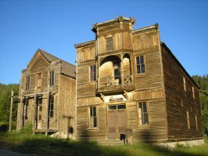
Castle Town, aka: Castle City, Castle – Meager County, mining ghost town, no residents, just a few buildings, privately owned.
Charter Oak Mine & Mill – Powell County, mine, mill, and a few buildings.
Coloma Mining District – Missoula County, just a few tumbling buildings and mining remains.
Comet – Silent on the Eastern Slope – Jefferson County, numerous buildings in various states of decay, mill operations.
Coolidge – Empty of people today and most of its buildings tumbling to the ground, Coolidge, Montana was once a beehive of activity from mining.
Cushman – Golden Valley County, fading remains of old ranching town.
Elkhorn, Montana
Elkhorn Survives – Jefferson County, mining camp, ghost town, several remaining buildings, a few residents.
Ewing – Carbon County, ghost ranch, in Big Horn Canyon National Recreation Area.
Farlin – Beaverhead County, just a few remaining buildings and mining remains.
Garnet – Best Kept Ghost Town Secret – Granite County, mining ghost town, preserved by Bureau of Land Management, several buildings, on-site caretakers, no other residents.
Glendale – See Hecla Mining District
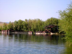
Gold Creek – Powell County, site of first gold discovery, no mining remains in town, but some just to the southwest of town.
Granite – Montana’s Silver Queen – Granite County, mining camp, several buildings, mine, and mill.
Hassel – Broadwater County, mining camp, active mining operation, a few old buildings.
Hecla Mining District – Beaverhead County, remains of several mining camps, including Hecla, Glendale, and Lion Mountain, a few remaining buildings and mining remains.
Homestead – Sheridan County, semi-ghost, railroad/agriculture town, less than 50 residents, no active businesses.
Independence – Park County, mining camp located high in the Absaroka Range, several buildings including an old brothel, mining remains. Requires high clearance vehicle.
Jardine, aka: Bush – Park County, mining remains, old cabins.
Kendall – Fergus County, mining remains, and a few old structures.
Kirkville – Clark County, just a few remaining buildings, private property.
Laurin – Madison County, not a ghost town, mining camp, several historic buildings.
Lion City – See Hecla Mining District
Marysville – Growing Once Again – Lewis and Clark County, mining camp, current residents, restored, preserved, and tumbling buildings. Mine is being reactivated.
Nevada City – Outdoor History Museum – Madison County, one-time mining camp, a collection of original, moved, and recreated buildings.
Pony – Madison County, mining town, semi-ghost, active residents, numerous historic buildings, and mining remains
Princeton – Granite County, only a few dwellings occupied by summer residents.

Old School at Red Bluff, Montana
Red Bluff – Madison County, just a couple of buildings, mining remains to the south.
Rochester – Madison County, mining camp, a few stone buildings, and mining remains.
Rimini Lives On – Lewis and Clark County, mining camp, current residents, several historic buildings.
Southern Cross – Deer Lodge County, a few remaining buildings, endangered due to redevelopment.
Vipond/Quartz Hill – Beaverhead County, a few buildings and mining remains.
Virginia City – A Lively Ghost Town – Madison County, restored mining camp, active town, numerous historic buildings, caters to tourists.
Zortman – Phillips County, mining camp, mining, and building ruins.
Take nothing but photos – leave nothing but footprints – break nothing but silence – kill nothing but time.
—Explorer’s Code
©Kathy Weiser-Alexander, updated October 2024.
Also see: