
20 Mule Team Wagon, Harmony Borax Works, Death Valley, California, by Kathy Alexander.
Since the 1848 discovery of gold in California, Death Valley has experienced over 140 years of boom and bust mining, creating several ghost towns in the area. Little did those many miners passing through the area in 1849 know that there were vast deposits of gold, silver, copper, and borax just waiting to be taken out of the mountains and valley floor.
From the 1880s to the early 1900s, mining was limited and sporadic in the Death Valley region, mainly because many of these early mining districts met with a notable lack of success. Primitive and inefficient technology, scarcity of water and fuel, and the difficulties of transportation made it economically impossible to mine any but the highest-grade ores. Some of the towns that died even before the turn of the century included Kasson, Rhodes Spring, Old Tecopa, Old Stovepipe Wells, Panamint City, and dozens of mines.
However, one of the earliest successful mining operations was the Harmony Borax Works, active from 1883 to 1888. This mill was famous not for its ore deposits but for the Twenty Mule Team wagons used to transport the partially refined borax.
With renewed interest in gold and silver mining, the early 1900s witnessed several new mines and settlements. Skidoo, Rhyolite, and Keane Wonder Mine became large-scale operations. The boom towns that sprang up around these mines flourished during the first decade of the 20th century but soon slowed down after the panic of 1907. Prosperous large-scale metal mining in Death Valley ended around 1915.
In February 1933, President Herbert Hoover signed the proclamation creating Death Valley National Monument, which temporarily closed monument lands to prospecting and filing new mining claims. However, by prior agreement, Congressional action in June of the same year quickly reopened the monument to prospecting and mining.
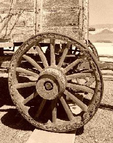
Close-up of a wagon wheel, Twenty Mule Borax Wagon, in Death Valley, California.
As improvements in mining technology allowed lower grades of ore to be processed and new heavy equipment allowed greater amounts of rock to be moved, mining in Death Valley improved. Open-pit and strip mines for borax and talc began to scar the landscape as internationally owned mining corporations bought claims in highly visible locations of the national monument. However, the public outcry that later ensued led to greater protection for all national park areas. Congress passed the Mining in the Parks Act in 1976, which closed Death Valley National Monument to the filing of new mining claims, banned open-pit mining, and required the National Park Service to examine the validity of thousands of pre-1976 mining claims. Mining was allowed to resume on a limited basis in 1980 with stricter environmental standards.
When the area became Death Valley National Park in 1994, the park assumed jurisdiction over hundreds of additional unpatented mining claims. The Billie Mine, an underground borax mine along the road to Dante’s View, was the only active mine in the park for the next decade. In 2005, when the Billie Mine closed, the last of Death Valley’s mines ceased operations.
In its wake, mining created more than 100 ghost towns and mining camps in Death Valley, though these are quickly decaying due to weather, vandalism, and neglect. The ruins of mills, metal and stone buildings, mine openings, and a few still intact towns are throughout the valley.
There are numerous ghost towns in the Death Valley area in California and Nevada. Here is a list with the location and a few notes about what remains for each.
Ghost Towns, Mining Camps, and Closed Mines:
Amargosa, Nevada – East of Amargosa Valley, Nevada – Railroad foundation only. Note: The townsites of Original, Nevada, and Death Valley Junction, California, were also called Amargosa. Bullfrog, Nevada, was briefly called Amargosa City.
Amargosa Borax Works, California – Near Shoshone, California – Foundation remains and low adobe walls.
Arrastre Spring, California, is on the eastern slope of the Panamint Mountains, overlooking the salt flats of Death Valley. It has an old, deteriorating arrastre and numerous petroglyphs.
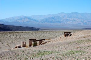
Ashford Mill, Death Valley, California, Dave Alexander.
Ashford Mine and Mill, California – West of Shoshone, it has several standing buildings and mining remains.
Ashton, Nevada – Southwest of Beatty, Nevada, there are no remains.
Ballarat, California – Northeast of Trona, California. There are a few remaining residents, miners’ cabins and other tumbling shacks, crumbling walls, and several foundations.
Barker Ranch, California – In Death Valley National Park, there are ruins of a cabin and a small guest house.
Beatty, Nevada – In Nye County, this is not a ghost town but a vital part of Death Valley mining days.
Bend City, California – Near Kearsarge, there are no remains.
Beveridge, California – East side of the Inyo Mountain Range. Mining remains and rock walls. Recommended only for experienced back-packing hikers.
Bonnie Claire, Nevada – Northeast of Scotty’s Castle, there are significant ruins and mining remains.
Bowlerville, Nevada – A few miles south of the Johnnie Mine in Nye County, Nevada, there are no remains.
Browne’s Camp, Nevada – In Nye County, Nevada, there are no remains.
Old jail at Bullfrog, Nevada, Kathy Weiser-Alexander.
Bullfrog, Nevada – Near Rhyolite, Nevada, remains include an icehouse, jail, and some small ruins. A cemetery is nearby.
Bullfrog Mines, Nevada – Near Rhyolite, Nevada – Some
Bullfrog Mining District, Nevada – Nye County, Nevada, near Beatty. There are many mining remains and ghost towns, including the Queen City of the district — Rhyolite.
Carrara, Nevada – South of Beatty, Nevada, there are a few foundations.
Cartago, California – About three miles northwest of Olancha, California. This is a semi-ghost town with about 100 residents.
Cerro Gordo, California – Near Keeler, California, there are numerous remains; check in with the caretaker.
An old cement plant near the ghost town of Carrara, Nevada. Photo by Kathy Alexander.
Charleston City, Nevada – Nye County, Nevada – Rubble from the water tank.
Chloride City, Nevada – Southwest of Beatty, Nye County, Nevada – Mining remains.
Chrysopolis, California – South of Aberdeen, California – Loose stone walls and mine tunnels.
Claire Camp, California – About six miles east of Ballarat in Pleasant Canyon – Mill site and living quarters for the Radcliffe Mine, tram towers, and cables.
Coso Junction, California – About 3.5 miles northeast of Ridgecrest, California – Probably none. Located within the boundaries of the United States Naval Weapons Center at China Lake.
Cottonwood Charcoal Kilns, California – 14.4 miles south of Lone Pine on U.S. Highway 395. Two charcoal kilns used by the Cerro Gordo mines
Currie Well, Nevada – North of Rhyolite, Nevada. – Debris, low stone wall, ruins of a small beehive furnace.
Darwin, California – About 24 miles southeast of Keeler, California. Many buildings and mining remains. Still occupied by about 50 people.
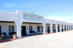
Amargosa Hotel, Death Valley Junction, California, by Kathy Alexander
Death Valley Junction, California – Intersection of SR 190 and SR 127, just east of Death Valley National Park. It still has many buildings.
Dolomite, California – California State Route 136 between Lone Pine and Keeler, California. Some old buildings and working mine. Located on private property with no access.
Dublin Gulch, California – In Shoshone, California, it has dugouts on the side of clay cliffs.
Dunmovin, California – South of Olancha, California. Has several old buildings.
Eagle Borax Works, California – South of Bennett’s Well, California. Low foundations only.
Echo, California – About four miles southwest of Lee, California. No remains. Requires 4-wheel drive.
Emigrant Springs, California – About seven miles northwest of Harrisburg, California. A few mining remnants.
Furnace, California – 6.5 miles northwest of Funeral Peak. No Remains.
Furnace Creek Inn, California – Furnace Creek, California. Is now an operating resort with a borax museum.
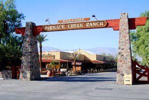
Furnace Creek Ranch entry in Death Valley National Park, California. Photo by Kathy Alexander.
Furnace Creek Ranch, California – Furnace Creek, California. Is an operating resort.
Gladstone Mine, California – See Kasson, California. Very little remains.
Gold Bar, Nevada – Near Rhyolite, Nevada – Mining remains, large mill foundations.
Gold Center, Nevada – Near Tonopah, Nevada. Foundations of a stamp mill and brewery.
Gold Hill Mining District, California
Goldbelt Spring, California – Was once located southeast of Teakettle Junction. Very little remains today. The actual spring is marked by an old dump truck.
Gold Valley, California – About ten miles south of Greenwater, California. – Very little tailings, leveled tent sites.
Grant, California – 1½ miles south of Olancha – A few old buildings.
Greenwater, California – About 27 miles southeast of Furnace Creek, California. – None at new Greenwater – a few at the original site of Kunze.
Greenwater Mining District, California – About 27 miles southeast of Furnace Creek, California. – Very little.
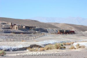
Harmony Borax Works by Dave Alexander
Harmony Borax Works, California – About a mile north of the Furnace Creek Visitor Center along Highway 190. – Ruins of the refinery, outbuildings, 20-mule team wagon.
Harrisburg, California – About two miles down the dirt road to Aguereberry Point off Highway 178. – Nothing of the townsite, but Aguereberry’s camp and mine remain.
Ibex Springs, California – About two miles south of Ibex Pass. – Buildings, mining ruins, stamp mill, smelter.
Inyo Mine, California
Johnnie, Nevada – 16 miles north of Pahrump, Nevada – Many, but located on private property, which allows no visitors.
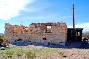
Kasson, California – About 12 miles northwest of the old town of Tecopa, California. – A few stone buildings.
Keane Springs, California – East of Furnace Creek, California. – A few mining ruins.
The Keane Wonder Mine in Death Valley National Park. Photo by Gianfranco Archimede, 2000.
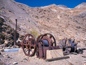
Keane Wonder Mine, California – East of Furnace Creek, California – Many; however, closed by the National Park due to instability as of this writing.
Kearsarge, California – High on Kearsarge Peak – None.
Keeler, California, is 11.5 miles southeast of New York Butte, California. It is a semi-ghost town with current residents.
Keynot, California – North of Beveridge, California – Mining remnants. Access should only be made by experienced backpackers.
Kunze, California – About 27 miles southeast of Furnace Creek, California. – Rock dugout, low rock walls, and mining remnants.
Laws, California – Four miles north of Bishop, California. – Is now a museum and historic site with many buildings.
Leadfield, California – On the Titus Canyon Road – Scattered mining remains, requires 4-wheel drive.
Lee, California/Nevada – At the California /Nevada state line, 30 miles south of Rhyolite. – Stone walls and foundations, mine shafts and tunnels, rubble.
Leeland, Nevada – About 17 miles south of Beatty, Nevada – A foundation and railroad debris.
Lila C/Old Ryan – 6.25 miles southwest of Death Valley Junction, California – Only tailings.
Little Lake, California – 38 miles south of Keeler on U.S. Route 395. – None.
Long Street Cabin, Nevada – National Wildlife Refuge in Amargosa Valley, Nevada – Reconstructed cabin.
Lookout City, California – About 15 miles southeast of Panamint Springs, California – Low walls, foundations, and mining ruins. Accessible by 4-wheel drive only.
Loretto, California – Off of Loretto Mine Road, southeast of Deep Springs, California. Remains include low stone walls, mining portals, and equipment.
Manse Ranch, Nevada – Near Pahrump, Nevada. – A ranch and dairy farm.
Manzanar, California
Mexican Camp, Nevada – 13 miles west of Rhyolite, Nevada – None
Monarch Canyon Mine, Nevada – West of Beatty about 17 miles – requires about a one-mile hike – Many – Mill, machinery, adits, foundations.
Monte Blanco, California
Noonday Camp, California
Olancha, California
Original, Nevada – Near Rhyolite, Nevada – None
Owenyo, California
Panamint City, California
Pioneer, Nevada – Near Rhyolite, Nevada – Some mining remains.
Reilly, California
Resting Springs, California – Area is dotted with mining remains.
Reward, California
Rose’s Well, Nevada – 17 miles south of Beatty – Ruins of the well
Ryan, California – 14.6 miles southeast of Furnace Creek Ranch, California – Numerous old buildings and mining remains.
Rhyolite Depot, which became a Casino at one point.
Rhyolite, Nevada – 5 miles west of Beatty – Many buildings
San Carlos, California
Sandspring, California
Schwab, California
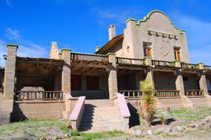
Scotty’s Castle, California – Esmeralda County, Death Valley National Park – Mansion and outbuildings
Shoshone Caves – See Dublin Gulch
Shoveltown, California
Skidoo, California
Springdale, Nevada – 10 miles north of Beatty, Nevada. – Mansion and outbuildings
Stirling, Nevada – 20 miles north of Pahrump, Nevada. – Scant remains.

The roofline of Scotty’s Castle shows the Spanish Moorish influences by Dave Alexander.
Stovepipe, California
Strozzi Ranch, Nevada – 16 miles northwest of Rhyolite, Nevada – Old cabin, shacks, fencing, fruit trees.
Swansea, California
Telluride, Nevada – 4.5 southeast of Beatty, Nevada – A few mine tailings
Transvaal, Nevada – 12 miles north of Rhyolite, Nevada – Mine dumps
Ubehebe, California
Wild Rose Camp, California
White Pot Mine, California
White Mountain City, California
Willow Creek, California – About ten miles south of Greenwater, California – Very little, tailings, leveled tent sites.
Zurich, California
Compiled by Kathy Alexander/Legends of America, updated March 2025.
See our Death Valley Photo Gallery HERE
Also See: