Ocate, New Mexico, is an unincorporated community and near ghost town in Mora County. In the northeast part of the state, this historic community is known for its Native American, Spanish, and Mexican influence and was once a popular site along the Santa Fe Trail.
Nomadic Indians, including the Navajo, Ute, Kiowa, Comanche, and Northern Apache, were some of this region’s earliest known inhabitants. These nomadic people camped, hunted, and traveled through the area but never built permanent structures. The Tewa, a more sedentary Puebloan Indian group, also lived in the area and probably built adobe homes. The word Ocate is said to be a Tewa word meaning, “port of the air” or “valley of the wind.” These terms are very accurate descriptions as the wind blows almost continually through this valley and is a powerful force much of the year.
Between 1540 and 1821, various Spanish expeditions explored the northeastern part of the state but did not pass through the Ocate-Mora area. Throughout the 1700s, the Ute, Comanche, and other tribes continually attacked Spanish settlements in north-central and northeastern New Mexico to drive away the intruders. Due to these attacks, the area was unattractive to the Spanish.
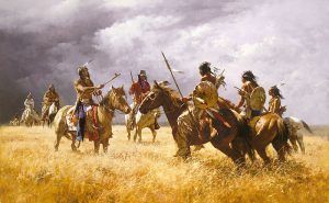
Comanche Warriors
After a series of battles between Spanish soldiers and various Indian bands, the Comanche signed a peace treaty with the Spanish in 1786. This treaty was largely honored by both sides, and after the danger of Indian attacks declined, several Spanish and Mexican colonists began to settle the area.
In the late 1700s, the first Spanish-European settlements were established in the Rio Grande Valley in north-central and eastern New Mexico in Trampas, Embudo, Picuris, and a few other outlying communities. All of them were largely self-sufficient since their links to Mexico were thousands of miles away. Though caravans traveled back and forth on Mexican trade routes, these trips were difficult and did not occur very often.
Within a few years of establishing the Mora Land Grant in 1835, Spanish-American rural farm villages sprang up wherever good land and water could be found in the foothill valleys. Within a few years, almost every river and tributary were dotted with small Spanish-American settlements.
In 1821 the Santa Fe Trail was blazed by William Becknell and became the major route into New Mexico from Missouri and Kansas. Numerous wagon trains, loaded with goods from the East, made the difficult journey to Santa Fe. The two major routes were called the Mountain Branch and the Cimarron Cutoff. The Mountain Branch followed the Arkansas River west through Kansas, turned southwest at Bent’s Fort in Colorado, and entered New Mexico at Raton. It then passed through Rayado, Ocate Crossing, Fort Union, Watrous and finally ended in Santa Fe.
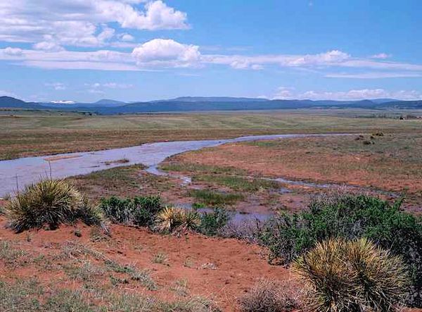
The Ocate Creek Crossing was a river crossing that was heavily used during and after the Civil War. General Stephen W. Kearny’s Army of the West crossed here in April 1846 and camped nearby. Several early travelers through the area briefly described the site in their journals or other writings. In his journal Lieutenant Abert noted that he and his party were forced to go two miles upstream, skirting the end of a high-walled mesa (now called Apache Hill), to reach a passable crossing place on the Ocate River. During Kearny’s crossing, his advance guard came in contact with several Mexicans from Mora who were said to be spies, and he sent them back to Mora with a message requesting a meeting with the alcalde.
“When we looked to our right hand, we saw another horizontal plain yet higher than the one we were traveling on and covered also with a bed of volcanic rock about five feet in thickness. Keeping close to the foot of this highest “mesa,” we reached the “Ocate;” as it is canoned, that is, is enclosed with high rocky walls, we were forced to go two miles upstream in order to reach the crossing.”
— Lieutenant James Abert, Army of the West, 1846
Afterward, the Army of the West was instrumental in clearing a wagon route across the Mountain Route of the Trail, making it more accessible to wagons and, thereby, increasing Trail traffic on this portion of the route.
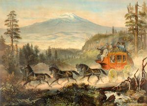
In 1866, on the south side of Ocate Creek stood a Barlow-Sanderson Company stage station called Calhoun’s Crossing. The seven-room station included a hotel. Reportedly, Wild Bill Hickok drove a stagecoach over Raton Pass for the stage company. There are no remains of the stage station today. The crossing continued to be used until the Santa Fe Trail closed after the railroad’s completion in 1879.
The crossing is located five to six miles east of the village of Ocate on a private ranch. Wagon ruts are still visible on both sides of the crossing. The crossing is 1-3/4 miles north of New Mexico Highway 120 on a ranch road, 14.5 miles west of Wagon Mound.
The site contains five rutted Trail segments and four creek crossings. Approximately 100 meters to the east of this site is the Calhoun Cemetery.
A secondary trail, called the Ocate Trail, went northwest from Ocate Crossing, through the town of Ocate into Manueles Canyon to Black Lake and on to Taos. The town of Ocate was the exchange point for the merchandise and goods that the wagons carried. Some goods would be sent on the Ocate Trail to Taos, and the rest would remain on the wagons going to Santa Fe. From Ocate, the route to Santa Fe continued between Cerro Pelon and El Corral de los Apaches and then turned south to Fort Union and Las Vegas.
The Spanish treaty with the Commanche continued to be honored by both sides until the Americans took control of the area in 1846. At that time, the change shattered the fragile, peaceful relationship established among the frontier peoples. Immediately there was a great deal of hostility toward the Americans, and the Taos Revolt began in 1847, and Indian raids also increased on travelers and settlers. The tension rapidly spread throughout northern New Mexico. Seven American Santa Fe traders were killed in Mora, and the American Army had to launch several attacks before finally subduing a revolt in Mora.
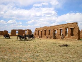
Fort Union was established in 1851 to quell the Indian attacks and curb uprisings by local Hispanic populations against the newly established American presence in the region. In addition to keeping the peace in northern New Mexico, the fort became an ever-ready market for hay, grain, fruit, vegetables, and livestock produced by the local Spanish-American population. Some of these local people also found employment on the post. Over time, more outsiders, Anglo-Americans, and European immigrants, either purchased land from Spanish-American residents or squatted on the Mora Grant land near the fort.
Despite the fort’s presence, the situation worsened in the 1860s because many of the army units stationed there were ordered to move to join the Union armies of the East during the Civil War.
By this time, the region’s economy was based on the intensive farming of small agricultural plots and raising livestock, primarily sheep, which grazed on the common lands of the grant. Some of the young men, known as cibolerns, hunted buffalo on the Plains each fall; others, known as Comancheros, developed trade networks with the Comanche, depending at first on surplus products from the villages, and later expanding to all manner of goods, including stolen Texas cattle. This latter practice caused the eventual suppression of this form of trade in the late 1870s by Anglo ranchers whose stock was rapidly being depleted by Comanche raids.
Ocate gained a post office on January 10, 1870.
For a period of time, Indian raids limited the profitability of the sheep business in northeastern New Mexico. Eventually, however, with the Indians subdued following their defeat in the Red River War of 1874, new economic ventures were considered safe. The Atchison, Topeka, and Santa Fe Railroad came into the region in 1879, shutting down traffic on the Santa Fe Trail.
Much of Mora County became an important stock-raising region, with large herds of sheep and, later, cattle. Despite Ocate being an important stop on the railroad for agricultural trade, the railroad bringing more tourism to the west, Ocate soon experienced a sharp population decline.
Fort Union was no longer needed with the area being much quieter and therefore was abandoned in 1891.
As time passed, the grant lands were broken up, drought hit the area, sheep raising became less profitable, and cattle ranchers began to move into former sheepherding rangeland. Ranchers came to realize that cattle offered bigger and quicker profits and turned their efforts in that direction. The sheep ranges were gradually depleted and supported fewer sheep.
In the early 20th century, many people living in the Ocate area continued to survive by farming and raising sheep. Farms grew multiple crops, including wheat, Indian corn, American corn, oats, peas, beans, potatoes, pumpkins, squash, and various fruits such as apples, cherries, peaches, plums, and pears.
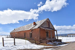
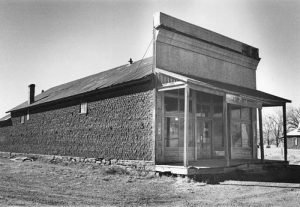
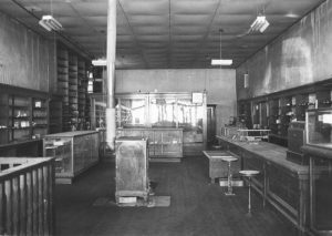
In 1906, French Immigrant Nathan Weil built a crossroads store in Ocate that provided various goods. At that time, Ocate supported three other mercantile establishments and several other types of businesses. Weil also served as the village postmaster and notary public. Within no time, the store served as the region’s political and social center. As his business interests grew and prospered, he also ran large numbers of livestock on the fertile pastures of Mora County and became a leading trader in cattle, sheep, and wool. Diversifying further, he was also an organizer and director of local banks in the nearby towns of Las Vegas, Springer, and Wagon Mound.
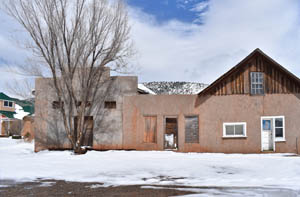
In 1938, after 40 years of merchandising at Ocate, Weil closed the store during the depths of the Great Depression and devoted his remaining years to his ranching interests. The store building remained unused until a few years after World War II when purchased by a former commercial rival, John P. Strong, as a replacement for another store that had recently burned. Strong was a descendant of one of the first Anglo families to settle at Ocate. The Strongs had operated other mercantile enterprises at various locations in Mora County for years. The Strongs continued to operate the business until it was sold to a long-time employee named Donaciano Mondragon in 1960. Mondragon then continued the operation for another 14 years until it finally closed in 1974.
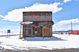
The adobe brick building topped by a corrugated metal pitched roof still stands in Ocate and was added to the National Register of Historic Places in 1979. The building is located at the intersection of State Highways 21 and 120.
Across the street is another historic property — the Narciso Valdez House. Built between 1895 and 1898, the one-and-a-half-story adobe house features Queen Anne style, particularly in its interior. It was listed on the National Register of Historic Places in 1980.
By the 1930s, several men from northern New Mexico had left their villages to seek work in the Colorado sugar beet fields or commercial ranches in Montana, Utah, or Wyoming.
Today, this small village, overshadowed by the rocky slopes of Gallinas Mesa, consists of a scattering of buildings strung along the south bank of Ocate Creek for a mile or more. It still supports a post office and a Catholic Church.
Ocate is northwest of Wagon Mound, New Mexico, at the intersection of State Roads 120 and 442. The cemetery is northeast of the intersection, south of the housing, in the middle of the field.
© Kathy Weiser/Legends of America, April 2021
Also See:
Tales & Trails of the American Frontier
Sources:
National Register of Historic Places – Strong Store
National Register of Historic Places – Trail Ruts
New Mexico Archaeology
University of New Mexico


