By Henry Howe in 1857
The western coasts of North America were first partially explored by the Spaniards in the century succeeding the discovery of America. The English later followed their explorations. In 1578, Sir Francis Drake ranged this coast from 38 to 48 degrees. This region was called New Albion by the English.
The name “Oregon” is derived from “Oregano,” the Spanish term for wild marjoram. Up until the latter part of the 18th century, little was known about Oregon’s coast. However, following the final voyage of the famous navigator Captain Cook, news of the abundant sea otters, beavers, and other valuable furs available on the northwest coast of America spread to civilized nations. The high prices these furs could fetch in China generated excitement comparable to the discovery of a new gold region. As a result, many people rushed to partake in this lucrative trade. By 1792, it was reported that 21 vessels, primarily American but also under other flags, were operating along the Oregon coast and trading with Native Americans. Until that time, the Columbia River—the most significant river flowing into the Pacific from America—was little known.

The rocky Oregon Coast.
Up to this period, nothing was positively known of the Columbia River, the most significant stream that enters the Pacific from America. The Spanish navigator, Bruno de Heceta, in August 1776, first saw the opening through which its waters discharge into the ocean, and it was accordingly marked on the Spanish charts as the mouth of the river San Roque. In July 1788, Lieutenant John Meares of the British Navy examined it and concluded that no river existed; yet this was the claim the British later asserted to assert possession by the right of discovery. Captain George Vancouver, another British navigator who explored the coast in 1792, confirmed this opinion. He stated that from Cape Mendocino, in California, to the Straits of Fuca, the southern boundary of Vancouver’s Island, there was not a single harbor, “the whole coast forming one compact and nearly straight barrier against the sea.”

Columbia River.
On May 7, 1792, Captain Robert Gray of the ship Columbia of Boston, Massachusetts, discovered and entered the river, which he named after his vessel. He was, in reality, the first person who established the fact of the existence of this great river, and this gave the United States the right to the country drained by its waters by virtue of discovery.
In the autumn of 1792, Sir Alexander Mackenzie, with an exploring party, left Fort Chipewyan, on Athabasca Lake, midway between Hudson’s Bay and the Pacific Ocean, in the high northern latitude of 59 degrees, and reached the Pacific Ocean in July 1793, being thus the first white man who had ever crossed the American continent in its widest part. His route appears to have been farther north than the current northern boundary of Oregon.
In 1804-05, Lewis and Clark explored the country from the mouth of the Missouri River to that of the Columbia River. This exploration of the Columbia River, the first-ever made, constituted another ground for the claim of the United States to the country. In 1806, the British North West Fur Company established a trading post on Fraser’s Lake, the first settlement of any kind by British subjects west of the Rocky Mountains. Other posts were established by them soon after in that region, which was then given the name of New Caledonia.
In 1808, the Missouri Fur Company, through their agent, Andrew Henry, established a trading post on the Lewis River, a branch of the Columbia. It was the first establishment of civilized people in what is now Oregon. An attempt was made that year by Captain William Smith of the Albatross, of Boston, to found a trading post on the south bank of the Columbia River, 40 miles from its mouth. It was abandoned in the same season as that of Andrew Henry’s in 1810.

John Jacob Astor.
In 1810, John Jacob Astor, a German merchant from New York, who had amassed an immense fortune through commerce in the Pacific and China, formed the Pacific Fur Company. His first objectives were to focus on the company, the fur trade in the unsettled parts of America, and the supply of merchandise to the Russian fur-trading establishments in the North Pacific. For these purposes, posts were to be established on the Missouri River, the Columbia River, and the vicinity. These posts were to be supplied with the merchandise required for trading by ships from the Atlantic coast or across the country via the Missouri River. A factory was to be founded on the Pacific coast to receive this merchandise, distribute it to the different posts, and, in turn, receive furs from them, which were to be sent by ships to Canton, China. Vessels were also to be sent from the United States to the factory with merchandise, which would be traded for furs. These furs would then be sent to Canton, where they would be exchanged for tea, silk, and other goods, which would be distributed in turn in Europe and America.
This enterprise, at the time, appeared practicable. The only party from whom any rivalry could be expected was the British North West Fur Company, whose means were far inferior to those of Astor. From motives of policy, he offered them one-third interest, which they declined, secretly intending to forestall him. Having matured his scheme, John Jacob Astor engaged partners, clerks, and voyageurs, most of whom were Scotchmen and Canadians, previously in the North West Fur Company service. Wilson P. Hunt of New Jersey was chosen as the chief agent of operations in Western America.
In September 1810, the ship Tonquin, Captain Samuel Thorn, left New York for the mouth of the Columbia River with four of the partners, Alexander McKay, Duncan McDougall, and David and Robert Stuart, all British subjects, with clerks, voyageurs, and mechanics. In January 1811, the second detachment, with Wilson Hunt, Robert McClellan, Kenneth McKenzie, and Ramsey Crooks, also left New York to go overland by the Missouri River to the same point, and in October 1811, the ship Beaver, Captain Cornelius Sowles, with several clerks and attaches, left New York for the North Pacific. Before this, in 1809, John Jacob Astor had dispatched the Enterprise under Captain John Ebberts to observe the Russian settlements and to prepare the way for future settlements in Oregon. He also sent an agent to St. Petersburg in 1811, who obtained from the Russian American Fur Company the monopoly on supplying their posts in the North Pacific with merchandise and receiving furs in exchange.
In March 1811, the Tonquin arrived at the Columbia River. Soon after, they commenced erecting their factory or depot building on the south bank, a few miles inland, named Astoria. In June, the Tonquin, under the command of Alexander McKay, sailed north to arrange a trade with the Russians. In July, the Astorians were surprised by the appearance of a party of the North West Fur Company, under David Thompson, who had come overland from Canada to forestall them in the occupation of the mouth of the Columbia; but had been delayed too late for this purpose, in seeking a passage through the Rocky Mountains, and had been obliged to winter there. David Thompson was accompanied on his return by David Stuart, who founded the trading post called Okonogan.
At the beginning of 1812, the detachment of Wilson Hunt came into Astoria in parties and a wretched condition. They had been over a year in coming from St. Louis, Missouri; they had undergone extreme suffering from hunger, thirst, and cold in their wanderings that winter, through the dreary wilderness of snow-clad mountains, from which, and other causes, numbers of them perished. In May 1812, the Beaver brought the third detachment under Mr. Clarke and arrived at Astoria. They brought a letter that had been left at the Sandwich Islands by Captain Ebbets of the Enterprise, containing the sad intelligence that the Tonquin and her crew had been destroyed by Indians near the Straits of Fuca the June preceding.
In August 1812, Wilson Hunt, leaving Astoria in the charge of Duncan McDougall, embarked in the Beaver to trade with the Russian posts, which was to have been done by the Tonquin. He was successful and effected a highly advantageous arrangement at Sitka with Baranof, Governor of Russian America; took in a rich cargo of furs, and dispatched the vessel to Canton via the Sandwich Islands, where he, in person, remained, and in 1814, he returned to Astoria in the Peddler, which he had chartered, and found that Astoria was in the hands of the North West Fur Company.

Fort Astoria, Oregon.
When Hunt left in the Beaver, a party was dispatched to establish a trading post on the Spokane. Ramsey Crooks, Robert McClellan, and Robert Stuart set out and crossed overland to New York with an account of what had been done. The trade was, in the meantime, very prosperous, and a large quantity of furs had been collected at Astoria.
In January 1813, the Astorians learned from a trading vessel that a war had broken out between England and the United States. A short time after, John Mactavish and Joseph Laroque, partners of the North West Company, arrived at Astoria. Duncan McDougall and Kenneth McKenzie, both Scotchmen, were the only partners there, and they unwisely agreed to dissolve the company in July. Stuart and Clarke, at the Okonogan and Spokane posts, opposed this, but it was finally agreed that if assistance did not soon arrive from the United States, they would abandon the enterprise.
Mactavish and his followers of the North West Company again visited Astoria, where they expected to meet the Isaac Todd, an armed ship from London, which had orders “to take and destroy everything American on the northwest coast.” Notwithstanding, they were hospitably received and held private conferences with Duncan McDougall and Kenneth McKenzie, the result of which was that they sold out the establishment, furs, and supplies of the Pacific Fur Company in the country, to the North West Company, for about $58,000. That company was thus enabled to establish itself in the country.
Thus ended the Astoria enterprise. Had the directing partners on the Columbia River been Americans instead of foreigners, it is believed that they would have withstood all their difficulties, notwithstanding the war. The sale was considered disgraceful, and the conduct of Duncan McDougall and Kenneth McKenzie in that sale and subsequently was such as to raise suspicions of their motives. Yet, they could not have been expected to engage in hostilities against their countrymen and old friends.
The British renamed Astoria Fort George. From 1813 to 1823, few, if any, American citizens entered the countries west of the Rocky Mountains. Nearly all the trade of the Upper Mississippi and Missouri Rivers was carried on by the American Fur Company, of which Astor was the head, and by the Columbia Fur Company, formed in 1822, composed mainly of persons who had been in the service of the North West Company, and were dissatisfied with it. The Columbia Fur Company established posts on the upper waters of the Mississippi River, the Missouri River, and the Yellowstone, which were transferred, in 1826, to the North American Company on the junction of the two bodies. About this time, the overland trade with Santa Fe, New Mexico commenced, with caravans passing regularly every summer between St. Louis and that place. In 1824, Ashley of St. Louis re-established commercial communications with the countries west of the Rocky Mountains and built a trading post on Ashley’s Lake in Utah.
Hudson’s Bay Company at Fort Colville, Oregon, 1860.
These active proceedings of the Missouri Fur Company traders stimulated the American Fur Company to send its agents and attaches beyond the Rocky Mountains, although they built no posts. In 1827, Joshua Pilcher of Missouri went through the South Pass with 45 men and wintered on the headwaters of the Colorado River in what is now the northeast part of Utah. The following year, he proceeded northward along the base of the Rocky Mountains. There, he remained until the spring of 1829, when he descended Clark River to Fort Colville, then recently established at the Falls by the Hudson’s Bay Company, which had, a few years previous, absorbed and united the interests of the North West Company. He returned to the United States through the long and circuitous far northward route of the Upper Columbia, the Athabasca, the Assiniboin, the Red River, and the Upper Missouri River. But little was known of the countries through which Pilcher traversed, previous to the publication of his concise narrative. The account of the rambles of J.O. Pattie, a Missouri Fur Company trader through New Mexico, Chihuahua, Sonora, and California, threw some light on the geography of those countries. In 1832, Captain Bonneville of the U.S. Army, while on furlough, led a party of 100 men from Missouri over the mountains. He spent more than two years on the Columbia and the Colorado Rivers hunting, trapping, and trading.

Nathaniel Jarvis Wyeth.
At about the same time, Captain Nathaniel Wyeth of Massachusetts attempted to establish commercial relations with the countries on the Columbia River, to which the name Oregon began to be applied universally. His plan was similar to that of John Jacob Astor’s, with the additional scheme of transporting the salmon from the Oregon rivers to the United States. He made two overland expeditions to Oregon, established Fort Hall as a trading post in present-day Idaho, and led another, mainly for fishing purposes, near the mouth of the Willamette River. This scheme failed due to the rivalry of the Hudson’s Bay Company, which founded the counter-establishment at Fort Boise. Offering goods to the Indians at lower prices than Wyeth could afford compelled him to desist, and he sold out his interests to them. Meanwhile, a brig he had dispatched from Boston arrived in the Columbia and returned with a cargo of salted salmon; however, the results were not auspicious, and the enterprise was abandoned.
The American traders, being excluded by these and other means from Oregon, mainly confined themselves to the regions of the headwaters of the Colorado River and the Utah Lake, where they formed one or two small establishments and sometimes extended their rambles as far west as San Francisco and Monterey, California. The number of American hunters and trappers thus employed west of the Rocky Mountains seldom exceeded 200, where, during the greater part of the year, they roved through the wilds in search of furs which they conveyed to their places of rendezvous in the mountain valleys. They bartered with them to the Missouri traders.
About the time of Nathaniel Wyeth’s expedition, the earliest wave of settler emigration from the United States to Oregon occurred. The first of these was founded in 1834 in the Willamette Valley by a group of Methodists who traveled by sea under the direction of the Reverends Jason Lee and Cyrus Shepherd. In that valley, a few retired servants of the Hudson’s Bay Company were then residing and engaged in herding cattle. The Congregationalists or Presbyterians planted colonies two or three years later, in the Walla Walla and Spokane areas, with the Reverends Samuel Parker, Henry Spalding, William Gray, Elkanah Walker, Cushing Eells, John Smith Griffin, and Dr. Marcus Whitman as missionaries.
In all of these places, mission schools were established for the instruction of the natives, and in 1839, a printing press was started at Walla Walla, Washington, where the first sheets were printed on the Pacific side of the mountains north of Mexico. On it, books were printed from types set by native compositors. The Roman Catholics from Missouri soon after founded stations on the Clark River.
In approximately 1837, the American people began to show a deep interest in the United States’ claims to Oregon, and societies were formed for emigration. Petitions from them and other sources were presented to Congress to either make a definite arrangement with Great Britain, the other claimant, or take immediate possession of the country. Each year, from 1838 to 1843, small parties emigrated overland from Missouri to Oregon, enduring considerable hardship along the route. At the close of 1842, the American citizens there numbered about four hundred. Relying upon the promise of protection held out by the passage of the bill in February 1843 by the U. S. Senate for the immediate occupation of Oregon, about 1,000 emigrants, men, women, and children, assembled at Westport, on the Missouri frontier in the succeeding June, and followed the route up the Platte River, and through the South Pass, surveyed the previous year by Charles Fremont; thence by Fort Hall, Idaho to the Willamette Valley, where they arrived in October, after a laborious and fatiguing journey of more than 2,000 miles. Others soon followed, and by the close of the next year, over 3,000 American citizens had arrived in Oregon.

Mountain Man.
By the treaty for the purchase of Florida in 1819, the boundary between the Spanish possessions and the United States was fixed on the northwest at 42 degrees latitude, the present northern line of Utah and California; by this, the United States succeeded to the title to Oregon as Spain may have derived, by the right of discovery through its early navigators. In June 1846, all the difficulties concerning Oregon, which had once threatened war, were settled by a treaty between the two nations. In general terms, the treaty established the northern boundary; British subjects were allowed the free navigation of the Columbia River, and the Hudson’s Bay Company and all British subjects were to be continued in possession of whatever land or property they at that time held in Oregon.
The principal obstacle to a previous settlement had been the company’s influence. The English people at large knew little of the country and took but slight interest in it. The British, first through the North West Company and then through the Hudson’s Bay Company (into which the former became absorbed), from 1814 to 1840, had enjoyed the almost exclusive use of Oregon. The Hudson’s Bay Company received from the British government, to the exclusion of all other British subjects, the exclusive right to trade west of the Rocky Mountains, where the fur-bearing animals were more abundant than in any other part of the world.
The Company’s constitution aims to secure knowledge and prudence in council, readiness, and exactness in execution. Their treatment of the Indians admirably combined policy and humanity. Ardent spirits were prohibited from being sold to them; schools for the instruction of the Indian children were established at each of the trading posts, and hospitals for the sick; missionaries of various sects were encouraged and fostered, and all emigrants from the United States and elsewhere were treated with the utmost kindness and hospitality. But, no sooner did any of them attempt to hunt, trap, or trade with the natives than the competition of the body was turned against him, and he was compelled to desist. As the fur trade declined, the company shifted its focus to agriculture, lumbering, fishing, and other related pursuits.
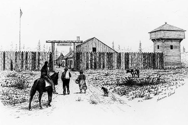
Fort Nasqually, Washington.
In 1841, the coast of Oregon was visited by the ships of the United Exploring Expeditions under Lieutenant Charles Wilkes. He arrived in the sloop of war Vincennes, off the mouth of the Columbia River, on April 27, but, finding it hazardous to attempt the entrance, he sailed to the Straits of Fuca, the southern boundary of Vancouver’s Island, and anchored in Puget’s Sound, near Fort Nasqually, Washington from which he dispatched several surveying parties into the interior. One of these crossed the great westernmost range of mountains to the Columbia River and, having visited the British trading posts of Okonogan, Colville, and Walla Walla, returned to Nasqually. Another party proceeded southward to the Cowelitz, a stream running south and emptying into the Columbia River about forty miles from the ocean. From the mouth of the Cowelitz, they went up the Columbia to Walla Walla, and down again to the ocean. In the meantime, other parties were engaged in surveying the coasts and harbors on the Pacific, the Straits of Fuca, and Admiralty Inlet, particularly in exploring the valleys of the Willamette, emptying into the Columbia, and of the Sacramento River of California. During these duties, the sloop of war Peacock was lost on the bar at the mouth of the Columbia River, but the crew, instruments, and papers were saved.
At that time, Wilkes estimated the population to be: of Indians, 19,199; Canadians and half-breeds, 650; and the citizens of the United States, 150. The Hudson’s Bay Company had 25 forts and trading stations in Oregon. Dr. John McLoughlin, the company’s executive officer, was kind to the American settlers and, although a Catholic, was noted for his hospitality to the Methodist and Presbyterian missionaries. The Hudson’s Bay Company charter prevented them from engaging in agriculture; its officers, agents, and servants organized another company for this purpose, with a capital of two million, called the Puget Sound Company. They began by importing large quantities of stock from California and some of the finest breeds from England. They entered farming on an extensive scale. Almost all their trading establishments were later converted into agricultural ones, and they almost entirely supplied their stations, forts, and Russian ports in the north with wheat, butter, and cheese.
Whitman Mission.
Among the most notable incidents in Oregon’s history was the Cayuse War, which occurred in the winter of 1847-48. It grew out of these circumstances: The Reverend Dr. Marcus Whitman, a Presbyterian missionary, who, besides his religious duties, had established a fort and trading post in the Walla Walla Valley and employed large numbers of Indians and emigrants in agriculture. Many of these Cayuse Indians, under his guidance, had become partially civilized and were skilled farmers. He was eminent for his hospitality to the newly arrived and exhausted emigrants and was popular with all. His lady was also remarkable for her kindness and, at that time, was administering a vaccine for measles to the Indians, which was then extensively prevalent among them. Many died of the disease; they became suspicious that they were poisoned by the medicines given to them by the Whitmans. On November 29, 1947, at about noon, the Indians rushed into the fort, murdered Dr. Marcus Whitman and his wife, and 13 others, took 61 people prisoners, and burnt the fort and houses of the settlement. Upon receiving the news in the Willamette settlements, troops were raised, the Indians were defeated in three battles, and their villages and provisions were destroyed. The prisoners were eventually released through the praiseworthy efforts of Peter Sken Ogden, chief factor of the Hudson’s Bay Company.
Oregon was organized as a territory in 1848. It has an average width of approximately 680 miles east to west and 500 miles north to south, for a total area of approximately 340,000 square miles. It is divided into three natural sections:
The first section lies between the Pacific Ocean and the President’s Range, also known as the Cascade Mountains. The Cascade Range runs parallel with the sea coast, the whole length of the territory, and is continued through California under the name of the Sierra Nevada. It rises in many places to conical peaks, reaching heights of 12,000 to 14,000 feet, or over two miles above sea level. The distance from the seashore to this chain is from 100 to 150 miles; there were a few mountain passes, but they were difficult and could only be attempted late in the spring and summer. The climate of this section is mild throughout the year, neither experiencing the extreme cold of winter nor the heat of summer. The prevailing winds in the summer are from the northward and westward, and in winter, the southward, westward, and southeast are tempestuous. Winter is typically considered to last from December to February. Rains usually begin in November and last until March, although they are not heavy but relatively frequent. Snow sometimes falls, but it seldom lies for over three days. The frosts are early, occurring in the latter part of August; this, however, is to be accounted for by the proximity of the mountains. Fruit trees blossom early in April.
The soil, in the northern parts, varies from a light brown loam to a thin vegetable earth, with gravel and sand as a subsoil; in the middle parts, from a rich heavy loam and unctuous clay to a deep heavy black loam, on a caprock; and in the southern (the Willamette Valley) the soil is generally good, varying from a black vegetable loam to decomposed basalt, with stiff clay, and portions of loose gravel soil. The hills are generally composed of basalt, stone, and slate. Between the Umpqua River and the southern boundary, the rocks are primitive, consisting of slate, hornblende, and granite, which produce gritty, poor soil. However, there are some places with rich prairie, covered with oaks. It is, for the most part, a well-timbered country. It is intersected by spurs or offsets from the Cascade Mountains, which render its surface much broken; these are covered with dense forest. The timber consists of pines, firs, spruce, oaks (red and white), ash, arbutus, arbor vitae, cedar, poplar, maple, willow, cherry, and tew, with a close undergrowth of hazel, rubus, and roses. The richest and best soil is found on the second or middle prairie and is best suited for agriculture; the high and low prairies are excellent for pastureland. The climate and soil are admirably adapted for all kinds of grain—wheat, rye, oats, barley, peas, etc. Indian corn does not thrive in any part of this territory or the Mississippi Valley. Many fruits appear to do well, particularly apples and pears. Vegetables grow exceedingly well and yield most abundantly.
The Second or Middle Section is between the Cascade and Blue Mountain Ranges. The Blue Mountains are irregular in their course and occasionally interrupted but generally run in a northerly direction; they commence in the Klamet range, near the southern boundary of the territory; the Saptin or Snake River breaks through them at the junction of the Kooskooskee River, and branch of it in hills of moderate elevation, until they again appear on the north side of the Columbia River, above the Okonogan River, passing in a northern direction, until they unite with the Rocky Mountains. The climate of the middle section is variable; during the summer, the atmosphere is much drier and warmer, while winter is significantly colder than in the western section. Its extremes of heat and cold are more frequent and greater; the mercury, at times, falls as low as minus 18 degrees in winter and rises to 108 degrees in the shade of summer; the daily difference in temperature is about 40 degrees. It has, however, been found extremely salubrious, possessing a pure and healthy air. No dews fall in this section. The soil is, for the most part, a light sandy loam; in the valleys, a rich alluvial; and the hills are generally barren. The surface is about 1,000 feet above the level of the western section and is generally a rolling prairie country. In the center of this section, and near and around the junction of the Saptin or Snake and Columbia Rivers, is an extensive rolling country well adapted for grazing. South of the Columbia River and extending to the southern boundary of the territory, it is destitute of timber or wood unless the wormwood (artemisia) may be so-called. However, portions of it might be advantageously farmed.
The Third, or East Section, is between the Rocky and the Blue Mountains. The Rocky Mountains commence on the Arctic coast and continue an almost” unbroken chain until they merge with the Andes of South America. That part forming the eastern boundary of Oregon, extending north from the Great South Pass at the Committee’s Punch-bowl Pass, forms an almost impenetrable barrier; the few passes between were very difficult and dangerous. The climate of the eastern section is highly variable. Every day brings all the changes incident to spring, summer, autumn, and winter. There are places where small farms might be located, but they are few. The soil is rocky and broken, presenting an almost unbroken barren waste. Stupendous mountain spurs traverse it in all directions, affording little level ground. Snow lies on the mountains, nearly, if not quite, throughout the year. It is exceedingly dry; rains seldom fall, and but little snow. This country is partially timbered, and the soil is much impregnated with salts.

Columbia River below the Cascades.
The Columbia is the great river of the territory, nearly all the others being its tributaries. Its northern branch, Clark River, from its source in the Rocky Mountains to near Fort Colville, is bounded by lofty wooded mountains. At Walla Walla, it unites with its other branch, the Lewis River, which is not navigable even by canoes. At the junction, the Columbia River is 1,286 feet above the ocean and nearly three-fourths of a mile wide: it here takes its last turn westward, pursuing a rapid course for 180 miles previous to passing through the Cascade Range in a series of falls and rapids that obstruct its flow and form during floods and insurmountable barriers to boat navigation, which difficulties were later overcome by portages. Locks and canals would eventually be used. From there, there is still water navigation for forty miles when rapids again obstruct its course. Thence to the ocean, 120 miles, it is navigable for vessels of twelve feet draught at the lowest water stage. To the south of the Columbia River, the only three rivers of note are the Umpqua, Rogue, and Klamath.
The character of the great rivers is peculiar — rapid and sunken much below the level of the country, running as it were in trenches, and exceedingly difficult to get at in many places, owing to the steep basaltic walls. During high water, they are in many places confined by Dalles (narrows), which back the water, covering the islands and tracts of low prairie, giving the appearance of extensive lakes. The Dalles of the Columbia, 84 miles below Walla Walla, is a noted place where the river passes between vast masses of rock. Oregon is well-watered by springs, rivulets, and lakes.
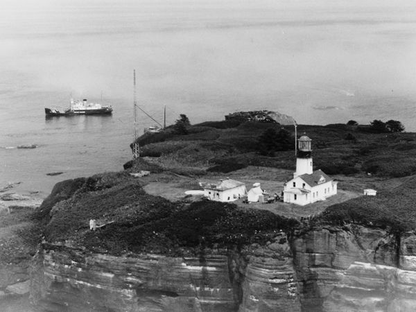
Entrance to the Strait of Juan de Fuca.
Sand brought down by the rivers more or less obstructs the harbors. The mouth of the Columbia River, formerly considered very dangerous from this cause, later proved less so than was supposed, and vessels of 16 feet draught frequently entered and departed safely without pilots or buoys. The harbors of the Strait of Fuca are equal to any in the world, among which Puget’s Sound on Admiralty Inlet, the bay running south from the strait, is noted.
It is almost impossible to understand the extensive rivers and coastal fisheries. They all abound in salmon of the finest flavor, which run twice a year, beginning in May and October, and appear inexhaustible; the whole population lives upon them. The Columbia River produces the largest and probably affords the most significant numbers. There are a few of the branches of the Columbia that the spring fish do not enter, but they are plentifully supplied in the fall. The great fishery of the Columbia is at the Dalles, but all the rivers are well supplied. The last one on the northern branch of the Columbia is near Colville, at the Kettle Falls, but salmon are found above this in the river and its tributaries. In the rivers and sounds are found several kinds of salmon, salmon-trout, sturgeon, cod, carp-sole, flounders, ray, perch, herring, lamprey-eels, and a smelt called “skroic,” in great abundance; also large quantities of shellfish, including crabs, clams, oysters, and mussels, which are all used by the natives, and constitute the greater proportion of their food. Whales, in numbers, are found along the coast and are frequently captured by the Indians in and at the mouth of the Straits of Juan de Fuca.
An abundance of game exists, such as elk, deer, antelope, bears, wolves, foxes, muskrats, martins, beavers, and a few grizzly bears, which the Canadians eat. No game is found in the middle section, or that designated by the rolling prairie. In the eastern section, the buffalo is encountered. The fur-bearing animals are decreasing in numbers yearly; indeed, it is very doubtful whether they are sufficiently numerous to repay the expense of hunting them. By the mid-1800s, the Hudson’s Bay Company had almost an exclusive monopoly on this business, though it had decreased due to the hunting of beavers without regard to the season. This was not, however, the case to the north, in the British possessions, where the company was left to exercise its own rule and prevent the indiscriminate slaughter of either old or young out of the proper season. In the spring and fall, the rivers are covered with geese, ducks, and other waterfowl.

Game hunters.
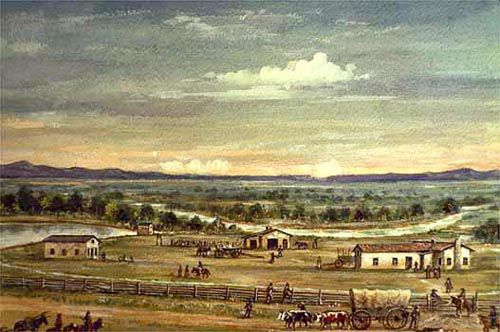
Fort Vancouver, on the Columbia River, and 90 miles from the ocean, was the principal seat of the British fur trade and the headquarters of the Hudson’s Bay Company. It was a large stockade enclosing many buildings. Here was a fine farm, workshops, mills, and a school. Astoria, or Fort George, is eight miles from the mouth of the Columbia River and had but two or three buildings.
In this neighborhood are forests of pine, which have long been noted for their beauty and size. Lieutenant Charles Wilkes spoke of them: “Short excursions were made by many of us in the vicinity, and one of these was to visit the primeval forest of pines in the rear of Astoria, a sight well worth seeing. Mr. Drayton took a camera lucida drawing of one of the largest trees. It conveys a good sense of the thick tree growth and is quite characteristic of this forest. The soil this timber grows in is rich and fertile, but the obstacles to the agriculturist are almost insurmountable. The largest tree in the sketch was 39 feet six inches in circumference, eight feet above the ground, and had a bark eleven inches thick. The height could not be ascertained, but it was thought to be upward of 250 feet, and the tree was perfectly straight.” These trees, for at least 150 feet, are without branches. In many places, those that have fallen present barriers to the vision, even when the traveler is on horseback. Between the old forest trees lying prone, the tender and small twig, beginning its journey, can be seen to a fantastic height.
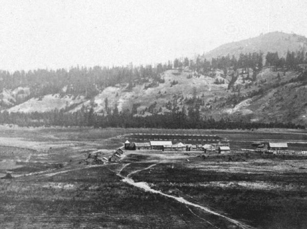
Fort Walla Walla, or the Nez Perce, was on the south side of the Columbia River, ten miles below the mouth of the Lewis River. Fort Colville was on the south side of the Clark River, above Fort Okonogan. Okonogan and Spokane, located on the Spokane River, were the first fur-trading establishments of John Jacob Astor’s company in Oregon. The mountains in the view are part of the Blue Mountains, which rise to great heights. Later, Fort Okonogan would be maintained as a supply depot, and the Hudson’s Bay Company had various other trading posts throughout the country.
The American settlements in Oregon were primarily located in the western section of the state, concentrated in the beautiful and fertile Willamette River Valley. Oregon City is 2,300 miles from St. Louis, on the east bank of the Willamette, just below the falls, at the head of navigation, and about 18 miles from the mouth of the river. It was in the largest town in Oregon in the 1850s. In 1848, it consisted of one Methodist and one Catholic church, a public library, one newspaper printing office, one female boarding school, one day school, five stores, three hotels, two flour mills, and two sawmills, with a population of 650 inhabitants. Later, it increased in size. Milwaukie, Plymouth, Portland, and Salem, on the Willamette River, and Cascade on the Columbia River, were promising places. In 1848, the total white population was approximately 9,000; by 1850, it had likely doubled, partly due to the impact of the California gold discovery.
By Henry Howe, 1857 – Compiled and edited by Kathy Alexander/Legends of America, updated November 2025.
About the Author and Article: This article was a chapter in Henry Howe’s book Historical Collections of the Great West, published by George F. Tuttle, of New York, in 1857. Henry Howe (1816 -1893) was an author, publisher, historian, and bookseller. Born in New Haven, Connecticut, his father owned a popular bookshop and was a publisher. Henry would write histories of several states. His most famous work was the three-volume Historical Collections of Ohio. As he collected facts for his writing, he also drew sketches, which helped create interest in his work. The article as it appears here is not verbatim, as it has been edited for the modern reader; however, the content remains essentially unchanged.
Also See: