
Southwest Texas Road Map, 1850.
The San Antonio-El Paso Road, also known as the Lower Emigrant Road or Military Road, was a crucial trade route between the Texas cities of San Antonio and El Paso from 1849 to 1882. The road carried mail, freight, and passengers by horse and wagon across the Edwards Plateau and the dangerous Trans-Pecos region of West Texas.
The Republic of Texas was annexed to the United States as the 28th state on December 29, 1845. The Treaty of Guadalupe Hidalgo, signed in 1848, established the Texas/Mexico border as the Rio Grande.

Republic of Texas, 1844.
The need to survey and develop transportation links between San Antonio, the Gulf Coast, El Paso, and Chihuahua, Mexico, became a high priority for the U.S. Army. With the discovery of gold in California the following year, the need for immigrant roads and commercial freighting routes from Texas’ Gulf Coast to El Paso and points west provided additional impetus for the Army to establish and protect routes between Texas’ major cities and the Gulf coast.
During the early years of Texas statehood, the U.S. Army encountered numerous challenges in establishing and maintaining an efficient supply system, particularly for the mobile horse-mounted cavalry. Typically, a cavalry trooper’s horse carried a maximum of 250 pounds, including the rider, limiting supplies to 250 rounds of ammunition, a change of clothing, a bed sack, two days’ rations, and one day’s grain supply. Following the expedition, pack or wagon trains transported all other equipment and supplies. The ordinary two and four-mule escort wagons carried 1,200 to 2,400 pounds of cargo. The largest of wagons, a six-mule jerk-line wagon weighing 1,950 pounds, could carry 3,000-3,300 pounds of cargo.
In contrast, a single pack mule could carry a maximum of 250 pounds; an average pack mule train of 50 animals could transport 12,500 pounds of cargo. In short, while wagons could transport more supplies using fewer mules, they were generally limited to flat terrain, slower, and more difficult to hide. Pack-mule trains proved the most efficient for terrains such as the Pecos and Devils River Valleys.

John Coffee Hays.
In 1848, Colonel John Coffee Hays organized one of the first expeditions from San Antonio to El Paso to determine whether a practicable and convenient route for military and commercial purposes existed. Among the individuals accompanying Colonel Coffee were several Delaware Indian scouts, Richard S. Howard, a San Antonio businessman and ex-Texas Ranger, 35 Texas Rangers under the command of Captain Samuel Highsmith, and several dozen private citizens and businessmen from San Antonio. The group left San Antonio, following the Llano River to its source on the South Fork, and crossed the Divide, arriving at the San Pedro (Devils) River. After spending three days trying to cross it (at a location now submerged under Amistad Reservoir), the Hays Expedition renamed it the Devils River, which is known by that name today. Portions of the modern-day roadbed for Texas Highway 163 from Comstock to Ozona follow the route initially mapped by the Hays Expedition.
On December 10, 1848, the Secretary of War reassigned Brevet Major General William J. Worth to Texas. With the arrival of General Worth, the U.S. Army established a significant presence in what had been, just a few years earlier, the Republic of Texas. Worth was ordered to station troops along the Rio Grande, below San Antonio, and along the frontier settlements in Texas. He was also directed to examine the country on the left bank (U.S. side) of the Rio Grande and the area West of San Antonio to Santa Fe, New Mexico. The following year, the U.S. Army made at least seven official reconnaissance trips to western Texas, the Rio Grande Valley, and the Gulf Coastal Plain to establish reliable routes for troop movement and commercial purposes. Most of these expeditions were commanded by officers from the Bureau of Topographical Engineers, who carefully mapped the routes of march, as well as the locations and distances between watering holes, campsites, and major stream crossings.
With Texas firmly in the grip of California’s gold fever, the need for the U.S. Army to establish protected routes from Texas to California became ever more pressing. In January 1849, before the first of the engineering surveys by the Army for the San Antonio-El Paso Road, a party of 25 men, led by Mr. Peoples, followed the Hays Expedition route through Val Verde County (and the Amistad Reservoir basin) to become the first group from Texas to reach California. The following month, a group of 32 men calling themselves “The Kinney Rangers” made the trip to California over the same route.
The first venture of the Bureau of Topographic Engineering was the Whiting-Smith Expedition of 1849. Under the joint leadership of Lieutenant W.H.C. Whiting and Lieutenant William F. Smith, both topographic engineers, the expedition left San Antonio on February 12, 1849, to explore a route of march to El Paso for military and commercial purposes.
Many emigrants bound for California were with them. The expedition began along the upper route, which followed the San Saba River to its sources and then turned west to the Pecos River and El Paso.
The party encountered friendly groups of Lipan Apache at several locations along the San Saba and Pecos Rivers. However, West of the Pecos River, they were surrounded by several hundred hostile Apache, who eventually allowed them to continue unmolested until they arrived in El Paso on April 12, 1849.
The Whiting-Smith Expedition took a more southerly route for the return trip, primarily because there was a lack of water between the Pecos and San Saba Rivers.
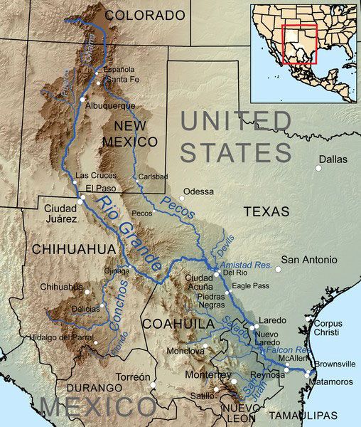
The map of the Rio Grande watershed shows the Pecos River flowing through eastern New Mexico and West Texas, where it joins the Rio Grande near Del Rio, Texas. Photo courtesy Wikipedia.
They traveled down the Rio Grande Valley from El Paso for about 100 miles, then turned eastward to the Pecos, down the right bank of the Pecos River Valley for about 60 miles, then on to the Devils River, which they followed to within a few miles of its junction at the Rio Grande. This location was not the first crossing; instead, it was the first suitable location with adequate approaches for wagons to cross the river above its confluence with the Rio Grande. The second crossing was at Bakers Crossing, 20 miles north of present-day Comstock, Texas. From April 2 to October 25, 1854, the first crossing on the Devils River was protected by Camp Blake under the command of Lieutenant Samuel H. Reynolds and members of Company K, 1st Infantry. Established shortly after the Mexican-American War, Camp Blake was named for Lieutenant J.E. Blake, a topographical engineer who distinguished himself in the Battle of Palo Alto (the first battle of the Mexican-American War, fought at Palo Alto, Texas, May 8, 1846). There were 18 more crossings of the Devils River above Bakers Crossing before reaching Horsehead Crossing — the last crossing before the San Antonio-El Paso road headed west to El Paso.
Lieutenant Smith felt that the return route was the more practical of the two, followed by the expedition, and estimated that the existing trail could be widened and made passable for Army freight trains in less than three weeks. At that time, road building consisted of clearing trees and brush, putting logs in creek bottoms and low-water crossings to prevent wagon wheels from bogging down in the mud, and cutting and grading the approaches to embankments and stream beds. In actuality, much of the proposed lower route up the Devils and Pecos River Valleys coincided with the traditional trails through this wilderness area; thus, what the U.S. Army proposed amounted to upgrading the existing trail to accommodate larger military and commercial freight-hauling wagon trains.
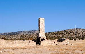
Fort Lancaster Ruins.
Lieutenant Whiting noted that security along the lower route could only be maintained by establishing a chain of forts at strategic points along the road. This recommendation led to the establishment of Fort Clark in 1852, Fort Davis in the fall of 1854, Fort Lancaster in the summer of 1854, and Camp Hudson in the summer of 1857.
Even with this line of forts, however, it was not until the 1870s, after the Civil War, that relatively safe passage was assured along this route. The expedition maps indicated that water holes were scarce and widely spaced west of the Pecos River. In 1853, Jefferson Davis, U.S. Secretary of War, appointed Captain John Pope to oversee the digging of water wells in locations where water was 40 miles or more apart. Although some wells were successful, they seldom produced water in sufficient quantities to meet the needs; consequently, the project failed. In March of 1849, the U.S. Army and a group of ordinary citizens from Austin, Texas, organized a freight train to establish direct commercial relations with El Paso. Under the joint direction of U.S. Army Major Robert S. Neighbors and Dr. John S. Ford, the group consisted mainly of Austin citizens with commercial interests, along with a few “friendly Indians.” The friendly American Indians consisted of John Harry, a Delaware Indian; Joe Ellis and Tom Coshatee, both Shawnee; Mo-po-cho-co-po and Buffalo Hump, Comanche Chiefs; and Patrick Gowin, a Choctaw. Striking westward at the North Bosque near Austin on March 23, 1849, the Neighbors-Ford Expedition reached Horsehead Crossing on the Pecos River on April 17 and arrived in El Paso on May 2. Four days later, the expedition began the return journey, traveling eastward back over the Guadalupe Mountains to Horsehead Crossing on the Pecos River, then across Concho and Brady’s Creek, and on to the San Saba and Llano Rivers, and finally southeasterly to San Antonio, arriving on June 2.
The routes taken to and from El Paso were mapped by the Neighbors-Ford Expedition, even though it was not one of the “official” expeditions involving the Bureau of Topographical Engineering. Nonetheless, it was part of the federal government’s more extensive exploration policy in Texas. It, therefore, should not be interpreted as a purely commercial venture by Austin businessmen attempting to be the first to establish regular commerce with El Paso.
The Neighbors-Ford and the Whiting-Smith Expeditions generally followed the same outbound route to El Paso. The significant difference between the two expeditions was their return routes. That of the Neighbors-Ford Expedition soon became known as the “upper road,” while the return route of the Whiting-Smith Expedition became known as the “lower road.” The lower road, from San Felipe Springs (present-day Del Rio) to Horsehead Crossing on the Pecos River, would eventually be known as the Military or Government Road connecting Fort Lancaster, Camp Hudson, the community at San Felipe Springs, Fort Clark, and Fort Inge. To others, the road was known as the Lower Immigrant Road for settlers heading to California from the Gulf ports of Texas, such as Galveston and Indianola. Portions of the route would also come to be known as the Chihuahua Road. Present-day Texas Highway 163 from Comstock to Ozona, Texas, follows sections of the original government road up the Devil’s River Valley to Horsehead Crossing.

Fort Clark Quartermaster’s Building.
To test the practicality of the Whiting-Smith Expedition’s recommendation to establish the lower road through Val Verde County (and Amistad Reservoir basin) as the principal route from San Antonio to El Paso, the U.S. Army organized a large freight train to travel the route. Under the command of Brevet Major Jefferson Van Horn, the wagon train departed San Antonio, heading west through the settlements of Castroville, Quihi, and Vandenburg, Texas, en route to crossing the Frio River near Sabinal, Texas. At the Frio River, a small train of wagons under the command of Lieutenant Colonel J.E. Johnston and Lieutenant William F. Smith set out in advance of the leading group to reconnoiter the general area and make improvements to the existing trail. The group’s central body continued west to the first crossing of the Devils River (now submerged under Lake Amistad), stopping briefly at Fort Inge on the Leona River to pick up additional men and equipment.
By this time, Van Horn’s group included six companies of the Third Infantry, 275 wagons, and 2,500 animals. From a modern perspective, it’s hard to imagine a group this size traveling together through the wilderness canyonlands of Val Verde County and the Amistad Reservoir basin. Van Horn’s group probably stretched out over a mile as the wagon train snaked its way up the sinuous Devils River valley and its 18 river crossings before reaching Horsehead Crossing on the Pecos River. Van Horn’s expedition arrived in El Paso on September 8, 1949, with no major incidents on the trail. The 650-mile trip took precisely 100 days to complete.
Van Horn’s wagon train demonstrated, beyond any doubt, that the route was viable and should be relied upon in the future as a primary transportation link for the settlement of Texas and the western United States. As the lands along the Rio Grande in New Mexico and the Arizona Territory opened to U.S. commerce and settlement, the Federal government laid the foundations for continued westward expansion.

The Mesilla Valley of New Mexico, courtesy Wikipedia.
President Franklin Pierce sought to secure the United States’ possession of the Mesilla Valley in New Mexico, near the Rio Grande. At the time, the area was considered the most practicable route for a southern transcontinental railway to the Pacific coast. The United States government, therefore, entered into negotiations with Mexico to more precisely define the border west of El Paso, which had been vaguely delineated in the 1848 Treaty of Guadalupe Hidalgo. The negotiations concluded with the Gadsden Purchase in 1853, when the United States paid $10 million for approximately 30,000 square miles of land. The area today forms the southern border of New Mexico and the Arizona border south of the Gila River Valley. The legacy of the San Antonio-El Paso Road is the opening of the American West. From the 1850s to the early 1880s, this road through the Amistad Reservoir basin was a crucial link in the West’s rate of development. Then, in 1883, everything changed abruptly with the completion of the Southern Transcontinental Railroad. The railway instantly signaled the end of the government’s reliance on wagon trains. Troops, equipment, and messages could move faster, farther, and cheaper by rail and telegraph. Within a few years, the old wagon trail that had helped open West Texas became used mainly as a thoroughfare for regional traffic. Gone were the mail riders, stagecoaches, and government wagon trains, as the steam engine and railcars replaced the mule and wagon trains.
Compiled and edited by Kathy Alexander/Legends of America, updated April 2026.
Also See:
Sources:
Historical Marker Database
National Park Service (Dead Link)
Texas State Historical Association