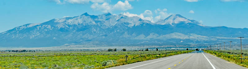
San Luis Valley south of Fort Garland, Colorado, with Blanca Peak in the background, by Kathy Alexander.
The area comprising the San Luis Valley of south-central Colorado, along with a small portion that overlaps into New Mexico, has a rich and colorful history.
With its headwaters in the San Juan Mountains, the Rio Grande runs from about seven miles east of Silverton, Colorado, through the San Luis Valley before heading south into New Mexico. Encompassing approximately 8,000 square miles, it comprises six counties and portions of three others, with an average elevation of 7,664 feet. Though it has a cold desert climate, it has substantial water resources from the Rio Grande and groundwater.

Conejos Peak, Colorado, courtesy Wikipedia.
Native American Paleo-Indian cultures, beginning with the Clovis and Folsom Cultures some 11,000 years ago, were the first known inhabitants of the area. The Archaic people inhabited the area before the Ute Indians settled in the valley, hunting animals and gathering native plants. In addition to the Ute, the Navajo, Apache, and Comanche also came to the area to trade, hunt, and raid. The nomadic lifestyle of the Ute and their visitors left little evidence of their traditional, seasonal camps. However, the extensive distribution of campsites, arrowheads, stone chips, and other artifacts across the land within the Conejos Peak Ranger District attests to centuries of living.
Trails worn deep by the passage of thousands of feet persisted through time. One of the heaviest used trails passed between the Chama River Valley in New Mexico over Cumbres Pass, along a route similar to that taken today by Highway 17. From Cumbres Pass, the trail descended along La Manga Creek to the foothills bordering the San Luis Valley.
The vast San Luis was once a northern frontier of the Spanish Empire, and the Spanish began exploring the San Luis area during the late 1500s. During the 17th and 18th centuries, occasional expeditions departed from Santa Fe to explore the valley and surrounding mountains, often in conjunction with military campaigns and trade. One of the most noteworthy expeditions was that of Governor-General Don Diego de Vargas, which passed through the area in 1694. Later, to get people to settle the area, Mexico established numerous land grants within the Spanish territory.

Juan Bautista de Anza.
Almost a century later, in the summer of 1779, Governor Bautista de Anza and his army of 600 met their Ute and Apache allies on the Conejos River to proceed north on a campaign against the Comanche. This was an attempt to crush the Comanche, who threatened the Spanish settlers. This north-south route continued to be used by Spanish, French, Anglo trappers, traders, and finally, settlers traveling between present-day New Mexico and Colorado.
In the winter of 1807, Captain Zebulon Pike and a small contingent of men were exploring the newly acquired “Louisiana Purchase” and arrived in the San Luis Valley. They built a small shelter on the Conejos River, six miles upstream from its confluence with the Rio Grande, in what was then Spanish territory.
By the 1820s, pack trains were regularly moving along the centuries-old north-south trails of the valley. The natives in the area had initially blazed these paths, taking advantage of a natural contour in the foothills; dry, open, and easy underfoot for man or beast. At the end of each day’s march, along these trails were good landmarks, grass, and cool streams, fresh from the mountains. Many of the pack trains from New Mexico were heading to California carrying wool, furs, and blankets out, bringing back California mules and horses, and sometimes, captured Paiute women and children. This was the North Branch of the Old Spanish Trail from Santa Fe to Los Angeles. Cattle and sheep still utilize these old trails today.

National Old Spanish Trail in Colorado.
The Conejos River region remained in the hands of the Spanish until the liberation of Mexico from Spain in 1821. The Mexican Republic attempted to settle the San Luis Valley by offering land grants to groups of people, promising to settle them. The Tierra Amarilla Land Grant, encompassing some 500,000 acres of present-day northern New Mexico and southern Colorado, was the second largest of the Mexican land grants. This grant was later broken into several parcels, one of which is now managed as the Banded Peak Ranch and borders the Conejos Peak Ranger District on the west. The Banded Peak Ranch manages the Gramps’ Oil Field, which has produced over five million barrels of oil since its discovery in 1935.
The Conejos Guadalupe Land Grant, which comprised portions of present-day Conejos, Rio Grande, and Saguache Counties, was bestowed in 1833 to a group of families from northern New Mexico. Despite the grants, Indian opposition to settlement slowed colonization of the valley.
The area was administered as part of the Spanish, later Mexican, province of Nuevo México until it was ceded to the United States in 1848, following the Mexican-American War, as outlined in the Treaty of Guadalupe-Hidalgo.

Ute Warriors.
The Ute Indians made a treaty of peace with the United States in 1849 after the Mexican-American War. Shortly thereafter, settlers from New Mexico established several small settlements in what is now the state of Colorado.
However, most of the region remained largely unsettled until it became part of the United States territory around 1850. Afterward, these grants began to be settled by New Mexico families. Between 1850 and 1880, a series of treaties relocated the Ute Indians from the valley to the Ute Mountain, Southern Ute, and Uintah reservations in western Colorado and Utah. They continued to play a role in Saguache, Colorado, in the northwestern corner of the valley from the Los Pinos Agency to the west until they lost their extensive reservation due to the Meeker Massacre in 1879.
Afterward, extensive settlement began in the San Luis Valley, primarily by Hispanic farmers and ranchers from New Mexico. The first permanent settlement in Colorado, known as San Luis de la Culebra, was established in 1851 on the Rio Culebra River on the Sangre de Cristo Grant. A year later, Fort Massachusetts was established north of San Luis to protect the early settlers in the valley. Early settlers built a church in the village of San Luis and dedicated it on the Feast of Saint Louis, June 21, 1851.

Fort Massachusetts, Colorado.
From 1852. The U.S. Cavalry of Fort Massachusetts patrolled the area roads and the open county to keep the peace or to campaign in war against the Ute, who had become angry and desperate at losing their lands. In 1858, Fort Garland, built at the base of Mount Blanca, succeeded Fort Massachusetts.
La Loma de San Jose, near the present Del Norte, was first inhabited by Hispanic families from the Santa Fe area in 1859. Irrigation ditches were constructed and farms established.
Settlement of farms and ranches increased in the southern valley, where the early Hispanic settlements were centered in the 1860s. Much of this was due to the homestead system and large-scale irrigation canal projects. As ranching activities, such as building houses, barns, corrals, fences, and cutting fuelwood, increased, the demand for forest products grew, leading to commercial timber activities.
Formerly part of New Mexico, the San Luis Valley became part of the Territory of Colorado in 1861.

Felipe Espinosa.
In the early 1860s, the outlaw Felipe Espinosa and his vicious Bloody Espinosas gang, who terrorized Colorado, operated out of the San Luis Valley.
Gold and silver were discovered near Summitville in 1870, marking the beginning of the mining rush to the area. Other mining settlements followed at Bonanza, Creede, and along the Sangre de Cristo Mountains. Del Norte, one of Colorado’s earliest cities, established in 1872, served as a supply point and gateway to the San Juan mining camps. The mining boom brought attention to the upper reaches of the Conejos River, within the eastern San Juan Mountains. On the edge of the prosperous Summitville, a mining district sprang up, Platoro, on the upper Conejos River. Silver and some gold were extracted from the Platoro mines, but the high expense of transportation from this remote region led to the decline of the mining community.
The establishment of agricultural communities by people from New Mexico continued slowly. The valley population soared in the late 1870s and early 1880s when Mormon settlers from the southern U.S. and Utah established the towns of Manassa, Sanford, and Richfield. Manassa and Sanford became prosperous agricultural communities, using the irrigation waters of the Conejos River to grow barley, oats, alfalfa, and peas.

Summitville, Colorado Mining District, 1870s.
In the 1880s, the Denver and Rio Grande Railway constructed its San Juan Extension between Alamosa and Durango to tap the booming mining industry of the San Juan Mountains. The railroad survived the decline of the mining industry by transporting lumber, passengers, livestock, freight, mail, and oil.
In 1891, an Act of Congress authorized the establishment of Timber Reserves to conserve the nation’s timber, range, and water resources. Portions of these established reserves were combined to form the Rio Grande National Forest in 1908.
By 1917, the Denver and Rio Grande Railway operated nearly 6,000 miles of track, primarily in Colorado and Utah. Over the years, the railroad built some of the most challenging tracks in existence, including the highest mainline railroad in the United States (over 10,000 feet) at Tennessee Pass in Colorado and the famed routes through the Moffat Tunnel and the Royal Gorge. Although the railroad utilized the latest standard-gauge technology to compete with other transcontinental carriers, it also continued to operate the surviving steam-powered narrow-gauge lines, including the renowned Durango and Silverton Narrow Gauge Railroad, which ran between Durango and Silverton, Colorado. However, most of the remaining narrow-gauge trackage was abandoned in the 1950s and 1960s.

Denver and Rio Grande Railway in Eagle River Canyon, Detroit Photographic Company.
When the Denver and Rio Grande decided to abandon the route, active citizen interest convinced the States of Colorado and New Mexico to purchase the 64 miles of track between Antonito, Colorado, and Chama, New Mexico. The Cumbres and Toltec Scenic Railroad and the Durango-Silverton line are the last remnants of the once extensive narrow-gauge steam railway. It is listed on the National Register of Historic Sites and protected under the National Historic Preservation Act of 1966.
The last Denver and Rio Grande narrow-gauge line, from Durango to Silverton, was sold in 1981 to the Durango and Silverton Narrow Gauge Railroad, precisely 100 years after the line went into operation.
Today, Agriculture and stock-raising of both sheep and cattle remain the central base of the economy. The valley has a diverse Anglo and Hispanic population. Many of the Hispanics are directly descended from the original New Mexican settlers.
This spiritual and intriguing valley provides epic 100-mile views, dunes surrounded by soaring peaks, and a long history of Native American, Hispanic, and European settlers and explorers.

Elk at the Great Sand Dunes of Colorado.
Much of the beautiful landscape remains largely unchanged, allowing visitors to enjoy activities such as mountain biking, scenic hikes, skiing, fishing, camping, and more along the Rio Grande, the stunning Sangre de Cristo Mountains, and Great Sand Dunes National Park & Preserve.
Blanca Peak, a standing sentinel above Fort Garland, is the fourth-highest summit of the Rocky Mountains at 14,351 feet. Since time immemorial, Mount Blanca has been the sacred Mountain of the East to the Navajo people of the Four-Corners country of Arizona, Utah, New Mexico, and Colorado. It lies approximately 20 miles east-northeast of Alamosa, and 15 miles to the north-northwest is Great Sand Dunes National Park and Preserve.
©Kathy Alexander, Legends of America, updated October 2025.

A Cumbres & Toltec Scenic Railroad steam train pulls into the tiny Osier, Colorado, by Carol Highsmith.
Also See:
Bloody Espinosas – Terrorizing Colorado
Colorado – The Centennial State
Denver & Rio Grande Western Railroad
Fort Garland, Colorado – Frontier Outpost of the Plains
Sources: