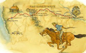
Division Three of the Pony Express Trail consisted of 46 stations. This division was the second-largest division of the Central Overland California & Pike’s Peak Express Company’s Pony Express. Only Division Five surpassed Division Three in the number of stations. Division Three went from Horseshoe Creek, Wyoming, across the vast stretches of Wyoming’s high desert landscape to South Pass, through the Rocky Mountains, southwest to the Wyoming Basin and Green River, and then through the Wasatch Range to Salt Lake City, Utah.
Wyoming:
Elk Horn Station – Several historians list Elk Horn as the first station west of Horseshoe Creek. It was located ten miles from Horseshoe Pony Express Station and 15 miles from La Bonte Station. The old Emigrant Road crosses Elkhorn Creek just north of the station site.
LaBonte/LaBonte Station – The next station after Elk Horn was probably La Bonte Station, which several sources agree was a Pony Express station. In August 1860, the route apparently changed to include La Bonte as a station for an unknown reason. Little existed at the site before that, except for a stock corral. Stagecoaches also stopped at LaBonte but used a separate site from the Pony Express station. It is located 15 miles from Elk Horn Station and 10 miles from Bed Tick Station.
Bed Tick Station – The 1861 Overland Mail Company contract listed Bed Tick as a passenger/mail station stop. It was located 10 miles from LaBonta Station and 8 miles from Lapierelle Station on the south side of Bedtick Creek.
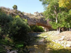
La Prele Creek, Wyoming, courtesy Wyoming History
Lapierelle/La Prele Station – The 1861 Overland Mail Company contract listed Lapierelle as a passenger/mail station stop. It was located 8 miles from Bed Tick Station and 10 miles from Box Elder Station on the south side of La Prele Creek and just north of the old Emigrant Road. About four miles west of LaPrele Station, in July 1864, more than 200 Oglala Sioux attacked the Kelly-Larimer Wagon Train.
Box Elder (Creek) Station – Little is known about the history of Box Elder Creek Station other than several sources agree that it served as a Pony Express station. A man named Wheeler managed the operations at Box Elder, which also served as a passenger/mail stage stop under the 1861 Overland Mail Company contract. It was located 10 miles from Lapierelle Station and 10 miles from Deer Creek Station south of Box Elder Creek.
Deer Creek Station – Several sources agree on the identity of Deer Creek as a station for the Pony Express, largely because it appeared on the 1861 Overland Mail Company contract. The site existed before the Pony Express as an Indian trading post during the 1850s. The site first took the name of “Deer Creek Station” as a relay terminal for the Overland Stage system. In 1860, it became a “home station” for the Pony Express. It gained a telegraph station in 1861. Stagecoaches and other travelers also stopped here on the route of the Oregon Trail. Structures at Deer Creek included Indian Agent Major Twiss’ headquarters, a post office, a store, and a saloon. The property was owned by an Indian Trader named Bisonette, who was the Station Keeper for a while.
A remarkable feat of courage by pony rider Henry Avis took place here, resulting in the Pony Express Company paying him a bonus of $300 for exceptional bravery. Upon reaching Horseshoe Station, Avis found the relay rider unwilling to carry the mail. Up ahead, marauding Sioux Indians were on the warpath, making the trail a veritable death trap. Undaunted, Avis changed horses and rode into the night. He reached Deer Creek only to find the station abandoned, the station keeper missing, and all the relay mounts stolen. To compound matters, the eastbound pony rider arrived, refusing to ride further. So, once more Avis took the saddle, returning to Horseshoe Station, without a rest he had covered 220 dangerous and bone-weary miles.
Indians finally burned Deer Creek Station on August 18, 1866. Today, the site is located within the city of Glenrock, Wyoming. An interpretative sign is on the southwest corner of Fourth and Cedar Streets, in front of the schoolyard.
Little Muddy Station – Located near Little Muddy Creek, the stone station, erected without mortar, reportedly stood ten miles west of Deer Creek. However, its exact location has not been identified.
Bridger Station – Named after frontiersman Jim Bridger, the Overland Mail Company contract of 1861 identifies this station as located between Deer Creek and North Platte/Fort Casper. It was located 10 miles from Deer Creek Station and 15 miles from North Platte Station, west of Muddy Creek and north of the Old Emigrant Trail. The Bridger Station Post Office was established in Carter County on July 15, 1869. Edward D. Titus as the postmaster. The post office was on October 10, 1871.
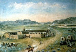
Platte Bridge/Fort Casper/North Platte Station – Several historical sources name North Platte or Fort Casper as the location of this station, mainly because this name appears on the 1861 Overland Mail Company contract. Other sources mention Platte Bridge Station, on the North Platte River, as the site of this station. In any event, most historians list the site as the predecessor of Fort Caspar. The site was first established in 1859-60 when Louis Guinard built the Platte Bridge for $40,000. He soon added a trading post. The toll for wagons for emigrants to cross the river ranged from $1 to $6, determined by the river’s height. An additional toll was charged for animals and people.
Guinard’s post became an Overland Stage Company stage stop from 1859-1862, a Pony Express relay station in 1860-1861, and home to a telegraph line in October 1861, when the Pacific Telegraph Company added an office to the site. Fort Caspar was established in 1865 and the bridge was used until Fort Caspar was abandoned in 1867.
Red Buttes Station – Located on a ridge overlooking the North Platte River at Bessemer Bend, explorers, fur traders, mountain men, and emigrants were known to have camped at this site before a Pony Express station was established here. William “Buffalo Bill” Cody, one of the youngest Pony Express riders at the age of 15, made the longest non-stop ride from this station. Completing his run of 116 miles between Red Buttes and Three Crossings, he found his relief rider had met an untimely death, causing Cody to ride an extra 76 miles to Rocky Ridge Station. He immediately returned from Rocky Ridge to Red Buttes, completing the route in record time. The station was located about ten miles southwest of present-day Casper, Wyoming.
Willow Springs Station – Located near Willow Creek and Spring, this site served as a home station for the stage lines and a relay station for Pony Express riders. The stop once consisted of a crude structure without a corral. In 1862, the stage line route via Fort Laramie and the Great South Pass was abandoned for a more southern trail through Bridger’s Pass. Thus, within several years, the building at Willow Springs became obsolete and began to collapse from decay. It was situated 2 miles from Red Buttes Station and 14 miles from Horse Creek Station.
Horse/Greesewood Creek Station -Several sources list Horse Creek as a station, including the 1861 Overland Mail Company contract. It was located 14 miles from Willow Springs Station and 12 miles from the Sweetwater Pony Express Station on the east bank of Horse Creek, just north of the old Emigrant Road.
Sweetwater Station – Sweetwater existed as a Pony Express station until the summer of 1860 when officials abandoned the site in favor of Split Rock. Nevertheless, it still appeared on the 1861 Overland Mail Company contract for some unknown reason. It was located 12 miles from Horse Creek Station and six miles from Devil’s Gate Station on the north bank of the Sweetwater River. Independence Rock is about one mile west.
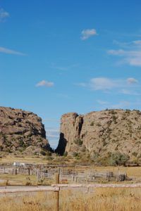
Devil’s Gate Station – Though not mentioned in the 1861 Overland Mail Contract, historians generally agree that this was the site of a Pony Express Station. The Pony Express Route and the Oregon Trail are the same through this part of Wyoming. Devil’s Gate, a 370-foot high, 1500-foot-long cleft carved over the centuries by the Sweetwater River, was a significant landmark on the Oregon Trail. It provided a pleasant change for weary travelers coming across the rough, dry country from the North Platte River, a four-day trek from the east. It was located six miles from Sweetwater Pony Express Station and six miles from Plant’s Station.
Plant’s/Plante Station – The 1861 Overland Mail Company contract specifically identifies Plant(e) ‘s station as a Pony Express stop. The station tender’s last name was Plant(e). It was located 12 miles from Sweetwater Pony Express Station, six miles from Devil’s Gate Station, and 12 miles from Split Rock Station, about 400 feet south of the Sweetwater River.
Split Rock Station – In this vicinity, Russell, Majors & Waddell erected a stage station in 1859. This station appears on the 1861 Overland Mail Company contract. A French-Canadian named Plante managed operations at the station. The site consisted of a crude log structure with a pole corral and was located on the south side of the Sweetwater River. Buffalo Bill’ Cody exchanged horses at Split Rock Station on a record ride from Red Buttes Station to Rocky Ridge Station and back. Due to another rider’s untimely death, Cody was forced to do an extra leg to his normal relay and eventually covered a total distance of 322 miles in 21 hours and 40 minutes, using 21 horses in the process. The site was located 12 miles from Plant’s Station and 14 miles from Three Crossings Station.
Three Crossings Station – Located on the Sweetwater River, it took its name from the fact that the trail crossed the stream three times within a quarter of a mile. A home station for both the stage lines and Pony Express riders, the site appeared on the 1861 Overland Mail Company contract. A Mormon couple with the last name of Moore managed station operations. It would also feature a telegraph station. It was to this station in 1860 that 15-year-old Pony Express carrier Bill Cody rode from Red Buttes on the Platte River, 76 miles away. There, he found that the rider of the 85-mile stretch to Rocky Ridge had been killed. Without resting, he then rode to Rocky Ridge and returned to Red Buttes with the eastbound mail on time. This 322-mile ride is the longest on the records of the Pony Express. It was located 14 miles from Split Rock Station and 12 miles from Ice Springs Station.
Ice Slough/Ice Springs Station – This site was listed in the 1861 Overland Mail contract as a Central Overland California & Pike’s Peak Express Company station. It was well known for nearly year-round ice in a grassy swamp. It was 12 miles from Three Crossings Station and 12 miles from Warm Springs Station, just north of the Old Emigrant Road.
“Here, we found a great curiosity. [It] would seem that vegetation & frost had agreed to operate in copartnership, for digging through a grassy turf to open a Spring, we found plenty of Ice!”
— Norton Jacob, Mormon pioneer, June 24, 1847
Warm Springs Station – Located on the Seminoe Cutoff from the Oregon Trail, this station was 12 miles from Ice Springs Station and 12 miles from Rocky Ridge Station/St. Mary’s Station.
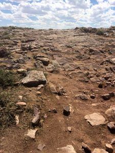
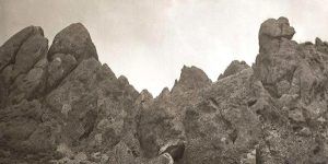
Rocky Ridge, Wyoming, courtesy of Wyoming History
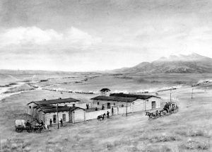
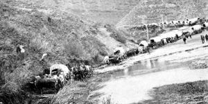
Rocky Ridge/St. Mary’s Stage Station – The 1861 Overland Mail Company contract listed this station site as Rocky Ridge, but apparently, the station was also known as St. Mary’s. A home station, it was built in 1859 by Russell, Majors, and Waddell on the east side of Silver Creek. When the transcontinental telegraph line was established in 1861, it was made a depot. Willaim Reid was the station tender. Also situated on the Oregon Trail, this rugged stretch of trail caused the emigrants no limits of grief as they ascended this barren rocky ridge after leaving the Sweetwater Valley en route to South Pass.
Rocky Ridge was said to have been the scene of a record-setting Pony Express ride in 1860 when Buffalo Bill Cody rode the 76-mile stretch from Red Buttes to Three Crossings. One day, when he reached the Three Crossings Station, he learned that the next rider had been killed in a drunken altercation the previous night. Cody agreed to ride the next 85 miles to Rocky Ridge. The trip from Red Buttes and return was 322 miles in 21 hours, the third longest ride on record.
On the eastern edge of Rocky Ridge sits a monument to the misery endured at this site by Morman Trail by Willie’s Handcart Company. The station was located 12 miles from Warm Springs Station and 12 miles from Rock Creek Station.
“Rocks in the trail on Rocky Ridge “lay in rows and lapping one upon another like shingles on the roof of a house.” — Grenberry Miller, June, 1849
Rock Creek Station – The 1861 Overland Mail Company contract included this station, which was situated near the old Lewiston townsite. Some sources also call this site Strawberry Station because of its proximity to Strawberry Creek. The Station Tender was a man with the last name of McAchran. It was located 12 miles from Rocky Ridge Station Station and 12 miles from Upper Sweetwater Station.
Upper Sweetwater/South Pass Station – South Pass was perhaps the most significant transportation gateway through the Rocky Mountains as Indians, mountain men, overland trail emigrants, Pony Express riders, and miners recognized the value of this pass straddling the Continental Divide.
Located on the emigrant trail, this was originally the site of Gilbert’s Trading Post, which also included a blacksmith shop. It was built by Henry S. Gilbert and a man named Garrish on the north bank of the Sweetwater River. In the spring of 1858, John M. Hockaday & Company assumed the Missouri to Salt Lake City mail services, and Gilbert’s Trading Post became a stagecoach stop. When the main line was sold to Central Overland California & Pike’s Peak Express Company, Gilbert became the station tender, a position he retained when the station also became a Pony Express Stop. It was here that the Seminoe Cutoff rejoined the original Oregon-California Trail and where the Lander Road branched off.
Because the station became a favorite target for Indian attacks, a unit of the 11th Ohio Volunteers was garrisoned at the site in 1862. When the military abandoned the station in 1868, the Indians burned it to the ground.
Over the years, the site was variously known as Gilbert’s Station, Upper Sweetwater Station, Ninth Crossing of the Sweetwater, Ford Number 9, South Pass Station, and finally, Burnt Ranch.
The station was located 12 miles from Rock Creek Station and 12 miles from Pacific Springs Station.
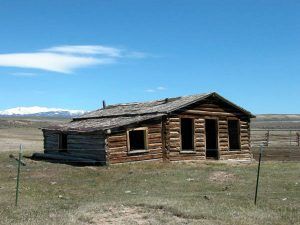
Pacific Springs Station, Wyoming, courtesy of Wonders of Wyoming.
Pacific Springs Station – Located approximately two miles west of the Continental Divide, this area was first discovered by the Sublette brothers in 1820. It was during the great migration of the California-Oregon Trails in the 1840s that it gained its name. It marked the halfway point of the long journey from Missouri to the Oregon Territory. The town of Pacific Springs was founded in 1853. A few years later, Pacific Springs would serve as a relay station for both the stage lines and the Pony Express. The station tender was a Mr. Botswain. It was located 12 miles from the Upper Sweetwater Station and 12 miles from Dry Sandy Station.
Pacific Springs is located in present-day Fremont County, just a few miles west of South Pass, where eight structures from the old town still remain.
Read More: Pacific Springs | Wonders of Wyoming
Dry Sandy Station – Situated on the west bank of Dry Sandy Creek and just south of the old Emigrant Road, a young Mormon couple managed station operations at Dry Sandy Station. It was located 12 miles from Pacific Springs Station and 15 miles from Little Sandy Station.
Little Sandy Creek Station – This relay station was located near the junction of the Great Salt Lake Road and on the road to Fort Hall, Idaho. It was located 15 miles from Dry Sandy Station and 13 miles from Big Sandy Station on an elevation west of Little Sandy Creek.
Big Sandy Station – A relay station for the Pony Express and stagecoach stop for the Overland Mail, a Mormon couple ran it. It was burned by Indians in 1862. It was located 13 miles from Little Sandy Station and 15 miles from Big Timber Station. There are two historical markers just past the intersection of Highways 28 and 191 in Farson, Wyoming. A few yards south of these markers, a modern bridge crosses the Big Sandy Creek.
Big Timber Station – The U.S. mail contract of 1861 lists Big Timber as a station, probably situated on the north bank of Big Sandy Creek. It was 15 miles from Big Sandy Station and 15 miles from Green River Station.
Green River (Crossing) Station – Green River served as a home station for both the stage lines and pony riders, and it was situated near an early fording area of the river. The station manager was a Mr. McCarthy. It is 15 miles from Big Timber Station and 20 miles from Ham’s Fork Station.
Michael Martin’s Station – Located approximately ten miles southwest of Green River Station, the station was managed by a French-Canadian man named Michael Martin. Martin also managed a trading post, where he sold various items. It is known that the site was a stagecoach stop in 1860, making it highly likely that the Pony Express stopped there, too. However, the 1861 U. S. mail contract did not identify it as a station, indicating it may have been eliminated as a station by March 1861. The station was located between the Green River Station and Ham’s Fork Station
Ham’s Fork Station – Historical sources agree on the identity of Ham’s Fork as a station, including the 1861 mail contract. David Lewis, a Scottish Mormon, managed station operations with his two wives and a large family.
Fur trappers and traders passed the confluence of the Ham’s and Black’s forks of the Green River as early as 1824, frequented the area often, and the fur trade’s annual rendezvous at the spot in 1834. By the 1840s, emigrants along the California-Oregon Trail crossed Ham’s Fork near its mouth. In about 1850, the station consisted of a dugout affair. In 1856, a stone stage station was built at the site, later serving as a stop on the short-lived Pony Express route. When the Overland Stage changed from its South Pass route in 1862 to use the Bridger’s Pass and Bitter Creek route instead across southern Wyoming, the station was renamed South Bend Station.
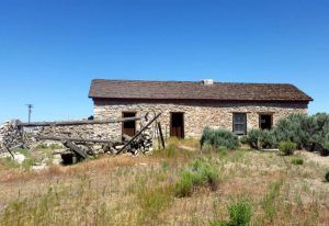
The name was changed to Granger when the Union Pacific Railroad was built through the area in 1868. The station still stands today at 110 Spruce Street in Granger, Wyoming. The station building, with two-foot-thick walls of cut native stone and lime-sand mortar, represents the different eras of transcontinental travel.
Church Butte Station – Church Butte was an important landmark across southwestern Wyoming on the Oregon/California/Mormon Trail. Near here stood a relay station for the Pony Express. The butte lies about 13 miles northwest of Lyman, Wyoming, and 10 miles southwest of Granger, Wyoming.
Millersville Station – This area was first utilized by whites as early as 1834 when “Uncle Jack” Robinson, a trapper, trader, and friend of James Bridger, first built a dwelling here. Later, it became a trading post. When the site became a stage station, it received its name from A. B. Miller, a partner of William Russell and William Waddell. A Mormon named Holmes managed the station and ran a trading post. It was located 20 miles from Ham’s Fork Station and 12 miles from Fort Bridger, reportedly near where the old Emigrant Road crossed Smith’s Fork.
Fort Bridger – Historians debate whether there was a Pony Express station located at the fort. Some say that there was insufficient grazing land on the government’s property and that riders probably only stopped briefly to get the mail at Judge W. A. Carter’s store and post office before heading to Muddy Creek Station. Others say that a station existed in the fort’s quartermaster building. What is known for sure is that in 1857, General A. S. Johnston’s Army of Utah established winter quarters at the fort and maintained a supply contract with the freighting firm of Russell, Majors, and Waddell, who also operated the Pony Express. Thomas O. King, who was a rider here, is credited with making a long ride from Salt Lake to Hams Fork, a distance of 149 miles.
Fort Bridger was established in 1842 by mountain man James Bridger and Louis Vasquez. It served as a trading post for those who were traveling westward along the emigrant rails. In the beginning, the fort was not very nice and was a disappointment to many of the travelers. It was simply two log cabins about 40 feet long connected by a fence to hold horses. The visitors also complained about insufficient supplies and overpricing. In 1868, Fort Bridger became a military outpost.
Strategically located on the Black’s Fork River, the fort was second only to Fort Laramie, Wyoming, as the most important outfitting point for the emigrants along the overland trails. Today, Fort Bridger is a historic site where Jim Bridger’s trading post has been reconstructed, and some of the original military buildings still stand.
Muddy (Creek) Station – Several sources identify Muddy or Muddy Creek as a home station, including the 1861 mail contract. A French-Canadian and his English wife served as station keepers. It was located 12 miles from Fort Bridger and 11 miles from Quaking Aspen Station on the north side of Muddy Creek.
Quaking Asp/Aspen/Springs Station – This station was in the 1861 Overland Mail Company contract. it was located 11 miles from Muddy Station and 12 miles from Bear River Station. A Quaking Aspen grove and spring are south of the station site.
Bear River Station – Though the U.S. mail contract and several other sources identify Bear River as the next station, the exact location of this site is currently unknown. A Mormon named Myers managed the station operations there. Bear River Station was the last Pony Express station in Wyoming. It was located about 12 miles from Quaking Aspen Station on the Bear River.
Utah:
The Needles/Needle Rock(s) Station – Little is known about this station besides its identification as Needle Rock in the 1861 mail contract. It was named for a very prominent rock formation near the Utah-Wyoming border. An 1869 survey showed the station’s location at Porter’s Ranch along the Omaha to Salt Lake Valley Road. The route through this area was also used by the Donner-Reed party in 1846, the Mormon Pioneers in 1847, General Johnston’s Army in 1858, and the transcontinental telegraph in 1861.
Just on the Utah side of the border with Wyoming, the site is on Yellow Creek, almost 10 miles south of the town of Evanston and approximately eight miles from Bear River Station, Wyoming. The site is on private land.
Head of Echo Canyon Station/Castle Rock – This station is mentioned in the 1861 mail contract as Castle Rock and/or Frenchies. Castle Rock refers to a sandstone geological formation near the head of the canyon. Apparently, a man named Frenchie served as the station keeper at a log structure. Though the Pony Express ended when the telegraph lines were established, the site remained a stage station until 1867. At that time, a French trapper purchased the log building and moved it about a mile away.
Attracted by the hope of trading with travelers through the canyon, a number of families homesteaded the land and began a town called Castle Rock. The active, though small community soon boasted a railroad depot, section house for railroad workers, store, water windmill, and schoolhouse.
Nothing remains of this site today. It was located about eight miles from Needle Rock Station.
The trail through Echo Canyon was one of the most important of westward expansion. Buffalo, Indians, and explorers first used this natural pathway, later followed by wagon trains, Mormon pioneers in 1847, the Overland Stage, the Pony Express, gold prospectors and silver miners, the first transcontinental telegraph line, the Union Pacific Railroad, the Lincoln Highway.
Halfway Station – A man named Daniels served as station keeper at Halfway Station, which was listed as the third Utah station in the 1861 mail contract. Local people also knew the station as Daniels and Emory. In the early days of the Pony Express, rustlers were known to steal the express horses and then later sell them back to the company. When the horses began to be branded with the XP (Express) brand, the rustling ended. Nothing remains of the site today. It was located approximately seven miles from the Head of Echo Canyon Station, about halfway down Echo Canyon.
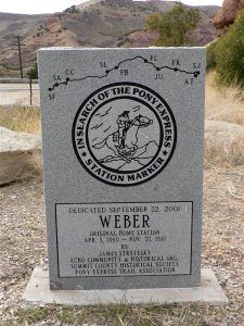
Weber Station – As early as 1853, a stone stage and pony station were built here at the mouth of Echo Canyon. James Bromley settled here in 1854. He was later hired by Russell, Majors, and Waddell as division superintendent for the section of the line between Pacific Springs, Wyoming and Salt Lake City, Utah. His ranch became the location for the Pony Express and Stage station. Bromley also managed the station operations at Weber Station. In addition to the stone station house and outbuildings, the site housed a general store, inn, saloon, blacksmith shop, jail, and, later, a hotel.
In 1868, the Union Pacific Railroad bought the station and surrounding property to establish Echo City. Apparently, the station house stood until 1931, when workers demolished it for safety reasons. Echo City still exists today, though it is almost a ghost town, with just about 50 people living there. Over the years, the location was known by various names, including Bromley’s, Pulpit Rock, Hanging Rock, and Echo City.
Brimville Emergency Station – After leaving Weber Station, under normal traveling conditions, Pony Express riders crossed Forney’s Bridge over the Weber River and rode through Bachelors Canyon to Dixie Hollow. However, when high water and snow made the normal route unsafe, riders followed the valley to the Brimville Emergency Station, also known as Henneforville (Henefer, Utah). From Brimville, riders reached Dixie Hollow by way of Little East Canyon. This station in Dixie Hollow was also commonly known as Dixie Creek, East Canyon, and Snyder’s Mill. The exact location has been a matter of considerable debate.
East Canyon Station – Identified in the 1861 mail contract, local people also knew East Canyon Station as Dixie Hollow, Dixie Creek, Bauchmanns, and Snyder’s Mill. Mr. Bauchmann and James McDonald managed station operations at the stone structure. Travelers and sheepherders used the station site as late as 1881. Today, the East Canyon Reservoir covers the historic site.
Mountain Dell/Dale Station – The 1861 mail contract referred to this station as Mountain Dale, but it was also known as Mountain Dell, Big Canyon, and Hanks Station. Ephraim Hanks served as station keeper at the log structure. Station keeper Ephraim Hanks was a colorful character on the Mormon frontier. It was widely rumored that he was a leading figure among a group of Mormon “hit-men” called the Danites, or Destroying Angels. Historians much debate the exact location of this station.
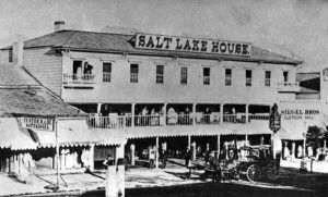
Salt Lake City Station – The last station in Division Three of the Pony Express, this home station was listed in the 1861 mail contract as Salt Lake House. The wood frame structure, kept by A. B. Miller, stood on the east side of Main Street, between First and Second South, in present-day Salt Lake City. The Salt Lake House was a home station for both stage lines and Pony Express riders. It was a long, two-story structure with a veranda in front and a large livestock yard in the rear. A granite monument with bronze plaques marks the location today.
Compiled and edited by Kathy Alexander/Legends of America, updated January 2024.
Also See:
Central Overland California & Pike’s Peak Express Company
Pony Express Stations Across the American West
Sources:
Expedition Utah
Fort Caspar, Wyoming
Genrock, Utah Chamber of Commerce
Pony Express Historic Research Study
Summit County, Utah
Wyoming State Parks and Cultural Resources
Wyoming History

