
Old stone walls have long been found throughout the New England States. In fact, in the 1930s, someone estimated that New England had 250,000 miles of stone walls. However, that number has since been doubled.
In the decades that followed, people began to wonder about the region’s hundreds of stone chambers. These distinctive stone structures, also called huts, caves, beehives, dolmens, and root cellars, have long provoked questions about their age and cultural origins.

America’s Stonehenge, Salem, New Hampshire by Alyson Horrocks, courtesy New England.com
America’s Stonehenge, Salem, New Hampshire
Calendar II, South Woodstock, Vermont
Gungywamp, Groton, Connecticut

Great Wall of Sandwich, New Hampshire, by Carol Highsmith.
Approximately 800 stone–built chambers are scattered across the New England States, with a design and form found nowhere else in North America. Generally, they are circular or rectangular, ranging from 15- 30 feet long, about 10 feet wide, and featuring a ten-foot-tall central chamber. The most elaborate structures, called “beehive” chambers, were built in a conical shape and sometimes feature smoke holes for ventilation, as well as shelves and benches incorporated into the walls. Most of the best-preserved chambers are driven into hillsides, though others are freestanding. Characteristically, they are expertly constructed with fitted masonry stone and capped with megalithic slabs. Cairns, standing stones, enclosures, ceremonial walls, pedestal boulders, and balanced rocks often surround these chambers.

Stone chamber on Rattlesnake Gutter Road, Levett, Massachusetts, courtesy of Wikipedia
Although the structures share several common features, their construction details vary widely. But they differ from other colonial structures, including stone burial vaults, charcoal and lime kilns, potash burners, and iron furnaces.
These chambers have been found in New York, Massachusetts, New Hampshire, Pennsylvania, New Jersey, Rhode Island, Vermont, Maine, Ohio, Virginia, West Virginia, and Kentucky.
Though many historians and archaeologists believe early colonists built these structures as root cellars, or that Native Americans built them before them, others believe some chambers are ancient, built by European travelers during the Bronze Age.
Intense public interest began after Professor Barry Fell, a retired marine biologist from Harvard University, examined several areas in Vermont in the 1970s. Fell said he identified inscriptions in an early form of Ogam script dating from 1000 B.C. to 300 B.C., carved in stone by “Celts from the Iberian Peninsula,” located in the southwest corner of Europe in what is now Spain and Portugal.

Celtic Druid.
The professor believed the Celts built these many megalithic chambers, which welcomed Phoenician mariners from the Mediterranean Sea. He also asserted that these structures, built along rivers in secluded valleys and on hilltops, were erected by priests (or Druids) as temples. Fell and others who support the idea of ancient European settlement also cite evidence such as stone circles, carved deities and animal figures, symbolic markings, Celtic place names, cairns, and chamber features that align with sunsets and sunrises during solar solstices and equinoxes. Further, the beehive-shaped stone chambers look very much like ancient chambers built by monks in Ireland.
However, Fell, who used his tenure at Harvard to pursue his alternative-history hobby, is not well respected by archaeologists, which immediately sparked controversy. The debate centers on two theories: historic origin and ancient origin.
Most believe early colonists built the structures as root cellars, settlers’ quarters, smokehouses, shepherds’ shelters, animal pens, whiskey storage facilities, and hunting or trapping enclosures. However, this does not explain that early records of New England colonists mention stone chambers that predate settlement and describe strange “Indian forts.” Nor does it explain that sometimes the age of the chamber could be authenticated by trees that predated settlement, and that passageways were often too low and narrow to wheel a cart into. The chambers have soil floors that would rot vegetables.

Nashoba Brook Stone Chamber, Acton, Massachusetts by John Phelan, Wikipedia.
Further, why would practical-minded colonial farmers create such complex, well-crafted megalithic “root cellars” for the simple storage of fruits and vegetables? Especially ones like these? While their homes and other buildings have long since vanished, these stone chambers still exist. Other researchers have argued that the chambers were far too large for food storage, and that most colonists built root cellars under or near their homes instead of in the upland areas where most of them are found. Why would these people have spent so much time and effort quarrying tremendous amounts of stone and hauling it to these sites when trees were abundant?
Though some have suggested Native Americans built them, this has long been generally discounted, as there is no archeological or ethnological evidence that prehistoric or historically known Indian groups undertook the level of stone construction represented by the stone chambers. Further, Native Americans in the area were known to limit their use of upland areas, where the vast majority of the chambers are located, to hunting and other short-term activities, and to live more permanently in river or lakeside environments. Additionally, nowhere in America were Native Americans known to have built stone sweat lodges.
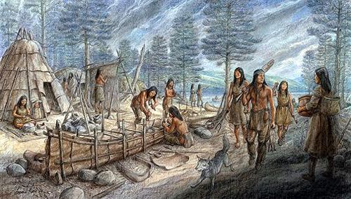
Abenaki Village.
However, many researchers today adamantly disagree and believe that American Indians, or their ancient ancestors who lived in New England before the arrival of the first Europeans, built the stone chambers. Indigenous groups from other parts of America, such as the Adena and Mississippian cultures, created entire cities and ceremonial centers with stone and dirt, so why not the structures in New England?
In the summer of 1974, Byron Dix discovered in Vermont the first of many areas in New England that he believed to be ancient Native American ritual sites. Later, he and James Mavor led a seven-year investigation into stone sites in New England. For 15 years, they worked together to research and interpret New England’s stone structures before publishing their findings in Manitou in 1889. Though neither author was a trained archaeologist, they showed that Indians had more astronomical knowledge than previously acknowledged and that New England contains a wealth of archaeological remains that archaeologists had ignored.

Manitou Book by James Mavor and Byron Dix
Manitou is the Algonquin word for God and is “the spiritual quality possessed by every part or aspect of nature, animate or inanimate… aspects of the natural world that are sensed but not understood.” This description aligns with how the early inhabitants of this continent regarded their surroundings.
The two told the story of discovering and exploring these many stone structures and standing stones. Their placement in the surrounding landscape suggests that they played an important role in celestial observation and shamanic ritual. Many of these ritual sites connect with other sites to form networks that stretch for hundreds of miles. The book’s general conclusion is that shamanism, vision-seeking, and careful solar and stellar observations were among the central motifs in the cultural beliefs of the natives who built them. The two also concluded that many of these sites were at least several thousand years old.
The authors, Mavor and Dix, were naval architects and optical-mechanical engineers, respectively. Dix is also an archaeoastronomy expert.
Others support this theory, including the Nolumbeka Project based in Greenfield, Massachusetts. This group, made up of volunteers active for more than 40 years in preservation and historical research, aims to promote a deeper, more accurate depiction of New England’s Native American history and protect sacred sites.
Nolumbeka is an Abenaki word that means “a stretch of quiet water between the two rapids.” This word likely gave rise to the name Norumbega, which early European explorers used and which appeared on maps of present-day New England from 1529 to the 1580s.

John Elliot Preaching to the Indians
Many previous researchers have given no credit to the pre-colonial age or Indian interests and abilities. New England colonists, in general, were too busy farming or trying to convert and/or eliminate the Indians to learn about the natives’ knowledge of astronomy. Further, this cultural ignorance was perpetrated by English land speculators and by some Christian ministers whose goal, as Reverend John Eliot worded it, was to “convince, bridle, restrain and civilize” the Indians “and also to humble them.”
The Algonquian-speaking tribes, along with many other peoples throughout North America, viewed the universe as divided vertically into three major realms. These included the Upperworld, which consisted of the sky; the earth itself, called the Middleworld; and everything below ground, called the Underworld. Caves and underground chambers allowed them to enter the Underworld, which was filled with powerful spirits. Many tribes have origin stories and legends strongly connected to the Underworld.
Meanwhile, the mystery remains, and speculation continues about the stone structures.
The heaviest concentration of these stone structures is in Putnam County, New York; New London County, Connecticut; and Windsor County, Vermont. Massachusetts has the densest concentration of beehive-shaped stone chambers, with 105 astronomically aligned chambers statewide. Connecticut has 62, New Hampshire has 51, Vermont has 41, Rhode Island has 12, and Maine has four.
Some of these sites include:

Americas Stonehenge by Stan Shebs, courtesy of Wikipedia.
America’s Stonehenge, Salem, New Hampshire
America’s Stonehenge is an archaeological site on a hilltop in New Hampshire near the Massachusetts border. This 30-acre site in Salem, New Hampshire, is the largest collection of stone structures in North America. It consists of standing stones, stone walls, cairns, natural caves, horizontal stone slabs, rock circles, and stone chambers, and it has long puzzled archaeologists, astronomers, and historians.
For years, people assumed these formations were colonial root cellars. Still, in the late 1800s, a few archaeologists speculated that the megalithic structures, similar to some found in Europe, were the work of ancient European settlers. The haphazard collection of walls interspersed with tall, triangular standing stones on a hill covering about an acre of land contains 22 stone chambers plus other megalithic features. The central section contains a T-shaped chamber with internal structures similar to a chimney and hearth, as well as what appears to be a “couch” sculpted in the rock. From this shelf, a pipe–like hole called the “speaking tube” ascends to the surface. Upright stone monoliths surround the central site and are said to be aligned to predict prominent astronomical sightings.

Mystery Hill, Salem, Massachusetts Historic Marker
In 1936, insurance executive and antiquity collector William Goodwin purchased the property. He believed that the site was built by Culdee Monks from Ireland and named it Mystery Hill. In 1956, Robert Stone bought the property and renamed it “America’s Stonehenge.” He turned it into a tourist attraction and began charging admission to see the monoliths. The Stone family still owns the site today.
Several theories exist about the origin and purpose of the structures. Some believe that local farmers used the acreage in the 18th and 19th centuries and that owner William Goodwin built more structures in the 1930s. Others claim that the site was built by a Native American culture or is of pre-Columbian European origin. The site itself says that it is over 4,000 years old and is most likely the oldest man-made construction in the United States. Believers in the ancient theory say the chambers and rock formations were used collectively as a religious ceremonial center and a celestial and astronomical observatory.
In 1975, marine biologist Barry Fell of Harvard University, who had also visited stone chambers in Vermont, visited the site in New Hampshire. There, he found a tablet inside one of the chambers, which he said was carved with Ogham characters, a Celtic alphabetic system.
Several archaeological digs have been conducted in the area, and thousands of artifacts have been found, all of which were Native American or 18th— and 19th-century in origin.
Featured on the History Channel and other television programs, America’s Stonehenge remains controversial. Dr. Edward J. Kealy, professor of History at Holy Cross University, described it as “potentially the most important stone complex in the Northern Hemisphere.” But Professor Curtis Runnels, Professor of Archaeology at Boston University, scoffs at the claim that it is a monument built by settlers from Europe in the pre-Columbian Bronze Age, stating that “No Bronze Age artifacts have been found there.”
Other archaeologists argue that the area was so altered by previous owner William Goodwin, who quarried and excavated it and moved stones and structures around, that the site is so compromised that current archaeologists can’t take it seriously.
The site is located at 105 Haverhill Road in Salem, New Hampshire. Visitors should take Exit 3 off I–93 to Route 111 and follow the signs from North Salem. It is open to the public daily for a fee as part of a recreational area that includes snowshoe trails and an alpaca farm.
Gungywamp, Groton, Connecticut

Gungywamp Stone Circle by Randal J, courtesy Wikipedia
Located near the mouth of the Thames River outside Groton, Connecticut, this archaeological site consists of a wide assortment of stone chambers, a stone circle, and artifacts found from 2000-770 B.C.
The complex sits atop an imposing cliff above a swamp that feeds a stream connecting to the Thames River. The site’s chambers are beehive-shaped and include a petroglyph image of a bird with outstretched wings, a double circle of stones just North of two underground chambers, a number of megaliths, and cairns. To some, the stone circle suggests it was used as an astronomical observatory. The largest underground chamber at Gungywamp is called the “calendar chamber” because it features an astronomical alignment. Carbon dating of the large quarried stones dates them to 600 A.D.
Archaeological excavations at the site have confirmed human presence over the past 4,000 years. White farmers also settled there after 1780, and Native Americans used the site from time to time.
The word “Gungywamp” was originally thought to be an Indian word, but it also translates into Gaelic, meaning “Church of the People.”
A letter dated November 30, 1654, by John Pynchon, who founded Springfield, Massachusetts, strongly supports the idea that many stone structures existed here before the colonists arrived. A portion of his letter reads:
“Honored Sir, Understanding you are now at New Haven and supposing there will be opportunity from Hartford for conveyance thither, I make bold to scribble a few lines to you… Sir, I hear a report of a stonewall and strong fort (chamber) within it, made all of stone, which is newly discovered at or near Pequot (present-day Gungywamp Range); I should be glad to know the truth of it from yourself, here being many strange reports about it.”
This 100-acre site is located in the wooded hills outside of Groton, just off Gungywamp Road.

Upton Chamber, Massachusetts by Malcolm Pearson, 1944.
Upton Chamber, Upton, Massachusetts
The largest and best-known chamber in Massachusetts is the Upton Stone Chamber. It is one of the largest and most precisely built beehive chambers in New England.
Carved into the side of a hill, a six-foot-high, 14-foot-long tunnel leads into a beehive-shaped domed chamber of quarried stone measuring about 12 feet across and 11 feet high. The cave is topped with several large oval stones believed to weigh over ten thousand tons each. The precisely fitted rocks of dry-stone masonry have held up well over the years. The floor of Upton is currently comprised of rotted wood planking covering flagstones. Interestingly, virtually no artifacts have been found inside the Upton Chamber.
Some say the chamber is aligned to observe the setting solstice sun and stars of the Pleiades, as marked by large stone piles on nearby Pratt Hill. Several cairns are located near the summit of this hill.
The chamber and the nearby stone cairns on Pratt Hill are both listed on the National Register of Historic Places. The chamber is located in Upton Heritage Park at 18 Elm Street. Upton is about 12 miles Southeast of Worcester.
Calendar II, South Woodstock, Vermont

Calendar II, South Woodstock, Vermont.
Eastern Vermont has some of the densest concentrations of ancient stone structures in North America, most of which are located in Orange and Windsor Counties. The Calendar II chamber in South Woodstock is one of the biggest and best-known Stone Chambers in New England. It is called the Calendar chamber because of its Winter Solstice alignment.
The chamber measures 10 feet wide by 20 feet long, and its door aligns with the solstice sunrise. Its roof consists of seven massive lintel stones, the largest of which is estimated to weigh about three tons. A flue hole in the ceiling is located at the back of the chamber. A natural spring runs under the chamber, which may have made it a sacred site in some cultures and religions.
Down the road near South Royalton, Vermont, is the Calendar I site, which comprises eight stone chambers, 14 standing stones, five cairn groupings, and many other stone structures. These two sites are 14 miles apart but exist on a perfect North/South alignment accurate to within 200 feet.
In 1975, Dr. Barry Fell, a retired marine biologist from Harvard, visited the site and announced that he had found inscriptions in a dead Celtic language called Ogham. Dr. Fell concluded that the Celts made the carvings in the Iberian Peninsula around 1000 BC. Critics, however, counter Fell’s claims because no other evidence of European visitors has ever been found in the area.
Archaeoastronomer Byron Dix also explored the site in the 1970s and determined that Native Americans built it as a ritual site.
Some may say that these chambers are nothing more than colonial root cellars. However, Vermont farmers have told stories of uncovering these stone chambers since colonial times. In 1977, the Vermont Division for Historic Preservation studied the stone chambers. It concluded that they did not serve as stone burial vaults, charcoal or lime kilns, potash burners, or iron furnaces.
Queen’s Fort, Exeter, Rhode Island

Queen’s Fort, Rhode Island.
Queen’s Fort is a legendary Indian fortification located in northeast Exeter, Rhode Island.
Standing at the crest of a wooded hill, the structure consisted of dry-laid stone walls set between groups of glacial boulders. The fort is traditionally associated with a 17th-century Narragansett sachem named Queen Quaiapen and a Narragansett man known to the English as Stonewall John. Stonewall John was a talented mason who is said to have built the fort, along with other Narragansett men loyal to Queen Quaiapen, for defense during King Philip’s War. Some accounts say that Quaiapen and Stonewall John were lovers.
The fort was said to include stone bastions with a chamber in the middle. Located just West of the fort was a large cavern formed by groups of boulders known as the Queen’s Bed Chamber.
The fort was the site of the first punitive raids against the Narragansett Indians in December 1675, when shots were fired, and colonists burned supplies of corn that the Narragansett had put away for Winter. A short time later, on December 19, 1675, what is known as the Great Swamp Massacre occurred at the Narragansett village when colonial militiamen from Plymouth Colony, Connecticut Colony, and Massachusetts Bay Colony attacked it. It was described as “one of the most brutal and lopsided military encounters in all of New England’s history.”
In the end, the settlement was burned, its inhabitants, including women and children, were killed or evicted, and most of the tribe’s Winter stores were destroyed. Though hundreds were killed, some escaped into the frozen swamp, where more died from wounds or the harsh Winter conditions. The Queen was one of those who managed to escape but was later killed by Connecticut soldiers when she tried to escape North in July 1676.
Afterward, bandits and hermits reportedly used the fort.
Today, the Rhode Island Historical Society owns the site, and it was listed on the National Register of Historic Places in 1980. However, the years have taken their toll, and it is little more than a round, rocky hillock.
Some believe the stonework predates Queen Quaiapen.
America’s Stonehenge is the only one of these structures open to the public. The others sit on private land, and you need permission to access them.
Like other New England stone chambers, its builders remain a mystery.
©Kathy Alexander/Legends of America, updated October 2026.

King Philip’s War.
Also See:
Astronomy and Mythology in Native American Culture
Sources:
Mavor, James W., Jr., and Byron, E. Dix, Manitou – The Sacred Landscape of New England’s Native Civilization, Inner Traditions International, 1989
New England Historical Society
Nolumbeka Project
Perceptive Travel
Stone Structures
Vermont Historical Society