
Missouri River in Nebraska.
A tributary of the Mississippi River, the Missouri River, at 2,540 miles in length, is the longest in the United States. The river played an important part in the explorations and expansion of the American West. The headwaters of the Missouri River are in the Rocky Mountains near Three Forks, Montana, at an elevation of 4,045 feet, beginning at the confluence of the Jefferson and Madison Rivers, and joined about ½ mile downstream by the Gallatin River. It flows from Montana southeast through the Missouri River Basin into North Dakota, South Dakota, and Nebraska, and into Missouri, where it joins the Mississippi River north of St. Louis.
Early in 1803, the United States began negotiations to purchase the port of New Orleans from France and ultimately acquired all of the lands between the Mississippi River and the Missouri River headwaters in the Louisiana Purchase.

Meriwether Lewis.
The purchase of this vast tract of land, covering approximately 828,800 square miles, sparked interest in expansion into the American West. A few weeks later, President Thomas Jefferson, an advocate of western expansion, had the U.S. Congress appropriate $2,500 to dispatch a small U.S. Army unit to explore the West to the Pacific Ocean. Along their route, they were instructed to study and prepare detailed reports on the Indian tribes, geography, climate, plants, and animals, and to evaluate the potential interference from British and French-Canadian hunters and trappers, who were already well established in the area. In addition, one of Jefferson’s main objectives was for the unit to find a waterway that would connect the east to the west.
Jefferson selected 28-year-old Army Captain Meriwether Lewis to lead the expedition, which was later known as the Corps of Discovery. Lewis, in turn, selected a former Army comrade, 32-year-old William Clark, to be co-leader of the Expedition. Due to bureaucratic delays within the U.S. Army, Clark officially held only the rank of Second Lieutenant at the time. Still, Lewis concealed this from the men and shared the leadership of the expedition, always referring to Clark as “Captain.”
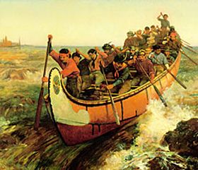
On May 14, 1804, Lewis and Clark left St. Louis, Missouri, with 45 men, a 55-foot keelboat, and two large canoes to trace the Missouri River to its headwaters for the first time. A few months later, they reached the headwaters of the Missouri River, at the confluence of the Jefferson, Madison, and Gallatin Rivers. Meriwether Lewis would write in his journal on July 28, 1805:
“Both Capt. C. and I corresponded in opinion with respect to the impropriety of calling either of these [three] streams the Missouri and accordingly agreed to name them after the President of the United States and the Secretaries of the Treasury and State.”
Later, after following the Jefferson River to the Beaverhead River and the Continental Divide, they believed they were nearing the headwaters of the Missouri River. However, when Meriwether Lewis ascends the final ridge toward the Continental Divide, expecting to see plains and a river flowing to the Pacific, he finds even more mountains.
But long before Lewis and Clark made their famous explorations, early trappers and traders were following the Missouri River. The first Europeans to see the river were the French explorers Louis Jolliet and Father Jacques Marquette. A misconception about the naming of the river and the state of Missouri comes from Father Jacques Marquette, who called the river “Pekitanoui”, meaning “muddy,” in May 1673. In actuality, the river and the state were named after the Siouan Indian tribe, whose Illinois name, Ouemessourita, means “those who have dugout canoes”. Over the years, the river has also been called the Big River, Big Muddy, Emasulia sipiwi, Eomitai, Katapan Mene Shoska, Le Riviere des Missouri, Mini Sose, Missoury River, Ni-sho-dse, Nudarcha, Rio Misuri, Riviere de Pekitanoni, Riviere de Saint Philippe, Le Missouri, Le Riviere des Osages, Missures Flu, Miz-zou-rye River, Niutaci, Pekitanoui, River of the West, and Yellow River.
French Explorers.
For the next several decades, the Missouri River remained unexplored and uncharted until Étienne de Veniard and Sieur de Bourgmont began to travel upstream, writing descriptions in 1713 and 1714. Bourgmont was the first to use the name “Missouri” to refer to the river, and he and Etienne de Veniard would later establish the first fort on the Missouri River in 1723. Fort Orleans was built somewhere around the mouth of the Grand River near Brunswick, Missouri, and was named for the Duke of Orléans.
It is unclear how far up the Missouri River Bourgmont traveled, but he was also the first European to discover the Platte River. The Spanish acquired control of the Missouri River in the 1763 Treaty of Paris, which ended the French and Indian War. However, they did not extensively explore the river and continued to allow French fur traders to work along the waterway.
The most significant expedition before Lewis and Clark was the MacKay and Evans Expedition of 1795-1797. James MacKay and John Evans were hired by the Spanish to search for a route to the Pacific Ocean and to tell the British to leave the upper Missouri River area. McKay and Evans created a detailed map of the upper Missouri that Lewis and Clark would later use.
Later, the Missouri River became the jumping-off point for all of the major trails that opened the American West, including the California, Mormon, Oregon, and Santa Fe Trails, as well as the Pony Express at St. Joseph, Missouri. The first bridge built across the Mighty Missouri was the Hannibal Bridge in Kansas City in 1869. Soon, paddle steamers began to move up the river, facilitating settlement in the Dakotas and Montana. The northernmost navigable point on the Missouri before extensive navigation improvements was at Fort Benton, Montana.
Over the next century, numerous dams, dikes, and levees were built along the river for flood control, and today, 35% of the river is impounded. In fact, the only significant stretch of the free-flowing river today is at the Missouri National Recreational River, a 100-mile National Park that runs between Gavins Point Dam and Ponca State Park, Nebraska, along the Nebraska-South Dakota border. The park is among the last unspoiled stretches of the Missouri River, and exhibits the islands, bars, chutes, and snags that once characterized the “Mighty Mo.” It also preserves the historic ruins of Fort Randall; Spirit Mound, an important cultural landmark to the Native Americans; and the Meridian Bridge, an engineering marvel of the 1920s.
More Information:
Missouri National Recreational River
P. O. Box 591
O’Neill, Nebraska 68763
402-667-2550
©Kathy Alexander/Legends of America, updated January 2026.
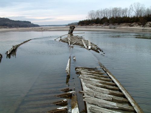
Ruins of the North Alabama steamship on the Missouri River.
Also See:
Corps of Discovery – The Lewis & Clark Expedition
Overland Trails of the American West
Quest for Treasure in the Missouri River
Upper Missouri River Breaks National Monument
See Sources.