
Midland Trail Map, 1924.
The Midland Trail, also called the Roosevelt Midland Trail, was a national auto trail spanning the United States from Washington, D.C., West to Los Angeles and San Francisco, California. The first road signed in 1913 was one of the first, if not the first, marked transcontinental auto trails in America.
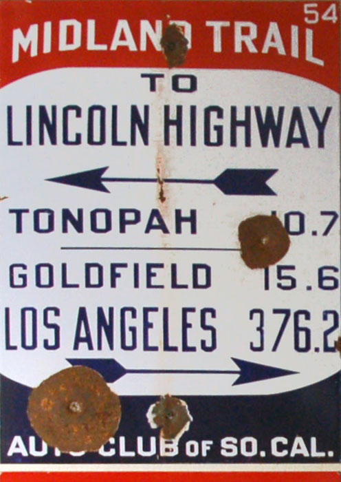
Midland Trail Sign.
The National Highways Association was established in 1911 to promote the development of an improved national road network in the United States. Under the slogan “Good roads for everyone!”, the National Highways Association advocated the federal government’s construction and permanent maintenance of a 50,000-mile highway system. This system was to comprise six main national highways, 13 national trunk highways, and 40 link highways. The link highways, the Association explained, would connect “the Mains and Trunks” and reach out “in all directions until the country as a whole is covered with almost a spider-web tracery of highways.”
The early routing of the Midland Trail, from East to West, began in Washington, D.C., and continued through Richmond and Clifton Forge, Virginia, to Charleston, West Virginia, and passed on through Morehead, Kentucky to Lexington and Louisville, Kentucky; Vincennes, Indiana; Salem, Illinois; St. Louis, Sedalia, and Kansas City, Missouri, to Topeka, Kansas; to Limon and Denver, Colorado.
From Denver, the original route split several ways to cross the Rocky Mountains via Berthoud Pass, Tennessee Pass, Cochetopa Pass, and Monarch Pass. All routes converged in Grand Junction, Colorado, and continued into Utah through Green River and Salt Lake City. The route then moved southward across the Salt Lake Desert through Iosepa, Orr’s Ranch, Fish Springs Ranch, and Ibapah, Utah.
In central Nevada, the highway continued across the Great Basin Desert through Ely and Tonopah, then turned south at Goldfield in the Amargosa Desert, West into California at Lida, and over the Inyo Mountains and the White Mountains through Westgard Pass.

Hawk’s Nest, West Virginia, on the Midland Trail.
At the junction in Big Pine, California, in the Owens Valley, the original routing then split into four options:
— One route through Mammoth Lakes, Mono Lake, Yosemite, and Stockton to San Francisco.
— The second is through Bridgeport, California, Lake Tahoe, and Placerville, to Sacramento, and then to San Francisco.
— The third went south through Independence and Mojave in the Mojave Desert, West through Tehachapi Pass to the San Joaquin Valley, and northward through Merced and Modesto to San Francisco.
— The fourth continued southward from Mojave through Willow Springs to Los Angeles. By the time the Automobile Club of Southern California had prepared its 1917 state map, the fourth routing, through Mojave and Willow Springs to Los Angeles, had become the primary routing for the Midland Trail in California.
The National Midland Trail Road Association published the official Midland Trail Tour Guide 1916, with explicit mile-by-mile directions for both East and West routes from Washington, D.C., to San Francisco.

1913 Dirt Road.
By 1926, there were over 250 named highways; this was a traveler’s nightmare of deciphering specific locations, distances, travel times, and other touring logistics. That year, the National Highway Association replaced highway names with numbers… a merciful gesture and improvement for travelers. Soon after that, the memory and name of the Midland Trail eroded into history.
Using the present road names, the highway approximately used the following route:
U.S. Route 60, Newport News, Virginia, to Richmond, Virginia
U.S. Route 1, State Route 54 in Virginia, U.S. Route 33, State Route 22 in Virginia, and U.S. Route 250, Richmond to Staunton, Virginia
Two alternate routes – U.S. Route 11 and U.S. Route 60 or State Route 42 in Virginia, State Route 39 in Virginia, and U.S. Route 220, Staunton to Covington, Virginia
U.S. Route 60, Covington to Louisville, Kentucky
U.S. Route 150 and U.S. Route 50, Louisville to Kansas City, Missouri
K-10 in Kansas and U.S. Route 24, Kansas City to Limon, Colorado
U.S. Route 40, Limon to Denver, Colorado
U.S. Route 40, Denver, former Colorado State Highway 11, U.S. Route 6, and U.S. Route 89, to Salt Lake City
Old Lincoln Highway, Salt Lake City to Ely, Nevada
An alternate route, approved in 1922, followed U.S. Route 6 from Santaquin, Utah (south of Salt Lake City) to Ely.
U.S. Route 6, Ely, Nevada, U.S. Route 395, State Route 14 in California, and San Fernando Road, San Fernando Valley, to Los Angeles.

Midland Trail in the Mojave Desert, California.
©Kathy Alexander/Legends of America, updated June 2026.
Also See:
Sources: