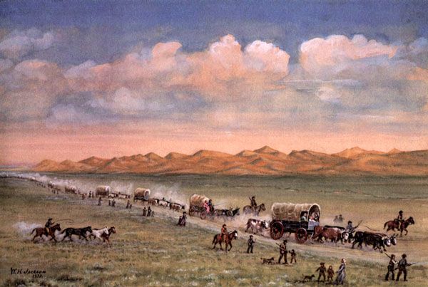
Oregon Trail pioneers pass through the sandhills, painting by William Henry Jackson.
As hopeful travelers set out on the overland trails in the 1840s and 1850s, they looked forward to the fertile farmland of Oregon and to the start of a new life. Although their eyes were fixed on their goal, they faced hardships and saw landmarks that stayed in their memories for the rest of their lives.
Those who started their overland journey near Independence, Missouri, followed the old Santa Fe Trail for about 40 miles until the Oregon Trail branched off to the northwest. They crossed small rivers, including the Big Blue, near a lovely camp called Alcove Spring in Kansas. Edwin Bryant recorded in 1846 that the water was “as cold and pure as if it had just been melted from ice.” The area was beautifully covered with tall grass and wildflowers but swarmed with mosquitoes, which some travelers, with typical exaggeration, insisted were as large as turkeys.
The emigrants followed the Little Blue River until they reached the Platte River in Nebraska. After 1848, they stopped briefly at Fort Kearny, the first of several forts they encountered along the trail. Although the fort was merely a group of rugged adobe buildings, it was a place of great importance where emigrants purchased supplies, shod animals, and mailed letters. The emigrants noted its unusual qualities as the wagons rolled out along the Platte River. It was often over a mile wide, yet only a few feet deep. The word “Platte,” derived from the word “flat,” perfectly described the terrain the overlanders encountered.
After crossing the South Platte River, they began heading toward the North Platte, traveling down the steep slope now called Windlass Hill. To one emigrant, this slope seemed “a little past perpendicular.” It was so treacherous that it claimed many wagons; travelers tried to slow their vehicles down any way they could. Although they apparently used no windlasses, they often chained the wheels and either locked or tied a small tree behind the wagon to provide resistance. Some even traveled an extra 16-17 miles to avoid the hill altogether.
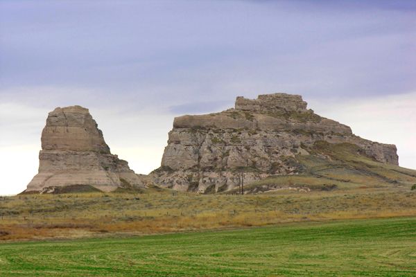
Courthouse and Jail Rocks on the Oregon Trail in Nebraska.
A few miles further along the trail, emigrants began to see incredible rock formations. Almost every journal noted these significant landmarks, the first of which was Courthouse Rock. This large butte reminded emigrants of courthouse buildings in numerous hometowns across the Midwest. A smaller rock beside this formation was named Jail Rock. Rock formations so enthused the emigrants that many traveled several miles off the trail to take a closer look and inscribe their names upon them.
A bit farther along the trail, emigrants encountered Chimney Rock. “The only way I can describe it,” wrote S.E. Hardy in 1850, “is it looks like a big sweet potato hill with a pile of rocks on top, something like a chimney.” The tip of the rock could be seen as early as three days before arrival. Watching Chimney Rock, a traveler could see that progress was slow. Chimney Rock was about 425 feet tall (50 feet higher than it stands today) and consisted of loose clay and volcanic
ash.
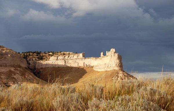
Scott’s Bluff, Nebraska, on the Oregon Trail.
Further along the North Platte River, emigrants came upon a prominent hill called Scott’s Bluff, blocking their path. This bluff received its name from early fur traders in the area. As the story goes, in 1828 or 1829, a trader named Hiram Scott became deathly ill and was abandoned by his companions, traveling 60 miles before dying. His skeleton was found at the foot of the bluff a few months later. Before 1851, wagon trains had to veer several miles to the south through Robidoux Pass. After the army improved the way, Mitchell Pass became the route of choice.
Beyond, one could see the faint purple shadows of the Rocky Mountains on the horizon to the West; Fort Laramie was just around the bend. Originally called Fort William, the fort was built by fur trader William Sublette in 1834 to trade with Native Americans. The American Fur Company purchased it two years later, enlarged the structure with adobe, and named it Fort John. The post was often referred to as Fort Laramie; however, it was named after a French-Canadian trapper, Jacques LaRames, whose name stuck. Like several forts along the Oregon Trail, it was purchased by the army in 1849 and converted into a military outpost. The one thing emigrants remembered most about the fort was the incredibly high prices for supplies. Tobacco, which might cost 5 cents in St. Louis, cost a full dollar at Fort Laramie!
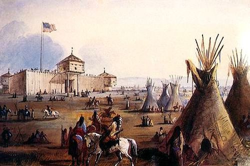
Fort Laramie, Wyoming, painting by Alfred Jacob Miller.
Leaving the fort, emigrants set out across present-day Wyoming, entering a land poisoned with alkali. Oxen had to be beaten away from the contaminated water, and many lost their animals along this stretch. The emigrants reached potable water at the Sweetwater River.
Independence Rock was soon sighted, which “at a distance looks like a huge whale,” noted J. Goldsborough Bruff in 1849. “It is painted and marked in every way, all over, with names, dates, initials, Ec.” Independence Rock, 128 feet high and one-quarter mile long, was covered with over 5,000 names from early travelers, enough to earn it the nickname “Great Desert Register.”
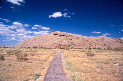
Independence Rock, Wyoming.
Names were chiseled, scratched, or painted on the white feldspar and granite with wagon grease and gunpowder. Some entrepreneurs charged as much as $5 to create “autographs” for the illiterate. How Independence Rock originally got its name is unknown. It may have been because it stands alone, independent of other formations, or because early trappers celebrated the 4th of July there. Overlanders tried to arrive at the rock by July 4 to ensure they would make it through the mountains before the winter snow.
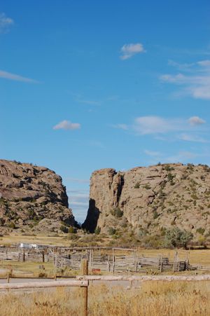
Devil’s Gate, Wyoming, on the Oregon Trail.
Just six miles down the trail, the emigrants saw Devil’s Gate, another rock formation with a vast, narrow cleft, 370 feet high, through which the Sweetwater River ran. Since the wagons couldn’t get through the narrow defile, they traveled half a mile to the south. The gorge received its name from an old Arapaho legend about a powerful evil spirit with huge tusks that once roamed the Sweetwater Valley. When warriors attacked the beast, it thrust up its tusks and ripped a massive gap through the earth, into which it disappeared.
The next and perhaps most significant landmark for the travelers was South Pass, a flat, gently sloping saddle nearly 30 miles wide through the Rocky Mountains. Many recognized that without this pass, the Oregon Trail would not exist. Although many travelers passed it without realizing it, it was an important point along the journey. Here, overlanders reached the halfway mark and crossed the continental divide.
After the South Pass, some emigrants left the main trail and followed the Sublette Cutoff, which eliminated about 75 miles of travel but went through a waterless desert. Most followed the overland trail southwest past Fort Bridger instead. This fort, built by Jim Bridger and Louis Vasquez in the early 1840s, sought to capitalize on overland travel after the demise of the fur trade. The main structure of Adobe was crude and shabby compared with other forts. The Mormon Trail branched off near Fort Bridger toward the Great Salt Lake, and in 1855, the Mormons purchased the fort. The U.S. government took over the area and constructed a new fort in 1858.
After the Sublette Cutoff and the main trail were reunited, emigrants encountered Soda Springs, where mineral deposits formed a landscape of cones, craters, springs, and geysers. Most emigrants tried the carbonated water, and some experimented by adding flavorings, sugar, and citrus syrup, which was a particular favorite. One geyser-like water source was named Steamboat Spring since it spewed water periodically, puffing like a great steamboat. Some mountain men swore they became intoxicated when they drank at another area called Beer Spring. However, most thought the water tasted a bit heavy on the sulfur.

Snake River.
As travelers neared the Snake River, they passed Fort Hall, built by Nathaniel Wyeth in 1834 as a fur trading post. After following the treacherous and winding Snake River for some time, wagon trains passed through a narrow break in the rocks called the “Gate of Death.”
From the Snake River, emigrants saw a chain of hazy blue shadows on the horizon, the Blue Mountains. Luckily, crossing through these mountains was surprisingly easy, unlike their next challenge, the treacherous Dalles rapids on the Columbia River in Oregon. The river dropped into a kind of sink filled with incredible boulders at the Dalles. The French called it “La Dalles,” meaning “the trough.” Here, just 100 miles from their goal in the Willamette Valley, travelers faced a great land barrier and no choice but to brave the rapids aboard makeshift rivercraft. Luckily, at the end of the harsh water route, emigrants received help from Dr. John McLoughlin, the “Father of Oregon,” in charge of operations at British Fort Vancouver.
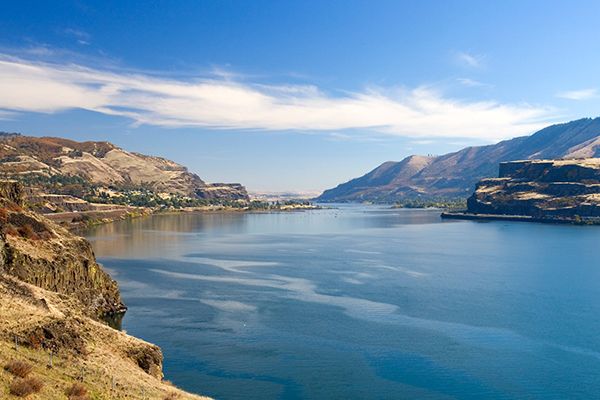
Columbia River.
By 1846, the emigrants were offered a choice when they approached the Dalles and could take a new trail around Mount Hood to the south, cleared by emigrant Samuel Barlow. In its early years, this route, called the Barlow Road, charged a $5 toll for a wagon and team. Although the charge was steep, most chose to take the road, avoiding the Columbia rapids. The road presented its own hazards. Its first section was so steep that wagons were often lowered with ropes, and decades after the road was abandoned, rope scars could still be seen on several trees. The road was about 90 miles long and took travelers about two weeks to reach their destination, the fertile soil of the Willamette Valley in Oregon.
“Upon the whole, I enjoyed the trip,” recorded Catherine Haun, “despite its hardships and dangers… Like every other pioneer, I love to live over again in memory of those romantic months and revisit, in fancy, the journey scenes.” When they reached Oregon, the emigrants had little to show for their long trip. Often, they were running dangerously low on supplies and money. However, they arrived in Oregon with something very valuable: their lives and the memories of the scenes they had experienced along the trail. Just as the landmarks they encountered had shaped the land, their experiences shaped our country’s future.
Compiled and edited by Kathy Alexander/Legends of America, updated June 2026.
Also See:
Oregon Trail – Pathway to the West
Oregon-California Trail Across Wyoming
Oregon Trail Through the Platte River Valley, Nebraska
Source: Jefferson National Expansion Memorial