
Questa, New Mexico by Kathy Alexander.
Located in the Sangre de Cristo Mountains, Questa, New Mexico, is a village in northern Taos County. The village is on the Enchanted Circle Scenic Byway, near the confluence of the Rio Grande and the Red River.

Paleo Indian People.
The first people to roam the area were the Paleo-Indian Clovis and later the Folsom people. However, permanent settlements were not established until about 5000 BC, when natives began to follow the big game as temperatures warmed. Before long, trails were blazed through the region, and the Questa area became a crossroads for hunting and trading. One of these was the Kiowa Trail, which paralleled the western face of the rugged Sangre de Cristo Mountains. Also called the El Camino de los Kiowas, Taos Mountain Trail, Trapper’s Trail, Tewa Trail, and Sangre de Cristo Trail, the path, on the east side of the deep Rio Grande Gorge, made its way from the buffalo hunting pastures of the Kiowa-Rita Blanca National Grasslands east of the Rocky Mountains to the trading center at Taos Pueblo. Archaeological studies show that the trail began to be used about 5,200 years ago and continued to be traveled until the late 1800s by the Archaic, Anasazi, Kiowa, Comanche, Puebloan, Ute, and Apache cultures.
In about 1150, El Pueblito was established at the mouth of Red River Canyon by the ancestors of the Taos Pueblo people. The village was located on the level hilltop at the mouth of Red River Canyon, which overlooks the valley to the west, with the Red River and Cabresto Creek below. This site was a long-used campsite along the Kiowa Trail. These people built pit houses, above-ground work areas, and adobe-style rooms on the surface. Archaeological evidence shows that they used metates and manos made of granitic sandstone for grinding and crushing seeds, nuts, and other plant or mineral materials collected in our rich surroundings. They also began making pottery from local clays, growing crops in the valleys below, and using the bow and arrow for hunting in the pastures and mountains. El Pueblito soon became a trading and travel center, with traders, hunters, and travelers from north and south along the Kiowa Trail that connected with other major trails. Evidence of this route can still be found in trail remnants, artifacts, and petroglyphs along the western slopes of the Sangre de Cristo Mountains.

Francisco Vasquez de Coronado
These early Puebloans were gone from the site by about 1225, and afterward, its location with two nearby rivers and both pasturable and farming land nearby was soon replaced and covered over by those who came after.
Francisco Vasquez de Coronado may have been the first Spanish visitor to the area, traveling through in 1540. In 1593, gold-seekers Juan Humana and Francisco Borilla were killed by tribes along the Purgatoire River. Spanish colonization of northern New Mexico began in 1598. By the 1600s, the Kiowa, Jicarilla Apache, and Ute used the old Pueblito walls for their camps. In 1694, Diego de Vargas reported an Apache farming village overlooking the Rio Colorado (Red River) on the Kiowa Trail. Later accounts from the Spanish Army traveling on the trail in the mid-1700s and early 1800s mention native people living in an abandoned village along the Rio Colorado, the low ruins of which reportedly stood in 1887. Today, this lost pueblo site is located in the Questa VFW (Veterans of Foreign Wars) cemetery that was established in 1933.
The Pueblo Revolt in 1680 cast the Spanish out of New Mexico. Afterward, Spanish occupation was slow to return to the Questa area due to repeated clashes with Taos and Ute warriors. However, trading and military activity continued, especially by French, French-Canadian, and English fur traders.

Indian Raid.
Around 1800, Spanish soldiers came north with settlers. They established a few tentative settlements in the area, and Hispanic settlers from Taos began moving north, seeking new grazing land for sheep and goats. However, settlers were vulnerable to Ute Indian raids.
In the early 19th century, the first settlers began traveling across the Kiowa Trail, and in 1815, 50 settlers received the first Questa-area land grant.
A permanent settlement called Rio Colorado was established in 1820. However, the village’s location at the confluence of the rivers along the ancient trade, raiding, and hunting routes made conflict inevitable, leading to its repeated abandonment. Spanish, Mexican, and eventually American soldiers tasked with defending the beleaguered settlement frequently expressed incredible frustration with their posting.
After Mexico gained its independence from Spain in 1821, U.S. trade opened along the Santa Fe and Old Spanish Trail. In the following decades, many Americans and Europeans began to travel through and settle in the area.

Entering Questa, New Mexico by Kathy Alexander.
The San Antonio del Rio Colorado land grant, encompassing Questa, was initially requested from Mexico in 1841. The petition was granted to 35 families in January 1842 by Juan Antonio Martinez. That year, the village of Rio Colorado was officially founded, and a wall was built around the plaza that offered some protection to area settlers. Additionally, guards were stationed atop two prominent peaks overlooking the village — Flag Mountain and Sentinel Peak. During that decade, numerous buildings were constructed on the mesa rather than down along the river.
Construction of the San Antonio Church began in 1842, but it would take years before it was completed.
In 1845, soldiers were sent to the area to protect the settlers from Cheyenne raids. More troops were sent at the beginning of the Mexican-American War in 1846. When America won the war, the Treaty of Guadalupe de Hildago upheld the land grants, and by 1849, 100 families were living in the village. In 1851, New Mexico became a territory, land grants were disputed, and the U.S. cavalry continued to protect the settlers from Indian raids.

San Antonio Church in Questa, New Mexico by John Collier, 1943.
In 1860, Bishop Lamy visited Rio Colorado, noting “the beautiful new church on the plaza’s north side.”
When a post office was established in 1883, the town’s name was changed from Rio Colorado to “Questa.” It was meant to be spelled Cuesta, Spanish for “ridge” or “slope,” but the postmaster misspelled the name.
Finally, the close of the 19th century saw an end to the Indian wars. The railroad’s arrival north of Questa, just over the Colorado border, ended the long-term trade and barter economy as more manufactured goods became available in the region.
Though the mountains of northern New Mexico saw much hard-rock prospecting in the 1800s, the area mines of gold, silver, copper, and lead were abandoned by 1900. However, molybdenum was discovered in the Questa district along the Red River in about 1914. The first mining claims, equaling an area of 200 acres, for this soft blue-black mineral were staked that year.

Questa, New Mexico Molybdenum Mine, courtesy the Santa Fe New Mexican.
Molybdenum is used as a hardening agent in the steel industry, including cast-iron engine blocks, energy pipelines, oil platforms, and medical equipment. It is also used in pigments, lubricants, and petroleum catalysts. It is also used in everyday residential items such as automobiles, cast iron, and gardening tools.
By 1918, the R and S Molybdenum Mining Company began underground mining of high-grade veins. The ore, a bit softer than a pencil lead, was hand-drilled and hauled several miles by horse and mule-drawn wagons to the June Bug Mill, the relocated gold mill from Elizabethtown. Even this labor-intensive method eventually produced 50 tons of ore per day.
The company was reorganized in 1919, and its name was changed to the Molybdenum Corporation of America in 1921. Additional property was purchased, and the mine expanded from 200 acres to 14,300 acres. Before long, the company was milling 50 tons of ore per day. The miners and their families lived onsite in a self-contained company town. In 1923, Molycorp built a processing mill, one of the first flotation mills in North America.
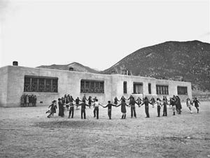
The Works Progress Administration built the elementary school in Questa, New Mexico, during the Great Depression.
Questa weathered the Great Depression with the aid of the Work Progress Administration (WPA), which employed locals to build the Fish Hatchery and an elementary school.
Underground mining of high-grade vein ore occurred from 1919 to 1958. By the mid-1950s, 50 miles of tunnels had been excavated when the seam began to run out. However, exploration continued from 1953 to 1964, when open-pit mining commenced, and a new mill was built. From 1965 to 1982, the company mined some 81 million tons of ore from its open-pit mine. In 1975, deeper deposits were found underground, and two years later, Molycorp was bought by Union Oil Company of California (later named Unocal). A ten-year, $250-million project transitioned the mine to go underground again in 1982.
Molycorp continued mining through 1986, when poor market conditions temporarily shut down the mine until 1989. Mining operations were again placed on standby in 1992 and resumed in 1995. In early April 2005, Chevron-Texaco announced the purchase of Unocal, including Molycorp, Inc., and in October 2007, Molycorp, Inc. officially became Chevron Mining Inc.
The mine continued to function until June 1, 2014, when its employees were called together and told the mine was closed forever. This proved catastrophic economically for many Questa families.

Questa, New Mexico Street by Russell Lee, 1939. Colorized by Kathy Alexander.
At its peak, the mine operated 24 hours a day, seven days a week, all year long. Questa’s mine accounted for 10% of worldwide production and 15% of U.S. consumption for a time. During its operation, miners pulled approximately 100 million tons of molybdenum ore out of the ground.
Over the years, the mine has provided significant economic opportunities for residents. It was once the largest private employer in Taos County, with as many as 750 workers. The mine’s owners also funded the village’s infrastructure, including a local park, streetlights, and the new solar array.
However, the mine also polluted the Red River and local watershed, posing potential health risks to both employees and area residents through the dangers of daily mining operations and exposure to mine-related pollution of local water, air, and land. In its years of operation, it also left behind metal-laden tailings, 328 million tons of waste rock, a nine-mile-long pipeline that carried acidic waste from the mill to lagoons, collapse zones from underground tunneling, and heavy machinery and milling buildings.

Questa, New Mexico mine tailings by Kathy Alexander.
For some years, it was well known that the mine was careless in disposing of its waste, with multiple spills from tailings and pipelines that flooded the land and poured into the Red River and acequias (irrigation ditches). This became so bad that in the 1980s, the Red River began to turn cloudy blue, representing acid drainage and high metal content. It also killed the fish in one of the best-known trout streams in the WesWesturing those years, the accumulating dust from the tailings just west of town created blinding storms that shut down schools, canceled events, and caused respiratory problems for area residents.
Though the authorities made reports and the mine owners were fined for violations, little was done to correct the problem.
Finally, the molybdenum mine was declared a Superfund Cleanup Site by the Environmental Protection Agency in 2009
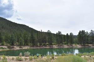
Eagle Rock Lake in Questa, New Mexico by Kathy Alexander.
Chevron then stepped in to provide remediation, beginning with building an onsite treatment plant to prevent further runoff or seepage of contaminants. They also drained, dredged, lined, and landscaped the popular Eagle Rock Lake east of the village on the banks of the Red River. Groundwater in Questa and the waters of the Red River are now reportedly clean. In 2016, the Justice Department, EPA, and the State of New Mexico announced a cleanup settlement of $143 million. Chevron has also led the efforts toward a brighter and cleaner future in northern New Mexico, building a 20-acre solar farm adjacent to their obsolete tailings ponds where contaminated soil and water have been removed. It provides enough power for Questa to live off the grid during daylight hours.
Today, Questa’s primary economic means is agriculture. Alfalfa, hay, and winter wheat are in the fields, and some are beginning to supply a growing market for organic goods. Cattle herds have mostly replaced traditional sheep herds. Many residents also commute to Taos and Red River to work in the hospitality industry.

Business building in Questa, New Mexico by Kathy Alexander.
It has also become a destination for outdoor enthusiasts, from anglers to hikers, artists, and equestrians.
Cradled by the Sangre de Cristo scenic mountains, valleys, and mesas, the village is near the Rio Grande del Norte National Monument and the Carson National Forest. The Rio Grande del Norte National Monument has two popular locations: the La Junta Overlook, where the Rio Grande and the Red River come together over 800 feet below, and the Big Arsenic Trail, containing petroglyphs and a natural spring. Paralleling Questa to the east, the Carson National Forest provides trout fishing, mountain lakes, campgrounds, and the Columbine-Hondo and Latir Peak Wilderness areas. Just outside Questa’s Village limits is Eagle Rock Lake.

San Antonio de Padua Church in Questa, New Mexico by Kathy Alexander.
The historic San Antonio Church, which has stood at the center of the old plaza since the mid-1800s, continues to serve parishioners today. After the structure suffered a partial collapse several years ago, parishioners and residents gathered together to restore the adobe church to its former glory. The church is always open during daylight hours and welcomes all guests.
The village is home to about 1,750 people. Questa is located 24 miles north of Taos on New Mexico Highway 522.
©Kathy Alexander/Legends of America, updated May 2025.
Also See:
New Mexico – Land of Enchantment
Taos – Art, Architecture & History

Highway to Red River just outside of Questa, New Mexico by Kathy Alexander.
Sources:
Chevron
High Country News
New Mexico Tech
Questa History Trail
Questa, New Mexico
Wikipedia