
Vintage photo of a building in the Barrio Libre District of Tucson, Arizona. Colorized by Kathy Alexander.
Barrio Libre – Spanish for “free district,” Barrio Libre is Tucson’s major Spanish-speaking neighborhood and has played an important role in developing the city. Located just south of Presidio de San Agustín del Tucson (1775), one of Spain’s northern forts, Barrio Libre was established near a large natural spring, an important water supply. The district was initially settled by laborers from the Presidio and by ranchers who built their townhomes there. Many of the barrio’s residents became prominent citizens who helped shape Tucson’s development. The district’s most significant growth period came after the introduction of the railroad to Tucson in 1880. Between 1885 and 1900, dense rows of adobe buildings were constructed along the barrio’s major thoroughfares. Barrio Libre retains 19th-century Hispanic urban form and architecture traditions, which are unchanged from its territorial appearance. The concentration of Sonoran, Transitional, and American Victorian adobes contributes to the district’s sense of timelessness. Barrio Libre is bounded by 14th, Stone, 19th, and Osborne Streets in downtown Tucson, Arizona.

White House, Canyon de Chelly, Arizona by Mark Kuhanek.
Canyon de Chelly National Monument – Canyon de Chelly National Monument (pronounced “canyon d’shay”) contains over 2500 archeological sites from 1500 B.C. to 1350 A.D. It is considered one of the oldest continuously occupied sites in North America. Among these sites are several hundred Anasazi Indian villages built between 350 and 1300 A.D. After 1100, the Anasazi built dramatic masonry cliff dwellings in caves and recesses in the canyon walls. The Anasazi began to vacate the canyons about 1300 A.D. Canyon de Chelly National Monument, administered by the National Park Service, is three miles east of Chinle, Arizona, off US 191 on Arizona Route 7. Except for a self-guided trail from the White House Overlook to the White House Ruin, all visitors must be accompanied by a park ranger or an authorized guide. See Full Article HERE.

Casa Grande Ruins, Arizona by Kathy Alexander.
Casa Grande Ruins National Monument – Casa Grande, administered by the National Park Service, is one of the most intriguing prehistoric ruins in the United States. Built by the Hohokam Indians in the Gila Valley sometime between 1150 and 1350 A.D., the four-story building and outlying structures may have been used as dwellings, a ceremonial site, or possibly an astronomical observatory. By 1450, for reasons still unknown, Casa Grande was abandoned. The Jesuit priest Father Eusebio Kino visited the site in 1694 and named it Casa Grande (Great House). In 1892, it became the first archaeological preserve in the United States. Casa Grande Ruins National Monument encompasses 60 prehistoric sites, including the Great House complex. Casa Grande Ruins National Monument is situated in Coolidge, Arizona, off AZ 87. A Visitor’s Center has interpretive exhibits. Self-guided tours and ranger-conducted talks are available.

Coronado National Memorial by the National Park Service.
Coronado National Memorial commemorates the first major European exploration of the American Southwest, the 1540-1542 expedition led by Francisco Vásquez de Coronado. The expedition searched for the seven mythical gold Cities of Cíbola, rumored to be north of Mexico. Although the Spanish government ultimately considered the expedition a failure, it is historically viewed as a success because it opened territories north of Mexico and led Spain to colonize the American Southwest. The nearly 5,000-acre Memorial lies on the U.S.-Mexican border within sight of San Pedro Valley, where historians believe Coronado entered the present United States. The scenic overlook at Montezuma Pass offers spectacular views of the surrounding countryside. Administered by the National Park Service, Coronado National Memorial is 21 miles south of Sierra Vista, Arizona, five miles off Arizona Highway 92. Both road and hiking trails access the overlook. From there, a short interpretive trail leads to Coronado Peak.
El Presidio Historic District – This district is a residential neighborhood containing adobe and brick buildings in the Spanish-Mexican, Anglo-American, and Eclectic architectural styles. Named for the Spanish-built Presidio de San Augustín del Tucson (1775), El Presidio is one of the nation’s oldest inhabited sites. The district is on a prehistoric Hohokam Indian site (c. 700-900 A.D.) and the original presidio (fort). The El Presidio Historic District reflects Tucson’s development from an 18th-century walled compound to a significant 20th-century mercantile center. W. 6th St., W. Alameda St., N. Stone Ave., and Granada Ave. in downtown Tucson, Arizona roughly bound the Presidio Historic District.

Apache Wikiup at Fort Bowie, Arizona, by Kathy Alexander.
Fort Apache Historic District – Constructed between 1874 and 1932, the District encompasses the original site of the Fort Apache military post. Fort Apache was a significant outpost during the Apache wars (1861-1886) and remained a military post until 1922. In 1923, the fort became the site of the Theodore Roosevelt Indian School. The district contains over 30 structures, ranging from reconstructed early log buildings to original two-story dormitories. Also included are a headquarters building, sleeping quarters, corrals, storehouses, a guardhouse, a magazine, stables, an old military cemetery, and prehistoric ruins. Fort Apache Historic District is four miles south of Whiteriver, Arizona, off Arizona 73 on the Fort Apache Indian Reservation. See Full Article HERE.

Fort Bowie, Arizona Stage Station Ruins by Kathy Alexander.
Fort Bowie – This fort was built in 1862 in the Chiricahua Mountains to protect the U.S. Mail route and settlers heading west to the California goldfields. The fort served as the base of operations during the Apache Wars (1861-1886), the U.S. Army’s ultimately successful series of campaigns to quell raiding and warfare by the Chiricahua Apache in Arizona and Mexico. Fort Bowie was officially abandoned in 1894. The area includes stabilized adobe walls from the fort’s many buildings, the stone foundations of the Apache Pass Station of the Butterfield Overland Mail Route, and the post cemetery. Fort Bowie National Historic Site is 12 miles south of Bowie, Arizona, at Apache Pass. The site can only be reached by walking the last 1.5 miles. See Full Article HERE.

Fort Huachuca, Arizona Museum.
Fort Huachuca – Constructed in 1877, this post was one of a chain of forts established to guard southern Arizona against the Chiricahua Apache, led by Geronimo. Here, the Army organized an elite strike force that chased Geronimo and his followers through Mexico’s Sierra Madre during the summer of 1886, compelling their surrender. Fort Huachuca was also the headquarters of the famed 10th Cavalry, the “Buffalo Soldiers,” one of the Army’s elite black cavalry corps. Today, the fort is still an active Army post and covers more than 70,000 acres, 110 of which are the “Old Post Area.” This historic district contains many notable buildings, among them the Pershing House, an adobe structure built in 1884, traditionally the Post Commander’s quarters; the “Old Post” Barracks, built c. 1882-1883; Leonard Wood Hall, a large two-storied building, used as the hospital; and the Fort Huachuca Historical Museum, an adobe and stone building initially used as the post chapel. The National Historic Landmark is located four miles west of Sierra Vista, Arizona, on AZ 90. The Fort Huachuca Museum is three miles northwest of the fort’s main gate at Boyd and Grierson Avenues. Full Article HERE.

Hubbell Trading Post, courtesy Wikipedia.
Hubbell Trading Post – This trading post was founded in 1878 when John Lorenzo Hubbell bought out another trader, “Old Man” William Leonard. Trading posts played a unique role in reservation life, serving as a business, a social hub, and a point of contact with other communities and cultures. Hubbell worked closely with the Navajo weavers and silversmiths to find markets for their products. Often a spokesman to the outside world for the Navajo, Hubbell was one of the foremost traders of Navajo goods. Today, Hubbell Trading Post is the oldest continuously operating trading post in the Navajo Nation and is still a crossroads of cultures. Hubbell Trading Post National Historic Site, administered by the National Park Service, is on the Navajo Nation, one mile west of Ganado, Arizona. The Post can be reached by AZ 264 (Navajo Route 3) from the east/west and US 191 from the north/south. See Full Article HERE.
Juan Bautista de Anza National Historic Trail – This historic trail traces the route followed in 1775-1776 by Spanish commander Juan Bautista de Anza II, who led almost 300 colonists on an expedition from Mexico to found a presidio and mission near San Francisco Bay. The trail is over 1,200 miles long and can be traveled today via an auto tour. It commemorates, preserves, and invites visitors to explore elements of the Spanish colonization plan for its northernmost territory. The trail begins in Nogales, Arizona, and ends in San Francisco, California. Several sites along the trail are listed in the National Register of Historic Places. These include the Tumacácori National Historical Park, Mission San Xavier del Bac, Casa Grande Ruins National Monument, Presidio of San Ignacio de Tubac, Yuma Crossing State Historic Park, and several others in California.

Kinishba Ruins, Arizona.
Kinishba Ruins – A large pueblo ruin containing nine masonry buildings constructed between 1250 and 1350 A.D. by the pre-Columbian Mogollon culture. The pueblo is situated at the upper end of a grass-covered valley and originally had 400-500 ground-floor rooms, each standing two or three stories high. At its peak, Kinishba may have housed up to 1000 occupants. The pueblo was vacated in the late 14th to early 15th centuries for unknown reasons. Kinishba Ruins, a National Historic Landmark, is seven miles west of Whiteriver, Arizona, off AZ 73 on the Fort Apache Indian Reservation. The White Mountain Apache Tribe administers the ruins.
La Casa Cordova – Now a part of the Tucson Museum of Art, it may be the oldest surviving building in Tucson. The one-story adobe house is a typical Mexican townhouse design with a flat roof, a central brick courtyard, and doors opening directly onto the street. Possibly built as early as 1848, La Casa Cordova dates from the city’s Mexican period and is Tucson’s oldest residence. La Casa Cordova is located at 140 N. Main Ave., in the El Presidio Historic District, Tucson, Arizona, is operated by the Tucson Museum of Art.

Montezuma Castle by Kathy Alexander.
Montezuma Castle – Built by prehistoric Sinagua Indians in the early 1100s, the “castle” received its name from Anglo-American settlers who mistakenly believed that Aztec Indians had built it. Situated in a cliff recess 100 feet above the Verde Valley, Montezuma Castle is a five-story pueblo with 20 rooms, similar to the many Anasazi dwellings throughout the Southwest. Nearby is Castle A, a 45-room pueblo built at the base of the cliff. Montezuma Well, just north of the Pueblos, is a large limestone sink used as a water source for irrigation by the Pueblo inhabitants. In the early 1400s, the valley was vacated for unknown reasons. Montezuma Castle National Monument, administered by the National Park Service, is north of Camp Verde, Arizona, off I-17. A self-guided tour is available.

Betatakin Cliff Dwellings at Navajo National Monument in Arizona, by Jon Sullivan.
Navajo National Monument – Administered by the National Park Service, this monument contains three large prehistoric Anasazi Indian cliff dwellings constructed between 1200 and 1300 A.D. Keet Seel, with over 160 rooms including six kivas, is the largest cliff dwelling in Arizona; Betatakin Ruin has 135 rooms including living quarters, granaries and one kiva; and Inscription House, the smallest of the three, has 44 rooms, several granaries, and one kiva. (Inscription House is closed to the public.) The pueblos were vacated in the 1300s, probably due to erosion that depleted the soil on the canyon floor and lowered the water table. Navajo National Monument is 30 miles southwest of Kayenta, Arizona, off US 160 on Arizona 564. The Visitors Center is near the Betatakin Ruin site.

Old Governor’s Mansion in Prescott, Arizona, courtesy Wikipedia.
Old Governor’s Mansion/Sharlot Hall Museum -This large one-and-a-half-story rustic log building, constructed in 1864, served as the residence for the Territorial Governor and session hall for the Arizona Territorial Government. The building was later used as a home by Sharlot Hall, the State Historian and poet. The surrounding grounds are beautifully landscaped with fruit trees and rose gardens. The Old Governor’s Mansion/Sharlot Hall Museum is located at 415 W. Gurley St. in Prescott, Arizona.
Old Spanish Trail – After Mexico gained independence from Spanish rule in 1821, trade flourished between the eastern United States and the vast western territory. The trails developed as explorers, traders, and settlers sought safe passage through the treacherous, dry, and scorching-hot interior lands. The Old Spanish Trail developed during this period as Westerners sought to connect the burgeoning trading post at Santa Fe to the riches of Los Angeles and southern California. First officially established in 1829, the main branch of the trail spanned over 2,700 miles, cutting through the southwestern corner of Colorado, moving north and west through Utah, and finally turning south again toward Arizona and lower Nevada, with a terminus in Los Angeles, California. See Full Article HERE.

Petrified Logs at Petrified Forest National Park, Arizona, by Kathy Alexander.
Petrified Forest – The area designated Petrified Forest National Park has been occupied on and off for over 2000 years. While best known for its scenic natural wonders, the park has several fascinating cultural sites. Among these is the Newspaper Rock Petroglyphs Archeological District, which includes a significant collection of pre-Colombian Indian petroglyphs. Many design elements are inscribed on the rocks, including numerous human and animal forms. Also of note are Puerco Ruin and Petroglyphs, an Anasazi pueblo village compound (1250 to 1350 A.D.) containing over 100 rooms and kivas. Petroglyphs on the boulders lead to structures within the compound. Painted Desert Inn, a National Historic Landmark, is an original inn/trading post built in 1924 and rebuilt in the 1930s by the Civilian Conservation Corps (CCC).

Presidio de San Ignacio de Tubac.
Presidio of San Ignacio de Tubac – This fort was established in 1752 in response to the Pima Indian Rebellion, an uprising to protest forced labor in local mines and ranches. The Presidio (fort) was intended to protect the area’s various missions and quell further uprisings. Tubac is the oldest of the three Spanish presidios founded in Arizona and was once considered the region’s official capital. Today, the park and museum highlight the contributions of American Indians, Spaniards, Mexicans, and Anglo-Americans to Arizona’s history and development. Tubac Presidio State Historic Park is off I-19 in Tubac, Arizona, 45 miles south of Tucson. A museum containing American Indian and Spanish artifacts is located at the site.
Pueblo Grande Ruin – A National Historic Landmark, this ruin is a large prehistoric Hohokam Indian village site that was continuously occupied between 100 and 1450 A.D. Heavily influenced by contacts with Mexico, the Hohokam built a Central American-style ball court and a large masonry platform mound surrounded by caliche-brick dwellings between 1150 and 1450 A.D. The mound covers 3.3 acres and stands 20 feet high. The Pueblo Grande Museum contains exhibits on the Hohokam people. Pueblo Grande Ruin is located at 4619 E. Washington St. in Phoenix, Arizona. A self-guided trail leads to the ruin.

Mission San Xavier del Bac, Arizona.
San Xavier Del Bac – Called the “White Dove of the Desert,” it is one of the most beautiful mission church complexes in the Southwest. The original mission was founded in 1692 by Jesuit missionary Father Eusebio Francisco Kino to serve the Sobaipuri Indians (O’odham). The Franciscans built the present church between 1783 and 1797. Of Baroque design, the large stuccoed church has two bell towers, one of which is incomplete. The church’s beautiful front portal is decorated with scrolled ornaments and sculptures, and virtually the entire interior is covered with elaborately painted and sculpted surfaces. San Xavier Del Bac, a National Historic Landmark and functioning parish church, is 9 miles southwest of Tucson, Arizona, off I-19 on San Xavier Road on the San Xavier Reservation. A self-guided tour is available daily.
Tonto National Monument – Administered by the National Park Service, this monument contains three prehistoric Salado Indian cliff dwellings constructed c. 1250 to 1300 A.D. The monument consists of the Upper Ruin, with 32 ground-floor rooms and eight second-story rooms; the Lower Ruin, with 16 ground-floor rooms and three second-story rooms; and the Lower Ruin Annex. There are also at least 62 additional sites. The Salado were primarily farmers descended from the Hohokam who settled the Tonto Basin in the 700s. Between 1400 and 1450, for unknown reasons, the Salado vacated their cliff dwellings. Tonto National Monument is 31 miles northwest of Globe, Arizona, on Arizona 88. A Visitor’s Center and museum are open daily.

Tumacacori Mission south of Tucson, Arizona, by Carol Highsmith.
Tumacácori Mission (San José de Tumacácori) – Jesuit missionaries founded this mission in 1691. Constructed in 1757, the original mission included a small church and compound. In 1799, a more imposing church with a painted interior was built by Franciscan missionaries. Other sites in the mission compound include a small mortuary chapel, the convento (missionary residence) ruins, a granary, the remains of an Indian village, a historic cemetery, and the remains of the mission garden and orchard. Also located within the park’s jurisdiction are the ruins of San Cayetano de Calabazas, one of the mission’s visitas (satellite communities), and Los Santos Angeles de Guevavi, a church associated with the mission. Tumacácori National Historical Park, administered by the National Park Service, is 19 miles north of Nogales, Arizona, at exit 29 off I-19. A self-guided tour is available.
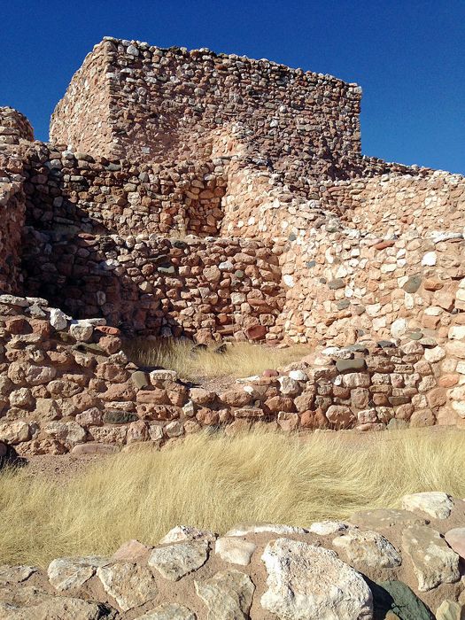
Tuzigoot Pueblo, Arizona, courtesy Wikipedia.
Tuzigoot National Monument – Tuzigoot is the remnant of a prehistoric Sinagua Indian pueblo constructed between 1125 and 1400 A.D. The pueblo is located on a steep hill overlooking the Verde River, one of the few permanent streams in Arizona. The Sinagua were sedentary farmers who appeared to have practiced floodwater agriculture. The Pueblo originally had 86 ground-floor rooms, some of which were two stories high, that were accessed via roof openings using ladders. In the early 1400s, the pueblo was vacated for unknown reasons. Tuzigoot National Monument, administered by the National Park Service, is two miles north of Cottonwood, Arizona, off Alternate Route 89.
Walnut Canyon National Monument – This historic monument has over 240 prehistoric Sinagua Indian sites. These include pit-house villages built between 500 and 800 A.D. and several multi-room cliff dwellings and single-room field houses built between 1125 and 1250 A.D. By about 1250 A.D., the Sinagua had moved on, leaving the sites as the most obvious reminders of their habitation. Walnut Canyon National Monument, administered by the National Park Service, is seven and a half miles east of Flagstaff, Arizona, off I-40.

Wupatki National Monument near Flagstaff, Arizona, by Dave Alexander.
Wupatki National Monument – This site comprises nearly 2,700 archeological sites. Most are Sinagua and Anasazi, dating from c. 100-1250 A.D. The two largest dwellings, built between 1100 and 1250 A.D., are Wupatki, with up to 100 rooms built against and atop a mesa, and Citadel, a 50-room structure that almost surrounds a central plaza. The Monument also contains many smaller pueblo ruins, pit houses, reservoirs, petroglyphs, and a masonry ball court. The pueblos were permanently vacated by about 1250 A.D., perhaps due to extended drought or over-utilization of natural resources. Wupatki National Monument is 35 miles north of Flagstaff, Arizona, off U.S. 89.
Yuma Crossing National Heritage Area -Yuma Crossing National Heritage Area is a cultural crossroads offering visitors a diverse and intriguing history. The first National Heritage Area west of the Mississippi covers 21 square miles and encompasses the town of Yuma, Arizona, near the California and Mexican borders.
©Kathy Alexander/Legends of America, updated April 2026.
Also See:
Missions & Presidios in the United States
Ghost Towns & Mining Camps in Arizona
See Sources.