
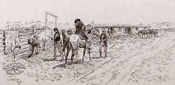
The Pony Express was running while the telegraph lines were being built. This drawing, by George M. Ottinger, appeared in Harper’s Weekly in 1867.
Division Two of the Pony Express Trail stretched from Fort Kearny, Nebraska, to Horseshoe Creek Station, Wyoming. This division extended through western Nebraska, a short ride through Colorado, and then returned to Nebraska and then into eastern Wyoming. It crossed the High Plains toward the Rocky Mountains and included more than 30 stations. This segment of the Pony Express was the same as the Oregon–California and Mormon Trails.
Seventeen Mile/Platte Station – In 1859, the Leavenworth & Pike’s Peak Express Company established a stagecoach station at Seventeen Mile Station to serve as the first stop for passengers after Fort Kearny. When the Central Overland California and Pike’s Peak Express assumed control of these stations and started the Pony Express, they likely made the Seventeen Mile Station a relay station. It was thought to have been located about five miles southeast of Odessa, Nebraska.
Garden Station – The exact identity and location of this site remains unknown. Historians have listed it as six miles southwest and six miles southeast of Elm Creek. It has also been called by several names, including Shakespeare’s, Sydenham’s Ranche, Biddleman’s Ranch, and Platte Stage Station. The 1861 Overland Mail Company contract listed the station as Garden. In 1865, the station was destroyed by fire.

Plum Creek Massacre Marker.
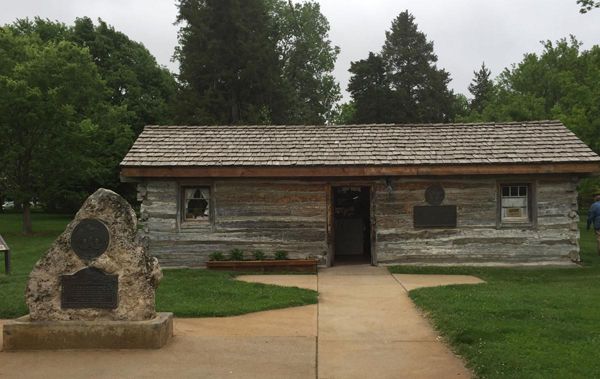
Plum Creek Station – Thought to have been located about ten miles southeast of Lexington, Nebraska, sources generally agree that this was a relay station. The site also featured Daniel Freeman’s trading post. In 1859, the Leavenworth & Pike’s Peak Express Company listed Plum Creek as a stop. Later, the station’s log structures housed a Pony Express station, a stage stop, and, even later, a telegraph station. Indian attacks on wagon trains and stagecoaches, including the Plum Creek Massacre, between 1864 and 1867, led to the establishment of a small garrison of troops at Plum Creek Station. Sometime after August 1867, the station was burned and abandoned. However, a cabin from the Plum Creek Pony Express Station may be seen in the city park in Lexington, Nebraska.
About five miles south of the station occurred the Plum Creek Massacre on August 8, 1864. Here, warriors attacked a Denver-bound wagon train, killing 13 men and capturing a woman and a boy. Although the cemetery commemorates the victims, they were buried elsewhere. The Plum Creek Massacre site and cemetery are about five miles south of Overton, Nebraska.
Willow Island/Willow Bend Station – This station was located approximately six miles southeast of Cozad, Nebraska, in Dawson County. The original cabin, built about 1849, was first located on the south bank of the Plate River south of Darr and used as a trading post. Later, it was moved and known as Willow Island Station. It was used for a stagecoach stop and the Pony Express. In 1866, the station’s structures included an adobe house, stables, and a frame store. Billy Campbell and Melville Baugh both were riders on this portion of the trail. Decades later, the Dawson County American Legion Post No. 77 purchased the station’s original log cabin and moved it to Cozad Park. Today, the Robert Henry Museum and Walkway commemorates the artist career of the town’s native son and preserves several historic buildings, including the Willow Island Pony Express Station.

Midway Ranch Pony Express Station, Nebraska.
Cold Water/Midway Ranch Station – The Cold Water Ranch/Midway Station site was probably four miles south of Gothenburg. Sources generally agree on its identity as a Pony Express and stage station, although opinions vary about its function as a relay or home station. Leavenworth & Pike’s Peak Express Company stages stopped at Cold Water, between Plum Creek and Cottonwood Springs. Frank Root, an Overland Mail Company messenger in the 1860s, noted the station’s name (Midway) came from its central location between Atchison and Denver. In 1863, David Trout managed station operations at Midway Station, also known as Heavy Timber, Smith’s East Ranch, and Pat Mullaly’s Home Station.
Questions arise about the possible existence of one of Cold Water Ranch/Midway’s log structures. Located four miles south of Gothenburg, a sturdy log cabin sits on the Lower 96 Ranch, which is said to be an original Pony Express building. The Oregon Trail Memorial Association recognized this building with a Pony Express bronze plaque, and a second bronze marker noted Pony Express rider Jim Moore’s emergency trip from Midway to Julesburg, Colorado, on June 8, 1860, during a time of Indian unrest. There is some dispute as to whether this was actually a station, as one witness in 1866 claimed to have seen Indians burn the station. Despite this apparent contradiction in the history of this structure, the cabin is listed on the National Register of Historic Places. It is open to visitors on a limited basis.
Gilman’s Station – There is some confusion on the exact location of Gilman’s Station. Descendants say the station was located on what was called the Pump on the Prairie Road Ranch. Most sources generally agree on the identity of Gilman’s Ranch as a relay station and a stage stop listed on the 1861 mail contract.
Pony Express Station Museum in Gothenburg, Nebraska, courtesy of the Lincoln Journal Star.
Machette’s Station (Gothenburg) – The identity and location of Machette’s Station remains controversial. Local tradition places the site on the Williams’ Upper 96 Ranch, four miles east of Fort McPherson in Lincoln County, Nebraska. Up until 1931, there was a two-story log cabin and a blacksmith shop linked to this site. However, in 1931, the American Legion Post No. 64 dismantled the main two-story log structure from the original site. It moved the log building to Ehman Park in Gothenburg, where it was reassembled into a one-story building. Tourism signs along the highway advertise the building as an original Pony Express station. A marker attached to the building tells visitors that Sam Machette built the cabin in 1854 as a trading post and ranch house, that the Pony Express used it from 1860-1861, and that it served as an overland stage station, dwelling, bunkhouse, and storage house on the Upper 96 Ranch afterward. Other researchers believe this cabin was part of a trailside road ranch on a route once used by the Pony Express, but it was not an actual Pony Express Station. The structure is now used as a Pony Express Museum.

Cottonwood Springs, Nebraska Pony Express marker.
Cottonwood Springs Station – The Cottonwood Springs Pony Express station site is thought to have been located about two miles west of Fort McPherson. The station, also known as McDonald’s Ranch and Box Elder, also served as a stop for the Leavenworth and Pike’s Peak Express Company stage line. The June 1860 census states that a man named John North was the station keeper for the Pony Express Company.
In 1864, author and soldier Eugene F. Ware described a two-story log structure at Cottonwood Springs, which could have served as the site of Cottonwood Station. In 1865, Lieutenant Colonel Sigreaves of the U.S. Army Engineers Topographical Corps sketched the area around Fort Cottonwood (Fort McPherson), showing a stage and telegraph office about two miles west of the post. Later, this site was called Pete Burk’s Ranch.
Cold Springs Station – This site, which served as a Pony Express relay station, is thought to have been located near Box Elder Creek, two miles south and one mile west of present-day North Platte in Lincoln County, Nebraska. The station was listed on the 1861 Overland Mail Company contract. Some historians note confusion between Cold Springs and Jack Morrow’s Ranch, also called the Junction House, 12 miles from Cottonwood Springs.
Fremont Springs Station – This site is possibly about 1.5 miles south of Hershey, Nebraska. Sources generally agree on its identity and location as a home station and stage stop. Other sources place its location about 5.5 miles southeast of Sutherland in Lincoln County. In late 1860, the English traveler Richard F. Burton described the station’s unique architecture in this way: “The building is of a style peculiar to the south, especially Florida—two huts connected by a roof work of thatched timber, which acts as the best and coolest of verandahs.”
O’Fallon’s Bluff/Dansey’s/Elkhorn Station – In 1859, the Leavenworth & Pike’s Peak Express Company utilized this station and identified it as O’Fallon’s Bluffs. Therefore, it is logical that its successor, the Central Overland California and Pike’s Peak Express Company, also used the station for the Pony Express. O’Fallon’s Bluff Station was probably about two miles south and four miles west of Sutherland. Situated just west of the bluffs named for Indian agent Benjamin O’Fallon, the station appeared in the 1861 Overland Mail Company contract as “Dansey’s.” This name is a corruption of “Dorsey” or “D’Orsay,” who may have been the station keeper. Besides O’Fallons Bluffs and Dansey’s, sources give the station various names, including Half Way or Halfway House and Elkhorn. Today, an interpretive area sits off eastbound I-80 at a rest area. Here, the interpretive park tells the story of the Great Platte River Road; visible wagon traces can still be seen.
Alkali Lake Station – Many historical resources link Alkali Lake Station with the Pony Express. The Alkali Lake Station site was possibly located two miles southwest of Paxton, in Keith County, Nebraska. Sources generally agree on its name as Alkali Lake, though the station was unnamed in the 1861 Overland Mail Company contract. It was thought to have been a home station.
Gill’s/Sand Hill Station – Little about the Gill’s/Sand Hill Station site is known. It is reportedly in Keith County, about one and one-half miles south of Ogallala, Nebraska. The 1861 Overland Mail Company contract identified the site as Gill’s, while other sources called it Sand Hill Station.

Diamond Springs, Nebraska Pony Express Marker.
Diamond Springs Station – The site of Diamond Springs Station was located about a mile west of Brule in Keith County, Nebraska. In 1859, Russell, Majors, and Waddell constructed this Pony Express station on a low terrace overlooking the South Platte River. After the Pony Express ceased operation in 1861, Diamond Springs was a stage and freight station under the ownership of Ben Holladay. The station was closed in the wake of Indian attacks along the Platte Valley in 1864-65 but reopened briefly until the construction of the Union Pacific Railroad in 1867 rendered stage travel obsolete. In 1931, a man named O.H. Hinrichs visited the station site and noted several trenches that indicated the outline of a rectangular stockade. Glass telegraph insulators found at the site suggest that the station later served as a telegraph station. Today, the site is listed on the National Register of Historic Places. A monument sits on the south side of U.S. 30, .9 mile west of Brule. The text of the Nebraska Monument reads: “Diamond Springs .8 mile southwest.”
Beauvais Ranch Station – Following a career with Pierre Chouteau, Jr. and Company, Geminian Pierre Beauvais established his trading post in 1849 on the South Platte River near California Crossing. Beauvais traded with Indians and white travelers and was reported to have one of the best-equipped ranches on the Overland Trail. The ranch included log houses, a sod storehouse, and several shops. The ranch remained popular in the 1850s and 1860s as a fording area on the South Platte River. The Ford had several names, including Upper Crossing, which the Leavenworth & Pike’s Peak Express Company listed as a stage stop. Some resources assert that it did not function as a Pony Express station unless it operated as a U.S. Mail Station. During Indian raids along the Platte River in 1864-65, Beauvais was used by the First Nebraska Cavalry as a base of operations for this portion of the westward route. A barracks was constructed to house the troops, and a fortification was erected. The ranch was abandoned when the Union Pacific Railroad reached the vicinity in 1867. Today, it is an official archeological site listed on the National Register of Historic Places.
Frontz’s/South Platte Station – One of two stations in Colorado, this site is thought to have been two miles east of present Julesburg in Sedgwick County. Sources generally agree on its station identity, Frontz’s or South Platte. A marker improperly identifies the site as Butte Station, which was a separate ranch known as Butts or Burt’s.

Julesburg Station, Colorado.
Julesburg Station – Located about two miles southeast of Ovid, in Sedgwick County, Colorado, this was a Pony Express Station and a stage station for the Leavenworth & Pike’s Peak Express Company. It was also called Upper Crossing, South Platte, or Morrell’s Crossing. In 1859, Jules Beni, a French Canadian frontiersman, established a trading post at the site and served as station keeper for the Pike’s Peak Express and as the Division Agent for the Pony Express. At Julesburg, Pony Express riders and stages crossed the South Platte River before following the California Trail to Lodgepole Creek.
Jack Slade killing Jules Beni, by Charles Russell
“Old Julesburg” was a rough frontier town that served as a gathering place for unsavory characters, soldiers, traders, hunters, and other frontiersmen who went there to spend their money in riotous pleasure. The stage schedules were disordered, outlaws attacked wagon trains, and livestock was stolen. Soon, it was learned that Jules himself was the leader of the outlaws and the source of their uncannily accurate information. Eventually, Russell, Majors, and Waddell discharged Beni and replaced him with Captain Jack Slade. Furious at his discharge and replacement, Beni ambushed Slade and shot him in cold blood. Slade survived and, after recovering, hunted Beni down. He lashed his prisoner to a corral post overnight in the cold. The following morning, Slade began to use Beni for target practice. Beni died with 22 holes in him. Afterward, Slade cut off his ears and carried them around as souvenirs.
At its fourth location, the present-day city of Julesburg is situated about six miles northeast of the first Julesburg. Visitors will find a Colorado Welcome Center, which displays exhibits on the Pony Express, California, and Oregon Trails. This is also the start of Colorado’s shortest scenic byway — the South Platte River Trail. This 19-mile loop features several historic sites, including the three previous Julesburgs, Fort Sedgwick, trail ruts, and more. Julesburg also features the Fort Sedgwick Depot Museum, which features Native American and pioneer relics. It is located at 201 W. 1st Street.
Nine Mile Station – Very little is known about this particular station site other than its supposed location, which is thought to have been about two miles southeast of Chappell, Nebraska, in Deuel County.
Pole Creek No. 2 Station – The exact location of the Pole Creek No. 2 Station site remains unknown. The name occurs in the 1861 Overland Mail Company contract, and some historians place the station along Lodgepole Creek near the town of Lodgepole, about halfway between Nine Mile Creek and Pole Creek No. 3. Historians also suggest a possible connection between this site and another that was later occupied in 1865 by E. Farrell.
Pole Creek No. 3 Station – This site is thought to have been located about 3.5 miles east of Sidney, Nebraska. Old maps identify this as the stage ranch of Rouliette and Pringle, with well-fortified buildings, part dugout, part sod, and logs. The ford must have been at or near this point. Situated on the north bank of Lodgepole Creek, it was reported that the station’s mud walls were papered with magazine and newspaper pages of the day. This place was important as the junction of the old California Road and stage route heading for the North Platte River and a new stage route heading west for Bridger Pass and Salt Lake City, Utah. The “Lodgepole Route” became the Union Pacific route to Cheyenne, Wyoming.
Midway Station – This site is thought to have been situated about three miles south and one mile west of Gurley, Nebraska, just off Nebraska State Highway 285 and U.S. 385 today. Although the site does not occur in official records, it was identified as being located between Pole Creek No. 3 and Mud Springs by historians, and it is known that structures once existed at the site.

Mud Springs Pony Express Station, Nebraska Monument.
Mud Springs Station – Located 5.5 miles north of Dalton, Nebraska, this site was a Pony Express home station and a stage station for the Leavenworth & Pike’s Peak Express Company. A man named James McArdle served as the station keeper. Later, it would also serve as a telegraph relay station. When the English travel writer Sir Richard Burton came through this location in 1860, he said of it:
“It was not unlike an Egyptian fellah’s hut. The material was sod, half peat with vegetable matter… Cedar timber brought from the neighboring hills formed the roof. The only accommodation was an open shed with a sort of doorless dormitory by its side. Dreading the dormitory — if it be true that the sultan of fleas inhabits Jaffa and his vizier Grand Cairo, it is certain that his vermin officials have settled pro tem on Emigration Road — I cast about for a quieter retreat. Fortune favored me by pointing out the body of a dismantled wagon.”
On February 6-7, 1865, Fort Laramie soldiers clashed with Sioux, Cheyenne, and Arapaho Indians who were returning from the Battle of Julesburg, Colorado. This skirmish, known as the Battle of Mud Springs, lasted two days before the warriors moved on, leaving behind one dead and eight wounded soldiers.
In 1896, Mr. and Mrs. J. N. Scherer purchased the property surrounding the Mud Springs site. In 1939, Mrs. Scherer donated the station site to the Nebraska State Historical Society to be preserved as a memorial to all the early settlers who/won the West. A Pony Express marker designates the location. The site is accessed by a dirt road that may be unsuitable for low-clearance vehicles.

Courthouse Rock on the Oregon Trail in Nebraska, by Kathy Alexander.
Court House (Rock) Station – From Mud Springs, Pony Express riders followed a route that passed through Pumpkin Seed Crossing and southwest of the Court House Rock formation, where the Pony Express station was located. This site is five miles south and one-fourth miles west of Bridgeport, Nebraska. Most sources agree that it also served as a Central Overland California and Pike’s Peak Express stage station.
Courthouse Rock is one of the most famous landmarks in the North Platte Valley. Its prominence is attested to by the numerous references in the diaries, letters, and other writings of emigrants, military men, traders, trappers, and explorers on their way to Oregon, California, and Utah. As the emigrants moved west across the broad plains, the altitude increased, and the air became thinner.
As the sun beamed more intensely, the ability to accurately judge distance decreased. Many pioneers mentioned going over to examine Courthouse Rock, which they reckoned to be a mile or two away from the trail. Actually, the rock was 6 -7 miles away. Most travelers returned to their camping places without getting a close-up view of the bluff. Courthouse Rock and its less famous counterpart, Jail Rock, are located about 5 miles south of Bridgeport and rise about 400 feet above the North Plate River.

Chimney Rock in Nebraska, by Kathy Alexander.
Chimney Rock Station – Trail historians generally agree that Chimney Rock was a Pony Express station; however, the exact location of this site is still unclear. Two traditional sources place the station between the Chimney Rock formation and the North Platte River; one places the station at Facus Springs, nine miles northwest of Bridgeport; another one locates it two miles south and one mile west of Bayard, Nebraska.
Rising 470′ above the North Platte River Valley stands Chimney Rock, the most celebrated of all-natural formations along the overland route to California, Oregon, and Utah, and the rock formation rises 470′ above the valley floor. Chimney Rock was an early landmark for fur traders, trappers, and mountain men as they made their way from the Rockies to the Missouri River. For later emigrants, the solitary spire marked the end of plains travel and the beginning of the rugged mountain portion of their journey. Thousands of travelers carved their names into the soft base only to have those records eroded away by the forces of nature. Near Chimney Rock was an excellent spring, which made it a favorite campsite. A Visitor Center is open year-round. To reach the center, follow U.S. 26 and State Road 92 for about 12.5 miles, Then turn south on Country Road 75 to the visitor center.
Ficklin’s Springs Station – This site is reportedly one mile west of Melbeta, Nebraska, in Scotts Bluff County. The 1861 Overland Mail Company contract listed the site as an unnamed Pony station, later named for Benjamin F. Ficklin, superintendent of the entire Pony Express route. The site originated as a Pony Express station and later served as a telegraph station and temporary garrison in 1865. In 1871, cattle rancher Mark M. Coad acquired the sod station.

Scotts Bluff, Nebraska Wagon by Kathy Alexander.
Scott’s Bluff Station – This site is probably near or at the old site of Fort Mitchell (1864-1868) site,12 miles west of Ficklin’s Springs and about 2.5 miles northwest of Mitchell Pass, near a bend of the North Platte River. The Oregon Trail Memorial Association placed a granite site marker with their circular bronze Pony Express motif near the North Platte bridge.
The National Park Service administers Scotts Bluff National Monument to protect 3,000 acres of unusual land formations that rise over the otherwise flat Nebraska prairie land. Scotts Bluff is an ancient landmark once part of the ancient High Plains. In addition to being a prominent geological feature, Scotts Bluff was a major landmark to travelers in the North Platte Valley who were part of the great westward overland migration during the 19th century. American Indians lived in the area for many years prior. The vast herds of buffalo that inhabited the region made Scotts Bluff a significant hunting ground for the Sioux. An Indian name for the bluff is Me-a-pa-te or “the hill that is hard to go around.” The bluff takes its name from a fur trapper, Hiram Scott, who died in the vicinity in 1828. Scott’s Bluff National Monument, two miles west of Gering, has a museum, overland trail history, artifacts, and an extensive collection of the paintings of William Henry Jackson.

Horse Creek, Nebraska.
Horse Creek Station – The Horse Creek Station site was most likely located on the west bank of Horse Creek, about two miles northeast of Lyman, in Scotts Bluff County. The station served as a stop for the Pony Express, and some sources also say it possibly served as the site of Joseph Robidoux’s second trading post.
Near here is the Horse Creek Treaty Grounds and Battle Site site, where in September 1851, some 12,000 tribal representatives came to work out the treaty terms to protect the emigrant trails. Historical markers are located four miles west of Morrill, Nebraska, on Highway 26, which tells the story of the Horse Creek Treaty.
Cold Springs/Spring Ranch/Torrington Station – Several sources identify Cold Springs as a Pony Express station and describe this site as two miles southeast of Torrington, Wyoming. At one point, this area held a cluster of famous cold springs. The site of this station also served as the grounds for the signing of the Horse Creek Treaty. A French-Canadian trader named Reynal managed operations at Spring Ranch with his Indian wife and daughter. The Pawnee had held him prisoner in his younger days as a trader and later adopted him as a tribal son. Some historians noted Torrington as a separate station after Cold Springs/Spring Ranch. It was 12 miles from Horse Creek Station in Nebraska and 13 miles from Verdling’s Ranch Station.
Verdling’s Ranch/Bordeaux/Bedeau’s Ranch/ Fort Benard Station -Verdling’s Ranch Station was probably eight miles from Fort Laramie and two miles west of Lingle, Wyoming. The site had formerly been the trading post of French-Canadian George P. Beauvais and his Indian wife and children, who witnessed the Grattan Massacre on August 19, 1854. Beauvais later sold the site to James Bordeaux, probably another French-Canadian, who managed a trading post and store. It was sold once again to an M. Bordeaux, who was Station Tender in 1860.

Old Fort Laramie, Wyoming.
Fort Laramie Station – Sources generally agree on the identity of a Pony Express station at Fort Laramie. However, the station’s exact location at or near Fort Laramie remains unknown. Nevertheless, the well-known fort’s distance from Sand Point and Verling’s Ranch stations makes the area just west of the post a logical station site. Fort Laramie’s adobe stone sutler’s store, which still exists, housed a post office in the 1850s, 1870s, and 1880s. Fort Laramie is listed as a Pony Express Station, but officially, it was not operated as a station but as offices for both Stage and Pony Express Stations.
Nine Mile/Sand Point/Ward’s/Central Star Station – This site is nine miles west of Fort Laramie. Sources identify this station by several names, including Nine Mile Station, Sand Point, Ward’s, and Central Star. Sand Point was a relay station for the Pony Express and stage lines. Sand Point, situated in the meadow at the foot of Register Cliff, was called the first stopping place of the emigrants west of Fort Laramie. In the 1840s, William Guerrier and his partner, Seth Ward, kept a trading post. In the 1850s, Jules E. Coffee managed a stage station here. A relay station for Pony Express Riders and stage drivers sat here during the days of the Pony Express.
Cottonwood Station – Several sources identify Cottonwood as a station between Nine Mile Station and Horseshoe Creek. Cottonwood Creek is often mentioned in diaries and journals of pioneers and military men, as well as the itineraries of stage and Pony Express routes. Here, Station Tender Hod Russell was killed by rider Jennings, who was hung at Fort Laramie for the crime. It was 12 miles from Nine Mile House Station and 15 miles from Horseshoe Station near Cottonwood Creek.
Horseshoe Creek/Horseshoe Station – This site was the last station in Division Two of the Pony Express. Division Superintendent Joseph A. Slade lived at Horseshoe Creek with his wife, Molly, and family. A notorious character, Joe Slade, ruled this vicinity with an iron hand. After firing Jules Beni, who was the manager of the Julesburg, Colorado station, the two became bitter enemies, and Slade killed Beni and cut off his ears. Vigilantes later hung Slade in Montana. The location not only served as a Pony Express station but also served the stagecoach line and was an Overland Telegraph Station. It was destroyed in a three-day siege by Indians in March 1868. It is located 15 miles from Cottonwood Station and 10 miles from Elk Horn Station. The site is marked by a white post.
©Kathy Alexander/Legends of America, updated January 2025.
Also See
Adventures in the American West
Central Overland California and Pike’s Peak Express Company
Pony Express – Fastest Mail Across the West
Sources: