
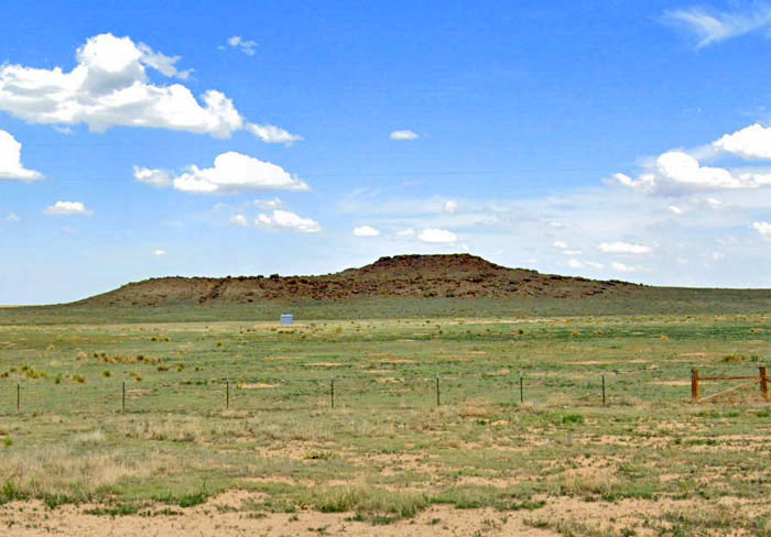
Cimarron County, Oklahoma Landscape by Kathy Alexander.
The smallest portion of the Santa Fe Trail was in Oklahoma. Of the two major trail branches, only the Cimarron Route crossed into the state through the western portion of the Oklahoma panhandle in modern Cimarron County. The Cimarron Route in Oklahoma was only 46 miles long, from the northern border with Colorado to the border with New Mexico. The lesser-used Aubry Cutoff was also partially within Oklahoma. This route started near Fort Aubrey in western Kansas, crossed the Arkansas River at the crossing downstream from the fort, forded the Cimarron River in northern Cimarron County, Oklahoma, and ended near Cold Spring Campground, northwest of modern Boise City.

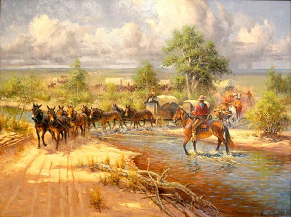
Jornada Del Muerto on the Cimarron Route of the Santa Fe Trail, photo courtesy National Park Service.
The Cimarron Cutoff was used by William Becknell in 1822 when he took the first wagon train to New Mexico. It was destined to carry approximately 75% of the traffic along the trail. The Cimarron Route was shorter and easier to travel with mule and ox-drawn freight wagons, and shortened the traveling time by ten days. However, it was considered much more dangerous than the Mountain Route due to water shortages and the threat of Indian attacks. Warriors prized not only the cargoes of the freight wagons but draft animals and the horses and mules acquired in New Mexico and herded back to Missouri.
Others known to have followed portions of the Santa Fe Trail included numerous scouts, soldiers, trappers, and buffalo hunters. The Trail also served as a trading route for the Kiowa, Ute, Comanche, and Apache tribes.
Depending upon where the trail left the Arkansas River, it was a 50 to 60-mile journey to reach the next reliable water, the Cimarron River. This stretch, called the Jornada, with poor grass and scant water, was a much-dreaded section of the trail. During various times of Indian unrest, the U.S. Army was forced to escort travelers crossing this region.
Upon reaching the Cimarron River, the trail followed the water into present Cimarron County, Oklahoma, crossed the river at Willowbar Crossing, and continued southwesterly to Cold Springs. There, Autograph Rock still displays the names carved by scores of travelers into the ledges at the springs. This permanent water source was considered a significant stopping point where wagons were repaired, and the livestock rested before continuing.
Wagon trains laden with cloth, firearms, metal products, and whiskey frequently formed lines of four to six vehicles abreast. In some places, they cut a 400-foot-wide swath. In 1834, an unusually heavy, prolonged rainfall loosened the soil along the track. Traders’ wagons cut deep, indelible ruts, still visible today, across the present Oklahoma Panhandle.
The Jornada danger was not relieved until 1850, when Francis X. Aubry opened a better watered, although slightly longer, alternate route that left the Arkansas River farther west, near present Syracuse, Kansas. The Aubry Cutoff joined the original Cold Springs trail and continued past Camp Nichols. That short-lived military post, established by Christopher “Kit” Carson in 1865, was the only military establishment on the Santa Fe Trail in Oklahoma. The trail finally exited the state from the southwestern portion of Cimarron County into Union County, New Mexico.
Willow Bar Crossing of the Santa Fe Trail in Cimarron County, Oklahoma, by Wayne Cooper.
Willow Bar Crossing – Willow Bar Crossing was where the Santa Fe Trail crossed the Cimarron River, leaving the valley for higher ground and passing on both sides of Wolf Mountain. About 18 miles northeast of Upper Spring on the south side of the Cimarron River. A popular stopping place for trail travelers, the site was marked by a sandbar covered in willow trees in the riverbed. Willow Bar usually had water and was frequently used as a campsite.
As the Cimarron Cutoff became more widely used, Indian attacks on traders increased. In July 1831, an estimated 100 warriors, possibly Comanche, struck an encamped wagon train at Willow Bar. The raid took place following the noon meal. Most teamsters enjoyed a siesta before resuming the trek down the trail. Shots fired by charging warriors aroused the drowsy wagoners, who managed to return fire. Amid great confusion, some of the men manned a small cannon that was part of the train’s armament. The Indians, however, fled out of range, and the rounds fell short. Neither side suffered any casualties, but similar and more costly hit-and-run skirmishes became commonplace. Located approximately 11 miles north and 11 miles east of Boise City, Oklahoma, no evidence remains of the crossing today, and the river has long since erased the willows and sandbar.
Nearby are trail ruts and a watering hole from the Trail days called Trujillo Springs, but it rarely has water today and often appears more like a dry streambed. Also, here are the old block ruins of the David Trujillo Homestead.
Wolf Mountain in Cimarron County, Oklahoma, courtesy of Google Maps.
Wolf Mountain – Wolf Mountain was a landmark for Santa Fe Trail travelers. It is located between Willow Bar and Upper Spring, nine miles north and a mile and a half west of Boise City, east of US-385 Highway between Willow Bar and Upper Spring. Branches of the trail passed on both sides of this mountain on the way to Upper Spring. Also a popular camping spot, it too was subject to Indian attacks. A marker at the site reads: “About 20 wagons burned here by Ute Indians sometime before trail abandonment in 1880. Erected Sept 1991 by Robert & Albert Kohler.” In later years, numerous artifacts were uncovered, such as burned wagon parts, dozens of iron-rimmed wheels, and broken dishes. It was only by counting the spoked wheels scattered among the charred pieces of wood that the size of the doomed party could be determined.
Upper Flag Spring – Upper or Flag Spring is a beautiful setting, with a high rocky hill, the spring, a pond formed by an earthen dam, and views of the Cimarron Valley. It was a campsite on the Santa Fe Trail with a reliable source of fresh water on the south side of the Cimarron River. At Upper Spring, the trail left the watercourse of the Cimarron River. It was also the scene of Indian troubles. Upper or Flag Spring is nine miles north and one and a half miles west of Boise City.
Cold Spring and Autograph Rock
Cold Springs Creek, a tributary of the Cimarron River, provided much-needed water in the semi-arid plains of the Oklahoma panhandle. Because of the year-round water access and protection provided by high cliffs, Cold Spring Creek became a popular camping place along the Santa Fe Trail. Archeological evidence suggests that the site was used by Native Americans long before the Santa Fe Trail and other travelers. People passing through often carved their names into the sandstone bluffs at the site, which became known as Autograph Rock Signatures. The signatures on the walls, dating mainly from 1850-1865, were left by soldiers, teamsters, gold seekers, and others traveling the Santa Fe Trail. F.B. Delgado, who owned a mule and ox train that freighted the trail, is signed more frequently than any other name at Autograph Rock.
Autograph Rock is approximately seven miles west and seven miles north of Boise City, Oklahoma. The site is privately owned but allows visitors onto their property to view Autograph Rock and the immediate area at certain times between May and September. However, Cold Springs is not accessible. For permission and arrangements to visit the site, contact the Cimarron Heritage Center in Boise City to set up an appointment – 580-544-3479.
Just a few miles northeast is the much smaller Inscription Rock site, which also features an outcrop with carved names and another Cold Spring campsite with a small stone house once used as a stage station. It was also a popular campsite with Trail travelers. Inscription Rock is part of the same property as its larger sister site, but is not open to the public. Both sites are believed to contain unmarked graves.

Autograph Rock, Santa Fe Trail, Oklahoma, by the National Park Service.

Autograph Rock, Santa Fe Trail, Oklahoma, by the National Park Service.
Camp Nichols – Camp Nichols was the only military site on the Santa Fe Trail in Oklahoma. Founded by Colonel Kit Carson, it was occupied for only a few months in 1865. The troops stationed here protected travelers on the Cimarron and Aubry cutoffs. The soldiers built a stone wall around the parade ground and erected some officers’ quarters and other structures. The site, located 3.5 miles northwest of Wheeless, Oklahoma, is private and cannot be accessed. However, wagon ruts can still be seen about a half mile south of the fort site.
Cedar Spring and Carrizozo Creek – Cedar Spring is near the Camp Nichols site, 3.5 miles northwest of Wheeless, Oklahoma. This spring was the water source for Camp Nichols and Santa Fe Trail travelers. Names are carved in the nearby canyon walls of Carrizozo Creek, including members of the Penrose Expedition, who were caught there in a blizzard in 1868. T.O. Boggs, an expedition scout, later founded Boggsville in Colorado.
The trail was used into the 1870s when the railroad was built into Colorado.
Today, the remoteness and empty spaces of the region that were so challenging for Santa Fe caravans make it one of the best places for the modern traveler to capture a sense of what it must have been like to travel the Santa Fe Trail in its heyday.

Camp Nichols, Oklahoma, courtesy of the Oklahoma Historical Society.
©Kathy Alexander/Legends of America, updated November 2025.
Also See:
Santa Fe Trail Detail & Timeline
Sources:
Bad Hoss Map Company
National Park Service
Oklahoma Highways: Indian Trails to Urban Expressways
Oklahoma Historical Society
Oklahoma Senate
Santa Fe National Historic Trail Comprehensive Management Plan, 1990
Santa Fe Trail Association