
Route 66 in Santa Rosa, New Mexico, by Kathy Alexander.
Santa Rosa, New Mexico, is known as the “City of Natural Lakes ” due to its many natural lakes and streams. Situated where the Great Plains rise to meet the Rocky Mountains, this startling oasis is amid the red mesas of the flatlands.
In 1865, the town began as nothing more than a large Spanish Rancho and was called Aqua Negro Chiquita. Around 1890, it took a new name honoring a chapel built by Don Celso Baco, who named it for his wife and Saint Rose of Lima, the first canonized Saint of the “New World.” Guadalupe County was created by the territorial legislature in 1891, with Puerto de Luna as the county seat. Santa Rosa remained a minor community until the Chicago, Rock Island & Pacific Railroad steamed into town in 1901, then became an important transportation hub. Just two years later, Santa Rosa became the Guadalupe County seat.

Early Santa Rosa, New Mexico.
When Route 66 was completed through Santa Rosa in 1930, transportation services again increased in the city. During the days of early Route 66, after travelers had tired of the long, hot, dusty miles, Santa Rosa became known as a welcome and well-known oasis in the desert. Travelers arrived in Santa Rosa to eat, rest, and perform car repairs, if necessary, at the many motels, cafes, and service stations that lined the highway.
The old road ran into town past the 81-foot-deep Blue Hole and Park Lake, a motorist campground and water source during the Depression. Scenes in Rudolfo Anaya’s award-winning novel, Bless Me, and John Steinbeck’s Grapes of Wrath took place on Route 66 at the Pecos River Bridge.
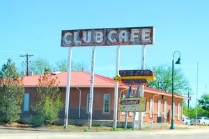
In 1935, Phillip Craig and Floyd Shaw built the Club Café with the smiling, satisfied face of the Fat Man. For over 50 years, thousands of hungry Route 66 travelers would stop to enjoy a tasty home-cooked meal. The Fat Man logo soon became synonymous with Route 66 in Santa Rosa.

Old Club Cafe, Santa Rosa, New Mexico.
In 1940, when Steinbeck’s epic novel Grapes of Wrath was made into a movie, director John Ford used Santa Rosa for the memorable train scene, in which Tom Joad (Henry Fonda) watches a freight train steam over the Pecos River railroad bridge into the sunset.
In 1972, I-40 opened through Santa Rosa, and though the city remained a busy off-ramp, many vintage Route 66 businesses began to die. However, others continued to serve the exiting travelers of I-40, including the Club Café, which survived for almost another 20 years. Finally, it, too, served its last meal in 1991. The Club Cafe stood vacant and soon fell into disrepair with the passing of the years.
Joseph and Christina Campos, who own Joseph’s Bar and Grill down Route 66, purchased the building with plans to reopen the Club Café. Unfortunately, the building was too far gone to reopen, and in October 2015, it was demolished. However, they resurrected the Fat Man, bringing him home to Joseph’s Bar and Grill and saving the famous “Fat Man” icon.
Club Cafe, Santa Rosa, New Mexico, when it still stood empty. The building was demolished in October 2015.
Today, there are plenty of signs of the good ole’ days of Route 66 through Santa Rosa. Look for “billboards” painted on huge roadside boulders and the still-grinning faces of Fat Man billboards before you enter the town. A particularly scenic stretch of Route 66 parallels Interstate 40 and can be accessed from the three exits east of the city. Once you enter Santa Rosa, you can see the Comet Drive-In, Silver Moon, Sun and Sand, and the La Loma Motel. The neon lights will thrill your Route 66 sensibilities if you’re traveling at night. While in Santa Rosa, another “must stop” is the Santa Rosa Auto Museum.
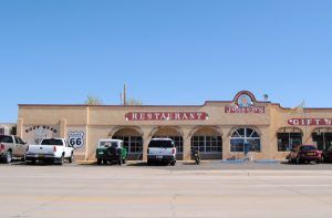
Joseph’s Restaurant in Santa Rosa, New Mexico, by Kathy Alexander
More activities abound at the area lakes, where you can scuba dive at the Blue Hole, fish at natural Perch or Park Lakes, and enjoy all the amenities of a large man-made lake, such as boating, skiing, and camping at Santa Rosa Lake State Park. A side trip well worth the trip is the ancient adobe village of Puerto de Luna, just ten miles south of Santa Rosa.
In the early days of Route 66, the old pre-1937 alignment of Route 66 in New Mexico, sometimes referred to as the Santa Fe Loop, began 18 miles west of Santa Rosa at the junction of I-40 (Route 66) and U.S. Highway 84. The highway then traveled northwest through the ghost town of Dilia before reaching Romeroville, where the path turned southwest, following the old Santa Fe Trail through the Pecos River Valley and onto Santa Fe.
In late 1937, Route 66 was straightened beyond Santa Rosa, making a more direct route to Albuquerque through Cline’s Corners and Moriarty, bypassing Santa Fe completely.
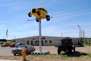
Route 66 Auto Museum in Santa Rosa, New Mexico, by Kathy Alexander.
Here, you will need to choose which alignment you will take westward. Both alignments are a delight as you pass by numerous vintage peeks of the Mother Road, historic places, ghost towns, and beautiful views.
©Kathy Alexander/Legends of America, updated May 2025.
Also See:
Route 66 Pre-1937 Alignment in New Mexico
See Sources.

To Clines Corners or Dilia

