Moriarty

The Crossley Standard Oil Gas Station in Moriarty continues to stand, last known to be utilized as a shoe store.
When traveling Route 66 from Cline’s Corners, New Mexico, your next stop will be Moriarty, home of the Fighting Pintos. Established in 1887, Moriarty was named for Michael Moriarty, one of its original homesteaders. In its early days, most of its residents were dryland farmers. Still dependent upon area farming, today’s more sophisticated farmers utilize large pivotal irrigation rigs to raise alfalfa and feed corn, wheat, pinto beans, pumpkins, and other crops.
The Santa Fe Central depot was completed in 1903, and today, traces of the old railroad bed can still be seen. The metal-sided depot, one of four such structures on the mainline from Santa Fe to Torrance, continues to stand.
Later known as the New Mexico Central Railroad, the line was absorbed by the Santa Fe Railroad in 1926. In 1949, the depot was replaced by a small frame building and a wooden boxcar. The original depot passed through several hands over the years, serving as a feed store, a workshop, and a Catholic Church.
Moriarty became part of Route 66 in 1938 with the highway’s realignment. Like many others along Route 66, the small town rose to the occasion with several motor courts, restaurants, and other services. Many of these continue to stand and operate today.

Whiting Brothers Station, Moriarty, New Mexico.
As you first enter the town, you will see the Sunset Motel and the last operating Whiting Brothers Service Station on the right side of the road. Across the highway is the Sands Motel.
In the southwest, Whiting Brothers gas stations were a familiar sight along Route 66, a tradition that continued until the 1990s when the gas station chain ended. The old Whiting Brothers station in Moriarty is the only one that is left, thanks to Sal Lucero, a lifelong employee of Whiting Brothers. In the 1980s, Lucero bought the station from the Whiting Brothers and never bothered to change the name. Today it continues to stand as a tribute to the heydays of Route 66.
You’ll see the Boot Shoe Shop, which was once home to the old Crossley Service Station, a bit further down. Across the street stands the old Yucca and Cactus Motels, which are long closed, and the Lariat and Ponderosa Motels, which continue to operate to this day. While in Moriarty, be sure to check out the El Comedor Restaurant’s restored “rotosphere.” Consisting of two vertically counter-rotating spiked hemispheres, the entire unit rotates horizontally above a pole. Each of the 8-foot-long rainbow-colored spikes is individually outlined in neon. The rotosphere is believed to be the only operational one of its kind along the entire length of Route 66, thanks to the Route 66 Neon Restoration Project. The project, managed by the New Mexico Route 66 Association, partnering with the New Mexico Historic Preservation Division and the National Park Service Route 66 Corridor Preservation Office, has restored the rotosphere and ten other vintage Route 66 signs across New Mexico. The El Comedor is located at 1005 Route 66.
While in Moriarty, you can also stop at the Moriarty Historical Society Museum, housed in the town’s first fire station. The museum focuses on the growth and development of the town during its early railroad days. Located at 777 Old U.S. Route 66, and admission is free.

Midway Trading Post between Moriarty and Edgewood, New Mexico.
As you leave Moriarty, Route 66 becomes Highway 333 and shares the road with the Salt Missions Trail Scenic Byway to Tijeras. Along this stretch, some original architecture remains, and the spirit of Route 66 is present at the many modern family-operated businesses along the old route. Leaving the flatlands, the byway begins to rise in elevation as you near Edgewood, on the very edge of the mountains, as its name implies. As you leave Moriarty, Route 66 becomes Highway 333 and shares the road with the Salt Missions Trail Scenic Byway to Tijeras. Along this stretch, some original architecture remains and the spirit of Route 66 at the many modern family-operated businesses along the old route. Leaving the flatlands, the byway begins to rise in elevation as you near Edgewood, on the very edge of the mountains, as its name implies.
Edgewood
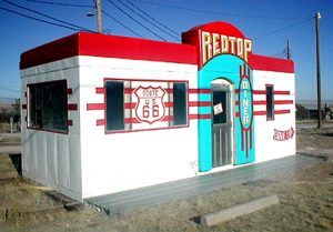
The Red Top Valentine diner in Edgewood, New Mexico, photo courtesy Jerry Ueckert.
Homesteaders moving into the American West created the initial settlements that grew into what is now the town of Edgewood. Founded in the early 1930s, Edgewood is a “young” town by New Mexico standards. Established just in time to meet the needs of the changed 1937 Route 66 alignment, Edgewood exudes the very essence of the Mother Road. All manner of motor courts and other services soon popped up.
Today, due to its proximity to Albuquerque, it is one of the fastest-growing communities in the state. Though its population is about 3,700 people, the area abounds with horse properties, and it’s not unusual to see modern-day cowboys riding their steeds along the roadways.
The original two-room schoolhouse still stands. Travelers might want to visit Wildlife West Nature Park, located at exit 187. Here, you can view numerous native New Mexican animals, including whitetail deer, bobcats, cougars, coyotes, javelinas, raptors, mountain lions, and wolves. Trails through the 122-acre park are constructed through natural habitats.
Also in Edgewood is an old Valentine Diner that once stood in Magdelena, New Mexico, before Jerry Ueckert purchased it and moved it to Edgewood. The diner had extensive damage and has now been fully restored. It is located on Route 66.
Barton
Just about three more miles will bring you to Barton, New Mexico, which is officially a ghost town but not much more than a scattering of buildings that are now considered part of Edgewood. Named for an early resident, Barton received a post office in 1908, but by 1936, it had closed, and area residents received their mail from Edgewood. In 1946, Jack Rittenhouse described the town as having a gas station, a grocery store, and a few cabins. At the corner of old Route 66 and Mountain Valley Road once stood an old Conoco gas station. Though it is gone today, the site is still home to a couple of old gas pumps, a few rusting cars, and the original Barton jail, which once detained such outlaws as the Dawson Gang. From Barton, the highway continues to climb toward Tijeras.
Sedillo

Sedillo Hill, New Mexico.
Route 66 climbs to some 7,000 feet elevation up Sedillo Hill to Sedillo, New Mexico. The town was named for Pedro de Cedillo, who was originally a native of Queretaro, Mexico. Arriving in the area before the Pueblo Revolt of 1680, he served as a captain until he and his family were forced out of the area. His descendants returned to New Mexico after the re-conquest of 1692. In 1819, one of his descendants, Esteban Sedillo, was given land in Tijeras Canyon east of present-day Tijeras. Soon afterward, the Sedillos moved east to the town now named for them. Beyond Sedillo, the route begins to drop down into the valley through Tijeras Canyon.
Tijeras
About 900 years ago, Native American people lived in Tijeras Canyon villages, which were still occupied when the Spanish arrived. Right in the center of the canyon once stood the Tijeras Pueblo. Established in about 1300 A.D., the adobe structure housed about 400 people believed to have been part of an overall migration of inhabitants from the Four Corners region. The structure, encompassing some 200 rooms, was arranged in a large U-shape. By the middle of the 14th century, the people had left, and the pueblo was falling into ruin. Around 1390, another group of Native Americans inhabited the site and rebuilt the pueblo on a smaller scale. They, too, didn’t stay long, as, by 1425, it was permanently abandoned, most likely due to drought in the Rio Grande Valley. Today, all that remains of the old pueblo is a grass-covered mound located directly behind the Sandia Ranger Station. A self-guided tour can be taken any time during daylight hours (stop at the Ranger Station for directions).
“Tijeras,” meaning “scissors” in Spanish, comes from the fact that the pueblo was on the crossroads of two major trade routes, one extending from Mexico City to Santa Fe and the other from the Great Plains to the Pacific Ocean.
After the Pueblo dwellers, Apache Indians used the Canyon as a passage and campground when they rode west to raid communities along the Rio Grande. Later, the Comanche also utilized the canyon as a staging area to discourage settlers in the area.
However, in 1763, the Spanish government provided land ownership incentives to those willing to homestead the area. Hispanic settlers, primarily from Albuquerque, came to the canyon. Still, in 1770, an Apache attack drove the settlers back to Albuquerque, though they often traveled to the canyon for timber and hunting. In the early 1800s, attempts to settle the area were more successful despite sporadic Indian raids that continued into the mid-1860s.
Before the Civil War, the Canyon transported information and military supplies between Albuquerque and Fort Stanton. Both Confederate and Union armies occupied it during the war, but no battles took place in the canyon.
In 1868, more than 6,000 Navajo traveled from Fort Sumner, where they had lived in detention for more than four years, north to Sedillo and then west through the Canyon.
In about 1880, a village called Tijeras was established at the crossing of the Manzano and Sandia mountains. It was initially called home to 15 families who primarily worked at farming and ranching. There were also some small mining activities in the canyon.
Once the area was successfully settled, residents needed a church, which began in a resident’s home in 1870 and was later sold to Mrs. Jessie.
Keleher donated the building for use as the Immaculate Conception Church in 1912 with the stipulation that it be maintained as a church. In 1930, the church building and property were returned to the Keleher family. About five years later, it became a church once again and was renamed Santo Niño (Holy Child). Eventually, the church on the National Register of Historic Places was given to the Village of Tijeras. It is located on the west side of Route 66, just south of the Tijeras Library, and is utilized as a community events center.

Tijeras, New Mexico Church.
When Route 66 was first established in 1926, it didn’t initially pass through the canyon. However, when the Mother Road was shortened and realigned through the area, it followed US 470, which linked Albuquerque with Moriarty. However, the road soon became too crowded and unsafe, especially along a dangerous, blind turn known as “Dead Man’s Curve.” In the early 1950s, the road began to be rebuilt as a four-lane highway and as the most significant road project ever taken on in the State of New Mexico. During the drilling, dynamiting, and dirt-moving, a caravan of about 15 cars full of hired union men showed up to slow down the work. Commonly known as hired “goons,” they protested, “Our men are on strike!” However, the road builders and contractors of New Mexico were not part of the union. Day after day, the goons tried unsuccessfully to delay the work and intimidate the employees for almost two months. Finally, the goons disbanded, and the union never succeeded in “organizing” the road crews and contractors in New Mexico. In 1951, it was finally completed. In 1965, Tijeras Canyon would be bypassed when I-40 was built through the area.
The village of Tijeras, situated within the boundaries of the Cibola National Forest, is the southern gateway to the Turquoise Trail Scenic Byway, which travels to Santa Fe. Along the trail are unique towns, museums, and recreational opportunities where prehistoric peoples once made their homes. In Tijeras, there is one of the Cibola National Forest’s Visitors’ Centers and the Talking Talons Leadership Center & Living Conservation Museum. Today, Tijeras is home to nearly 600 residents and growing.
West of the village, Route 66 emerges from the canyon, where you can see a beautiful view of the Rio Grande Valley and Albuquerque. Through this stretch, keep your eyes open for old trading posts and wayside gas stations, and enjoy the majestic views of the Rio Grande Valley and the Sandia Mountains.
© Kathy Weiser-Alexander/Legends of America, updated March 2025.
Also See:
New Mexico Route 66 Photo Gallery
Sources:
Bernalillo County, New Mexico
New Mexico Historical Society
The Route-66
Wikipedia


