
Georgia Coast.
Georgia’s Coast stretches approximately 100 miles from historic Savannah — Georgia’s oldest city — to St. Marys, the gateway to Cumberland Island National Seashore. This region features dozens of opportunities for every traveler. From isolated beaches, mysterious swamps, and tranquil marshes, to cobblestone streets, historic forts, and lush plantations, to century-old buildings, dozens of which are now home to boutiques and restaurants, there is something here for everyone.
Coastal Georgia has a rich history, from Native Americans to French and Spanish explorers to its status as the southernmost of America’s original 13 colonies. The first documented exploration was carried out along the coastline in 1525 by two ships from Puerto Rico under pilot Pedro de Quejos, who had landed in South Carolina in 1521 on a slaving expedition.
The first European settlement in what would become the 13 colonies was made in Georgia in 1526, when Spanish explorer Lucas Vazquez de Ayllon, who had landed in South Carolina, moved south with his colonists along Indian Trails. The short-lived colony of San Miguel de Gualdape, thought to be near Sapelo Sound, lasted just a few months before it was abandoned in early 1527.
It is believed that the pirate Edward Thatch, better known as Blackbeard, sailed along the Georgia coast, plundering other ships and using Georgia’s meandering rivers, creeks, and inlets as hiding places. It is rumored that Blackbeard buried treasure on a Georgia island that was never recovered.
Take a tour through Georgia’s beautiful and history-rich coast.

Oglethorpe Avenue in Savannah, Georgia, 1900, by the Detroit Photographic Co.
Savannah – The largest city and county seat of Chatham County, Georgia, was established in 1733 and served as the first colonial and state capital of Georgia.
Savannah Historic District – A National Historic Landmark, this district is significant for its distinctive grid plan and 18th and 19th-century architecture. The district encompasses the original town plan laid out in 1733 by General James E. Oglethorpe, founder of the British colony of Georgia. Today, Savannah retains much of this plan based on divisions called wards, squares, and “trustee lots.” Most of the original squares remain surrounded by fine examples of buildings in the Georgian, Greek Revival, and Gothic styles. Notable buildings include the Owens-Thomas House (Oglethorpe Square), built in 1818; the Beaux-Arts style Edmund Molyneux Mansion (Bull Street), circa 1917; the Spencer Woodbridge House (Habersham Street), built in 1795; and the 1853 Gothic Revival Greene House (Madison Square). Important sites associated with the African American community in the district include Beach Institute (East Harris St.), constructed in 1865 as the city’s first black school, and the King-Tisdell Cottage (East Harris St.), the 1896 home of a working-class African American family. The boundaries of the Savannah Historic District are the Savannah River, E. Broad Street, Gwinnett Street, and Martin Luther King, Jr. Boulevard. Self-guided tours of Savannah are available from the Savannah Visitor Center, in the restored Central of Georgia railroad station at 301 Martin Luther King, Jr. Blvd. The visitor center is open Monday through Friday, 8:30 a.m.-5:00 p.m., and Saturday and Sunday, 9:00 a.m.-5:00 p.m. (912) 944-0455.

Victorian district in Savannah, Georgia. Photo by the Historic American Buildings Survey.
Savannah Victorian Historic District – Savannah’s first suburb, this area is located just south of the Savannah Historic District. Originally a parade ground, the extension of street railways in the late 19th century spurred the development of this neighborhood. The wood-frame houses dating from the 1870s and 1880s are a mix of several Victorian architectural styles. Some of the best examples are the Carpenter Box-style houses on West Gwinnett Street, embellished with ornate brackets and cornices; the Queen Anne-style mansion at the corner of Whitaker and Gwinnett; and the imposing Victorian Telfair Hospital on Park Avenue. The boundaries of the Savannah Victorian Historic District are Gwinnett Street, Anderson Street, and building lines just beyond Montgomery Street and Price Street.
Laurel Grove-South Cemetery – This historic cemetery is a significant visual record of Savannah’s African American history. In 1852, fifteen acres of the Laurel Grove Cemetery were set aside for the burial of “free persons of color and slaves.” The cemetery was historically separated from the white Laurel Grove-North Cemetery by what is now Highway 204. Tombstones range from small markers with little or no ornamentation to monumental markers with elaborately carved figures. Inscriptions on many tombstones record African American history not included in the region’s written histories. It is located on 37th Street in Savannah.
First Bryan and First African Baptist Churches – In 1788, Andrew Bryan, a former slave, organized one of the earliest black Baptist churches in North America. Bryan began preaching while a slave in Chatham County. In 1788, he purchased his freedom and formed a congregation that was chartered as First Bryan Baptist Church. This congregation was significantly involved in the affairs of the Savannah black community. In 1793, Bryan obtained the lot where the First Bryan Baptist Church (constructed in 1873) now stands. A dispute over doctrine in 1832 caused a schism, resulting in two congregations. The congregations of the First Bryan Baptist Church and the First African Baptist Church, constructed in 1859, are direct descendants of Bryan’s original congregation. First Bryan is at 575 West Bryan Street, and First African is at 23 Montgomery Street in Savannah.

Fort Pulaski, Georgia, by the National Park Service.
Fort Pulaski National Monument – Built between 1829 and 1847 on Cockspur Island to protect the river approaches to the city of Savannah, Fort Pulaski was part of America’s ambitious Third System of coastal fortifications. The fort was considered impregnable by most military authorities, featuring walls of solid brick seven and one-half feet thick. At the beginning of the Civil War, Confederate forces occupied Fort Pulaski, and early in 1862, Union forces laid siege to it. Using newly developed rifled cannons with superior range and penetrating power, the Federals breached the fort’s walls in a 30-hour bombardment that forced a Confederate surrender. The restored fort is a monument to the power of technology to render previous conceptions of invincibility instantly obsolete. Fort Pulaski National Monument, administered by the National Park Service, is east of Savannah, off U.S. Highway 80. Open daily, 9:00 a.m. to 5:00 p.m. For more information, visit the National Park Service website for Fort Pulaski National Monument or call 912-786-5787.
Wormsloe Plantation – Situated on a forested peninsula surrounded by coastal marshes, Wormsloe Plantation was established in 1737 by Noble Jones, one of the first British colonists in the area. The site includes a plantation house built by Jones’ grandson in 1828, a detached library, the ruins of a fortified house, a mile-long drive bordered by large oaks, and Confederate earthworks. Wormsloe was Noble Jones’s country estate, where he experimented with his grand passion—horticulture. He protected his property’s cypress and oak forests and never cultivated the land. The surviving ruins of the original house are among the few remaining examples of fortified houses once typical throughout coastal Georgia. Wormsloe Plantation State Historic Site is located 10 miles southeast of Savannah at 7601 Skidway Road, just north of Isle of Hope. Open Tuesday-Saturday 9:00 a.m.- 5:00 p.m., Sunday 2:00 p.m.-5:30 p.m. Admission fee, 912-353-3023.
Isle of Hope – Located in Chatham County, Georgia, and part of the Savannah Metropolitan Statistical Area, this community is one of the most affluent in the state. It is well known for its historic plantations and exclusive waterfront properties. Despite its name, this area is not an island. Legends abound of pirates using the island to hide their booty, and generations of children have gone digging for this treasure. Legend also says that French Huguenots used the island as a place of refuge for fleeing persecution. Its population today is about 2,400 people.
Isle of Hope Historic District – Established as a retreat in the 19th century for the elite of Savannah, Isle of Hope provided a refuge from the intense heat and malaria outbreaks prevalent throughout the summer months. Initially owned by Henry Parker, the land was divided into lots in the 1850s and 1860s. These were sold to prominent Savannah families who built stately homes along the water. A small African American settlement in the district dates from after the Civil War, when freed slaves from Wormsloe Plantation settled in the town. In 1871, a railroad was built connecting Savannah with the Isle of Hope, and by the early 20th century, many residents were living in the town year-round. The historic district encompasses a large area extending back from the Skidaway River. Landscaped with old oak trees covered in Spanish moss, the houses range from Greek Revival, Victorian, and Neoclassical to Craftsman Bungalows. Many of the residences also have both formal and informal gardens. Isle of Hope is located 8 miles southeast of Savannah.
Midway – Situated near Savannah, Brunswick, St. Simons Island, and Jekyll Island, Midway’s history dates back to the 18th century, when Puritans migrated to St. John’s Parish, Georgia, from Dorchester, South Carolina, in 1752 and established several settlements, including what later became the Midway community. Wetlands surround the midway, and there are two islands, Colonel’s Island and Dolphin Island. Its population is about 2,100 people.

Midway, Georgia Church & Cemetery.
Midway Historic District – Once an influential center for political, economic, and religious life, the colonial town of Midway was founded by New England Puritans in 1752. These colonists were firmly in favor of independence from Great Britain, and during the Revolution, the British burned the church and most of the town’s buildings. The church was rebuilt in 1792. Also remaining to represent the colonial era of Midway are the historic 1756 cemetery and a segment of the historic “Old Sunbury Road,” now a portion of Georgia Highway 38. A museum modeled after the houses that once stood in Midway is also located in the district. The Midway Historic District is at the junction of U.S. Highway 17 and Georgia Highway 38. The museum is open Tuesday-Saturday, 10:00 am. – 4:00 p.m., Sunday 2:00 p.m. – 4:00 p.m. Closed holidays. Admission fee, (912) 884-5837.
Fort Morris – This fortress is one of the few remaining Revolutionary War-era earthwork fortifications in the United States. First fortified in the 1750s, the fort was manned to protect the once-prosperous seaport town of Sunbury. Fort Morris surrendered to the British on January 9, 1779, the last patriot post to fall in the American Revolution. The Fort Morris State Historic Site is off 1-95 (exit #76). The park and museum are open Tuesday-Saturday 9:00 a.m. -5:00 p.m., Sunday, 2:00 p.m.- 5:00 p.m. Admission fee. (912) 884-5999.
Darien – Situated on Georgia’s coast at the mouth of the Altamaha River about 50 miles south of Savannah, the town of Darien, known initially as New Inverness, was founded in January 1736 by Scottish Highlanders recruited by James Oglethorpe to act as settler-soldiers protecting the frontiers of Georgia from the Spanish in Florida, the French in the Alabama basin and their Indian allies. The second-oldest planned city in Georgia, it is the county seat of McIntosh County and is home to more than 1,800 people.
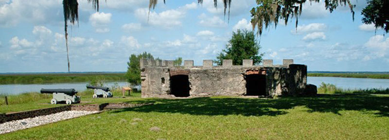
Fort King George – Fort King George, Georgia’s first colonial British garrison, is located at the mouth of the Altamaha River and contains the brick ruins of its early sawmill operation and a small graveyard. Established in 1721 to stop French and Spanish expansion, the fort was the southernmost outpost of the British Empire in North America. The fort was destroyed by fire in 1726 and rebuilt the following year. The surviving portions of the first sawmill are significant and rare examples of early colonial industry in Georgia. A museum interprets the area’s history, including the site’s early occupation by the Guale Indians. The site also includes a reconstructed blockhouse. Fort King George State Historic Site is south of Darien, on U.S. Highway 17, three miles east of 1-95 (exit 10). Open Tuesday-Saturday 9:00 a.m. – 5:00 p.m., Sunday 2:00 p.m. – 5:30 p.m. Admission. (912) 437-4770.
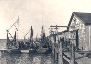
Shrimp boats in Brunswick, Georgia.
Brunswick – Located on the southeastern coastline of Georgia, Brunswick is the county seat of Glynn County. British colonists settled the peninsula in 1738 as a buffer to Spanish Florida. It came under provincial control in 1771 and was founded as Brunswick after the German duchy of Brunswick–Lüneburg, the ancestral home of the House of Hanover. Throughout its history, Brunswick has served as an important port city. Though the town’s population is about 15,640, it is part of a larger urban area that supports more than 100,000 people.
Hofwyl-Broadfield Plantation – Located in the marshlands of the Altamaha River, this plantation illustrates more than a century of Georgia’s coastal history and was owned and occupied by the same family from 1804 to 1973. The plantation, initially known as “Broadfield,” became a center of rice cultivation in the 19th century. The plantation house, “Hofwyl House,” was probably constructed by slave labor in the 1850s after the original residence was destroyed. Modeled after a large farmhouse with the original kitchen and a cabin connected to the house by long passages, the interior shows strong Federal influences. One of the house’s more notable features is the ornate marble fireplace in the dining room. The furniture in the house spans several centuries and includes many rare pieces. The plantation grounds are landscaped with large oak trees, most of which are very old. Tabby ruins, likely the foundation of the rice mill, and several surviving outbuildings, including a barn and an ice house, are located on the property. A museum interprets a working rice plantation and the life of slaves and planters.
The Hofwyl-Broadfield Plantation, a Georgia State Historic Site, is between Brunswick and Darien on U.S. Highway 17, one mile east of 1-95 (exit 42). Self-guided tours are available. Open Tuesday-Saturday 9:00 a.m. – 5:00 p.m., Sunday 2:00 p.m. – 5:30 p.m. Admission. (912) 264-7333.
Brunswick Old Town Historic District – This district encompasses the site of the British colonial town of Brunswick. Named after the family of King George III of England, it is one of two deepwater ports on the coast of Georgia. The town was laid out in 1771 and retained its original plan known as “Old Town,” a grid plan similar to that of Savannah, Georgia’s other deepwater port. Brunswick contains an outstanding collection of late 19th-century residential and public buildings. The best examples are the Hazelhurst-Taylor House (Hanover Square), the Mahoney-McGarvey House (Reynolds Street), and the Old City Hall. The town also retains many of its original sidewalks paved with unusual hexagonal stone tiles. The Brunswick Old Town Historic District is bounded by 1st, Bay, New Bay, “H”, and Cochran Streets. Brunswick is west of Jekyll Island at the junction of 1-95 and U.S. 82.
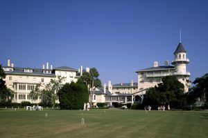
Jekyll Island Clubhouse, Georgia
Jekyll Island – Located in Glynn County, Jekyll Island is one of the Sea Islands and one of the Golden Isles of Georgia. The city of Brunswick, Georgia, the Marshes of Glynn, and several other islands, including the larger St. Simons Island, are nearby. Explorers from Spain were the first to make an official claim to Jekyll Island in 1510, giving it the name Isla De Ballenas (Whale Island). Later, Juan Ponce de León served as the civil governor of this and Spain’s other claimed North American territories. In 1562, French explorer Jean Ribault claimed the island for France and renamed it the Île de la Somme. Ribault later surrendered to the Spanish and was executed, an event that began a conflict between the two countries along the Florida coasts. After his army swiftly defeated the French, Philip II of Spain established a colony in the Jekyll region. Today, Jekyll Island is one of only four Georgia barrier islands that feature a paved causeway to access the island by car. It features eight miles of wide, flat beaches on its east shore with sand packed hard enough for easy walking or biking. About 800 people call the island home.
Jekyll Island Historic District – A National Historic Landmark administered by the state of Georgia, is situated on the southeast side of Jekyll Island. Occupied by the Guale Indians, who called the area Ospo, the island was a popular hunting and fishing site. General James Edward Oglethorpe, the founder of Georgia, maintained an outpost on the island, and one of his officers, Major William Horton, established a plantation. In 1794, a French family, the du Bignons, bought the island. They retained possession until 1886, when the island was sold to the newly formed “Jekyll Island Club.” Considered the most exclusive social club in the United States, the Jekyll Island Club had a membership limit of 100, among them the Astors, Vanderbilts, Pulitzers, Morgans, and McCormicks, and was laid out by prominent landscape architect H.W.S. Cleveland. A clubhouse was built on the island, and members constructed private “cottages”– enormous residences designed to house entire families with staff. The club was open for the post-Christmas season when many families came down from Newport and New York to relax and enjoy the “country life.” In 1942, the U.S. government ordered the area evacuated. The state of Georgia purchased the island from the club in 1947 and turned it into a state park. Most of the cottages have been preserved and are open to the public. Among them are San Souci, owned in part by J.P. Morgan and one of the first condominiums in the U.S.; Indian Mound, the 25-room home of the Rockefeller family; the Goodyear Cottage completed in 1906 from designs by the firm of Carrére and Hastings; Crane Cottage, circa 1917, the largest and most lavish of the cottages; the original Club House, a wood and brick Victorian structure with towers and manicured lawns; and Faith Chapel, built in 1904 in the Gothic style with copies of the Notre Dame de Paris gargoyles. The chapel also has a large, signed Tiffany stained-glass window. The historic district is between Riverview Drive and Old Village Boulevard on Jekyll Island. The Club House is now a fully restored hotel open to the public. The island can be reached off U.S. 17 and Jekyll Island Road, southeast of Brunswick.

St. Simons Island Light, Georgia.
St. Simons – Located on St. Simons Island in Glynn County, Georgia, the community and the island are often considered one location, known simply as “St. Simons Island” or locally as “The Island.” St. Simons Island is one of Georgia’s renowned Golden Isles (along with Sea Island, Jekyll Island, and privately owned Little St. Simons Island). It is also the largest of the Golden Isles. The Island was the northern boundary of the tribal and Spanish mission province known as Mocama, which extended southward to the St. Johns River in present-day Florida. Later, the island was cultivated by English colonists for rice and cotton plantations, which were worked by large populations of African slaves, who created the unique Gullah culture. Since the early 20th century, the island has been developed as a resort community. Today it has a population of about 14,500 people.
Hamilton Plantation – Located on St. Simons Island, the remains of this antebellum plantation contain two surviving slave cabins, originally a set of four built before 1833. Among the better-surviving slave cabins in the South, they are made of tabby, a cement consisting of lime, water, and crushed oyster shells. The cabins have built-in windows and a central chimney. James Hamilton Couper, the namesake of the plantation’s owner and manager, was an architect and builder. He designed and built the cabins to house the slaves who served in the plantation’s main house. Utilizing a duplex plan to house more than one family, the cabins were originally part of a planned community of slave dwellings.
The Hamilton Plantation site and slave cabins are on Arthur J. Moore Drive on the west side of St. Simons Island, 12 miles east of Brunswick. The island can be reached by traveling on U.S. Highway 17 and the Brunswick-St. Simons Causeway.
Fort Frederica, Florida Magazine by the National Park Service.
Fort Frederica National Monument – Administered by the National Park Service, Fort Frederica is located on St. Simon’s Island and interprets the struggle between Great Britain and Spain to dominate the New World. Fort Frederica was the focus of defense for the fledgling English colony of Georgia. The remains of the fortified settlement, established in 1736 by the founder of Georgia, General James Edward Oglethorpe, include ruins of the fort, barracks, walls, moat, and several houses. The fort was established when Great Britain, France, and Spain claimed the area. In 1742, a British victory over the Spanish at the Battle of Bloody Marsh secured Britain’s hold on Georgia. The battle site is six miles south of Fort Frederica. The fort and town fell into decline after Oglethorpe’s regiment was disbanded in 1749, and a 1758 fire destroyed most of the buildings. Fort Frederica is on St. Simon’s Island, 12 miles from Brunswick. It can be reached by traveling on U.S. 17 and the Brunswick-St. Simons Causeway. A visitor’s center, just east of the townsite, is open daily 9:00 a.m. – 5:00 p.m. (912) 638-3639. Admission. 912-638-3639.
St. Marys – St. Marys, one of Georgia’s oldest towns, is in the state’s southeast corner, nine miles from the Atlantic Ocean. Historic St. Marys, Georgia, offers picturesque streets lined with centuries-old live oaks and the restorative beauty of waterways and marshes. The city was once called home to pirates, smugglers, and a robust shipping industry. The St. Marys area was first explored in the mid-16th century as part of the settlement of Spanish Florida, when nearby St. Augustine, Florida, served as the established capital. Settlement for Georgians became legal after the Treaty of Paris in 1763. The town of St. Mary’s was officially established on November 20, 1787, and was made a United States port of entry on March 2, 1799. After the Act Prohibiting Importation of Slaves took effect in 1808, St. Mary’s became, along with Spanish Amelia Island, a center for smuggling, especially between 1812 and 1819 when various rebel groups held Amelia Island. During the War of 1812, the Battle of Fort Peter occurred nearby along the St. Marys River. The British captured the fort and the town, occupying it for about a month. The United States Navy bombarded the town’s shore-side buildings during the Civil War. In 2012, this quaint seaside city had a population of 17,606.
St. Mary’s Historic District – The historic district encompasses the original grid plan of the town, laid out in 1788. During the late 18th century, St. Mary’s was a bustling seaport. Historic sites in the district include the “Washington Oak,” the only remaining tree of four oaks planted in 1799 on the day George Washington was buried, and the 1808 Presbyterian Church, famous for its historic bell, which Paul and Joseph Warren Revere cast. The St. Mary’s Historic District is roughly bounded by Waterfront Road, Norris, Alexander, and the Oak Grove Cemetery. For more information, contact the Orange Hall Welcome Center at Osborne and Conyers Streets. (912) 882-4000 or l-800-868-8687.
Historic Churches – St. Mary’s is prolific in historic churches of virtually all denominations. Rich in history, see the Christ Church Historic Episcopal Chapel, whose original chapel was burned during the Civil War, located at 305 Wheeler St.; the First Presbyterian Church, Georgia’s oldest church in continuous use, at 100 Conyers St.; Our Lady Star of the Sea Historic Catholic Chapel – the oldest masonry building in Georgia at 201 Osborne St.; and St. Marys United Methodist Historic Chapel, which was occupied during the Civil War by Union soldiers, located at 105 E. Conyers St.
McIntosh Sugar Mill Tabby Ruins – Tabby, a building material unique to the area, is made of oyster shells, sand, and water. The mill was built in 1826 and is the largest and best-preserved tabby structure in the Southeast. Its rooms, devoted to the grinding, boiling, and processing of cane for sugar products, are still intact. The building burned in the mid-1800s and was never rebuilt. The ruins are one of the oldest industrial sites in Georgia. Located off of Charlie Smith Sr. Hwy, just left of Kings Bay Road and the Stimpson Gate of Naval Submarine Base Kings Bay, 3600 Charlie Smith Sr. Hwy, 912-729-5600.
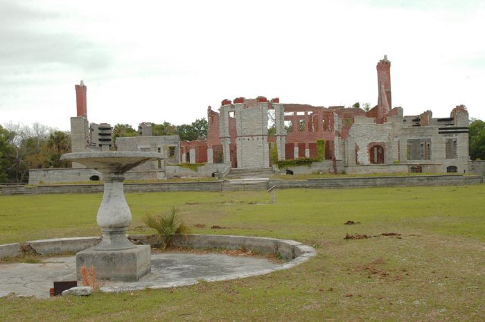
The ruins of the Carnegie Dungeness Mansion, Cumberland Island, Georgia, by the National Park Service
Cumberland Island – St Mary’s is the gateway to Cumberland Island, Georgia’s most significant and southernmost barrier island. Here, pristine maritime forests, undeveloped beaches, and expansive marshes whisper the stories of both man and nature. Natives, missionaries, enslaved African Americans, and Wealthy Industrialists walked here. Cumberland Island is one of the largest undeveloped barrier islands along the Atlantic coast. The island has one of the most extensive maritime forests remaining in the United States and one of the largest wilderness areas in a National Seashore on the East Coast. Located seven miles east of St. Marys, Cumberland Island is only accessible by boat. A concession-operated passenger-only ferry departs from downtown St. Marys. Reservations are strongly encouraged, and passengers must be present 30 minutes before departure. Admission fee, ferry fee, and additional fees for camping and interpretive programs.
The Dungeness Historic District encompasses historical resources from several periods, including a prehistoric shell midden on which later mansions were constructed; a wharf thought to be the site of the early Spanish mission of San Pedro, a historic cemetery, an early 19th-century house constructed of tabby, a cement made of lime, water, and crushed oyster shells, and the ruins of Dungeness Mansion, constructed on the site of the earlier Miner residence.
The Stafford Plantation Historic District includes the 1901 Stafford House, built for William Coleman Carnegie near the site of the Stafford plantation cemetery.
Plum Orchard Historic District includes a small cemetery, the ruins of an early 19th-century plantation home, and Plum Orchard Mansion, built in 1898 for George Lauder Carnegie and designed by Boston architects Peabody and Stearns.
The High Point-Half Moon Bluff Historic District is associated with the African American experience, from slaves to freedmen to property owners, and the development of the Island as a resort area after the Civil War. The district comprises two complexes of buildings located at the northern end of Cumberland Island. Half Moon Bluff is a small village of simple wood-frame buildings. Former slaves settled on Half Moon Bluff from plantations on Cumberland Island. As the land was divided over the years, African Americans continued to purchase parcels. Constructed in 1937, the First African Baptist Church of Cumberland Island is significant as a center of religious and educational life for the community.
The High Point District was initially developed as a hotel and resort complex in 1880. Located in the district is a historic hotel and accompanying outbuildings. The two areas have been historically linked by economic need — the village of Half Moon Bluff provided labor to the hotel complex at High Point.

Steamboats in the Savannah River, Georgia.
©Kathy Alexander/Legends of America, updated November 2025.
Also See:
Cumberland Island National Seashore
Haunted Historic Sites in Savannah, Georgia You Must Visit
Sources: