
Old Oregon Territory by the National Park Service.
The Territory of Oregon was an organized incorporated territory of the United States that existed from August 14, 1848, until February 14, 1859, when the southwestern portion of the territory was admitted to the Union as the State of Oregon.
The fate of the Oregon Territory, along with territorial disputes over the Southwest with Spain and Mexico, was one of the major diplomatic issues in the first half of the 19th century.

Lewis and Clark Trail by the Bureau of Land Management.
Initially inhabited by Native Americans, the region that later became part of the Oregon Territory was first explored by Europeans via the sea. The first documented exploration voyage occurred in 1777, led by the Spanish, followed shortly by British and American vessels. Subsequently, land-based explorations were conducted by Alexander Mackenzie and the Lewis and Clark Expedition. The coastal areas north of the Columbia River were frequented by ships from various nations involved in the maritime fur trade, with many vessels from Boston, Massachusetts, arriving between the 1790s and 1810s.
Oregon Country was a large region in the Pacific Northwest of North America, which became the subject of a long-standing dispute between the United Kingdom and the United States in the early 19th century. British and French Canadian fur traders had entered Oregon Country prior to 1810, before American settlers began arriving in significant numbers from the mid-1830s onwards. This influx of settlers eventually led to the establishment of the Provisional Government of Oregon.
Initially, Spain, Great Britain, Russia, and the United States claimed the territory.
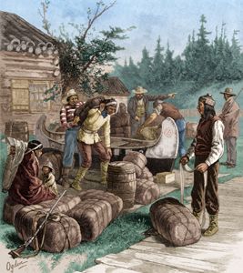
Hudson Bay Company traders by Henry Alexander Ogden.
The Hudson’s Bay Company, whose Columbia Department comprised most of the Oregon Country and extended north into New Caledonia and beyond, managed and represented British interests in the region.
As early as 1818, British and American Commissioners had established the border between the United States and Canada at the 49th parallel, running from the Lake of the Woods (in Minnesota Territory) west to the Rocky Mountains, down to the Pacific Ocean, and east to the Continental Divide.
Indian traders, nevertheless, played a critical role in the ongoing fur trade, which remained the Oregon Country’s primary economic activity until the mid-19th century. The Chinook language, spoken by the Chinook people located on the lower Columbia River, served as a common language between Native Americans and the small European population from 1818 to 1846.
The United States had proposed to extend the border along the same parallel to the Pacific Ocean. Still, Great Britain insisted that the northern border be drawn west to the Columbia River and then follow that river to the ocean.
In 1819, under the terms of the Transcontinental Treaty, Spain ceded its claims to the territory to the United States. Shortly thereafter, the United States contested a unilateral Russian move to grant its citizens a fishing, whaling, and commercial monopoly from the Bering Straits to the 51st parallel.
In 1823, President James Monroe promulgated his doctrine, which put Russia on notice that the United States did not accept Russian attempts at monopoly. The U.S. claim was based on the explorations of Lewis and Clark and on the establishment of trading posts set up by John Jacob Astor’s Pacific Fur Company, such as Astoria at the mouth of the Columbia River. Great Britain based its claim, in part, on James Cook’s exploration of the Columbia River.
The territory became a focus of those who believed that it was the United States’ obligation and right to extend its rule and liberties across the North American continent. The Oregon Territory stretched from the Pacific coast to the Rocky Mountains, encompassing the area including present-day Oregon, Washington, and most of British Columbia.
In 1827, British and American Commissioners agreed to postpone the ownership issue indefinitely, subject to one year’s notice by either party. The matter remained under this agreement until the Webster-Ashburton Treaty of 1842 partially delineated the northeastern U.S.-Canada border, but left the border of the Oregon Territory unsettled.

Reproduction of a vintage Oregon Trail Poster Map. Available at Legends’ General Store
By 1843, the increased American immigration along the Oregon Trail to the Territory Had made the border issue a pressing one in Congress.
After the dispute became an election issue in the 1844 U.S. presidential election, the United Kingdom and the United States agreed to settle the problem with the Oregon Treaty in 1846. President James Polk, a supporter of Manifest Destiny with an eye also on the Mexican Southwest and California, was eager to settle the boundary of the Oregon Territory and proposed a settlement on the 49th parallel (except Vancouver Island) to Great Britain. The Senate ratified the treaty on June 18, 1846.
The area that made up Oregon Country now lies within the present-day borders of the Canadian province of British Columbia and the entirety of the U.S. states of Oregon, Washington, and Idaho, as well as parts of Montana and Wyoming. The capital of the territory was first Oregon City, then Salem, followed briefly by Corvallis, then back to Salem, which became the state capital upon Oregon’s admission to the Union.
Throughout this period, the Oregon Country was inhabited by numerous independent American Indian peoples, who received no recognition by the British or American governments in the eventual disposition of the territory.
The eventual partition of the Oregon Country into national domains by the two colonial powers, increasing settlement, and the drastic decline of the fur trade due to diminishing supply all contributed to a catastrophic decline in the Indian population after 1846, and the arbitrary seizure of their land over the following two decades in the interests of newly arrived settlers.
On February 14, 1859, the territory entered the Union as the U.S. state of Oregon within its current boundaries. The remaining eastern portion of the territory (the portions in present-day southern Idaho and western Wyoming) was added to the Washington Territory.

Columbia River, Oregon.
Oregon Country’s Indian nations retained a sizable majority in their land prior to the rapid and devastating arrival of European diseases in the 1860s. They were able to maintain relative economic independence due to the necessity of their hunting skills in the fur trade.
©Kathy Alexander/Legends of America, October 2025.
Also See:
Sources:
Office of the Historian
Wikipedia – Oregon Country
Wikipedia – Oregon Territory