
Missouri Santa Fe Trail Map courtesy National Park Service.
The National Park Service has identified several high-potential sites along the Santa Fe National Historic Trail. It identifies which sites are listed on the National Register of Historic Places (NR) or have been designated National Historic Landmarks (NHL).

William Becknell blazes the Santa Fe Trail.
Franklin Site – The site of Franklin is north of the Missouri River and about a half mile west of the Boonville bridge on Missouri Highway 87. Franklin was where William Becknell and his party started for Santa Fe, New Mexico, in 1821, following parts of the Osage Trace. They returned with substantial profits, signaling the opening of the Santa Fe Trail. The Missouri River washed away Franklin in 1826-27. The historic site is north of the present river channel.
Boone’s Lick – Boone’s Lick is a Missouri state historic site north of Petersburg. The salt lick or natural saltwater spring was the primary salt producer for settlements along the Missouri River from 1805 until the 1830s. Nathan and Daniel Morgan Boone, sons of Daniel Boone, developed this economic resource. William Becknell was associated with salt production and owned some land in the area. At Franklin, the Santa Fe Trail began as an extension of the Boonslick Road, although the route had been used before 1821 as the Osage Trace, a route from Franklin to Fort Osage. (NR)

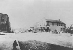
Arrow Rock, Missouri by Kathy Alexander.
Arrow Rock – Arrow Rock is the name of a bluff on the west side of the Missouri River that was used as a landmark. The Lewis and Clark Expedition passed by here in 1804. In about 1811, a ferry across the river was established, leading from Boonslick Road to what was originally the Osage Trace to Fort Osage, the route later followed by the Santa Fe Trail. The town of Arrow Rock, formed in 1829, was a significant site on the Santa Fe Trail. (NHL) (NR)
Arrow Rock Landing – Arrow Rock Landing, located near Arrow Rock, was in use from around 1811 until 1927. Ruts of the road from the landing to the community of Arrow Rock may still be identified. (NHL) (NR)
Santa Fe Spring – Santa Fe Spring is at Arrow Rock, Missouri. It is also known as Big Spring, a place early traders, including William Becknell, used as a point of departure on the trail. (NHL) (NR)

Huston Tavern in Arrow Rock, Missouri, by Kathy Alexander.
Huston Tavern – Huston Tavern is in Arrow Rock. The tavern, which is on the south side of Main Street in the center of town, was built about 1834 by Joseph Huston. It is known to have been visited by many who traveled the Santa Fe Trail. (NHL)
Neff Tavern Site – Located northwest of Arrow Rock, the Neff Tavern site is where Isaac Neff built a log tavern on the Santa Fe Trail in 1837. The trail went between the tavern and the barn (later a stage station), skirted the family cemetery, and continued to the northwest. The tavern was torn down in 1890. The only remaining original structure is the stone smokehouse at the left rear of the brick residence. (NR)
Harvey Spring/Weinrich Ruts – A fine set of five deep ruts is south of Saline County Road 416. The location is five miles northwest of Marshall.
Grand Pass – A landmark on the Osage Trace, the Grand Pass begins about three miles west of Malta Bend. It is a terrace between the Salt Fork and the Missouri River bottoms, followed by U.S. Highway 65. At the east edge of the village of Grand Pass is the community cemetery, which contains excellent ruts of the Santa Fe Trail.

Today, Tabo Creek, Missouri, courtesy of the Missouri Department of Natural Resources.
Tabo Creek Crossing – The Tabo Creek Crossing is south of the Missouri River, eight miles east of Lexington, Missouri, and within sight of U.S. Highway 24. As a major tributary on the south bank of the Missouri River, Tabo Creek presented an obstacle to travelers on both the Osage Trace and Santa Fe Trail routes. In 1821, a license was issued to operate a ferry across the creek. A Daughters of the American Revolution marker, now in Lexington, formerly stood on the creek bank here.
Lexington – The Santa Fe Trail entered Lexington on U.S. Highway 24 and followed Missouri Highway 224 west along South Street. It passed the site of “Old Town,” where the first courthouse stood, and continued to Twentieth Street, turning left and past the Machpelah Cemetery toward the present U.S. 24 junction. It followed the Osage Trace into Jackson County. Later, a branch of the trail went west toward the Missouri River in the vicinity of Jack’s Ferry south of the present highway bridge over the river. On Water Street stood a variety of warehouses and other establishments that served the trait. James and Robert Aull outfitted trading caravans from Lexington, and Robert is buried in the Machpelah Cemetery.

Fort Osage, Sibley, Missouri by Kathy Alexander.
Fort Osage – Fart Osage was at the north city limits of Sibley, Missouri, 14 miles northeast of Independence. It was built in 1808 to fulfill one of the provisions of a treaty between the Osage Indians and the United States. The fort was the westernmost fur trading factory of the U.S. factory system and, due to the efforts of factor George Champlin Sibley, the only profitable one. Fort Osage was also, for a time, the westernmost U.S. military post. According to the treaty’s terms, the fort was a trade center for the Osage, Kanza, and other regional tribes. It was also a convenient rendezvous for trappers, mountain men, and explorers. The official U.S. government survey of the Santa Fe Trail in 1825-27, which Sibley headed, began 1.75 miles south of Fort Osage, where the Osage Trace crossed the eastern boundary of Indian lands as defined by the 1808 treaty. Fort Osage lasted for a few years as the embarkation point for westward travel on the Santa Fe Trail, but Independence soon succeeded it. Today, the fort has been partially restored as a Jackson County park. (NHL)
Little Blue River Crossing – This crossing of the Little Blue River, near the north end of Lentz Road, is at the site where the Blue Mills were located. Until bridged in 1837, it was a difficult river crossing for Santa Fe Trail travelers.
Blue Mills – The site of two Blue Mills is at the north end of Lentz Road in Jackson County. Remnants of the 1834 steam-powered gristmill remain, but there is nothing of the 1835 steam-powered sawmill. The Santa Fe Trail ran between the two mills. The Little Blue River was crossed by a bridge in 1834. The mills were owned by Michael Rice, Samuel C. Owens, and James and Robert Aull, all merchants and traders on the Santa Fe Trail.
Lower Independence (Blue Mills) Landing – The Lower Independence Landing is on the right bank of the Missouri River, about one mile north of the current intersection of Whitney and Courtney roads and 5.5 miles northeast of Independence. This steamboat landing (and an earlier ferry operation) was used from about 1832 into the 1860s, and countless tons of trade goods bound for Santa Fe went up to Independence from this landing. The Santa Fe Railroad tracks cover the site today, and no traces remain of the original landing or ferry.

Upper Independence, Missouri Landing by the National Park Service.
Parties of emigrants, with their tents and wagons, were encamped in open spots near the bank… One or two French hunters from the mountains, with their long hair and buckskin dresses, were looking at the boat.
— Francis Parkman, 1846
Upper Independence (Wayne City) Landing – Serving as a supply port for early pioneers, this steamboat landing and an earlier ferry operation were never as successful or used as long as the Lower Independence Landing, two miles downriver. Located on the south bank of the Missouri River, it was about 3.25 miles north of Independence.

Independence, Missouri Courthouse by Kathy Alexander.
Jackson County Courthouse – The square in Independence has had a brick courthouse since 1829. The present courthouse dates from a 1933 remodeling and expansion overseen by Administrative Judge Harry S Truman. It contains elements of the red brick 1836 courthouse and parts of six later remodelings and expansions. Some of the deeds recorded here mention trials, and some of the magistrate and circuit court cases beard here involved traders’’ and merchants’’ delinquent debts and broken contracts. Trading caravans forming to leave Independence for Santa Fe would sometimes nearly encircle the courthouse on the square’s four streets before heading south on Liberty Street. (NR)
Jackson County Log Courthouse – Located at 107 West Kansas in Independence, this structure was built in 1827 as temporary quarters for the Jackson County government. Deeds to a commercial property on the square were issued and filed here. Merchants’ and ferry operators’ licenses for the early traders and businessmen in Independence and Jackson County were issued here. Independence merchant and Santa Fe trader Samuel C. Owens was a county clerk who handled some of these deeds and licenses; Samuel D. Lucas, another merchant and Santa Fe trader, was his deputy. The log courthouse was moved from its original site to its current location in 1916. The building was altered during the 1920s to its present appearance.
Kritser House – The Martin O. Kritser house at 115 West Walnut in Independence was built in 1847. Kritser made at least one trip to Santa Fe three years before he built this residence. It is typical of the average middle-class home in Independence during its heyday as the eastern terminus of the Santa Fe Trail. (NR)

Old jail building in Independence, Kansas, by Kathy Alexander.
Jackson County Jail – Located at 217 North Main in Independence, the jail was built in 1859 and served as the center for county law enforcement in the waning days of the Santa Fe trade in Independence. (NR)
Lewis-Webb House – The Lewis-Webb home, at 302 North Mill in Independence, was built in 1834, with an addition in 1853. John Lewis, the builder, was a saddler and Santa Fe freighter. (NR)
Ferril-Henky House – The William Ferril-Alanzo F. Henley house is at 3940 South Crysler in Independence and was built about 1830 by Ferril, who may be related to Henry Ferril, who traveled to Santa Fe on Becknell’ss second trip. After a series of owners, Henley bought the house in 1856. Henley and his wife’s family, the Gentrys, were active in the Santa Fe trade.

Nosland House, Independence, Missouri, courtesy Google Maps.
Noland House – Located at 1024 South Forest in Independence, the small, two-room back section was built in 1831, and the large two-story brick front section was built about 1850 for Smallwood Noland. Noland was the proprietor of the Washington House, a well-known hostelry on the square frequented by Santa Fe traders and travelers.
205 North Main – This commercial structure is possibly one of the oldest intact commercial buildings in the Independence Square area. Until the building was remodeled, there was a corbeled gable at the rear and one at the front. Corbeled, or stepped, gables were typical of early construction; examples of similar structures can be seen on the 1866 Bird’s Eye View of Independence, owned by the Jackson County Historical Society.
207-209 North Main – This commercial building was built about 1850 and was remodeled in about 1920. Most of the building is probably the same structure housing the 1850 Kenton House Hotel. The first story has been extensively remodeled; the second story, however, remains intact.
206-208 North Main – Like the Independence courthouse, this building is a good example of the evolutionary nature of buildings on Independence Square. Portions of Smallwood Noland’s 1846 hotel can be seen from the back courtyard. The building has suffered numerous fires and has been rebuilt but never completely torn down. Although various lacunae make interpretation difficult, the structure
remains important to the history of the square.
Woodlawn Cemetery– The cemetery is on Noland Road in Independence. Robert Rickman first patented it in 1837, and the site was used as a county and city burial ground before 1845.
The present cemetery complex consists of the original city cemetery, the Stayton family cemetery, St. Mary’s cemetery, a segregated black cemetery, and a potter’s field. Dozens of people were
important to the Santa Fe Trail story are buried here, including Hiram Young, Samuel and Robert Weston, freighter John Lewis, hotel proprietor Smallwood Noland, Mexican-American War veteran John T. Hughes, merchants William and Jahn McCoy, and attorneys William Chrisman and Samuel Woodson.
Jabez Smith Overseer’s House – Located in Independence on North Broadway, this house was attached to the farm operation of Jabez Smith, a slave speculator and farmer in the 1850s who also had connections to the Santa Fe trade.

Jones House in Independence, Missouri, courtesy of Google Maps.
Lewis Jones House – This house is at the northwest corner of Main and Elizabeth Streets in Independence. The land was purchased by Jones in 1836. Jones was a wagonmaker and owner of the 1849 Nebraska House Hotel in Independence. Jones was an unusually successful businessman as a Santa Fe trader, merchant, and financial backer for other Santa Fe merchants and traders.
Santa Fe Trail Park Ruts – The trail is visible as a swale at the creek crossing in this Independence city park near Santa Fe Road and 29th Street.
Santa Fe Trail Ruts – 31st Street and Santa Fe Road. Ruts of the Santa Fe Trail in Independence are visible about 450 feet south of 31st Street and about 500 feet east of Santa Fe Road (on the west side of Santa Fe Terrace). Near 3126 Santa Fe Road, on the east side of the road, is a visible Santa Fe Trail ramp down part of a high creek bank.
Lewis-Bingham-Waggoner House – Located at 313 West Pacific in Independence, this 19-acre tract is along the route of the Santa Fe Trail as it left the square area. Osage Street, which borders the tract on the east, was part of the trail alignment before 1835. The trail’s width has not changed since then; a road cut on the southeast corner of the property where Osage turns into Linden Street also dates from that period. Lewis built part of the house. George Caleb Bingham, Missouri’s genre artist, and his wife owned the property for six years after the Civil War. In 1879, the Waggoner family, who owned the mill across Pacific Avenue, purchased the acreage with the house. The main house was built in the 1850s and was extensively remodeled in the 1890s; it is now a house museum.
Public Spring Site – This spring is on a plot of land north of the National Frontier Trails Center and a railroad spur, and it may be the first dedicated parkland (1827) in the state. It was from this spring that traders bound for Santa Fe could fill their wagon barrels before heading out to the trail on Osage Street (just east of the Lewis-BinghamWaggoner house). This property remained in municipal hands until the 1920s, when it was sold to private interests. The spring was buried in the 1970s.
Overfelt-Johnston House – This house, at 305 South Pleasant in Independence, was built about 1850 by John Overfelt, who owned and operated the city mills at the public spring on the Santa Fe Trail. The structure remains in nearly original condition.
Gilpintown, River Boulevard, and Kentucky Road – This was the site of a real estate scheme conceived by geopolitician William Gilpin in about 1855. It is adjacent to the Upper Independence (Wayne City) Landing. The failure of the development caused Gilpin to enter into a legal battle with Santa Fe trader and Gilpintown investor David Waldo; both men, who were from Independence, had served together in the Mexican-American War. Gilpin was an Independence resident until 1860, serving on the city council and the public school board. Due to Gilpin’s influence, a port of customs for the Santa Fe trade was established in Independence in 1845.

Willliam McCoy House in Independence, Missouri.
William McCoy House – William McCoy was the first mayor of Independence (1849). He was a Santa Fe trader and a backer of other Santa Fe traders, a banker, a merchant, a contract freighter for the army, and a partner in early stagecoach operations on the trail. At 410 West Farmer, his home may have been built by another Santa Fe trader, Samuel C. Owens.
Big Blue River Crossing The actual crossing site of the Big Blue River near old U.S. Highway 40 is no longer visible. Traders who went from Independence to Westport to outfit used this less popular crossing of the Big Blue. The ruts going northwest up the steep hill west of the river are still visible at 27th and Topping Avenue.
Archibald Rice Farmhouse – At 8801 East 66th Street in Raytown, Missouri, is the farmhouse of Archibald Rice. He and his family settled here in 1836 and built the still-standing Gothic Revival farmhouse in 1844. It served as a homestead and jumping-off point for emigrants on the Oregon and California Trails and is mentioned in many emigrant diaries as a popular campsite and a place where they could purchase food. The trails passed along the north and west sides of the home. In addition to the home, several log structures were built on the property in the mid-1800s. One that still stands is Aunt Sophia White’s Cabin, which was built in the 1830s.
Red Bridge Crossing – The Red Bridge crossing in Kansas City, Missouri, was initially a ford, one of many difficult river crossings on the way to Santa Fe. The Red Bridge was constructed at this site in 1859. This vital river crossing is about 300 yards north of Red Bridge.
Minor Park Ruts – An excellent set of ruts crosses Minor Park, administered by the Kansas City Parks and Recreation Department. Easily accessible, these ruts are among the best on the entire trail.
Harris House – The Harris house was built by Santa Fe trader John Harris in 1855 at the corner of Westport Road and Main Street and was moved to its present location at 4000 Baltimore in 1922. Still located within the confines of the Historic Old Westport District, the home now serves as a museum and headquarters for the Westport Historical Society.
Historic Westport, Missouri.Boone’s Trading Post at right.
Ewing-Boone Store – The Ewing-Boone store, at the comer of Westport Road and Pennsylvania, was constructed in 1850-51 by William and George Ewing, licensed traders with the Shawnee Indians across the border in Kansas. The store was sold to Albert Gallatin Boone in 1854, the same year Kansas became a territory, and the Shawnee Reservation was terminated. Today, this building remains at its original location; however, it was drastically remodeled in the 1890s.
Jim Bridger’s Store – Jim Bridger’s store was built just west of the Ewing-Boone store on Westport Road. It was built in 1850 by Cyprien Chouteau, who sold it to Jim Bridger in 1866. Bridger’s son-in-law, Albert Wachsmann, operated a store in the building. The building remains today, but it has been altered considerably to serve its current use as a restaurant.
William Bent House – The William Bent house is at 1032 West 55th Street in Kansas City, Missouri. William Bent, who built Bent’s Fort in Colorado in partnership with his brother Charles and Ceran St Vrain, stayed here occasionally, and his second wife, Yellow Woman, and children may have spent time here. The land was bought in 1858 by Bent, but the small house was already standing, having been built and occupied for 18 years by the Matney family. Adeline Harvey Bent married William in 1867, and she owned the land after he died in 1869 and sold it in 1871. When her husband died, she came into a great deal of money, and she built the north end of the north/south configuration of the big house.

Westport Landing, Missouri, 1853
Westport Landing – The Westport landing is where Grand Avenue meets the southern bank of the Missouri River just below the mouth of the Kansas River. Modern developments have obliterated the historic landing, but its overall use remains that of a river port. The town of Westport, four miles south of the Westport landing, has long since been incorporated by Kansas City. Still, it remains defined by the Old Westport Historic District and includes the historic buildings associated with the Santa Fe Trail. Westport was the major point of embarkation on the Santa Fe Trail after it superseded Independence in the late 1840s to the early 1850s. Only Fort Leavenworth rivaled Westport as the point of organization of wagon trains for travel to Santa Fe after 1850.
New Santa Fe – New Santa Fe is now at the southern edge of the Kansas City metropolitan area, west of the Holmes and Santa Fe Trail Street intersection and behind the present Santa Fe Bible Church. New Santa Fe grew up at the western edge of Missouri, where the Big Blue campground developed west of the Red Bridge crossing (approximately three miles southwest of the Blue River). Trading stores were established here, mainly to sell liquor, which was prohibited in the Indian lands west of Missouri. A Santa Fe Trail stage station was also at this site in the 1850s. A cemetery and historical marker behind the church are all that remain of this site today. It was never a large settlement.
Watts Mill Site – The site of Watts’ Mill is on Indian Creek, one block east of State Line Road on 103rd Street in southern Kansas City, Missouri, and behind the present-day Watts Mill shopping center. The Fitzhugh Mill was erected at this site in 1832, and Santa Fe Trail wagon trains sometimes rendezvoused at this site, where there was plenty of water and grazing for livestock. Anthony Watts purchased the mill in 1850 and operated it in the later Santa Fe Trail days. Some grain ground at this mill was undoubtedly used to supply traders on the trail. Some foundations and millstones remain today, and plans are underway to reconstruct the mill.

Alexander Majors House in Kansas City, Missouri, courtesy of the National Park Service.
Alexander Majors House – The Alexander Majors house was built in 1855 on the east side of State Line Road near 85th Street in Kansas City, Missouri. Majors was the leading freighter on the Santa Fe Trail from 1848 to the Civil War and the primary contractor for military freight. In partnership with William Russell and William Waddell, Majors sent thousands of wagons over the trail. The house has been restored as a museum. (NR)
“At last, all are fairly launched upon the broad prairie. The miseries of preparation are over, and the thousand anxieties occasioned by wearisome consultations and delays are felt no more. …and before people had had leisure to take cognizance of the fact, the lively village of Independence… is already lost to the eye.”
– Josiah Gregg, Commerce of the Prairies
©Kathy Alexander/Legends of America, updated March 2025.
Also See:
Santa Fe Trail – Pathway to the Southwest
Sources:
National Park Service.
National Register of Historic Places
University of New Mexico