Skyline of Central Los Angeles, California by Carol Highsmith.
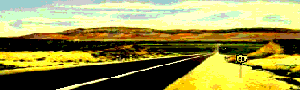
Though you meet the beginnings of the urban sprawl in San Bernadino, it gets even more congested from there forward. From San Bernardino to the Santa Monica Pier, much of old Route 66 disappeared as roads changed, and Los Angeles and its suburbs continued to build and expand.
When Route 66 was created, its purpose was to connect the small towns between Chicago and the Pacific Coast. At that time, many of the Los Angeles suburbs were small towns, filled with mom-and-pop diners, motels, roadside fruit stands, and curio shops.
But in a rush to California, for which Route 66 was partially responsible, the area boomed as travelers escaped the dust bowls of the Midwest, attracted to the climate and opportunities that the Golden State provided.
However, die-hard Route 66 fans can still travel along various alignments of the “original” road, as the path continues to exist along with several thoroughfares to Santa Monica, snaking through suburbs that pass seamlessly into one another. Route 66 is 80 miles of city streets from Pasadena through several Los Angeles suburbs and streets variously known as Foothill Boulevard, Colorado Boulevard, Huntington Drive, Sunset Boulevard, and Santa Monica Boulevard until you reach the western end of the Mother Road at the Santa Monica Pier. If you plan to drive the original route, estimate a full day of frustrating traffic bogs and traffic lights before reaching your destination.
On the other hand, if your goal is to end America’s Main Street, USA, you can take the I-10 from San Bernardino to Santa Monica. Or, better yet, try a combination of streets along the outskirts, transferring to a highway when your frustration level has reached its peak.
If you continue the original route towards Pasadena through the suburbs of Fontana, Rancho Cucamonga, Azusa, Monrovia, and more, you will find several remaining vintage icons if you know where to look between the strip malls and fast-food restaurants.

Wigwam Motel, Rialto, California by Kathy Alexander.
As you begin your trek along the old route, you’ll first come to the San Bernardino of suburb Rialto that was once known for its many lemon groves. At the city’s edge is the infamous Wigwam Motel, which used to rent its rooms by the hour with a sign displaying “Do It In a Teepee.” Serving Route 66 travelers since 1947, these teepee-style cottages have recently gone through a total makeover, including improvements to both the buildings’ interior and exterior as well as the motel’s landscape. The Wigwam Motel is located at 2728 W. Foothill Boulevard.
Continuing along, you will soon reach the suburb of Fontana, which presents a couple of vintage roadside peeks. At the southwest corner of Foothill Boulevard and Sultana Avenue sits a classic Italian restaurant called Bono’s. Unfortunately, as of this writing, Bono’s is closed, and the building is for rent. Right next to it, however, you can see the last of many orange juice stands that once dotted all of California’s Route 66.

Orange Stand in Fontana, California by Kathy Alexander.
Rancho Cucamonga was once known for its many vineyards and orange groves, which numerous businesses have since replaced. The city has become one of the fastest-growing suburbs in the metropolitan area. However, this suburb does provide a couple of Route 66-era opportunities. At Haven Avenue is one of California’s oldest wineries, the Virginia Dare, and at the northwest corner of Foothill Boulevard and Archibald sits the 1920s Richfield Oil station. Dating back to when Route 66 passed through nothing but countryside and vineyards, this place stands out among the more modern views of the road.
Rancho Cucamonga also sports the historic Sycamore Inn, which once stood as a San Bernardino Stage stop. Located at 8318 Foothill Boulevard, this old place has offered great food and friendly service for almost 150 years. While in Rancho Cucamonga, be sure to visit the Route 66 Visitors Center and Museum at 8916 Foothill Boulevard.
Soon, you will arrive at Upland, which features the vintage Buffalo Inn, where buffalo burgers have been served since 1929. Here, in this frontier saloon atmosphere, you can enjoy a burger and brew in a laid-back atmosphere before continuing your journey westward. The Buffalo Inn is located at 1814 W. Buffalo Boulevard.
Next, you’ll come to the city of Claremont, where you can see the Rancho Santa Ana Botanic Garden on the right side of Route 66 just before the intersection with Indian Hill Boulevard.

Azusa, California Drive-In Theater by Kathy Alexander.
As you continue, pay attention as Foothill Boulevard curves slightly to the right, entering Pomona, California, home to the vintage Wilson’s Restaurant at the northwest corner of the intersection with Garey Avenue.
From here, the route takes you through La Verne and San Dimas before arriving in Glendora. Here was the once popular Golden Spur Restaurant, which had a history dating back more than 80 years. There is also a 1940s gas station at the intersection of Alosta Avenue and Loraine. Glendora also sports a quaint downtown district where several buildings haven’t changed for more than a century.
As you continue along Route 66, you will soon come to Azusa, home to the vintage Foothill Drive-in Theatre. The last historic drive-in on Route 66 west of Oklahoma, the vintage theatre, was designated as a California historic resource in 2002.
As you continue, you will pass through Irwindale and Duarte before arriving at Monrovia, which provides numerous views of yesteryear. On Shamrock, one block north of Colorado Boulevard, is a vintage gas station leftover from an earlier alignment of Route 66.

Santa Anita Race Track, Arcadia, California.
Next, you will pass through Arcadia, California, where a 1930s art-deco building stands at Santa Anita Racetrack just beyond 1st Avenue. Designed by Gordon Kaufmann, the architect of the Hoover Dam, the horse track was opened in 1934 and hosted several famous attendees, such as Charlie Chaplin, Clark Gable, Cary Grant, and Bing Crosby.
The track was used as a detention camp for 20,000 Japanese Americans awaiting relocation to internment camps during World War II. Today, the track still serves racing fans and tourists alike, with several restaurants. Also in Arcadia is the historic windmill atop Denny’s restaurant, which preservationists saved from demolition. The windmill dates back to the days when this building was an old Van de Kamp eatery.

Colorado Street Bridge, Pasadena, California.
The next thing you know, you have entered Pasadena, where you can plan on being in congested traffic if you haven’t already. Foothill Boulevard becomes Colorado Boulevard as it moves west into Pasadena. Along this route, several vintage views can be spied amongst the modern buildings, such as the Astro Motel, a 1950s futuristic design that looks a little like a rocket launching pad. Also along this stretch can be seen the stone Holliston Church and the Pasada Motel.
Pasadena’s 22-block historic district showcases more than 200 historic buildings where art deco and 19th-century architecture mingle to form a colorful, eclectic collection. The original center of town has been completely restored and serves as one of Southern California’s most popular nightlife, shopping, dining, and entertainment districts. One delightful view is the Fair Oaks Pharmacy, which opened its doors in 1915 and, through the years, has served Route 66 tourists with thousands of sodas, ice cream floats, and cherry rickeys. The Fair Oaks Pharmacy is located at 1526 Mission Street.
As the Mother Road continues its westward path from Pasadena, two different alignments pass through here. The first crosses the Colorado Street Bridge, which predates Route 66. Initially built in 1913, travelers crossed this arched span until 1940, when the Arroyo Seco Parkway was opened.
On December 30, 1940, the Arroyo Seco Parkway opened, becoming the new official alignment for Route 66. Connecting Pasadena to Los Angeles, the parkway extends through Arroyo Seco’s Arts and Crafts landscape of the early twentieth century and has now been designated as a Federal Scenic Byway. The parkway is significant as the first freeway in the west, representing a transitional time when parkways became freeways. This scenic drive takes you through quiet parks and bustling urban activity; however, according to a UCLA study, the 22-mile parkway is the site of the most traffic accidents in the Los Angeles area.

7th and Broadway, Los Angeles, 1938.
In Los Angeles, 7th and Broadway was the original end of Route 66, and it was extended to Santa Monica in 1935. Here, in downtown Los Angeles, are multiple great examples of 1920s architecture, including the largest concentration of pre-World War II movie palaces in America. Many of these theatres began as vaudeville stages, where live acts like the Marx Brothers and Sophie Tucker entertained the wealthy families of early Los Angeles. With the advent of film, they were transformed into movie theaters.
Following the last alignment of Route 66 to the Pacific Ocean, Santa Monica Boulevard travels through Hollywood, where you can see its famous sign, which has stood as a landmark for generations.
Importing its name from a town in Ohio, the sign once spelled “Hollywoodland” for a real estate development in Beachwood Canyon. Erected in 1923, the sign measures 450 feet long, with each letter rising above the ground almost 50 feet. After maintenance on the sign stopped, it deteriorated severely. However, in 1949, the Hollywood Chamber of Commerce stepped in and offered to remove the last four letters and repair the rest. The sign, located near the top of Mount Lee, is now a registered trademark.
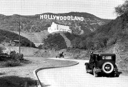
1920s photo showing “Hollywoodland.”
While in Hollywood, numerous attractions are available, including Grauman’s Chinese Theater, the Hollywood Walk of Fame, Universal Studios, and more.
Continuing, you will soon pass through West Hollywood and a theater district filled with trendy shops and boutiques before entering upscale Beverly Hills. While here, you can spend your hard-earned cash at its many pricey shops or grab a map and look for the stars. However, you’re more likely to spot their gardeners than you are the stars themselves.

Santa Monica Pier, California by Kathy Alexander.
Finally, Route 66 ends in Santa Monica at Pacific Palisades Park and the famous Santa Monica Pier. For your final moments along your historic journey, taking a stroll and watching the sunset is a “must.” By now, you no doubt have a camera full of photographs and a mind full of memories that will last you a lifetime.
©Kathy Alexander/Legends of America, updated March 2025.
Also See:
California Route 66 Photo Gallery
See Sources.