
San Bernardino Valley, courtesy Wikipedia.
Though Route 66 travelers encounter the beginnings of urban sprawl in San Bernardino, it progressively gets more congested as you near Los Angeles. Like other large cities on Route 66, such as Chicago and St. Louis, new development has taken over many vintage-era businesses. However, given the growth of America’s second-largest city and its suburbs, there remains a surprising number of historic icons if you know where to look. Taking your time through the many cities along the 60-mile stretch to Los Angeles will offer several picturesque motels, restaurants, signs, and museums for those on the Mother Road.
When Route 66 began, its purpose was to connect the small towns between Chicago and the Pacific Coast, and at that time, most of the Los Angeles suburbs were small towns filled with mom-and-pop diners, motels, roadside fruit stands, and curio shops.
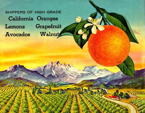
Orange Label 1941.
But in the rush to California, for which Route 66 was partially responsible, the area boomed as travelers escaped the dust bowls of the Midwest, drawn to the climate and opportunities the Golden State offered.
Dedicated Route 66 fans can still travel along the original road, as the path continues to exist along various thoroughfares to Santa Monica, snaking through suburbs that pass seamlessly one into the other. From San Bernardino to Pasadena, the route travels along Foothill Boulevard, now designated California State Highway 66. Traveling through the suburbs of Fontana, Rancho Cucamonga, Azusa, Monrovia, and more, several remaining vintage icons can still be found between the strip malls and fast-food restaurants. However, you must know the city signs to know when you have passed from one suburb into the next.
From Pasadena to Santa Monica, Route 66 is 80miles of city streets through Los Angeles, variously known as Foothill Boulevard, Colorado Boulevard, Huntington Drive, Sunset Boulevard, and Santa Monica Boulevard until you reach the western end of the Mother Road at the Pacific Ocean. If you plan to take the original route, estimate a full day of frustrating traffic bogs and traffic lights before reaching your destination.
On the other hand, if your goal is to make the end of America’s Main Street USA, you can take I-10 from San Bernardino to Santa Monica. Or, better yet, try a combination of streets along the outskirts, transferring off and on the highways if your frustration level reaches its peak.
Rialto, California – Progress From Lemon Groves
Rialto’s “Orange Bowl” has long lost its game by Kathy Alexander December 2005.
The suburb, which now has a population of nearly 100,000 people in its 4 by 8 ½-mile area, began as one of many small towns built along the railroad in 1887. When the railroad line was extended between San Bernardino and Pasadena by the Santa Fe Railroad, 25 town sites were located every 2,600 yards, one of which was Rialto.
That same year, a group of Methodists arrived in the area, planning to build a new college. Though the school was never built, these first citizens formed the new town. By 1893, the fledgling settlement had six businesses, a school, and 35 homes.
In the early part of the 20th century, the area became known for its citrus groves and, at one point, supported seven packing plants that shipped products all over the country. As the town’s population grew, homes and new businesses gradually took over the citrus groves.
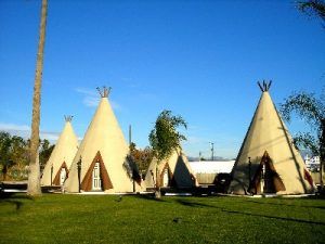
Wigwam Motel, Rialto, California, by Kathy Alexander.
Though much of Rialto is “new, ” several Route 66-era businesses can still be seen, the most famous of which is the infamous Wigwam Motel, which used to rent its rooms by the hour with a sign displaying “Do It In a Teepee.” Serving Route 66 travelers since 1947, these teepee-style cottages have recently gone through a total makeover, including improvements to both the buildings’ interiors and exteriors and the motel’s landscape. The Wigwam Motel is located at 2728 W. Foothill Boulevard at the city’s eastern edge.
Fontana, California – City of Innovation
Some sixty miles east of Los Angeles, you will merge from the suburb of Rialto into the city of Fontana. Originally part of a large Spanish Land Grant, Fontana was officially formed in 1913 by A.B. Miller, who built the town into a diversified agricultural area with citrus, grain, grapes, poultry, and swine being the leading commodities. The settlement remained agriculturally based until Fontana was selected as the site for a steel mill in 1942. A decade later, with a population of nearly 14,000, Fontana became Southern California’s leading producer of steel and related products.
Over the years, Fontana grew quickly and today continues to produce steel products and is home to several other industrial facilities due to its excellent transportation network. Though it now boasts more than 150,000 people, several Route 66 icons can still be seen in Fontana, including several old motor courts on both sides of the road. Long past their prime, the El Rey, Rex, Dragon, Sand & Sage, Rose, and Sunset Motels speak of better times along this old stretch of the highway. That said, Fontana is currently working with the Route 66 Corridor Preservation Program to improve and promote its piece of Route 66 and the continued use of these many historic motels.
At the southwest corner of Foothill Boulevard and Sultana Avenue sits a classic Italian restaurant called Bono’s that served thousands of Route 66 travelers over the years. Unfortunately, as of this writing, Bono’s is closed, and the building is for rent. Right next to it, however, you can see the last of many orange juice stands that once dotted all of California’s Route 66.

During Route 66 heydays, these popular orange stands
dotted the Mother Road. Today, this is the last surviving one, by Kathy Alexander.

Bono’s Restaurant, a long-time Route 66 icon, is long closed, by Kathy Alexander.
Rancho Cucamonga – Premier City of the Inland Empire

The City of Cucamonga in its early days, photo courtesy City of Rancho Cucamonga
Getting its start exactly as its name implies, Rancho Cucamonga was part of a 13,000-acre Mexican Land Grant awarded to Tubercio Tapia, a Mexican soldier and politician, in 1839. Tapia soon built an adobe home on Red Hill, raised large herds of cattle, and began a successful winery, portions of which still exist today as part of the Thomas Winery Plaza. The name “Cucamonga” is thought to have been derived from a Shoshone word meaning “sandy place.”

Established in 1839, the Thomas Winery is California’s oldest winery. This 1930s postcard shows the building as it appeared in 1930. Today, the structure has been preserved and houses a restaurant at the corner of Foothill and Vineyard. Photo courtesy City of Rancho Cucamonga.
In 1858, Tapia’s daughter sold the rancho to John Rains and his wife, Maria Merced Williams, a wealthy heiress. Two years later, the couple hired Ohio brick masons to build them a new home, which is listed on the National Register of Historic Places today and serves as a museum.
In 1861, the couple and their three children moved into the home strategically located at the confluence of the Mojave Trail, the Old Spanish Trail, the El Camino Real, and the Butterfield Stage Route. Rains was well recognized as a wealthy and politically influential man by this time. He was also well-liked and quickly welcomed travelers along the trails into his home. However, the rich and powerful also had enemies, and in November 1862, while Rains was driving his wagon to Los Angeles, he was ambushed near San Dimas. The 33-year-old landowner’s body was found 11 days later, riddled with bullet holes and hidden in the bushes. His murder was never solved.
After Rains’ death, the rancho began to fail, and disputes over water rights became prevalent. By 1870, the Rancho fell into foreclosure and was sold to a banker, Isaias Hellman, and other San Francisco businessmen, who formed the Cucamonga Company the following year. Dona Merced, having remarried, moved with her nearly penniless family to Los Angeles.

The Sycamore Inn has been doing business since 1848, Kathy Alexander.
Though Hellman formed the Cucamonga Homestead Association to develop the new community, his plans were curtailed because of a lack of water. In 1881, a man named Adolph Petch and four other investors opened another track for development just outside the Rancho lands. Spurred by competition, Hellman brought water to his community via waterways dug by Chinese laborers. Irrigation tunnels were continually improved, and before long, the area was cultivated with citrus, olive, peach, and grape crops. In 1887, the two communities combined to form the city of Loamosa. However, in 1913, when the Pacific Electric Railway came through, the town was once again renamed Alta Loma. In the meantime, yet another community called Etiwanda had also sprouted up to the east.
Having long been a city where trails met, it was no surprise when Route 66 was added to the list. In no time, the city boasted motels, diners, and tourist shops to serve the many travelers of the Mother Road.
Once known for its many vineyards and orange groves, Rancho Cucamonga is today one of the fastest-growing suburbs in the metropolitan area. In 1977, Alta Loma, Cucamonga, and Etiwanda merged to form the city, which now has nearly 150,000 people. Though new development has replaced many older buildings, the suburb continues to offer numerous glimpses of its rich history.
Though the vast majority of its agricultural base is gone, the area’s soil remains very fertile, and at various times throughout the year you may still see produce standing along the roadside.
At the northwest corner of Foothill Boulevard and Haven Avenue sits what was one of California’s oldest wineries — the Virginia Dare. This historic building has been transformed into offices but retains its original 1830s architecture.
Nearby, at 10150 Foothill Boulevard, you’ll find Route 66 Memories, a classic antique and gift shop housed in a historic three-story farmhouse. Look for the collection of metallic dinosaurs in the front yard, stop, and browse a plethora of items, ranging from metal sculpture to rustic mission furniture, hard-to-find items, collectibles, and Route 66 memorabilia.

The Richfield Oil Station during its vintage years, photo courtesy City of Rancho Cucamonga Archives
Just a bit further down Route 66, at the northwest corner of Foothill Boulevard and Archibald, sits the Richfield Oil Station or Cucamonga Service Station. The station opened before the Mother Road in 1915 and served Route 66 travelers until the 1970s. This place stands out among the more modern views of the road. In January 2013, Lamar Advertising of Loma Linda, California, donated the land on which the station sits to the Route 66 Inland Empire, California Association, which reopened the building in October 2015 as a museum. For more information, see their website HERE.
Continuing along to Hellman Avenue, look for the New Kansan Motel at 9300 Foothill Boulevard; its name conjures memories of midwesterners escaping during the Dust Bowl days.
On the corner of Vineyard and Foothill sits the old Thomas Winery, the oldest winery in the state. Established in 1839, legend has it that the first owner mysteriously disappeared, leaving hidden treasure undiscovered on the property. The winery, now a California historical landmark, still stands in the building, today called the “Wine Tailor,” along with a coffeehouse and restaurant.

The Magic Lamp Inn has served customers along Route 66 since 1957, Kathy Alexander.
The original 1860s Rains Home, which was once the center of Rancho Cucamonga, has been restored and can be toured at 8810 Hemlock.
Rancho Cucamonga also features the historic Sycamore Inn, which once served as a San Bernardino Stage stop. Located at 8318 Foothill Boulevard, this old place has offered great food and friendly service for almost 150 years.
Nearby, at 8189 Foothill Boulevard, is the Magic Lamp Inn, complete with its genie bottle neon sign.
Serving Route 66 travelers since 1957, you’ll find continental cuisine inside the dark restaurant where the genie bottle perpetuates itself over and over again.
While in Rancho Cucamonga, also be sure to visit the Route 66 Visitors Center and Museum at 8916 Foothill Boulevard.
Upland, California – At the Base of the Foothills

Upland Pride.
Soon you will arrive at Upland, first called North Ontario when George and W.B. Chaffey arrived in the area in 1882. Immigrating from Canada, the pair sought to build a new colony and found the perfect place on lush, fertile ground set against the foothills of the San Gabriel Mountains. After purchasing the land, they began to plan their new settlement. In May 1906, the city was officially incorporated as Upland. The area quickly became a thriving agricultural center, with most of its population involved in producing, shipping, or processing citrus and grapes.
Today, Upland has developed into a residential and retail community that retains its charm.
While in Upland, a great neon sign can be seen at Taco King, 1317 E. Foothill Boulevard, and a classic 1950s-style McDonald’s stands on the southeast corner of Benson Avenue at 1590 Foothill Boulevard. These classic arches are one of the few that remain from our vintage past.
The vintage Buffalo Inn is an absolute “must stop” in Upland, where buffalo burgers have been served since 1929. Here, in this frontier saloon atmosphere, you can enjoy a burger and a brewsky in a laidback atmosphere before continuing your journey westward. The Buffalo Inn is located at 1814 W. Foothill Boulevard.
Claremont – City of Higher Education
Getting nearer and nearer to downtown Los Angeles, Claremont is just about 35 miles this side of the city center. Best known for its seven colleges, tree-lined streets, and historic buildings, the town began as one of the many town sites laid out by the Santa Fe Railroad between San Bernardino and Los Angeles in 1887.
The first of the city’s colleges, Pomona College, was established in the same year. The “New England style” school became the center of the community that grew up around it, reflecting much of the founders’ New England heritage.
Citrus ranches soon spread out around the college; before long, the town sported four citrus packing houses. In addition to its many orchards, the town also began building more colleges; today, the Claremont Colleges Consortium includes five undergraduate colleges, two graduate institutions, and a central organization that provides services shared by all students, faculty, and staff.
The orchards continued to thrive until after World War II, when demand for residential development caused many growers to sell their land. Today, with a population of about 35,000 residents, the town displays its heritage in its many historic buildings, providing various architectural periods.

Padua Hills Theatre, Claremont, 1934.
While in Claremont, you can visit the Rancho Santa Ana Botanic Garden on the right side of Route 66, just before the intersection with Indian Hill Boulevard.
Just beyond sits the Claremont Griswold Center at the northwest corner of Indian Hill and Foothill Boulevards. You can find a theatre, art, shops, and restaurants in a 1911 Art Deco school building.
While not on Route 66, Claremont’s Padua Hills Theatre is a California Landmark that has catered to visitors since 1930. Built as a centerpiece for local artists, the Spanish-Colonial building entertained its patrons until the early 1970s when the City of Claremont purchased the property. Today, it serves as a banquet and meeting facility on six acres of land amongst olive trees, a beautiful central courtyard, and magnificent landscaping. This historic building is located north of Route 66 at the Claremont Hills Wilderness Park base at 4467 Via Padova.
Pomona, California – Goddess of Fruit
As you continue, Foothill Boulevard curves slightly to the right when entering Pomona, California. The city of Pomona began as a Mexican land grant to Don Ingacio Palomares and Don Ricardo Vejar in April 1837. That same year, Palomares and his wife, Dona Concepcion Lopez de Palomares, completed their first home, which continues to stand today as a museum called La Casa Primera de Rancho San Jose. After living there for 17 years, the couple built a grander home a mile north of the first house. The 13-room adobe home was a way station along the San Bernardino Stage and 20-Mule Team freight routes. Called the Palomares Adobe, it still stands today. Both historic homes have been preserved and are open for visits on Sundays.
In 1863, Don Vegar sold his portion of land to two men from Los Angeles, who sold it again to Louis Phillips in 1866. Phillips sold 5,600 acres to a group of speculators in 1875, who began developing the townsite, naming it “Pomona” after the Roman goddess of fruit. That same year, Louis Phillips built the first brick house in the Pomona area, which is now a museum.
Like many other towns in the area, Pomona’s vineyards, olive groves, and citrus orchards flourished until demand for new homes created more and more developments. Today, the city prides itself on its rich history, diversity, and commitment to continuous improvements.

The Pomona Fox Theatre in its heydays, courtesy Pomona Fox website.
Pomona offers numerous glimpses of its vintage past in public and commercial buildings in various architectural styles. One fantastic view of the past can be found at the Pomona Fox Theater at the corner of Third Street and Garey Avenue. Opened in April 1931, the theatre hosted several Hollywood movie premieres in its early days. For decades, the Fox has continued to entertain the public, but suburbanization in Southern California has taken its toll. Falling into disrepair, the Fox was closed, and the building served as a church before being leased out for wrestling matches and rave parties. With its “undesirable” location, the historic theatre soon became the site of gang-related killings until the City of Pomona stepped in and bought the building in 2000. Listed on the National Register of Historic Places, plans are underway to restore this premier example of Art Deco architecture.
On 2nd Street, just east of Garey Avenue, you can find a newly revitalized shopping district called Antique Row. Here are more than a dozen stores featuring hundreds of antique dealers. Across the street is the Art Colony, which houses artists’ studios, galleries, and shops featuring one-of-a-kind items.
The two original homes of the Palomares land grant can be visited on Sundays. The 1837 La Casa Primera is at 1659 N. Park Avenue, and the Palomares Adobe is at 491 Arrow Highway. The historic Phillips Mansion is located at 2640 Pomona Boulevard.
La Verne – Holding on to Small Town Charm
La Verne began in 1887 as the City of Lordsburg, one more town along the Santa Fe Railroad. Isaac W. Lord, a Los Angeles businessman, persuaded the railroad to extend its line through the area where he owned substantial property.
When the railroad was completed, Lord sent brass bands up and down the streets of San Bernardino and Los Angeles, inviting people on a free ride to the new town of Lordsburg. On May 25, 1887, over 2,500 people arrived for Lord’s land sale, the largest in Southern California up to that date. Lord pocketed $200,000 from the sale of lots, and building new homes and businesses began almost immediately.
The town promoters installed water mains and a post office, and construction on the 60-room Lordsburg Hotel began within the first four months. Lord spent $300,000 on the palatial, 96-foot-high hotel that featured cupolas, balconies, domed rooftops, and an electric bell in every room.
Though situated adjacent to the railroad for travelers’ convenience, the land boom had gone bust by the time the hotel was completed. The beautiful hotel never hosted a single paying guest. The hotel’s failure forced Lord to place the building up for sale in 1889. Four German Baptist men bought the vacant hotel with plans to open it as an academy. In the fall of 1891, Lordsburg College was established with 135 students, and the town soon attracted more and more Brethren.
Though the town bore his name, Lord was not well-liked by the residents, and in 1912, they tried to change the community’s name. However, the narcissistic non-resident landowner blocked the attempt. However, five years later, when Lord died, the citizens voted to change the city’s name to “La Verne,” after the northern orange-growing district, and a large celebration was held to mark the occasion. The Lordsburg College also changed its name, today known as the University of La Verne.
As the college grew, it moved into Founder’s Hall, and the original Lordsburg Hotel was torn down in 1927.

The La Paloma restaurant in La Verne, California, by Kathy Alexander.
In addition to the college, most of the fledgling city’s economy was supported by the citrus industry. However, by the 1940s, the quality and size of the fruit had dramatically declined, and groves began to be sold for housing developments.
Today, La Verne supports about 30,000 residents and retains much of its small-town charm on its tree-lined streets. As you enter La Verne, look for Route 66 signage at the Hi-Brow 66 Lounge and Coates Schwinn in the 500 block of East Foothill Boulevard, and just a couple more blocks down the road, a vintage sign advertising the Village Car Wash. Other Route 66 stops include the Route 66 Territory Gift Shop at 2418-D Foothill Boulevard, where you will surely pick up a memento of your trip. If you’re hungry for Mexican food, the La Paloma Restaurant at 2975 Foothill Boulevard has served Mother Road travelers since 1966.
©Kathy Alexander/LegendsOfAmerica, updated November 2025.
Also See:
California Route 66 Photo Gallery
See Sources.


