
Route 66 south from Kingman. Photo by Kathy Alexander.
The Yucca Bypass from Kingman to Topock, Arizona, was a Route 66 alignment built through the area in 1952. This road bypassed the earlier path along Oatman Highway, passing by Cool Springs and Ed’s Camp before crossing Sitgreaves Pass to Gold Road, Oatman, and Golden Shores.
The area around Yucca, Arizona, and its lack of water and other natural resources have long made the region sparsely populated. However, this didn’t stop the Atlantic and Pacific Railroad (affiliated with the Atchison, Topeka, and Santa Fe Railway), which barreled through in about 1881. The railroad built a station and a section house at the site, and before long, ranchers came to Yucca to ship their cattle and area miners to ship their ore. The small settlement soon became a busy waypoint for cargo and passengers and was officially established in 1883, but it grew slowly. In 1905, a post office was established.

Santa Fe Railroad through Yucca, Arizona by Jack Delano, 1943.
At about the same time, tungsten was discovered to the east of Yucca, though little was done about it until 1915, when it began to be actively mined. The veins were then worked from 1915 until the price decline in 1919 made production unprofitable. However, the mine would be worked intermittently for years. This production brought more people to the area.
In 1913, a segment of the National Old Trails Road, the precursor to Route 66, was added from Needles, California, to Kingman, Arizona, along the Sacramento Wash through the Yucca area. Portions of the road are still used today, as evidenced by the Old Trails Road Interchange along Interstate 40, approximately one mile north of the Yucca townsite. In 1924, a one-room school was built and later expanded. The building still survives today.
When Route 66 was first built in the 1920s, several supporters worked to have the highway run parallel to the railroad through Yucca. However, Oatman was at its peak as a mining community and had more clout. So, even though it made the drive more complex and longer on those old Model-Ts, the original route took the hazardous journey up Sitgreaves Pass, bypassing Yucca.

Old Whiting Bros Complex, Yucca, Arizona.
In December 1942, during World War II, an Air Force Gunnery School was established in nearby Kingman, with a sub-base in Yucca. However, when the war ended, these people left the area, and at about the same time, ranching and mining began to decline.
The only thing that saved the town from becoming a “ghost” at that time was the rerouting of Route 66 in October 1952. At that time, Route 66 was rerouted to bypass Oatman, making the drive to California easier and faster. At that point, numerous tourist courts, cafes, and service stations sprouted up, including a Whiting Brothers truck stop.
Making things even better for small-town Yucca was the Ford Motor Company’s purchase of the old Air Force grounds and establishment of the Arizona Proving Grounds for vehicle testing in June 1955. With dozens of people employed, the future looked bright for the community. Today, the grounds, which include an oval five-mile high-speed track, a low-friction test track for skidding and braking, and an 18-acre paved vehicle dynamics area for cornering and steering, remain operational but are owned by the Chrysler Corporation.

Abandoned Cafe in Yucca, Arizona.
The Yucca Fire District was established in July 1962 to serve Yucca and the surrounding area, encompassing 125 miles. Unfortunately, Yucca’s heydays wouldn’t last. In the early 1970s, Interstate 40 replaced the section of Route 66 going through Yucca. Though exits from the Interstate were built to Yucca, it wasn’t enough to keep the old services open. Soon, one more of the many Whiting Brothers Complexes “bit the dust,” as did several other service businesses.
For the last several decades, Yucca’s population has continually declined. However, the unincorporated community still boasts a school, post office, convenience store, restaurant, bar, and a population of about 250 people. One popular destination is the Stage Coach Trails Guest Ranch, a dude ranch with 360,000 acres of natural western desert land at the foot of the Mohave Hualapai Mountains.
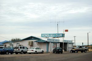
Honolulu Club at Yucca, Arizona, by Kathy Alexander.
Of vintage Route 66, travelers can still see a few fading signs and the ruins of old businesses, including old cafes, motels, and service stations. Other quirky photo opportunities include a semi-truck perched high on a pole on the east side of Interstate 40, just north of Exit 25, which was once associated with a garage next door, and a golf ball-looking building, south of Exit 25, west of the interstate, that was once associated with a land development company that went bust.
Yucca is 24 miles southwest of Kingman, Arizona, and 38 miles east of Needles, California.
Beyond Yucca, there is little to see along the steaming desert highway besides dozens of large billboards enticing visitors to Lake Havasu to the South. Travelers should settle in for the next 25-mile stretch until they reach the wide Colorado River at Topock.
©Kathy Alexander/Legends of America, updated April 2026.
Also See:

Golf Ball Building in Yucca, Arizona by Kathy Alexander.
Kingman to California Route 66 Photo Gallery
Route 66 Alignments From Kingman to California
Sources:
Around AZ
Never Quite Lost
Snyder, Tom; Route 66: Traveler’s Guide and Roadside Companion; St. Martin’s Press, New York, NY; 2000
Wikipedia


