Mileposts 40-60
| Milepost | Point of Interest: |
| 40 | Port Gibson – This historic town is Mississippi’s third oldest settlement, occupied in 1729. Most of Port Gibson’s historic buildings survived the Civil War because General Ulysses S. Grant believed the city was “too beautiful to burn.” Historic Church Street through the middle of town is lined with antebellum homes and church buildings. |
| 41 | Side Trip – Grand Gulf Military Monument Park – In May of 1962, the Grand Gulf Military Monument Park was officially opened, dedicated to preserving the memory of the town and the battle which occurred there. Located eight miles northwest of Port Gibson, Mississippi, off Highway 61, this 400-acre landmark is listed on the National Register of Historic Places. It includes Fort Coburn and Fort Wade, the Grand Gulf Cemetery, a museum, picnic areas, hiking trails, an observation tower, and several restored buildings dating back to Grand Gulf’s heyday. The museum and grounds fee is only $3.00 for those under 60 years young, $2.00 for those over 60, and $1.00 for students K-12th grade. It is located ten miles from the Natchez Trace Parkway. Exit at milepost 41 onto Mississippi Highway 18 and drive into Port Gibson. Take Anthony Street out of town from the courthouse area in Port Gibson, heading northwest. Anthony Street becomes Oil Mill Road. Oil Mill Road dead-ends into Grand Gulf Road. Turn left on Grand Gulf Road and follow the road to the park. |
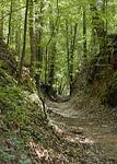
| 41.5 |  The Sunken Trace – One of the most photographed sites along the parkway, the trace appears sunken in this spot due to thousands of travelers walking on the easily eroded loess soil. Hardships of journeying on the Old Trace included heat, mosquitoes, poor food, hard beds (if any), disease, swollen rivers, and sucking swamps. Take five minutes to walk this open trail and let your imagination carry you back to the early 1800s when people walking 500 miles had to endure these discomforts and where a broken leg or arm could spell death for the lone traveler. The Sunken Trace – One of the most photographed sites along the parkway, the trace appears sunken in this spot due to thousands of travelers walking on the easily eroded loess soil. Hardships of journeying on the Old Trace included heat, mosquitoes, poor food, hard beds (if any), disease, swollen rivers, and sucking swamps. Take five minutes to walk this open trail and let your imagination carry you back to the early 1800s when people walking 500 miles had to endure these discomforts and where a broken leg or arm could spell death for the lone traveler. |
| 45.7 | Mangum Mound – The excavation of this site tells us much about the people of the late prehistoric period. The Plaquemine culture included the ancestors of the modern tribes of Mississippi and Louisiana. It was a society with elaborate agriculturally oriented religious ceremonies. From the burials on this mound, it is known there was high infant mortality, and upon the death of a chief, a brutal ritual was enacted in which his retainers were slain and buried with him. |
|
Grindstone Ford – This ford marked the beginning of the Choctaw Nation’s wilderness and the end of the Old Natchez District. Nearby, Fort Deposit was a supply depot for troops clearing the Trace in 1801-1802, and troops were assembled here during the Burr conspiracy allegedly to separate the western states from the Union. The site takes its name from a nearby watermill. A trail leads to the Old Trace and Grindstone Ford. Riverboatmen on foot or horseback crossed northbound, after floating cargo down to Ohio and Mississippi Rivers to New Orleans. Soldiers splashed across from the north to protect the Natchez District from British and Spanish threats. For post riders, Indians, bandits, and preachers, Bayou Pierre was the line between civilization and the wilderness. Daniel Burnett’s stand stood near here. Burnett was the speaker of the Territorial House of Representatives, a principal negotiator with the Choctaw, and a framer of the state constitution, but his stand was unpretentious. His guests supped on mush and milk in a room filled with their gear and Burnett’s supplies. |
|
| 52.4 | Owens Creek Waterfall – The sounds of a busy woodland stream and the murmur of a lazy waterfall have long been stilled here. Water fills the stream and sets the waterfall singing only after heavy rainfall. Over the years, the water table has dropped several feet, and the spring that feeds Owens Creek has disappeared. Little remains of a scene that was once familiar to residents of Rocky Spring Community. |
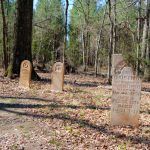
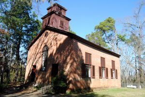
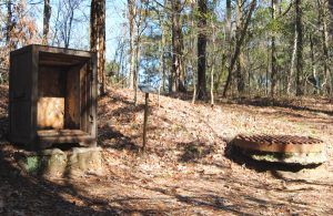
| 54.8 | Rocky Springs – Once a prosperous town of more than 2,500 people, Rocky Springs is home to only a single church and a cemetery today. The old townsite and the surrounding area is maintained as a historic site by the National Park Service. A short one-half-mile trail at milepost 54.8 allows you to walk through the abandoned town of Rocky Springs. In addition to the short trail, there is a picnic area, restrooms, and a campground. All campgrounds on the Natchez Trace Parkway are primitive and have no hookups. The sites are available on a first-come, first-served basis with no reservations. |
Continue to mileposts 61-108 next page


