Natchez Trace Parkway from milepost 269 to 308
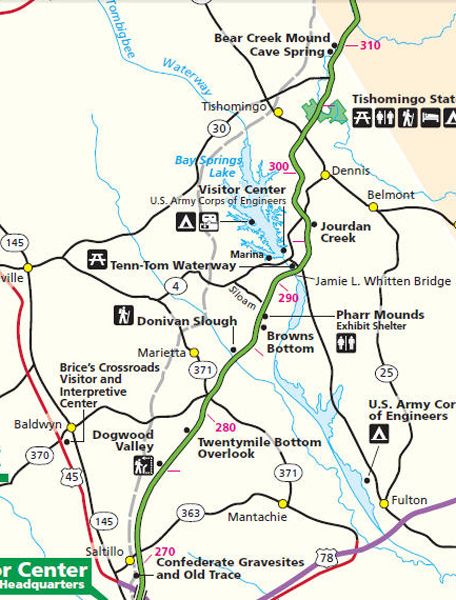
| Milepost | Points of Interest: |
| 269.4 | 
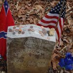
Small Confederate Cemetery – A short walk on the Old Trace will take you to 13 Confederate gravesites. The identity and cause of death of these 13 Confederate soldiers remain a mystery. |
| 275.2 | Dogwood Valley – Flowering dogwood is a common small tree throughout the eastern United States from Maine and Michigan south to Texas and Florida. Here the Natchez Trace passes through a small valley with an unusual stand of large dogwood trees. An easy 15-minute walk takes you along a sunken portion of the Old Trace and through the small wooded area named Dogwood Valley. |
| 278.4 | Twentymile Bottom Overlook – Now cultivated, this area was typical of the many low areas along streams through which the Natchez Trace passed. In 1812, Reverend John Johnson stopped at old Factors Stand near this bottom and wrote this account of bottomland travel, “I have this day swam my horse five times, bridged one creek, forded several others besides the swamp we had to wade through. At night we had a shower of rain. Took up my usual lodging on the ground in company with several Indians.” |
| 282 | Side Trip – Brice’s Cross Roads National Battlefield – Brice’s Cross Roads was the site of a significant Civil War battle on June 10, 1864. The Brice’s Cross Roads Visitor and Interpretive Center is close to U.S. Highway 45 and Mississippi Highway 370. The visitor center’s “Forrest’s Finest Hour” exhibit tells the story of the battle, the opposing armies, and the leaders and personalities involved. It also preserves and displays a collection of interesting Civil War artifacts, many from Brice’s Cross Roads Battlefield. The battlefield Site can be reached by exiting the Trace at milepost 282 onto Mississippi Highway 370 and traveling west 11 miles to Baldwyn and then five more miles west to the battlefield site. |
| 283.3 | Donivan Slough – This woodland trail takes you through a lowland where rich soil and abundant moisture support a variety of large water-tolerant trees, including tulip poplar, sycamore, and water oak. Bald cypress thrives in the swampy backwaters of a slough or channel while winding through the bottomland. A 20-minute walk lets you see these trees and the dramatic way the bald cypress grow only in the wet slough. |
| 286.7 | 
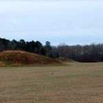
Pharr Mounds – Pharr Mounds is the largest and most important archaeological site in North Mississippi. Eight large, dome-shaped burial mounds are scattered over 90 acres. These mounds were built and used about 1-200 AD by a tribe of nomadic Indian hunters and gatherers who sometimes returned to this site to bury the dead with their possessions. Interpretive signs explain the mound-building process and life in the village. |
| 293.2 | Tennessee-Tombigbee Waterway – In the mid-1770s, Sieur de Bienville, the founder of Mobile, Alabama, recommended to Louis XIV a waterway connecting the Tennessee River with the Tombigbee River. Later, American settlers also recognized the advantages of such a shortcut. Knox County, Tennessee’s residents first approached Congress in 1810 with a proposal to connect the two rivers. The Army Corps made the first survey of Engineers in 1827. Serious consideration was delayed for more than a century due to the expansion of railroads. Construction of the Tenn-Tom Waterway was started in 1972 and was completed in 1985. The waterway provides shallow-draft boats and barges operating in some 16,000 miles of other navigable inland waterways with access to the Gulf of Mexico at Mobile, Alabama, 412 river miles to the south of the Bay Springs Lock and Dam. The junction of the waterway at the Tennessee River is 47 miles north of the lock and dam. The lock on the waterway is a standard dimension, 110 feet wide and 600 feet long. The U.S. Army Corps of Engineers administer the Tennessee-Tombigbee Waterway and visitor center. |
| 293.4 | Bay Springs Lake – Located on the east side of the Tennessee-Tombigbee Waterway, the lake and dam area are to the north. In the 1840s, George Gresham erected a water-powered sawmill and gristmill at the narrow rocky gorge on Mackey’s Creek. Rock overhangs in the gorge provided shelters that had been inhabited by Indians thousands of years before. In 1862, Gresham and two partners founded the Bay Springs Union factory. This company contained the original saw and grist mill and added a mill for spinning cotton yarn and carding wool. This small industrial center included a mill and a cotton gin, a blacksmith, a post office, and a general store. In 1885, the factory was destroyed by fire and never rebuilt. |
| 303 | Side Trip – Tishomingo, Mississippi – About two miles north of the Natchez Trace Parkway, Tishomingo is named after Chief Tishomingo of the Chickasaw tribe, who signed the Treaty of Pontotoc in 1832. He died on the infamous Trail of Tears. His son, Iuka, is the namesake of the county seat of Tishomingo County, Mississippi. The population of Tishomingo is just over 300 people. |
| 304.5 | Tishomingo State Park – The Trace goes through Mississippi’s premier nature park, which straddles the Parkway. From 1750 to 1836, Chieftain Tishomingo and his Chickasaw tribesmen traveled this famous trail over Saddleback Ridge into Freedom Hills, their happy hunting ground. There are small, day-use entrance fees at the state park. |
| 308.4 | Cave Spring – The description of the ground surface and the type of rock indicate that this cave resulted from a solution activity. The underground water dissolved a long room and corridor out of the rock. The roof of the room eventually weakened and collapsed. Indians may have used this site as a source of water and stone. The water is now unsafe to drink, and the cave is dangerous. |
| 308.8 | Bear Creek Mound – A village site was occupied as early as 8,000 B.C. by hunters who stayed only long enough to prepare their kill. From the time of Christ to 1000 A.D., migratory people of this area practiced limited agriculture. The nearby fields and streams offered an abundance of nuts, fruits, game, and fish. These people shaped this mound and built a crude temple on its summit to house their sacred images. |
Continue to mileposts 308 to 338

