
Fort Leavenworth, Kansas.
The Fort Leavenworth-Fort Gibson Military Road was created in 1837 and designated as the “permanent Indian Frontier” borderline, which ran as far north as Fort Snelling, Minnesota, and as far south as Fort Towson, Oklahoma. This portion of the larger military pathway ran between Fort Leavenworth, Kansas, and Fort Gibson, Oklahoma.
The Indian Removal Act of 1830 established a federal policy to remove all Indian tribes from the Eastern states to lands west of the Mississippi River. However, the government’s policy to remove the Indians from the interior of the States beyond our western boundary required a regular defense system.
In 1834, Congress passed the Intercourse Act “to regulate trade and intercourse with the Indian tribes, and to preserve peace on the frontiers.” The areas where the Natives were settled were restricted to white settlement. This act further defined the government’s policy towards the Indians. It provided strict regulations for relations between the white settlements and the Indian country and used U.S. military forces to make the act effective.
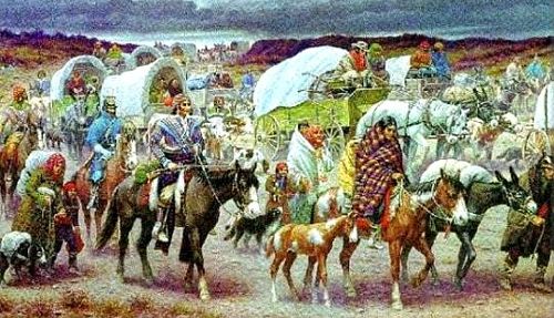
Indian Removal on the Trail of Tears by Robert Lindneux
By 1835, more than 30,000 Indians, principally the Creek, Choctaw, Cherokee, and Shawnee, had been settled in territory immediately west of Missouri and Arkansas.
Because no natural barriers existed and because troops at the outlying army posts of Forts Leavenworth, Gibson, and Towson were insufficient to police the border country, Congress was faced with the problem of enlarging the frontier defense and patrol system.
On December 23, 1835, the senate instructed its committee on military affairs to “inquire into the expediency of making an appropriation to construct a military road from Cantonment ‘Des Moines’ to Cantonment Leavenworth, thence to Fort Gibson… Secretary of War Lewis Cass advised the committee:
“I have no doubt that a road from the western bank of the Mississippi to Fort Leavenworth and thence to Fort Gibson would be very advantageous to the United States. It need not be an expensive work. Cutting down the timber for a reasonable width, bridging the streams, and causewaying the marshy places, so as to allow the free movement of troops, would be all that would be necessary. . . . From Fort Leavenworth to Fort Gibson the route would pass west of the State of Missouri and the Territory of Arkansas, and through the lands assigned to the emigrating Indians. It will be essentially necessary that the United States should not only possess a respectable force in this quarter but that they should have the means of transporting it freely along this line of communication.”

Fort Gibson, Oklahoma Historic Site by Kathy Alexander.
Congress approved the Fort Leavenworth-Fort Gibson Military Road in 1836. Before long, a plan was made to divide the longer road into three sections. The northern section was from Fort Snelling to Fort Leavenworth; the middle section, between Fort Leavenworth and the Arkansas River; and the southern, from the Arkansas River to Fort Towson. Separate commissions surveyed the three sections, and in August 1837, Civil Engineer Charles Dimmock and an assistant were employed to survey the middle section and made their way to Fort Leavenworth. In September, they set out for the Arkansas River, exploring along the way, accompanied by a small dragoon escort. The survey began on September 27 at a point just across the Arkansas River from Fort Coffee. It was completed at Fort Leavenworth on October 8. The 286-mile route was marked, and the commissioners recommended two locations for new military posts.
By May 1842, Fort Scott, Kansas, was built a few miles beyond Missouri’s border on the Western military road. Within no time, infantry and dragoon troops were moving regularly on the military road. Soldiers from the fort also used a portion of the road to reach the Santa Fe Trail in Johnson County, Kansas, to escort Santa Fe traders’ caravans. The route also carried soldiers destined for the Mexican-American War in 1846-1848.
“This morning got an early start & marched 12 miles camped on a beautiful plain on the banks of a fine clear stream of water, with plenty of wood near at hand. This day, we saw several volunteers returning home who had gone out under General Kearney last summer. They did not look like “men in Buchram,” but real “Rough and Readys.”
— Private Benjamin Wiley, describing Gum Springs south to the Santa Fe Trail, July 7, 1847

Officer Row, Fort Scott, Kansas by Kathy Alexander.
Fort Scott was a frontier post for nearly 12 years until it was abandoned in 1853, the year before the organization of Kansas territory. Some of the buildings erected in the 1840s remain today within the town of Fort Scott.
The old road faded from memory after the Civil War, but for over 30 years, it was an essential route for the frontier military and other travelers.
Today, a portion of this road has been designated as the Frontier Military Scenic Byway. It extends along the eastern edge of Kansas for about 167 miles, from Fort Leavenworth to Fort Scott and then onward to the Oklahoma border. It follows K-5 out of Leavenworth to I-435, then U.S. 69 and Alternate U.S. 69 to the state line.
Along the route are several historic, natural, and cultural sites, including Fort Leavenworth, Leavenworth Landing Park, Grinter Place, the National Agricultural Center and Hall of Fame, the Johnson County Museum, Legler Barn Museum, Mahaffie Stagecoach Stop, Louisburg Cider Mill, the John Brown Museum, Marais des Cygnes Massacre Park, the Chouteau Trading Post, Mine Creek Civil War Battlefield Site, Fort Scott National Historic Site and Cemetery, a prehistoric and Osage Indian site, and “Big Brutus” the second-largest electric coal shovel in the world and Schermerhorn Park.
Travel through time, experiencing the turbulent era of Bleeding Kansas, its territorial struggles, the Civil War, and more.
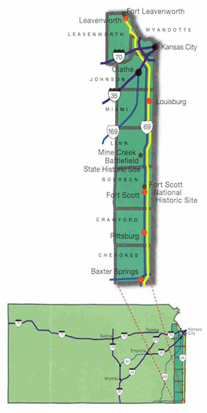
Military Byway courtesy Natural Kansas.
©Kathy Alexander/Legends of America, updated April 2025.
Also See:
Sources:
Historical Marker Database
Kansas State Historical Society
Natural Kansas
Travel Kansas