Battle of Champion Hill (May 16, 1863)
Battle of the Big Black River Bridge (May 17, 1863)
Map of Battle and Historic Sites
Although the Vicksburg Campaign encompassed much more than the 45-mile stretch between Jackson and Vicksburg, two crucial Civil War battles took place in this area that may very well have changed the way history is read today. Playing a pivotal point in the ultimate defeat of Vicksburg, the Battle of Champion Hill was fought on May 16, 1863, and the Battle of the Big Black River Bridge was fought the following day.
Though officially recognized, these crucial battles are not well known in history books. Road names have been changed, most sites are not well marked, and many are situated on private property, making research and writing about these historic sites more difficult.
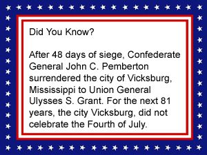
“I think it due to myself to state emphatically that the advance movement of the army from Edwards Depot on the afternoon of May 15 was made against my judgment, in opposition to my previously expressed intentions, and to the subversion of my matured plans. ”
– Confederate General John C. Pemberton
Area Battle Sites and Historic Places:
(others on the map not in this article)
Edwards Station
Old Highway 80
Raymond Road
Isaac Robert’s House
Tilghman Monument
Vicksburg-Jackson Railroad
Yeiser House
Sites, Places, and Markers:
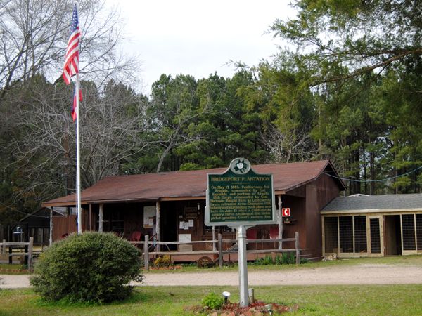
The office/store at Askew’s Landing once served as the Plantation Commissary
Askew Landing and the Bridgeport Plantation – As the Confederates fled their defeat at the Battle of Champion Hill, returning to Vicksburg, they took several routes. One group barreled through the old Bridgeport Plantation, just northeast of Edwards. Located near the Big Black River, the plantation was established by Duklet Askew in 1859. Skirmishing on the river, the Confederates made their way across, burning the ferry after making good their escape. The old plantation is a National Registered Historic site and an RV Campground today. This hidden gem has a long and fascinating history. Read its story HERE.
Baker’s Creek and Champion Hill Road – This road was one of two avenues of escape open to Lieutenant General John C. Pemberton’s army after their defeat at the Battle of Champion Hill. Early in the afternoon of May 16, 1863, Union battle lines extended beyond the Confederate left flank and threatened to seize their position. A Southern counterthrust failed, and by mid-afternoon, the escape route was closed, leaving the Confederates only at the Raymond-Edwards Road crossing of Bakers Creek to make good their escape. Champion Hill Road closely approximates what was once called Clinton Road. The site of the old Midway Station and the Champion family cemetery are located on Champion family property and cannot be publicly accessed without arranging for a private tour. The site where the Champion House once stood is just to the east of the Champion family property, located at the site of the Missionary Baptist Church. Unfortunately, this site was also not accessible, as the road to the church is beyond locked gates.
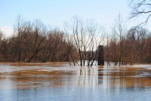
Big Black River Pier
Big Black River – A tributary of the Mississippi River, it flows about 330 miles in a generally southwest direction from Webster County in the north-central part of the state until it merges with the Mississippi River about 25 miles south of Vicksburg. In the early days and today, portions of its flood plain can turn into virtual swamps during heavy rains. However, this was learned early on by early frontiersmen, who rarely built their homes or businesses too near the river’s banks.
When the area was first settled, the river was forded by several individuals who operated ferries, including the Fox, Birdsong, Baldwin, Cox, and Askew Ferries. The Baldwin Ferry was destroyed during the Battle of the Big Black River. The Askew Ferry was destroyed when Confederate soldiers were fleeing their defeat at Champion Hill.
On May 17, 1863, the Civil War Battle of the Big Black River Bridge occurred here. This Union victory sealed Vicksburg’s fate, as the Confederate force was bottled up there.
After the Civil War, the rivers and streams were sometimes the only means of access to some of the interior rural regions of Mississippi. However, the Big Black River was hard to navigate with its impenetrable swamps, snags, logs, and forests lining some sides. Bridges began to be built in the early 20th century to replace the many ferries.
Bolton – Located about 19 northwest of Jackson and just four 1/2 miles from the Champion Hill Battle site, no conflicts took place within this small town; however, the night before the Battle of Champion Hill, Union General James B. McPherson’s army corps camped at Bolton, near the junction of the Jackson Road and the Raymond-Bolton Road. Part of Union General John Alexander McClernand’s troops were camped further south on Raymond-Bolton Road, which intersects with the Middle Road. This force included McClernand himself, along with divisions of Peter J. Osterhaus and Eugene A. Carr. The southernmost force was camped near the intersection of the Raymond-Bolton Road and the Raymond Road, which included divisions of A.J. Smith and Francis P. Blair.
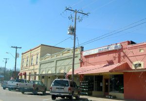
Though Bolton is tiny — with only about 600 residents, it still has several surviving businesses by Kathy Alexander.
Although the Union army was spread over miles of road, their disposition allowed quick transportation down the narrow, mud-choked Mississippi roads. At 5:00 a.m., Union General Ulysses S. Grant ordered all forces westward toward Edwards Station. Most of Vicksburg’s defenders were between the Union Army and Edwards Station.
Today, tiny little Bolton supports just a little over 600 people but still continues to boast a number of remaining businesses, including a cotton gin, a bank, and several active churches. The railroad is also still active. Like other small towns located near larger cities, many of its business buildings are vacant; however, Bolton still shows its pride in a well-kept, friendly, and charming manner.
Bridgeport Road – This historic road, which once connected the capital city of Jackson to Vicksburg on the Mississippi River, was the first route built by the state of Mississippi through the frontier region then known as the Choctaw Session, which the state acquired in the Treaty of Doak’s Stand. The road, built between 1822 and 1825, was named for the now-extinct community of Bridgeport, which stood at the crossing of the Big Black River. In the 1840s, the trail was designated a federal Post Road and served by daily stagecoach service. At this time, when Bridgeport Road crossed the Big Black River, the Ferry was used to shuttle wagons, stagecoaches, and other travelers across the river. The road was used extensively by Union and Confederate troops before, during, and after the Siege of Vicksburg and the occupation of Jackson.
Bridgeport Road near Bolton
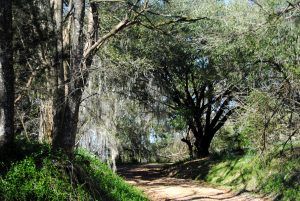
After the War of Rebellion, traffic shifted toward railroad communities to the south, and the Old Bridgeport Road declined. Today, most of the original route has been replaced by more modern roads that go by different names. Other sections have been abandoned entirely. However, there is a 3/10-mile section northeast of Bolton, Mississippi, that is still in use in its original condition. A designated Mississippi Landmark, this small slice of the old trail is a narrow, graveled section overhung with mature oak trees.
Not too many years ago, this section of the historic road was listed among the top 10 most endangered historic Mississippi properties in 2005. At that time, plans were to bulldoze and widen this last original segment, which borders a listed Native American site, a Union Army camp, the Holly Grove Plantation House, which is listed on the National Register of Historic Places, and an African American, cemetery believed to have its origins as a slave cemetery. The Mississippi Heritage Trust saved the site. Soon, a nearby landowner, Gaddis & McLaurin Farms, donated an easement to the county to build a new road north of Old Bridgeport Road to access a small group of houses that had previously used the historic route. Once the new road was complete, the county abandoned the Old Bridgeport Road, which reverted to private use. As a result, the Old Bridgeport Road is preserved in its historic condition. Some old sections of Bridgeport Road can be seen at Askew’s Landing near Edwards.
The Battle of Champion Hill, Mississippi
Champion Hill—The core of the Battle of Champion Hill took place in this area on Champion family property. It took place on May 16, 1863, and has also been referred to as the Battle of Baker’s Creek. The conflict was led by Union Major General Ulysses S. Grant and Confederate Lieutenant General John C. Pemberton. The Union victory resulted in an estimated 2,457 Union and 4,300 Confederate casualties. The site can only be accessed via a privately arranged tour.
For Civil War buffs, touring this area can be frustrating or interesting — like a scavenger hunt, depending upon how you look at it. There are very few historical markers or monuments in the area, and many are deteriorating and need repairs or updates. We could not find any “tour guide” or map — official or unofficial. Old maps exist, but all of the road names have changed. Many of the roads themselves are poorly maintained. And finally, many of the sites are on private property and are inaccessible. However, with research, we were able to find a number of these sites and have provided a map for those who wish to take a look at where these pivotal battles leading up to the defeat of Vicksburg took place. (See map HERE.)
The Champion Hill area’s battlefield and some of the original roads are very well preserved. However, there are no original buildings. Thousands of acres of the core battlefield are privately owned, and another 800 acres of the outlying area are owned by the State of Mississippi. The Civil War Preservation Trust has protected 402 acres through conservation easements and land purchases. There is hope that parts of these properties may become an extension of the Vicksburg National Military Park.
Champion House – In 1853, the land now known as Champion Hill was given to Sid and Matilda Champion as a wedding present from her father, Eli Montgomery. They erected a two-story white frame house on the Old Jackson Road overlooking the railroad near Midway Station. Sid joined the 28th Regiment Mississippi Cavalry in Vicksburg, Mississippi, in 1862, leaving Matilda in charge of the plantation. Her worst fears came true on May 15, 1863, when she heard Union Major General Ulysses S. Grant’s army marching westward from Clinton toward Vicksburg. She gathered her four young children and fled to her parent’s home in Madison County. The next day, the Battle of Champion Hill was fought, primarily on the Champions’ property. The house served as a Union hospital and was later burned by Union soldiers. After the Siege of Vicksburg, Sid fought in the Atlanta and Tennessee campaigns. In 1865, Sid and Matilda returned to Champion Hill and built a modest house at Midway Station. Sid died three years later at the age of 45. Matilda died in 1907 at the age of 80. Both are buried in the family cemetery. The original Champion home and the historical marker are located on land where the Champion Hill Baptist Church sits today. Unfortunately, the church was inaccessible during Legends’ visit, as the road is behind a large locked gate. It is located west of Chapel Hill Road, just south of Champion Hill Road.
The Coker House, east of Edwards, MS, was utilized as a hospital after the Battle of Champion Hill.
Coker House – Early on May 16, 1863, Confederate troops under General William W. Loring were deployed on the ridge facing east. Union forces advancing from Raymond formed a battle line approximately 1,000 yards east, where they readied their artillery. A sporadic artillery duel ensued for hours, causing little damage to either side. At mid-afternoon, Loring was directed to send two of his three brigades to the endangered Confederate left near Champion Hill. His remaining brigade — that of Brigadier General Lloyd Tilghman — was withdrawn to the next ridge west of the Coker House. Immediately following the withdrawal of Confederate forces, Union troops took possession of the ridge. Six guns of the Chicago Mercantile Battery were positioned between Raymond Road and the Coker House, which was eventually utilized as a field hospital for soldiers of both the North and South. When the Union departed the house, they extensively looted the home and the plantation stores.
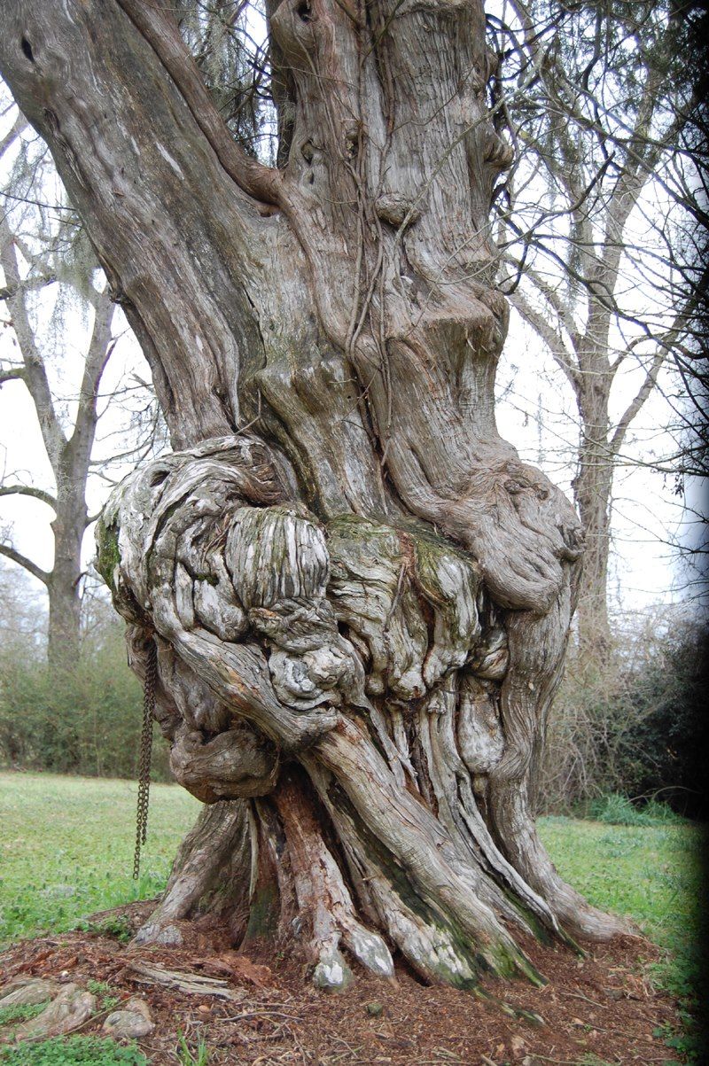
This tree at the Coker House caught my eye. Did it grow like this, or did the character of the history implant itself? What do you see? (comment on this article below) Photo by Dave Alexander.
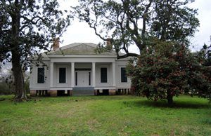
The Coker House is a one-story Greek Revival house built in 1852 by a popular citizen and farmer, H.B. Coker. The interior layout followed the traditional central hall plan, having two rooms on each side. For almost 150 years, the house continued to stand, complete with bullet holes in the front door and jambs and cannonball holes on the west side of the structure, testifying to its witnessing of the bloody and decisive Battle of Champion Hill.
Over the years, the house fell into extreme disrepair, but it remained the only remaining structure associated with the Battle of Champion Hill. In 1985, the historic property was donated to the Jackson Civil War Roundtable and later deeded to the Mississippi Department of Archives and History. However, by 2005, the house was in ruins, and the decision was made that refurbishment was impossible. The house was razed in 2006; however, much of the original materials were saved, and the house was rebuilt, utilizing original items when possible. Historical marker plaques at the house detail the battle and the house’s history. The Coker House stands adjacent to a south portion of the Champion Hill battlefield, located about four miles east of Edwards on Mississippi Highway 467.
Cook Plantation – In the late 1830s, a planter from North Carolina named McKinney L. Cook and his wife, Jennette Winters Cook, purchased some 800 acres of land near the now-extinct town of Amsterdam (now part of Edwards.) A successful planter, Cook built a magnificent two-story Greek Revival-style mansion in 1852. Less than a decade later, when the Civil War broke out, the Cooks began to suffer like many other Southern families. On May 16, 1863, Confederates who were fleeing from their defeat of Champion Hill raced through the plantation. Not far behind them, Union troops were in hot pursuit. When the soldiers had left, the plantation was in ruins, but the mansion still stood. It would become a school for African Americans when the war was over. Though closed today, the site is on the National Register of Historic Places and has a long and interesting history. Though the old mansion no longer stands, several more buildings from its academic era still do. Currently, the site is virtually unused and heavily posted against trespassers. It is located at 18449 Old US 80 on the west side of Edwards, Mississippi.
Crossroads – An important site during the Battle of Champion Hill, this intersection of several roads controlled much of the battlefield action. The Confederate line, as established on the morning of May 16, 1863, extended from the Crossroads to the Ratliff Road and controlled both the Middle Road and the Raymond Road. Unknown to the Confederate high command, however, strong Union columns were pushing down the Jackson Road from Bolton. This would place the Federals on the flank and in the rear of the Confederate army. The movement was discovered in time, and Confederate troops were rushed to the crest of Champion Hill, but the decisive Union advance stormed the hill and drove the Southerners back beyond the Crossroads. Early that afternoon, Brigadier General John S. Bowen’s Confederate division, positioned on the Ratliff Road, charged with a vengeance and regained control of Champion Hill. When Federal troops broke through the roadblock on the Middle Road, 600 yards to the east, Bowen’s position became untenable, and he was compelled to retreat. With the battle lost, Confederate troops left this area via the Ratliff Road and fled to the lower crossing of Baker’s Creek.
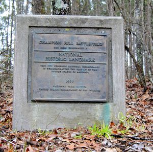
Champion Hill Battlefield National Historic Landmark marker.
Today, the Crossroads is located at the intersection of Billy Fields Road. A historical marker commemorating the Battle of Champion Hill sits at this important intersection. The concrete marker, with a bronze plaque, was erected in 1977 by the National Park Service. It sits high on the ridge of the road and can be difficult to see, effortlessly blending in with its surroundings. At the time of the battle, the Jackson Road veered north at the Crossroads, making its way to the crest of Champion Hill, 800 yards away. The trace of the old road can still be seen. The paved road leading to this site was referred to as the Middle Road (now Billy Fields Road), and the road running west from this point was the Ratliff Road.
Davis Plantation/Ellison House – On May 15, Confederate commander Lieutenant General John C. Pemberton established his headquarters in the home of Sarah Ann Walton Bowles Ellison. With skirmishers well in front, the Confederate army manned a roadblock at this point. On May 16, shortly after 7:00 a.m., while Lieutenant General John C. Pemberton was briefing his subordinates, Colonel W. Wirt Adams rode up on a sweat-streaked horse and reported that the enemy was advancing in force along the Raymond Road. Pemberton issued orders for the deployment of his army, then shifted his command post to the Isaac Roberts house located nearby. At this point, A. J. Smith’s division, spearheading the Union advance along the Raymond Road, discovered the bridge over Jackson Creek had been destroyed. The column was halted, and pioneers were sent forward to make repairs. Their efforts were curtailed when Confederate artillery roared into action, but Union artillery was wheeled into position and responded with a telling effect. Half an hour later, the Confederate artillery fell silent, and bridge repair work resumed. By 11:00 a.m., Union troops had crossed the bridge and taken a position on the ridge west of Jackson Creek.
The Davis Plantation was located halfway between Chapel Hill Road and Jackson Creek on the north side of Raymond Road (current MS-467). The Ellison House was a bit further west, on the north side of Raymond Road between Jackson Creek and Bill Downing Road. Nothing remains of the house today, and the site is not marked.
©Kathy Alexander/Legends of America, updated May 2025.

Click to see a Google map of battles and historic sites.
Also See:
Mississippi Battles of the Civil War
Western Theater of the Civil War
Civil War Trans-Mississippi & Pacific Coast Theaters
Eastern Theater of the Civil War
Lower Seaboard Theater & Gulf Approach of the Civil War
See Sources.