Mountain Branch of the Santa Fe Trail in Kansas.
The Mountain Branch of the Santa Fe Trail continued to follow the Arkansas River into Colorado. Before moving into Colorado, this route passed through Gray, Finney, Kearny, and Hamilton Counties of Kansas. Though the route was farther than the Cimarron Cutoff, it had continuing access to water. It was not as prone to Indian attacks as the shorter route through the southwest corner of Kansas and the Oklahoma panhandle.
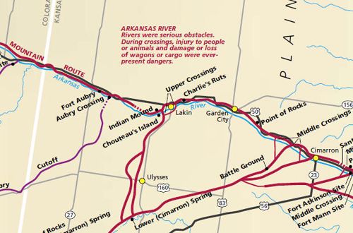
From Ford County, the trail continued into Gray County along the north side of the Arkansas River. The Middle Crossings of the Arkansas River to the Cimarron River extended from the Caches site, about two miles west of Dodge City, to Charleston, 26 miles farther west. US Highway 50 along the Arkansas River closely follows the trail route and passes by the crossing sites.

Cimarron Crossing Park, Cimarron, Kansas.
Due to its shallow flows, wagons could cross the Arkansas River virtually anywhere in this region. The Middle Crossings were the scenes of numerous Indian attacks during the Trail era.
The trail passed through Cimarron, Kansas, providing another branch to the shorter Cimarron Route to Santa Fe. Here was another popular crossing of the Arkansas River and several more on the path to Ingalls, Kansas. A marker designates this crossing in Cimarron Crossing Park about 1/2 mile south of Cimarron, Kansas, on K-23.
The Mountain Branch of the trail continued westward, following the Arkansas River near present-day US Highway 50, to Ingalls, where there was another river crossing.
©Kathy Alexander/Legends of America, updated May 2025.


West to Finney County
Also See:
Cimarron Branch Through Western Kansas
Kansas Santa Fe Trail Photo Gallery
Santa Fe Trail – Pathway to the Southwest
Sources: See Santa Fe Trail Site Map & Writing Credits