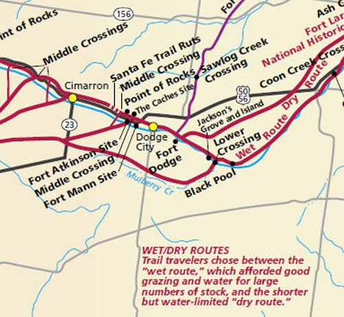
Santa Fe Trail through Edwards and Ford Counties, Kansas.
Both the wet and dry routes of the Santa Fe Trail continued into Ford County, Kansas, with the Wet Route following the north side of the Arkansas River, while the Dry Route entered the county about eight miles north of the river. These two lines came together near Ford County and then followed along the north side of the Arkansas River, through the present site of Dodge City and near the “Caches” five miles west, before entering Gray County just north of the Arkansas River. The Cimarron Route also began in Ford County, branching off at the Lower Crossing of the Arkansas River near the mouth of Mulberry Creek, following up the creek, and running to the southwest.
Wet Route (Mountain Branch) in Ford County
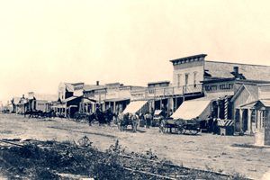
Dodge City, Kansas, about 1875
As the path continues into Ford County, it reaches the “Black Pool” about four miles east of present-day Ford, Kansas. The Black Pool is a spring so named because the water appears black when viewed from above, due to an underlying shale shelf. Many inscriptions have been left on the rock ledge above the pool, and well-defined trail ruts can be seen nearby. The pool is located one mile north on Kansas 154, across the Arkansas River, 3.5 miles east on the first gravel road, and then 0.5 mile south to a pasture.
The trail then continued to the Lower Crossing of the Arkansas River, also referred to as the Point of Inception. This was the site where the Wet Route of the Santa Fe Trail departed to ford Mulberry Creek and continued toward Santa Fe on what was known as the Cimarron Route. This route ran through the Cimarron Desert, or La Jornada (the Journey), because there was almost no water. The Lower Crossing was not used much after the 1830s. The Lower Crossing is near where Kansas Highway 154 crosses the river, about one mile north of Ford, Kansas.
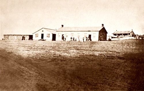
Vintage Fort Dodge, Kansas
Continuing towards Fort Dodge and Dodge City, Kansas, the path came to Jackson’s Island on the Arkansas River. Not really an island; it was actually a peninsula covered with a large stand of timber on the south side of the river.
This “island” developed into a well-known campsite. In 1843, there was a confrontation between Captain Philip St. George Cooke’s dragoons and Colonel Jacob Snively from the Republic of Texas. Snively and his men had come north to raid Mexican Caravans on the Santa Fe Trail, and Cooke and his men disarmed them.
The trail continued to Fort Dodge, established in April 1865, to help protect the Santa Fe Trail. The fort site had been previously used as a campsite by Trail travelers because the wet and dry routes rejoined at this point. A stage station preceded the fort, but Indians later burned it. Fort Dodge troops protected stagecoaches, mail, and railroad construction crews. The fort was decommissioned in 1872 and became the Kansas Soldiers Home, which continues to operate today. Although many of the original buildings have been remodeled, they illustrate army life along the Santa Fe Trail.
Dry Route (Cimarron Branch) in Ford County
The Dry Route into Ford County passed by the Arroyo Blanco campsite, a gully streaked with alkali deposits. In Spanish, Arroyo Blanco means “White Ravine.” It then meandered on to the Little Little Coon Creek Crossing, where multiple ruts can still be found in the area. During the trail days, the stream was known as Little Coon Creek, but the main channel of today is labeled Big Coon Creek. The crossing was used on the Post-1859 Dry Route and as a campsite on the stage company’s route. The Dry Route then continued to the Lower Crossing of the Arkansas River, where it rejoined the Wet Route.
Combined Wet-Dry Route in Ford County
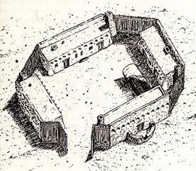
Fort Mann, Kansas.
The path then led to Dodge City before passing Fort Mann, established in April 1847. The Army needed a post midway between Fort Leavenworth and Santa Fe to repair wagons and replace animals. Though not a military post, Fort Mann was defensible and occasionally occupied by regular troops. It was abandoned in 1848. The old Fort Mann site is located about one mile west of Dodge City on U.S. Highway 50.
The old site of Fort Atkinson is located just about another mile further. It was established in 1850 to control Indians and protect the Santa Fe Trail. In 1851, a newly built fort was officially designated as Fort Atkinson and was the first fully garrisoned fort erected along the Santa Fe Trail. Its mission was to protect the Trail from Indian raids. It was unsuccessful and abandoned in October of 1854 due to inadequate buildings and the difficulty and expense of supplying it. The site is about two miles west of Dodge City on U.S. Highway 50.
Just northwest of Fort Atkinson was “The Caches,” a hiding place for trade goods that the Baird/Chambers party stored in 1823.
Santa Fe Trail ruts near Dodge City, Kansas.
About three miles west of Dodge City was a landmark called Point of Rocks, a favorite lookout place on the Santa Fe Trail. Here, there were once four Points of Rock overlooking the trail. In 1915, a marker was placed about five miles west of Dodge City at the highest point, High Rock. However, that point was destroyed by highway construction in 1981. The remaining outcroppings now have a marker three miles west of Dodge City on U.S. Highway 50 on the north side of the road.
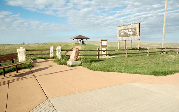
Nine miles west of Dodge City is an excellent set of trail ruts on the north side of Highway 50. It is owned and managed by the Boot Hill Museum, which permits visitors to walk to the site of the parallel ruts. The Kansas Highway Department has provided a turnout and a parking area.
©Kathy Alexander/Legends of America, updated November 2025.


West to Gray County
Also See:
Kansas Santa Fe Trail Photo Gallery
Santa Fe Trail – Pathway to the Southwest
See Sources.