
Starvation Peak, also known as Bernal Hill, is just south of Bernal, New Mexico, by Kathy Alexander.
Sitting in the shadow of Starvation Peak, Los Cerritos de Bernal got its start in November 1794 when Lorenzo Marquez, for himself and on behalf of 51 other Santa Fe families, asked Spanish Governor Fernando Chacón to make them a grant of lands at a place called El Vado, and the surrounding area. The San Miguel del Vado Land Grant of 315,000 acres was approved, and several new communities, including Bernal, were established in the Pecos River Valley.
The village is located on the west bank of Bernal Creek, on the south side of I-25, at exit 330.
Bernal was busy with traffic during its Santa Fe Trail days, and the imposing 7,031-foot tall butte, alternately called Bernal Hill and Starvation Peak, located just south of the town, was a significant landmark for people traveling along the Santa Fe Trail. At its base was Bernal Springs, which served as a campsite and a stage stop along the old trail
In 1855, Major William Anderson Thornton, a member of a military expedition from St. Louis, Missouri, to New Mexico, described the peak in his diary of August 25th:
“En route [From Las Vegas to Santa Fe] we passed about 7 miles from San Miguel, the San Barnard Mountains [Bernal Hill] about 1500 feet high. It rises with a rapid slope for about 1400 feet and then terminates with a perpendicular overhanging top resembling a stupendous castle set high in the air neatly roofed. I could not bewish that the stars and stripes were wavering from its top. General Kearny strove to place a flag on it when he marched around its foot during the war with Mexico, but he found it an impossible job. The villages, grounds, soil, productions, herds, and c. as before named, but the scenery even hourly becoming more grand and beautiful.”

An old building in Bernal, New Mexico.
There is a legend to the name of “Starvation Peak,” which says that a group of hostile Indians drove some 36 people to the top of this mesa during the Spanish colonial period, where they were either killed or died of thirst and starvation. A traveling reporter documented this story in an 1884 edition of the Detroit Free Press. Over the years, the story “grew,” by 1939, when writers from the Works Progress Administration were documenting the region, the number of colonists had grown to 120. Though no evidence supports this tale, the butte has been called Starvation Peak for well over a century.
Despite this early traffic along the Santa Fe Trail, Bernal appears to have never grown very big. Making matters worse, when the Atchison, Topeka, and Santa Fe Railroad laid its tracks through the region in the early 1880s, it built its station 1.5 miles east of Bernal. The station was first called Bernal but was later renamed Chapelle. Another small community called Chapelle grew around the train station.
Bernal had a post office intermittently between 1881 and 1895.
The Capia de Santa Rita de Cascia (Santa Rita Chapel) was built of stone in 1916. It continues to serve a congregation today. It and the Bernal Store are the only buildings in Bernal, except for a few houses.
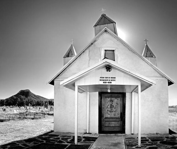
Santa Rita Chapel in Bernal, New Mexico, by Mark Goebel, Saatchi Art.
In 1926, Route 66 came through the community but was rerouted in 1937.
Sections of the Santa Fe Trail probably ran due west of Starvation Peak to San Miguel del Vado, a major stop on the trail. However, today’s traveler must return to I-25, travel seven miles west to Exit 323, and then travel 2.4 miles south on New Mexico Highway 3 through the village of Ribera to reach the San Miguel Del Vado National Historic District.
In its short life through the region, Route 66 did not pass through San Miguel Del Vado; instead, it made a direct path from Bernal to San Jose some ten miles west of Bernal along I-25.
©Kathy Alexander/Legends of America, updated March 2025.
Also See:
Santa Fe Trail – Highway to the Southwest
Sources:
Hinkley, Jim; Route 66 Encylopedia, Voyageur Press, 2016
San Miguel del Bado Land Grant
Work Progress Administration, New Mexico A Guide To The Colorful State, 1940


