
Turquoise Trail National Scenic Byway map courtesy Turquoise Trail Association.
Nestled in the hills and valleys of central New Mexico is one of the state’s most interesting and scenic drives – the Turquoise Trail National Scenic Byway. This often-forgotten road is filled with history, scenic views, ghost towns, a National Forest, a ski resort, art galleries, shops, museums, and more.
Linking New Mexico’s two most significant cities – Santa Fe and Albuquerque, the 65-mile national scenic byway is often called the back road between the two cities. Named for the rich turquoise deposits found near its northern end, the Turquoise Trail was used for centuries by Native Americans and Spanish explorers before miners began to flood the area in the late 1800s in search of the hills’ many rich minerals. The beautiful blue-green turquoise was first mined by the early Pueblo people as early as 900 A.D. Though this hilly highway has seen much recent growth, it still maintains a historic view of the Old West and its galleries, restaurants, and museums.
Tijeras
The scenic byway begins in Tijeras, about 16 miles east of Albuquerque. In Tijeras is one of the Cibola National Forest’s Visitor Centers, which provides numerous brochures and information about the area. The forest spans three states and almost 2 million acres. Also, the Tijeras Pueblo Ruin site was formed about 1300 A.D. This canyon community eventually housed about 400 Indians; however, major droughts drove them out. Today, the 200-room pueblo is a grass-covered mound and a frequent site for archeological excavations. This small town was once one of the many communities on old Route 66 and is also home to the world’s longest tramway, where visitors can ride almost three miles to see spectacular views of the Sandia Crest Highway, Albuquerque, and the Cibola National Forest.
During the summer and into the fall, from May through October, Tijeras also offers a juried arts and crafts market at 488 E Highway 66. This market provides not only the work of some of New Mexico’s finest artisans but also live music and a beautiful scenic setting.
Cedar Crest
From Tijeras, the route follows NM-14 through Cedar Crest. This small, mostly residential community is home to the Museum of Archaeology and Material Culture, which explores the 12,000-year story of Native American History. The Turquoise Trail visitor can also find a number of shops and restaurants.
Sandia Park
Just up the road, you will arrive at Sandia Park. You will find outdoor activities here, from skiing at the Sandia Peak Ski Area to hiking, horseback riding, climbing, and more. Another Scenic Byway is also presented here – the Sandia Crest Highway, just 13 short miles on NM 536, which winds through the Cibola National Forest and provides impressive scenic views. On this highway, visitors can ride the Sandia Peak Tramway and visit the Tinkertown Museum, which provides an animated miniature Old West town, circus relics, and thousands of hand-carved figures.
Golden

San Francisco Church in Golden, New Mexico.
Continuing on the Turquoise Trail, another ten miles brings you to its first ghost town – Golden, established in 1879 when gold was found there. Soon, prospectors crawled all over the area, but less than a decade later, the gold was gone, and the town began to die. Ranching continues in the area dotted with the ghost town’s crumbling remains, as well as traces of two pueblos that date back to 1300 A.D. The San Francisco Catholic Church, built in 1830, is one of the most photographed buildings along the Trail. Historian and author Fray Angelico Chavez restored this beautiful little adobe church during his tenure as padre of the San Jose in Cerrillos in the 1960s.
While here, don’t miss the general store, which has been operating since 1918, before moving on towards Madrid.
Madrid

Madrid, New Mexico, by Kathy Alexander.
Twelve miles later, the trail takes you through Madrid, categorized as a ghost town despite having some 300 residents. It thrives in the summer with shops, restaurants, and galleries catering to the many visitors along this ancient path.
Madrid and neighboring Cerrillos have long been known for the turquoise nestled in the surrounding hills. Mined by the Indians for centuries, it was later discovered by Spaniards, who also searched the area for silver and gold. In the early 1800s, American prospectors moved into the area, and in the 1880s, large coal mine companies began operations.

Old Company House, Madrid, New Mexico, by Kathy Alexander.
Madrid boasted more than 3,000 residents and produced some 250,000 tons of coal a year during the peak of the coal mining industry.
But Madrid’s boom was not to last. As natural gas became the more popular fuel for home heating, the demand for coal began to fall.
The town of Madrid collapsed along with the coal market. In 1954, the Albuquerque and Cerrillos Coal Company ceased operating, and almost all its residents moved away.
However, by the early 1970s, several artists, craftsmen, and other individuals wanting to make their homes in the mountains began to move into the area, and Madrid was reborn. Today, this unique and picturesque small town is a haven for day-trippers and travelers along the historic Turquoise Trail Scenic Byway as they browse its many shops, cafes, and bed and breakfast inns.
Los Cerrillos
Before long, you will arrive at Los Cerrillos, best known for its beautiful blue-green turquoise, which was mined in the Cerrillos Hills as early as 900 A.D. One of the oldest historically documented mining districts in the United States, this almost “ghost town” is a must-stop along the Turquoise Trail.
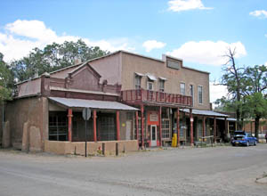
The old Simoni Store and Wortley Hotel on Front Street in Los Cerrillos, New Mexico, by Kathy Alexander.
Beginning with Native American miners followed by the Spaniards, the area boomed in the 1880s when gold, silver, and lead mines began to operate in the area. In no town, the population of Los Cerillos had grown to over 2,000 souls who supported four hotels, 21 saloons, and numerous other businesses. Like many other boom towns, Los Cerrillos played out when the minerals were gone. However, the town has made a partial rebirth as numerous people find this historic Old West settlement and its many sites, including the Los Cerillos Historic Park, adobe homes and businesses, Saint Joseph’s Church, a museum, and more.
Beyond Los Cerrillos, the trail continues to meander through the Galisteo Basin, which once supported a very large Pueblo population in 1300 A.D. The area, known for its razor-back rock formations called “Garden of the Gods,” is home to the Eaves Movie Ranch, where over 100 movies have been filmed.
Just north of Lone Butte/San Marcos, travelers reach the end of the Trail, where it meets historic Route 66 and Santa Fe.
Contact Information:
Turquoise Trail Association
888-263-0003
© Kathy Alexander/Legends of America, updated July 2024.
Also See:
Golden, New Mexico Has Seen Better Days
Los Cerrillos – 2,000 Years of History
New Mexico – Land of Enchantment
See Sources.