
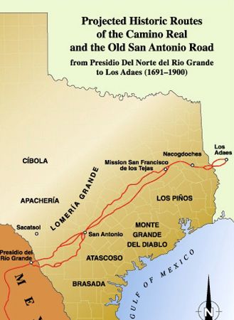
Old San Antonio Road Map.
During the Spanish colonial period in America, the Spanish established several royal roads that connected far-flung regions to Mexico City. One of these was El Camino Real de Los Tejas, also called the Royal Road, the King’s Highway, the Old San Antonio Road, and the San Antonio-Nacogdoches Road. The ever-changing 1,000-mile trail provided the only primary overland route from Mexico City across the Río Grande to Los Adaes, the first capital of the Texas province in present-day northwestern Louisiana. The Spanish also established other Caminos Reales, including the mission trail up the coast of California and the road from El Paso, Texas, to Santa Fe and Taos, New Mexico, known as the El Camino Real de Tierra Adentro.
Not every route the Spanish used during their exploration and settlement of New Spain met the designation requirements of a Camino Real. Caminos Reales connected economically significant Spanish towns, provincial capitals, and mines with charters that conferred royal privileges.
Following established Indian trails and trade routes, it was first blazed by several Spanish expeditions in the late 17th Century to connect a series of Spanish missions and posts. It was also developed to confront and counter French and English intrusion into the northeastern frontier of the Spanish borderlands. Settlements along the road became some of the state’s earliest cities and communities.

Spanish Conquistador.
The blazing of the trail resulted from three expeditions. In 1690, Alonso De Leon led his fourth expedition into Texas to establish the short-lived San Francisco de Los Tejas Mission in present-day Houston County. The following year, Domingo Teran de Los Ríos, the first provincial governor of Texas, crossed the Rio Grande and took additional missionaries to the East Texas missions. Following much of the same route as De Leon, Teran diverted to send a party to Matagorda Bay to meet supply ships. In 1693, Gregorio de Salinas Varona traveled directly from the Rio Grande to the East Texas missions, further defining the route as a direct line.
Though sometimes thought of as a single road, the El Camino Real de Los Tejas is better described as a network of trails, with different routes used at different times. Numerous feeders branched off the main course. Other segments didn’t appear until much later, with the trails coming together at San Antonio and Nacogdoches, the only two population centers in those early days. The trail also shifted because of flooding and Indian threats.
The route between the Rio Grande and San Antonio gradually shifted southeastward over time due to the Apache and Comanche tribes‘ threats. Initially, Spaniards used it primarily to move northeast, serving as a lifeline for the missions, a trade route, and a cattle trail. However, by the 1820s, numerous Anglo immigrants began using the trail from Nacogdoches to new settlements farther West. In 1820, Moses Austin traveled the trail to San Antonio to request an empresario grant from the Spanish government. Many Anglo-American colonists entered Texas at Gaines Ferry on the Sabine River, then moved to Nacogdoches and the interior of Texas. These roads were used for travel and formed some of the earliest political boundaries, such as separating land grants and becoming county lines.
The El Camino Real de Los Tejas provided access for armies on the move, including Spanish, French, Mexican, Republic of Texas, and American forces, and helped determine the southern and western boundaries of the United States and Mexico. Thousands of American immigrants arrived in Texas via a section of the Camino Real known as the San Antonio Road. Their presence and activities led to the revolt against Mexico, Texas’ independence, and eventual statehood.
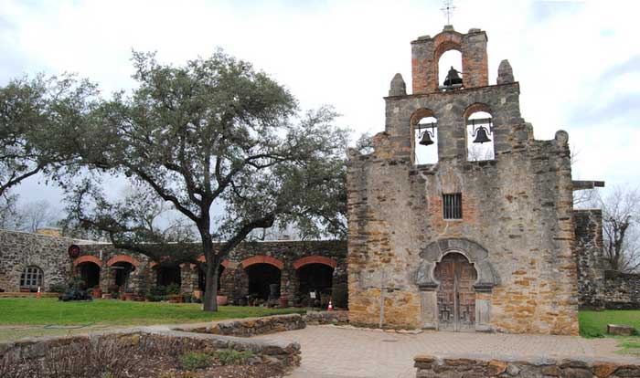
Mission San Francisco de la Espada, the southernmost of the San Antonio missions, by Kathy Alexander.
As the only primary overland route from the Río Grande to the Red River Valley for more than 150 years, the trail served as a conduit for exploration, trade, migration, settlement, and change. Connecting cultural and linguistic groups, the pathway blended Spanish and Mexican traditions, laws, and cultures with those of Anglo-Americans, creating a rich legacy reflected in the people, places, music, and arts of Texas and Louisiana today.
After Texas’ independence, the road fell into disuse as the emphasis shifted to north-south routes. Courses were shifted to accommodate new settlements and markets, providing access to coastal trade. Shortly after the Mexican-American War, the Old San Antonio Road regained some of its former importance as potential prospectors flocked westward during the California Gold Rush.
Later, during the Civil War, the road served as a major route for troops and supplies. After the war, large segments of the route were abandoned in favor of newer, shorter roads that linked Texas’ growing cities. In the latter part of the 19th Century, as railroads expanded through Texas, almost all roads were abandoned, except for local transportation. However, later highways followed similar paths, including I-20, U.S. Highway 59, and Texas Highway 21.
In 1915, the Texas Legislature appropriated $5,000 to survey the Old San Antonio Road through Texas, and the Daughters of the American Revolution soon erected pink granite markers along the old trail. In 1991, on the 300th anniversary of the old road, the Old San Antonio Road Preservation Commission was formed to study the historical and archeological evidence along the old route.
In 2004, Texas Senator Kay Bailey Hutchison persuaded Congress to designate El Camino Real de Los Tejas in Texas and Louisiana as a national historic corridor. The path runs from Mission San Juan Bautista, Guerrero, Coahuila, Mexico, to Fort St. Jean Baptiste in Natchitoches Parish, Louisiana. Today, the National Park Service administers El Camino Real de los Tejas with other federal, state, and local agencies, as well as non-profit organizations and private landowners.
More Information:
El Camino Real de los Tejas
PO Box 728
Santa Fe, New Mexico 87504-0728
505-988-6098
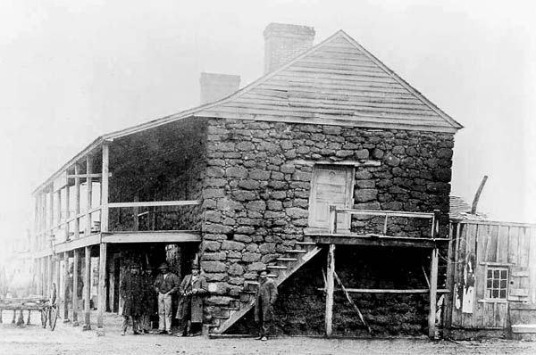
Old Stone Fort, Nacogdoches, 1885.
©Kathy Alexander/Legends of America, updated October 2026.