
An old ore wagon sits near the entrance of Sugarite Canyon State Park near Raton, New Mexico. Photo by Kathy Alexander.
Sugarite Canyon State Park is located on the Colorado–New Mexico state line six miles northeast of Raton, New Mexico. It is part of the Dry Cimarron Scenic Byway, which travels from Raton across Johnson Mesa to western Oklahoma.
Sugarite Canyon (pronounced “shug-ur-eet”) is a sparsely populated region consisting of a stream valley flanked by cliffs, mesas, cone-shaped volcanoes, and old lava flows. The 3,600-acre park is about four miles long and 1.5 miles wide and includes the ruins of the abandoned Sugurite coal mining camp, Lake Maloya, and Lake Alice, both of which are stocked with rainbow and brown trout.
Sugarite is believed to be the anglicized version of Chicorica, the canyon and adjacent mesa’s original name. Long before this beautiful canyon became a coal camp, it was called home to several Native American tribes, including the Comanche, Ute, and Apache, who hunted here for centuries. The canyon was active with cattle ranches in the late 1800s.
Later, Spanish explorers, mountain men, trappers, and traders traveled through the canyon as an alternative to Raton Pass. This area became part of the Maxwell Land Grant, awarded initially to Guadalupe Miranda and Charles Beaubien in 1841.
Sugarite, New Mexico Coal Camp
Coal mining in the canyon began in 1894 and was first developed by the Chicorica Coal Company, which opened the Hartsell and Meredith Mines. The Raton Fuel Company opened the Sugarite No. 1 and 2 mines in 1901 and 1902.
In the early days, miners relied on mules and burros to pull coal-filled carts from the underground mines to the surface. The coal was then hauled by wagon seven miles to Raton. The Santa Fe, Raton, and Eastern Railroad initially constructed a railroad line in 1905 to Lake Alice. However, it was cut back to the town of Sugarite in 1911. For decades, the railroad ran from the Sugarite and Yankee mining camps to Raton nearly daily.
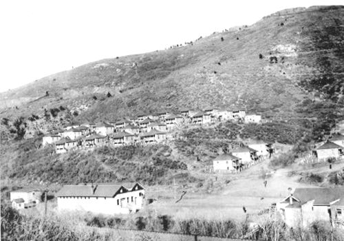
The St. Louis, Rocky Mountain, and Pacific Company took over the coal mines in 1912, quickly ramping up full-scale mining operations. The post office was established the same year, and the “company town” of Sugarite was quickly developed—an orderly town of sturdy blockhouses perched upon canyon slopes.

Sugarite, New Mexico, during its busy coal mining days.
The first school opened in a four-room house. Later, a new two-room school was constructed, containing a large auditorium upstairs used for dances, motion pictures, and other social events. The town also had a theater, the Blossburg Mercantile Company, the Bell Telephone Company, an opera house, a boarding house, a physician, a justice of the peace, and a music teacher. A clubhouse served as the center of activity during the cold winter months. Movies were shown there twice a week, the Goldenrod Club sponsored cultural programs, and the center had a soft drink bar and pool room. Church services were also held there. At one point, it was said to have had a population of nearly 1,000 residents, many of whom hailed from Eastern Europe, Italy, Greece, Scotland, Wales, Ireland, Mexico, and even Japan.
Sugarite’s population fluctuated between 100 and 200 residents from season to season and year to year, but in 1915, it reported about 500 people.
After more than four decades of coal mining, which amounted to 562,497 tons, the mines began to shut down in 1941. At that time, 450 people were living in the community. The railroad and the post office were closed in 1944. Afterward, many homes and buildings were moved to Raton, and others were razed.

Ruins of the old Sugarite School House, by Kathy Alexander.
Sugarite Canyon State Park was established in 1985 and now receives about 125,000 visitors annually.
The Sugarite Coal Camp’s remains are at the park entrance, including a couple of old buildings and numerous rock foundations. Amazingly, given its size, there is little left of the town of Sugarite other than low walls and foundations. This was not uncommon at the time, as “company towns” were often moved — lock, stock, and barrel to the “next” mining camp or were sold off for salvage. However, a glimpse at the miners’ lives can be seen if you take a scenic hike through the ruins, which include numerous foundations along the interpretive trail. The visitor’s center is located in the old post office. A short distance north of the post office is a stone barn and a house, now utilized by the State Park and Recreation Division as a shop, warehouse, and park manager’s residence. The 40-stall barn once housed mules that were used in the coal mines.
In addition to its history as a coal mining area, nature enthusiasts will appreciate the abundance of wildlife, birds, butterflies, and wildflowers among the lakes, creeks, forests, and meadows. Several outdoor recreation activities are possible, including fishing, boating, hiking, horseback riding, hunting, and camping.
More Information:
Sugarite Canyon State Park
HCR 63, Box 386
Raton, New Mexico 87740
575-445-5607

Deer in Sugarite Canyon, New Mexico.
©Kathy Alexander/Legends of America, updated March 2025.
Also See:
Byways & Historic Trails – Great Drives in America
Coal Mining Towns of the Vermejo Park Ranch
Sources:
New Mexico Bureau of Geology & Minerals
Sherman, James & Barbara; Ghost Towns and Mining Camps of New Mexico, University of Oklahoma Press, 1975
Sugarite Canyon State Park