
Route 66 in Calumet, Oklahoma by Kathy Alexander.
Heading west from El Reno, Oklahoma, on Route 66, this earliest alignment (1926-1934) of the Mother Road travels through several small towns that show the obvious suffering that results from superhighways bypassing small towns. The first three, Calumet, Geary, and Bridgeport, were cut off early in the Mother Road’s history when the El Reno bypass took them off the route in 1934.
Calumet, located in northwestern Canadian County, is about 13 miles northwest of El Reno on Highway 270.
The Cheyenne and Arapaho Indians first permanently settled this land until the Organic Act of 1890 organized the Oklahoma Territory from land formerly ceded to Indian Nations. After the reservation lands were split up and 160 acres were assigned to individual tribe members, the government purchased the surplus. It opened to settlement during the “Cheyenne-Arapaho Opening” in April 1892.
In 1898, Reuben G. Shirk platted ten acres of his farm for a townsite in response to the Choctaw, Oklahoma, and Gulf Railroad’s decision to construct a depot in the area. Calumet is a variant term for the Native American ceremonial pipe.

Choctaw, Oklahoma, and Gulf Railroad.
The Calumet post office was established in 1893 by Anna Cowdrey on her homestead about two and a half miles southwest of the town, and then moved to the new community.
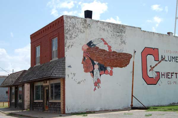
In 1901, Calumet claimed a population of around 100, but shortly after Oklahoma became a state in 1907, the town had almost 300 residents. In 1908, it gained its first newspaper — the Calumet Chieftain, which served as the town’s newspaper until 1942. By 1911, the agricultural community had three combination mills and elevators, two general stores, a furniture store, and a hardware store.
In 1926, the first original alignment of Route 66 was constructed through Calumet. It looped north from El Reno through Calumet and Geary before going south through Bridgeport. This brought more people to the area; by the end of the 1920s, the Calcument’s population was 451, making it one of the larger towns in Canadian County.
Calumet, Oklahoma Buildings by Kathy Alexander.
However, this transportation boom was short-lived. In 1933, a new Pony Bridge was built across the Canadian River downriver from Bridgeport. The following year, Route 66 was realigned directly from El Reno to Hydro, bypassing Calumet, Geary, and Bridgeport. By 1940, the population had fallen to about 300 people. In 1942, the town was incorporated to construct a city water system.
In the 1970s and early 1980s, Calumet economically benefited from the growth in area oil and gas fields and the continued prosperity of local farms. While the oil and gas market collapsed in the mid-1980s, agriculture-related businesses continued to do well.
Today, this small town is home to about 600 people and has one school building that serves all grades. Old Route 66, which runs right through the center of town, still provides a peek at its vintage past, with several murals painted on its buildings.
Continue the journey of this old alignment to nearby Geary, Oklahoma, just 11 miles distant.
©Kathy Alexander/Legends of America, updated March 2025.
Also See:
Sources:


