By Pat Edwards and Jo-Brew
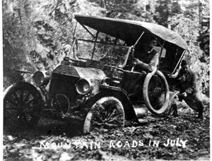
Mountain Roads in July, vintage postcard courtesy of Curtis Irish.
In the early part of the 20th century, travel through and between the Pacific Coast states of Washington, Oregon, and California was cumbersome. Towns and developing cities were haphazardly connected, and, for the most part, the roads were still dirt trails wending through all kinds of terrain. In the fall and winter months, after the rains began, especially in the Pacific Northwest, these tracks became muddy quagmires that even horses, mules, and wagons had trouble navigating. To the dismay of small-town residents, the newfangled machines called automobiles that Henry Ford and his colleagues began building were beginning to appear and gain popularity. Unfortunately, they were frequently jacked up on blocks and stored away during the wet autumns, winters, and springs when the roads became impassable.
As the love affair with the automobile began to take hold, more and more people began petitioning for a main highway that would not only run through the whole State of Oregon from north to south but also connect it to its neighbors in Washington and California. The same movement was happening in those states, too, and the dream to join the whole West Coast gained momentum.
In 1913, Oregon Governor Oswald West turned the first shovelful of dirt on the Siskiyou Pass to mark the beginning of the construction of that long-dreamed-of Pacific Highway through Oregon. At the time, the whole State of Oregon had only 25 miles of paved road. Even after the construction of the highway began, it was mainly dirt and gravel for quite some time. Federal money did not pour into the project until 1921. Until then, it was up to the counties along the route to raise the funds to build roads through their areas. By its completion in 1926, however, it was adopted as U.S. Highway 99 and was declared the longest-improved highway in the country by 1928.
 The route of the Pacific Highway, later known as U.S. Highway 99, had its beginnings long before the gold rush and westward expansion of white settlers. The Native American tribes roamed throughout the area for centuries, establishing their own routes to winter and summer lodgings and areas where fish and game were plentiful and their favorite plants – camas roots, acorns, hazelnuts, fruits, and berries – could readily be found during their seasons of harvest. Most of those original routes followed animal trails. For centuries, the migrating herds of deer and elk had found the most expedient way to traverse the mountains and valleys.
Once the French Canadian fur traders of the Hudson’s Bay Company, the gold miners, and, eventually, the white settlers arrived, they also used many of the Indian trails to find the easiest routes for their wagons and horses.
These early trails eventually became stagecoach roads as the need to transport settlers, commodities, and mail from one locale to another grew.
As part of the Pacific Railway Act of 1862, later modified in 1866, the federal government began offering land grants to the California and Oregon Railroad of California and to a company designated by the Oregon Legislature to build a railroad line connecting California and Oregon. When completed in 1887, the railroad provided most of the shipping and passenger travel between Washington and California via Oregon’s interior. However, steamships on the Willamette River continued to operate until U.S. Highway 99 was developed and improved.
With the advent of the automobile, more and more families began to avail themselves of the growing system of roads and highways. Bus lines – most notably Pacific Greyhound Lines – began providing transportation for those who did not own automobiles. Soon, Greyhound and, to a lesser extent, Trailways Bus Lines began providing parcel post service between towns along their routes.
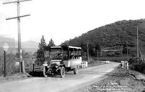
Motor Bus on Pacific Highway between Ashland and Medford, 1915. Photo courtesy of the Talent, Oregon Historical Society.
The railroads began cutting down on passenger service, and automobile-related businesses began blossoming along U.S. Highway 99. Gas stations, auto courts/motels, and other businesses began appearing. Towns along the routes began to grow and prosper. Many of the “Main Streets” were U.S. Highway 99. There were instances in which the business districts of entire towns were changed to accommodate the tourist and commercial traffic generated by the highway.
During the mid-1920s and 1930s, when the airplane first became an obsession with the public, distance and endurance records were constantly being reset, and Charles Lindbergh was the national hero, the Richfield Oil Company of California developed an advertising scheme called the “Lane of Light.” It not only provided a valuable service to automobile drivers but also to private pilots. At that time, it was common practice for pilots of those early planes to follow highways and railroad lines, using them as their primary means of navigation. The noses of the early planes were so long that the pilots could not see over them, so it was necessary to look down over the side door. Radar and guidance systems were a thing of the future, so they had to “fly by the seat of their pants.” U.S. Highway 99 became the central aviation flyway in Oregon during this time.
The gas stations were spaced less than 100 miles apart along U.S. Highway 99, so automobile drivers would be approaching the next station when their fuel gauges were nearing empty.
 Near each building, a 125-foot steel tower was assembled. It had a beacon on top, and neon letters placed on one side of the tower spelled “Richfield;” on the opposite side was the name of the nearest town where it was located. Some of the properties had airfields for small planes to land, and hotels were planned for others… some had both. The company planned to make these sites a small community in themselves. Richfield owned them, but generally, they did not operate them. In most cases, they were leased to local businessmen.
The Norman-style buildings were comfortable and luxurious, with “lounging rooms” for men in one wing and for women in another. They each had a salesroom and a canopy over the gas pumps. The grounds around them were landscaped to attract business.
Unfortunately, the Great Depression sent the Richfield Company’s division into receivership, and many stations were closed or put to other uses.
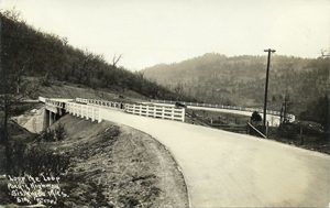
The ‘Loop the Loop’ section of the Pacific Highway in the Siskiyou Mountains south of Ashland. Photo courtesy of OSU Special Collections & Archives, Gerald W. Williams Collection.
The highway itself, beginning at the California border, traverses the majestic snow-covered Siskiyou Pass as it winds into the cultural town of Ashland, Oregon, which hosts its very popular Shakespearean Festival each year.
As the highway heads north, it enters the Rogue River Valley, which is known not only for its extremely popular fishing and recreation sites along the beautiful Rogue River that was immortalized by Zane Grey and frequented by the likes of Jack London, Ginger Rogers, U.S. Presidents, but for its vast orchards and agricultural bounty, as well. The larger Southern Oregon cities of Medford and Grants Pass lie in this area.
After leaving the Valley of the Rogue, it enters the heavily forested southern end of the Umpqua Valley. Surrounded by steep, rocky terrain and the vast Umpqua National Forest, there were not many options for routing U.S. Highway 99 other than through Canyonville, which is steeped in the Native American history of the Cow Creek Tribe.
As the highway passes northward, the Umpqua Valley broadens, and the rolling green hills, dotted with oak and hardwood trees, offer a different flavor of Oregon. In this section, many ranches raise cattle and sheep, and as the traveler travels farther, they will see more signs indicating they are entering wine country. Douglas County’s largest city and County Seat is in Roseburg, which, in 1959, lost 14 lives and many city blocks of its downtown area when a dynamite truck exploded. The city’s downtown retail core was literally destroyed.
Traveling further north, as one nears the Eugene/Springfield area from the south, the highway passes through major forests of Douglas Fir and gold mines in the Bohemia Mining District near Cottage Grove. It then makes the rest of the journey to the Washington border by following the mighty Willamette River, which turns north after flowing from the Cascade Range to the east. The vast Willamette Valley hosts Oregon’s largest cities and some of its smallest towns.
The original route of U.S. Highway 99 took motorists along the east side of the Willamette River, but there were few places to cross to the west. Soon, those living on the west side began petitioning for a western route, and in about 1930, the highway split at Junction City and joined with “Highway 3,” becoming U.S. Highway 99W.
The highway takes you through huge grass seed and grain production acreages, which also host large herds of sheep during the fall and winter months. Further north, on the east side, is the French Prairie area, which produces much of the state’s crops. The west side, running through Corvallis, McMinnville, and into Portland, is a central wine-producing region.
U.S. Highway 99’s east and west routes join in Oregon’s largest city, Portland, a short way south from the Interstate Bridge over the Columbia River into Washington.
U.S. Highway 99 was indeed “Oregon’s Main Street” from 1923 until it was decommissioned in 1966 after the completion of Interstate 5.
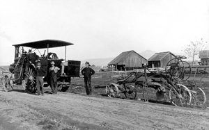
A road crew upgrading the Pacific Highway near Talent, OR. Photo courtesy of the Talent Historical Society.
Our two books, OREGON’S MAIN STREET: U.S. Highway 99 “The Stories” and “The Folk History,” are meant to give you an idea of what life was like and what it was like to grow up in the communities that lie along its path.
Join us on our journey through these communities as we wend our way north from the California border, where the Pacific Highway first started from that shovelful of dirt. You’ll learn about some interesting yet lesser-known aspects of their histories and the people who were instrumental in shaping them into what they are today.
Sit back and enjoy your trip through Oregon’s heartland. You may decide you want to get in your car and follow the original route of the old Pacific Highway, visiting some of the remarkable communities and sites along the way. Get off the Interstate 5 freeway for a while, and you will discover a whole, not-so-new Oregon that awaits rediscovery.
©Jo-Brew, Pat Edwards for Legends of America – Submitted December 2014. Updated November 2025.
*Special note: These books are offered through Amazon separately; however, if you would like to purchase both and save on some postage, contact Pat Edwards at Groundwaters Publishing.
More about the books:
“The Stories” takes us along the route through Oregon today. It is filled with the stories of those who grew up, worked, played, and raised their families in the communities along U.S. Highway 99. Over 150 individuals shared their stories, some in the form of old letters and diaries, and most in first-person accounts through interviews, letters, emails, and even phone calls, all personally conducted by Jo-Brew.
“The Folk History” covers how the route for the Pacific Highway was determined through its use by trappers, miners, stage lines, and the railroad. Just as important, it will show how each settlement along its route was formed and grew into prosperous cities, small rural communities, and some that are now considered ghost towns.

Author Jo Brew
About the Authors: Jo-Brew (1931-2018) is the author of OREGON’S MAIN STREET: U.S. Highway 99 “The Stories” and co-author, with Pat Edwards, of “The Folk History“.” In addition, she has written six novels. These include Preserving Cleo, Cleo’s Slow Dance, Finding Clarice, and What Next, Ms. Elliott? Marge, Back on Track, Anne Marie’s New Melody, and La Femme, a collection of short stories. She decided that she was ready to leave fiction behind, so she embarked on a new road, drawing on her interest in Oregon and its history, which led to the publication of the two Highway 99 books.
Jo was also an active member of the Association of University Women and, for seven years, wrote a weekly column for the Creswell Chronicle. “When I’m not writing, thinking about writing, or talking about writing, I garden, keep a house, and spend time with my friends. My husband Ken and I both like to travel, and we go whenever we can. We also combine activities with our grown children and their families as often as possible. School concerts, ball games, ultimate frisbee, picnics, and camping are all part of our lives.” Josephine Anne Brew passed away on March 1, 2018.
Author/Editor Pat Edwards.
Pat Edwards is the author of two books about the history of her home community, Lorane, Oregon. The first, Sawdust and Cider: A History of Lorane, Oregon, and the Siuslaw Valley, was written with co-authors Nancy O’Hearn and Marna Hing in 1987 to help celebrate the community’s centennial. In 2006, Pat wrote a major revision of the book called From Sawdust and Cider to Wine. She and her husband, Jim, own the Lorane Family Store, and Pat spent 15 years as an Administrative Coordinator for the Institute of Neuroscience at the University of Oregon.
Since then, Pat has taken on the role of Managing Editor for the literary quarterly Groundwaters, distributed throughout Lane County, Oregon. The magazine is now in its 11th year of publication. Pat is also the community correspondent for two small Lane County weeklies, the Fern Ridge Review and the Creswell Chronicle. Her work with Groundwaters has led her into the field of editing and publishing others’ work. It’s how she and Jo-Brew met. “I’m blessed with a large, loving family. Jim and I celebrated our 50th wedding anniversary in 2014, and our family and home are our highest priorities.”
Also See:
Oregon Trail – Pathway to the West
An Early Sketch of Oregon (historic text)