
Lake Meredith, in Hutchinson County, Texas, is owned by the National Park Service.

Canadian River in Hutchinson County, Texas, by the National Park Service.
Lake Meredith National Recreation Area in Hutchinson County, Texas, lies within the dry and windswept high plains of the Candian River region of the Texas Panhandle. Here is a hidden oasis and welcoming haven where wildlife and people find respite from the dry grasslands above.
The Canadian River has cut dramatic 200-foot canyons through this plain where people have eked out a living for over 13,000 years. The earliest people were nomadic hunter-gatherers who followed the available game and ripening plants. Evidence of their existence has been found throughout the area.
Around 1150 A.D., the Antelope Creek people built homes and quarried Alibates Flint along the Canadian River for 300 years. For thousands of years, people came to the red bluffs above the Canadian River for flint, vital to their existence. Demand for the high-quality, rainbow-hued flint is reflected in the distribution of Alibates Flint through the Great Plains and beyond. The stone-slabbed, multi-room houses built by the Antelope Creek people have long been of interest to the public and studied by archaeologists. The Alibates Flint Quarries National Monument, located within the Lake Meredith National Recreation Area, protects the remains of these ancient people and can only be viewed by ranger-led guided tours, which must be made in advance. It is the only National Monument in the state of Texas.
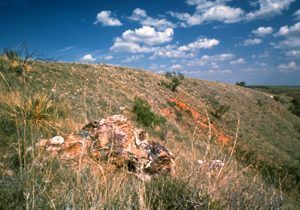
Alibates Flint Quarries, courtesy of National Park Service.
The Antelope Creek people left the Texas Panhandle around 1450 A.D. as the Spanish, who arrived by the mid-1500s, recorded no evidence. Instead, the Spanish, led by Francisco Vazquez de Coronado, encountered bison-hunting nomads whom they called “Querechos.” Modern scholars have identified these people as ancestors of the Apache. Although the Spanish only passed through the area in their futile quest for wealth, their influence was significant because they introduced horses, and Native Americans no longer had to hunt bison on foot.
The Comanche excelled in introducing the horse and quickly became a powerful force. They ruled the plains from the early 1700s until the 1870s. Texas joined the United States in 1845, but the United States Army could not remove the Comanche from the Panhandle until most of the bison had been slaughtered by American hunters. Facing starvation with the near extinction of the bison, the Comanche joined other tribes on reservations in Oklahoma.

Plains Indians.
The forcible removal of the Plains Indians from the Panhandle encouraged pioneers, ranchers, and settlers to head west. Thomas S. Bugbee established the Quarter Circle T Ranch, the second oldest ranch in the Panhandle, in late 1876 along a creek that today bears his name. The following year, the LX Ranch, which included the present-day Alibates Flint Quarries and the surrounding area, was established by W.H. Bates and David T. Beals. In 1897, David N. McBride and his family settled on a section of land in the center of the LX Ranch. The family’s stone ranch house still stands today in what is known as McBride Canyon on the southeastern side of the lake.
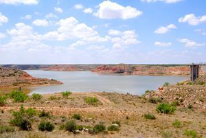
A. A. Meredith, former Borger city manager, devised the project to impound the Canadian River to build Lake Meredith. The federal government built and financed it under the jurisdiction of the Bureau of Reclamation, and the Canadian River Municipal Water Authority owns and operates it. Construction of Sanford Dam began on March 11, 1962, and was completed in 1965.
Unfortunately, A. A. Meredith died of cancer in April 1963, two years before the project’s completion. Initially, Lake Meredith supplied water to eleven West Texas cities and became a popular recreational area. The nearby town of Sanford began to grow, and several resort communities, including Lake Meredith Estates and Bugbee Heights, were established.
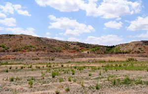
Lake Meredith is down some 78 feet from its peak in 1973 in this photo from 2013 by
Kathy Alexander
The reservoir has been administered by the National Park Service since 1965. In 1972, Sanford Recreation Area, as it was called, was renamed Lake Meredith National Recreation Area.
In April 1973, the lake reached its record-high capacity of almost 102 feet deep and extended into Moore and Potter Counties. Beginning in about 1999, however, drought plagued the Texas Panhandle, and lake levels dropped year after year. In 2011, withdrawals from Lake Meredith for drinking water ceased, and the Harbor Marina and docks were closed and removed. In June 2013, the lake reached its all-time low of 27.03 feet or just 1.3% capacity.
When this writer was a child, we camped at Bugbee Shores on Lake Meredith, which was dry in 2013. The boat ramp is on the other side of the dry lake bed. Kathy Alexander, June 2013.
However, the lake is on the rebound again. Rain has been more plentiful in recent years, and the lake waters have risen. In May 2019, lake levels were at 75.42 feet. Recreation enthusiasts and anglers have returned to what was once one of the most popular in West Texas. In 2025, the lake level was about 76 feet.
The lake still provides hiking, swimming, boating, and camping opportunities amongst the scenic buttes, pinnacles, and red-brown, wind-eroded coves. Lake Meredith is a year-round park. Fall and winter are mild and perfect for outdoor activities like hiking and camping. Spring flowers are beautiful and come in a variety of colors. Summertime heat is just suitable for water sports. Visiting Lake Meredith is free, though boaters must purchase a permit. Many of the campgrounds offer picnic tables and shade shelters. Spring Canyon, which is day-use only, includes picnic tables and fishing and swimming facilities.
Lake Meredith is located about ten miles west of Borger, Texas.
More Information:
Lake Meredith National Recreation Area
P.O. Box 1460
Fritch, Texas 79036
806-857-3151
©Kathy Alexander/Legends of America, updated March 2025.
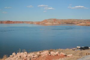
Lake Meredith, Texas, is rebounding today, photo by the National Park Service.
Also See:
Alibates Flint Quarries National Monument
Hutchinson County Photo Gallery
Sources:
Lake Meredith National Recreation Area
Texas State Historical Association