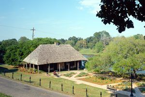
The Cane River region of Louisiana is home to a unique culture: the Creoles. The river shaped the nearly 300-year relationship between the Creoles and their homeland, which was tested by flood, drought, war, and numerous other obstacles. However, the Creoles’ resilience and resourcefulness have allowed the culture to endure and thrive.
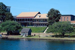
Natchitoches Historic District – National Historic Landmark
In 1690, French explorer Henri de Tonti arrived in the Indian village of Natchitoches. In 1714, three years before New Orleans was founded, another Frenchman, Louis Juchereau de St. Denis, ordered the first substantial dwellings to be built in Natchitoches. This established the first permanent settlement in the vast Louisiana Purchase Territory.
As the settlement grew, active trade with the Spanish began. When Natchitoches became an outpost for the Spanish government in 1764, there was little concern for the colony’s French Creoles. They had been trading with the Spanish since the founding of the city. This became part of the United States in 1803. By this time, Creole planters were building more pretentious structures using traditional “bousillage” construction (a building technique that used wood frame, e.g., upright and angular posts, infilled with Spanish moss and mud). The city of Natchitoches continued to be an important trading and navigation center on the Red River. In 1825, the Red River began changing course and continued to do so until 1849, when the old river channel was abandoned and Cane River Lake was formed. Steamboat traffic to the city was possible only during periods of high water.
The plan for the city was developed from property lines radiating from the river. In the late 1700s, these property lines became streets and were later intersected by other streets, forming rectangular blocks. The area retains the atmosphere of a rural town with well-kept lawns and homes. Pride of ownership in this area is evident, and in recent years, private individuals have undertaken restoration work. The business and residential areas are clearly defined due to early zoning restrictions. Front Street, which stretches the length of the business district, is brick-paved and overlooks Cane River Lake. The bank is terraced to the river and landscaped with crepe myrtles and oaks. Most of the opposite bank, also landscaped, belongs to the city. The area in the old town section is low-density. Old trees dot the landscape in the business district. Buildings that have gone up in recent years have been designed to be compatible with the surroundings. Only those streets that run east and west are straight. Other streets are narrow and crooked, giving the appearance of quaintness since most of the dwellings were built at angles to the street. The historic district has a mixture of architecture from the 18th, 19th, and early 20th centuries. The district has about 60 buildings and places of interest or historical note.
Kate Chopin House – National Historic Landmark
This building was initially constructed in the early 1800s. The home of Alexis Cloutier, for whom Cloutierville was named, and later Kate Chopin, an American author of Creole stories, is an example of a raised Louisiana cottage illustrating French construction methods. The structure represents a typical house used by Creoles in small rural communities. The complex includes a restored blacksmith shop, a building that served as a doctor’s office, and other relics of past life in the Cane River area.
Melrose Plantation – National Historic Landmark
Established in 1796 by a former slave who became a wealthy businesswoman, the plantation was developed by Creoles of color over several generations. Several famous artists, including Clementine Hunter, and writers, including Francois Mignon, spent time at the plantation.
Today, the buildings of Melrose Plantation include the big house, the African house behind it, the yucca house, the Ghana house, the writers’ cabin, the weaving house, the bindery, and the barn. The African house is an unusual structure with an umbrella-like roof, and the Ghana house contains features similar to structures in the Caribbean and Africa. Except for the writers’ cabin, the weaving house, and the bindery, all the buildings are on their original sites. The three exceptions were moved to Melrose by Mrs. Cammie Garrett Henry, the last private owner. They are old buildings from the vicinity but not original to this plantation.
Los Adaes State Commemorative Area – National Historic Landmark
The Spanish founded this presidio in 1721 to check French expansion into east Texas. It played a part in maintaining the international balance of power between Spain and France. This presidio served as an administrative capitol for the province of Texas from 1751 to 1770 before being abandoned in 1773. Los Adaes, or Nuestra Senora del Pilar de los Adaes, is one of the few Spanish presidios in the borderlands unaffected by modern agricultural practices or urban expansion. The state owns the site of the main presidio and associated buildings; the mission site is located on private land and is currently used as pastureland. The presidio remains are located on a low ridge. The area of the site is an open field surrounded by pine forest. It has never been cultivated, and archeological remains are abundant and in place. Los Adaes provides opportunities to study, research, and interpret life at a Spanish colonial frontier settlement, including European-Indian interdependency.
Fort Jesup State Commemorative Area – National Historic Landmark
Fort Jesup was the most southwesterly military outpost in the United States from its establishment in 1822 until the Mexican-American War. In March 1845, Texas was offered admission to the Union. General Zachary Taylor’s “Army of Observation,” stationed at Fort Jesup, was ordered to hold its troops ready to march into Texas. After Texas joined the Union, Taylor was ordered to move into the new state.
After the lots and buildings of Fort Jesup were sold at the auctions of 1850, 1875, 1880, and 1885, the great stone and log garrison structures were torn down, removed, or gradually deteriorated. By 1929, only one building remained: the kitchen. The roof and floor were nearly all gone, and the crumbling foundation threatened the collapse of the entire structure.
Local interest in the history of Fort Jesup provided funds for restoring this building. Hand-riven cypress boards replaced the roof, reusing the original handwrought hinges and nails. The old rock chimney was rebuilt, decaying members were replaced with hewn logs, and sills were replaced where needed. A new floor of rough oak boards was laid, and the stone foundation was also replaced. The extent of the park around this structure was 3 acres.
In 1957, Fort Jesup State Monument, consisting of 20.5 acres, was established. The original restored building was refurnished with period reproductions and authentic pots, pans, and utensils. One of the officers’ quarters has been reconstructed for use as a visitor center and park administrative office, with exhibits designed to tell the story of the fort. The area has also undergone extensive landscaping.
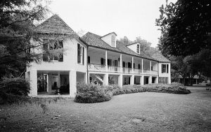
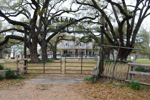
Oakland Plantation
The plantation house of Jean Pierre Emmanuel Prudhomme was most likely constructed by slaves beginning in 1821. Seven generations of the Prud’homme family have occupied it. Many of the original outbuildings for this plantation are intact. Many surviving structures, including the French colonial main house, are examples of bousillage construction. Also important is the landscape, which contains an 1835 bottle garden, a formal entranceway, and intact agricultural fields.
The plantation setting is open and flat, and the only elevation change occurs at the riverbanks, where a few feet drop. The only intrusion in the area is a small metal truss bridge; however, this is not a significant feature in the landscape.
The main house is set at the head of a short alley of live oaks behind a small formal garden. The parterres are outlined in various kinds of bottles – crock bottles from Scotland, square bitters bottles, round-bottom beer bottles from Ireland, torpedo-shaped bottles from England, and wine bottles from France. The main house is a large hip roof, raised cottage, with surrounding galleries and 28 chamfered posts. The three dormers on the front are original. Most rooms have double French doors. The interior walls are paneled with random-width boards. Only one of the original mantels remains – a plain Greek Revival wooden mantel in one of the bedrooms. The finer marble mantels cracked and were replaced with plain wooden mantels in 1915. Most of the transom doors and floorboards are original.
The plantation includes several outbuildings. The old store – a frame, gable-fronted building – dates from the Civil War era. Behind the store is the carriage house, an old but nondescript frame building converted into a machine shop in 1960. Two-frame hip roof pigeoniers are at opposite ends of the access lane, and a small log carpenter’s shop has half dovetail joints at the corners. Behind the carpenter’s shop is an old frame barn that was once a smokehouse; the smoked and charred beams remain. The overseer’s house is a raised cottage that has been re-sided. The largest residence other than the plantation house is the doctor’s house, a five-bay frame cottage with a pitched roof. Though much reworked, it still contributes to the overall appearance of the plantation.
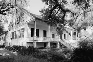
Magnolia Plantation
Slaves most likely constructed the main plantation house of Ambrose LeComte in the 1830s. The large plantation house was burned in 1864 by the army of Union General Banks as they retreated to Alexandria after the battles of Mansfield and Pleasant Hill. Construction of the plantation house was completed in 1899 in an amalgam of Greek Revival and Italianate.
Magnolia Plantation is set along Cane River Lake amid 10 acres of open flat farmland. Several 150-year-old live oaks and magnolia trees surround the big house. The house is approached by a gravel driveway set on the axis with the central front door.
Although the present plantation house dates from 1899, it partially follows the plan of the house that previously occupied the site. The raised plantation house has one principal floor under a large pitched roof garret. The five-bay plan has a central hall and double parlors with chimneys set between them.
There is also a front gallery, a rear gallery encompassing the house, and a rear wing. The house, traditional in form and plan, is large and plain with square post galleries, transom panel doors, and simple Renaissance Revival mantels. The upstairs walls are entirely sheathed in narrow gauge wainscotting with plain mantels. All doors have four panels, and windows are sash-mounted. The 2½-story structure contains 27 rooms and an extensive Southern Empire and Louisiana furniture collection.
The plantation includes several necessary outbuildings and dependencies, such as an overseer’s house, slave quarters cabins, a plantation store, a corn crib, a blacksmith shop, a pigeonnier, and a cotton press-gin building. The cotton press gin building contains a rare cotton press and two types of gins. These remnants of a working plantation are invaluable in understanding Southern antebellum agricultural practices. The unusually large overseer’s house is a hip-roof, raised Acadian cottage, which almost surrounds square post galleries. This structure served as the family residence after the Civil War to reconstruct the large plantation house. Modifications to the overseer’s house include the tin roof and the interior, which is much reworked. The transom, doors, windows, and shutters remain.
Of the original slave dwellings, eight remain in a double row in the southeast portion of the plantation. These are brick, two-room, galleried houses with central chimneys and gable parapets – unusually high-quality construction for slave cabins. Each fireplace has an iron lintel. Some deterioration has occurred, including the loss of several parapets, chimney tops, windows, and doors. In addition, some gallery roofs have collapsed. The cotton press dates back to ca. 1830 and is one of about five or six comparable examples in the South. This building also contains 19th-century ginning equipment. In addition, the landscape of fields and woodlands surrounding the plantation are intact.
Badin-Roque House
The Badin-Roque House is set on flat farmland adjacent to Cane River Lake, approximately 10 miles south-southeast of the city of Natchitoches. It was probably constructed in the early 19th century as a poteaux en terre (posts in the ground) cottage with two front rooms of unequal size and two rear cabins with a small space between. This structure typified bousillage construction techniques. The house had a single central chimney and a dirt floor. In the 1830s, a beaded tongue and groove ceiling were added, as was much of the board and batten fenestration. In about 1850, the present pitched roof and siding were added. In addition, the small rear gallery was enclosed, and a nine-over-six window was installed. In the 20th century, the present tin roof covering was installed. The structure is stable, but some studs have tilted, and the brick fireplaces have partially crumbled.
Cherokee Plantation
The Cherokee Plantation house dates from the 1820s and is named for the Cherokee roses in the front yard. It is typical of early Louisiana plantations and reflects the lifestyles of French planters. South and west of the house are three very old barns, one a “log crib.” Across the road on the riverbank facing the big house is a slave cabin with the original fireplace. This has been restored for caretakers, but the style and flavor have been preserved.
Beau Fort Plantation
Jean Pierre Emmanuel Prudhomme began building this plantation in 1830 for his son, L. Narcisse Prudhomme. It has been modernized with several additions, including a patio, breakfast, kitchen, and storage rooms.
Fort St. Jean Baptiste State Commemorative Area
Louis Juchereau de St. Denis supervised the construction of a small structure in 1713 known as Fort St. Jean Baptiste. This post served as the center for French trading activities, challenged Spanish authority in the area, and stood on a rough boundary between French Louisiana and Spanish Texas. The Spanish responded by establishing a military post and religious mission among the Adaes Indians approximately 15 miles west of the French fort. The fort was moved from an island in the Red River (now Cane River Lake) to the west bank. After 1803, the fort was abandoned and torn down. The Louisiana Office of State Parks in 1971-72 purchased the site of this post. Construction of a replica fort began in 1980 and was completed in 1981.
Compiled and edited by Kathy Alexander/Legends of America, updated March 2024.
Also See:

