
Kansas City Metropolitan Area.
The Kansas City metropolitan area is a bi-state metropolitan area around Kansas City, Missouri. Comprised of 14 counties that straddle the border between Missouri (9 counties) and Kansas (5 counties), it covers 8,472 square miles and has a population of more than 2.2 million people. It is the second-largest metropolitan area in Missouri, with a dominant historical core city in the 1950s (after Greater St. Louis), and the largest metropolitan area in Kansas. However, Wichita is the largest metropolitan area with a 1950s-dominant historical core.
Alongside Kansas City, Missouri, several other suburban cities have populations above 100,000, including Overland Park<, Kansas City, and Olathe in Kansas, and Independence and Lee’s Summit in Missouri.
The Missouri River runs west to east through the area, joined at Kaw Point by the much smaller Kansas River, which approaches from the southwest. Downtown Kansas City, Missouri, is immediately southeast of their confluence, and North Kansas City, Missouri, is to its northeast.

Kansas City Metropolitan Area.
The larger Kansas City metropolitan area can be visualized as a map with roughly four quadrants:
The southeast quadrant includes Kansas City, Missouri, and surrounding areas in Missouri, including the Grandview Triangle.
The southwest quadrant includes all of Johnson County, Kansas, which includes the towns in the area known as Shawnee Mission, Kansas. Interstate 35 runs diagonally through Johnson County, Kansas, from the southwest to Downtown Kansas City, Missouri.
The northwest quadrant contains Wyandotte and Leavenworth Counties in Kansas and parts of Platte County, Missouri. Wyandotte County, Kansas, contains Kansas City, Kansas; Bonner Springs; and Edwardsville, with a single unified government governing it. Another bend in the Missouri River forms the county line between Wyandotte County, Kansas, and Platte County, Missouri, to the north and northeast.
The map’s northeast quadrant is referred to as the Northland. It includes parts of Clay County, Missouri, North Kansas City, Missouri, and Parkville, Missouri. North Kansas City is bounded by a bend in the Missouri River that defines a border between Wyandotte County, Kansas, and Clay County, Missouri, running approximately north-south, and a border between North Kansas City, Missouri, and Kansas City, Missouri, running approximately east-west. The river bend’s sharpest part forms a peninsula containing the Kansas City Downtown Airport.
Neighborhoods of Kansas City, Missouri:
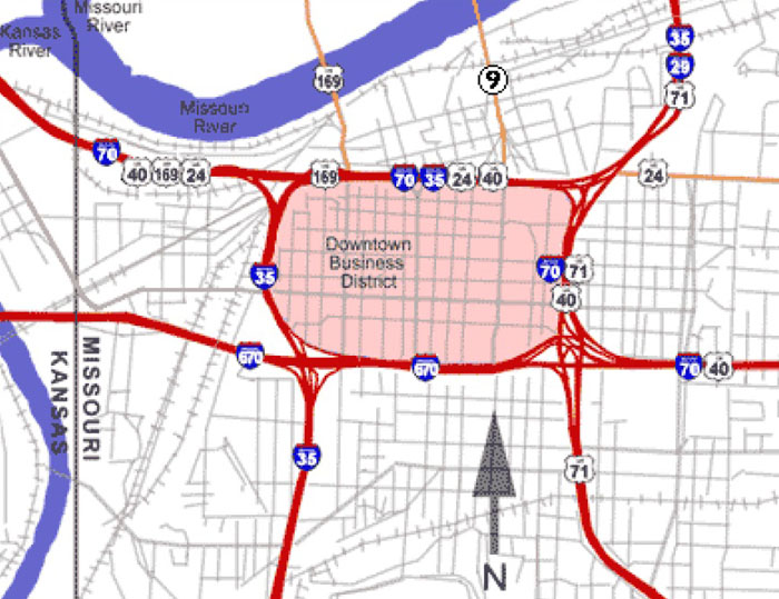
Kansas City Downtown Loop
The center of Kansas City is roughly contained inside the downtown loop.
Downtown Kansas City is a section of western Kansas City, Missouri, where corporate offices and much of the city’s entertainment facilities are located. The area has been undergoing massive revitalization since 2000, and its population increased by over 7,000 people between 2000 and 2005.
With a population of 28,000, Kansas City’s historic center contains the city’s original town site, business districts, and residential neighborhoods. The Missouri River bounds downtown on the north, the Missouri-Kansas state line on the west, 31st Street on the south, and Woodland Avenue on the east. The downtown area includes the Central Business District and its buildings, which form the city’s skyline. The Downtown Loop is formed by Interstates 670, 70, and 35. Many tall buildings and skyscrapers within the downtown loop make up the city’s skyline. The downtown loop also has small, distinct neighborhoods such as Quality Hill, the Garment District, the Financial District, the Convention Center District, and the Power and Light District. The T-Mobile Center and the College Basketball Experience are within the Power & Light District

To-Mobile Center in downtown Kansas City by Kathy Alexander.
The Kansas City Convention Center, Municipal Auditorium, City Hall, Lyric Theater, Midland Theatre, Ilus Davis Park, and Barney Allis Plaza are within the Central Business District inside the downtown loop. The Kauffman Center for the Performing Arts is perched upon a high point immediately south of the downtown loop. The Crossroads District, Union Station, Crown Center, the National World War I Museum, Liberty Memorial, Penn Valley Park, University Health Truman Medical Center, Children’s Mercy Hospital, and the 18th & Vine District are south of the loop. The City Market within the River Market and Richard L. Berkeley Riverfront Park are north of the loop. West of the loop, in the West Bottoms, are Hy-Vee Arena and Hale Arena.
Other nearby neighborhoods are the River Market and Columbus Park, located between the downtown loop and the Missouri River. Between the downtown loop and the state line are the Westside neighborhood and the West Bottoms, located at the bottom of the bluff adjacent to Kaw Point. The 18th & Vine District, the North Bottoms, and Northeast Kansas City (the East Bottoms, Northeast, and Pendleton Heights) are east of the loop. The Crossroads District, Union Hill, Crown Center, Hospital Hill, Longfellow, Wendell Phillips, and Washington Wheatley are south of the loop.
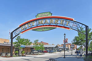
City Market in Kansas City, Missouri, by Kathy Alexander.
The River Market is north of downtown, south of the Missouri River, and west of Highway 9. It is home to a large farmers’ market.
Northland is a section of the metropolitan area north of the Missouri River, comprising Clay and Platte Counties in Missouri. This area includes the northern half of Kansas City, Missouri, referred to as Kansas City, North, to distinguish it from the rest of the Northland and the city of North Kansas City. It also encompasses the cities of Liberty, North Kansas City, and Gladstone. The sharpest part of the river bend forms a peninsula containing the Charles B. Wheeler Kansas City Downtown Airport.
North Kansas City is an enclaved city surrounded by Kansas City, Missouri.
The Waldo Residential District is in Kansas City, Missouri, near 75th Street and Wornall Road.
Country Club Plaza (“the Plaza”) is an upscale shopping district built by the J.C. Nichols Company in 1923. It was the first suburban shopping district in the United States.

Fountain at the Country Club Plaza in Kansas City, Missouri, by Carol Highsmith.
The Country Club District is an associated group of neighborhoods built along Ward Parkway by J.C. Nichols, just south of the Country Club Plaza. It includes Sunset Hill, Brookside, Crestwood, and Mission Hills, Kansas.
39th Street, also called the Volker neighborhood or “Restaurant Row,” is a small section of West 39th Street between State Line Road and the Southwest Trafficway in Kansas City, Missouri. The area has many restaurants, bars, and shops, and is just across the state line from the University of Kansas Medical Center.
The University of Kansas Hospital is the corporate name of the hospital on the KU Medical Center campus.
Benton Curve is a curve at the cross-section of Interstate 70 and Benton Boulevard in Kansas City, Missouri. It has long been prone to traffic accidents.
Pendleton Heights is a neighborhood in the Historic Northeast district of Kansas City, Missouri, where Cliff Drive borders to the north, Chestnut Trafficway to the east, Independence Avenue to the south, and The Paseo to the west. It is Kansas City’s oldest surviving neighborhood and has the city’s largest concentration of Victorian homes.

Kansas City Library District by Carol Highsmith, 2021.
The Library District is a recently defined district around the new Central Library at 14 West 10th Street in Kansas City, Missouri.
Emanuel Cleaver II Boulevard, named for former mayor and Congressman Emanuel Cleaver, comprises portions of 47th Street and Brush Creek Boulevard in Kansas City, Missouri, that were recently renamed.
The 18th and Vine Historic District is a neighborhood on Kansas City, Missouri’s north side that contains the Negro Leagues Baseball Museum and the American Jazz Museum. This area was the heart of Kansas City’s black business district.
Shawnee Mission is a United States Postal Service district encompassing 16 cities and towns in northeast Johnson County, Kansas, most of which also lie within the school district of the same name.
135th Street is a shopping area in Overland Park, Kansas, featuring several indoor and outlet malls, restaurants, and two movie theaters.

The colorful walls of the Museum at Prairiefire in Overland, Kansas, a Kansas City suburb. Photo by Carol Highsmith.
Prariefire, also in Overland Park, Kansas, is a modern shopping and leisure area featuring fine restaurants and a high-end bowling venue. The Museum of Prariefire is its main attraction.
Strawberry Hill is a historical area in Kansas City, Kansas, home to many Eastern European immigrants. Later, the neighborhood became home to many Latino families.
Hospital Hill is an area near 23rd Street and Holmes Avenue in Kansas City, Missouri. It consists of two major hospitals: University Health and the Children’s Mercy Hospital. The University of Missouri’s Kansas City School of Medicine, Dentistry, Pharmacy, and Nursing are also located here.
Argentine is a neighborhood in Kansas City, Kansas, centered along Metropolitan and Strong avenues from 27th to 30th streets. It is one of the oldest Mexican/Latino neighborhoods in Kansas City, with Mexican immigration to that area starting in the 1800s.
The Crossroads Arts District is a neighborhood in downtown Kansas City, Missouri, between the Central Business District and Union Station, centered around the intersection of 19th Street and Baltimore Avenue. It contains dozens of art galleries and is considered the center of the metropolitan area’s art culture. Local artists sponsor exhibits in the district on the first Friday of each month.

Historic buildings in Westport, Kansas, by Kathy Alexander.
Westport is a historic district with the city’s oldest building still standing. It is home to much of the metropolitan area’s entertainment and nightlife.
Quality Hill is a residential and commercial neighborhood atop the bluff on the west side of the Central Business District of Downtown Kansas City, across the river from the Charles B. Wheeler Airport.
Washington-Wheatley is a historically Black neighborhood southeast of the 18th and Vine Historical District.
The Westside is a historically African American and Chicano/Latino neighborhood near Southwest Boulevard and Interstate 35.
Valentine is a neighborhood north of Westport, home to the historic Uptown Theater.
Rosedale is the southernmost district of Kansas City, Kansas, and the only part of that city whose streets are on the metropolitan grid. Home to the main hospital of the University of Kansas Health System, it was the last municipality absorbed by Kansas City, Kansas, before the creation of the Unified Government of Kansas City and Wyandotte County.

West Bottoms Buildings in Kansas City, Missouri, by Kathy Alexander.
The West Bottoms has many of the city’s oldest buildings and was once the site of the city’s stockyards. It is now known for its arts community, the American Royal, Hy-Vee Arena, antique stores, and First Fridays events.
Union Hill is a historic neighborhood in Kansas City, Missouri. The mixed-use, 16-block luxury urban development is between 27th Street and 31st Street, and between Main Street and Gillham Road. It is home to many dining, shopping, and nightlife destinations.
Armourdale is a residential and commercial neighborhood in Kansas City, Kansas, and is one of the historically Chicano neighborhoods of the Kansas City metropolitan area.
Sheffield is an industrial district in the Blue River Valley on the city’s far northeast side.
The East Bottoms, also known as the Industrial District, is primarily known for its industrial businesses and railroad activity.
Hanover Heights is a small neighborhood in the Rosedale section of Kansas City, Kansas, once known primarily for the antique shops along 45th Avenue. The neighborhood’s boundaries run mainly between Rainbow Boulevard and State Line Road, south of the KU Medical Center to the Johnson County border.

Brookside Street, by Kathy Alexander.
Brookside is a pedestrian-friendly district built in the 1920s, centered on the Brookside Shopping District at 63rd Street and Brookside Boulevard.
The Historic Northeast District is a collection of working-class immigrant neighborhoods between downtown Kansas City and the suburb of Independence.
The Grandview Triangle is the intersection of four major highways: Interstate 435, Interstate 470, Interstate 49, and U.S. Route 71 (Bruce R. Watkins Drive). Notorious for fatal accidents, the Triangle has undergone improvements and upgrades in recent years.
The Midtown/Plaza neighborhood is entirely within Kansas City, Missouri, with a population of 40,463. It is south of downtown and bounded by 31st Street on the north, the state line on the west, West Gregory Boulevard (71st Street) on the south, and Troost Avenue on the east. It is broken up into the historical neighborhoods of Westport, the Country Club Plaza, Hyde Park, Ward Parkway, Brookside, West Plaza, Southmoreland, Valentine, Coleman Highlands, and Rockhill.
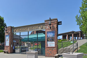
Starlight Theatre at Swope Park, in Kansas City, Missouri, by Kathy Alexander.
Midtown/Plaza, the metropolitan area’s core, is home to many cultural attractions, shopping and entertainment areas, large hospitals, universities, and the metro area’s most densely populated neighborhoods. The Country Club Plaza shopping centers have luxury retailers, hotels, and restaurants. Brookside and Westport also contain smaller-scale, neighborhood-oriented, and niche-market retailers. Midtown is home to Saint Luke’s Hospital of Kansas City and Research Medical Center. Cultural attractions include the Nelson-Atkins Museum of Art, the Kemper Museum of Contemporary Art, the Uptown Theater, the Starlight Theater, the Kansas City Zoo, Loose Park, and Swope Park. The last of these has a soccer complex home to the Swope Park Rangers, a USL Championship team that is the official reserve side for the area’s Major League Soccer club, Sporting Kansas City. Prominent educational institutions include the University of Missouri–Kansas City, Rockhurst University, the Kansas City Art Institute, the Stowers Institute for Medical Research, the Midwest Research Institute, and Penn Valley Community College.
The East Side of the Metro is primarily eastern Jackson County, an area of the Kansas City Metro that includes the far eastern urban side of Kansas City, Missouri, and the following large suburbs: Blue Springs, Independence, and Lee’s Summit. The area includes western Lafayette County, Missouri, and the far northeast portion of Cass County, Missouri. The East Side of Metro includes the Missouri suburbs of Independence, Grandview, Blue Springs, Raytown, Lees Summit, Grain Valley, Oak Grove, Sugar Creek, River Bend, Lake Lotawana, Lone Jack, Greenwood, Unity Village, Buckner, Pleasant Hill, Bates City, Odessa, and Lake Tapawingo. Arrowhead Stadium, home of the NFL’s Kansas City Chiefs, and Kauffman Stadium, home of the MLB’s Kansas City Royals, are on the eastern edge of Kansas City. The Cable Dahmer Arena, home of the ECHL’s Kansas City Mavericks and the MASL’s Kansas City Comets, is in Independence.
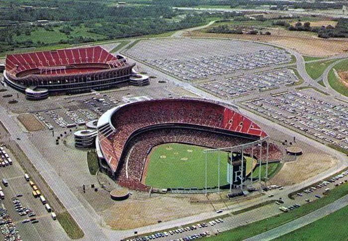
Truman Sports Complex in Kansas City, Missouri.
The Truman Sports Complex, at the junction of I-70 and I-435, east of downtown Kansas City, Missouri, is home to several professional sports attractions. It is anchored by Arrowhead Stadium, home of the Kansas City Chiefs NFL franchise, and Kauffman Stadium, home of Major League Baseball’s Kansas City Royals.
The Northland is north of the Missouri River, bordered by the Kansas state line on the west. The area comprises the southern half of Platte County and much of Clay County. The Northland is a fast-growing, primarily suburban region of the metropolitan area, although much of it is within the city limits of Kansas City, Missouri. The economy of the Northland is dominated by Cerner, Kansas City International Airport, Ford Kansas City Assembly Plant, the Zona Rosa shopping community, and three riverboat casinos. The metro area’s largest amusement park, Worlds of Fun and Oceans of Fun, is in the Northland. Prominent educational institutions in the Northland include Park University, William Jewell College, and the Maple Woods campus of Metropolitan Community College. The Northland is also home to the popular recreational reservoir, Smithville Lake. Communities of the Northland outside the city limits include Parkville, Kearney, Liberty, Platte City, Gladstone, Riverside, Smithville, North Kansas City, and Weatherby Lake.
Overland Park, Kansas Buildings by Kathy Alexander.
Johnson County, Kansas, contains many municipalities with a population of 609,863. It has the largest economy in the metropolitan area and is the fastest-growing county by total population. Municipalities include Overland Park, Olathe, Shawnee, Leawood, Lenexa, Prairie Village, Gardner, Merriam, Mission, Roeland Park, Fairway, Lake Quivira, Mission Hills, Mission Woods, Westwood, and Westwood Hills. Corporate headquarters include Garmin, Black & Veatch, AMC Theatres, and T-Mobile’s secondary headquarters. Many local attractions and shopping districts are in Johnson County, including Oak Park Mall, Town Center Plaza, and Prairie Fire.
Wyandotte County, Kansas, has a population of 169,245 and contains Kansas City, Kansas, Bonner Springs, Kansas, and Edwardsville, Kansas. Kansas City, Kansas, is locally called “KCK” to distinguish it from the larger Kansas City, Missouri. It contains many residential neighborhoods, the Fairfax Industrial District, and the Village West entertainment district. The General Motors Fairfax Assembly Plant is in the Fairfax Industrial District. Village West contains many area attractions, including many sporting venues such as Children’s Mercy Park, home of the area MLS soccer team Sporting Kansas City; the Kansas Speedway, which hosts many NASCAR races; and Field of Legends, home of the independent baseball team, the Kansas City Monarchs, and the Legends shopping district. Bonner Springs is home to the Azura Amphitheater, the National Agricultural Center and Hall of Fame, the Wyandotte County Historical Museum, and the annual Kansas City Renaissance Festival.
Cass County, Missouri, has a population of 107,824 and contains parts of “South Kansas City.” This area consists of the southern part of Kansas City, Missouri, and the suburbs of Harrisonville, Belton, Loch Lloyd, Peculiar, and Raymore.
Leavenworth County, Kansas, has a population of 81,881 and includes the cities of Leavenworth and Lansing, as well as the Leavenworth Federal Penitentiary.
The population of the Kansas City Metro Area in 2020 was 2,192,035.
By population, the cities rank from highest to lowest in 2020:
| Kansas City, Missouri – Population of 508,090 | Oak Grove, Missouri – Population of 7,937 | Wellsville, Kansas – Population of 1,818 |
| Overland Park, Kansas – Population of 197,238 | Bonner Springs, Kansas – Population of 7,606 | Edgerton, Kansas – Population of 1,736 |
| Kansas City, Kansas – Population of 156,607 | Roeland Park, Kansas – Population of 6,827 | Westwood, Kansas – Population of 1,719 |
| Olathe, Kansas – Population of 141,290 | Parkville, Missouri – Population of 6,296 | Hamilton, Missouri – Population of 1,690 |
| Independence, Missouri – Population of 123,011 | De Soto, Kansas – Population of 6,074 | Garden City, Missouri – Population of 1,625 |
| Lee’s Summit, Missouri – Population of 101,108 | Richmond, Missouri – Population of 6,013 | Gower, Missouri (partial) – Population of 1,526 |
| Shawnee, Kansas – Population of 67,311 | Spring Hill, Kansas – Population of 5,981 | Claycomo, Missouri – Population of 1,468 |
| Blue Springs, Missouri – Population of 58,063 | Greenwood, Missouri – Population of 5,569 | Lone Jack, Missouri – Population of 1,124 |
| Lenexa, Kansas – Population of 57,434 | Paola, Kansas – Population of 5,527 | Drexel, Missouri – Population of 999 |
| Leavenworth, Kansas – Population of 37,351 | Basehor, Kansas – Population of 5,403 | Orrick, Missouri – Population of 753 |
| Leawood, Kansas – Population of 33,902 | Tonganoxie, Kansas – Population of 5,248 | Braymer, Missouri – Population of 737 |
| Liberty, Missouri – Population of 30,167 | Odessa, Missouri – Population of 5,178 | Lake Tapawingo, Missouri – Population of 723 |
| Raytown, Missouri – Population of 30,012 | Peculiar, Missouri – Population of 4,885 | Glenaire, Missouri – Population of 578 |
| Gladstone, Missouri – Population of 27,063 | Platte City, Missouri – Population of 4,833 | Hardin, Missouri – Population of 571 |
| Grandview, Missouri – Population of 26,209 | Higginsville, Missouri – Population of 4,662 | Polo, Missouri – Population of 509 |
| Belton, Missouri – Population of 23,953 | Lexington, Missouri – Population of 4,598 | Dearborn, Missouri (partial) – Population of 496 |
| Gardner, Kansas – Population of 23,287 | Edwardsville, Kansas – Population of 4,390 | Avondale, Missouri – Population of 440 |
| Prairie Village, Kansas – Population of 22,957 | North Kansas City, Missouri – Population of 4,354 | Osborn, Missouri (partial) – Population of 423 |
| Raymore, Missouri – Population of 22,941 | Osawatomie, Kansas – Population of 4,297 | Sibley, Missouri – Population of 356 |
| Grain Valley, Missouri – Population of 15,627 | Louisburg, Kansas – Population of 4,276 | Kingston, Missouri – Population of 290 |
| Ottawa, Kansas – Population of 12,387 | Fairway, Kansas – Population of 3,970 | Henrietta, Missouri – Population of 278 |
| Lansing, Kansas – Population of 11,767 | Mission Hills, Kansas – Population of 3,601 | Breckenridge, Missouri – Population of 258 |
| Excelsior Springs, Missouri – Population of 11,486 | Sugar Creek, Missouri – Population of 3,320 | Camden, Missouri – Population of 175 |
| Merriam, Kansas – Population of 11,288 | Riverside, Missouri – Population of 3,150 | Cowgill, Missouri – Population of 168 |
| Smithville, Missouri – Population of 10,406 | Buckner, Missouri – Population of 3,067 | Oaks, Missouri – Population of 129 |
| Harrisonville, Missouri – Population of 9,986 | Pleasant Valley, Missouri – Population of 3,056 | Fleming, Missouri – Population of 114 |
| Cameron, Missouri (partial) – Population of 9,933 | Lawson, Missouri – Population of 2,409 | Unity Village, Missouri – Population of 84 |
| Mission, Kansas – Population of 9,491 | Plattsburg, Missouri – Population of 2,291 | Levasy, Missouri – Population of 83 |
| Kearney, Missouri – Population of 9,423 | Lake Lotawana, Missouri – Population of 2,018 | Randolph, Missouri – Population of 54 |
| Pleasant Hill, Missouri – Population of 8,289 | Weatherby Lake, Missouri – Population of 1,848 | River Bend, Missouri – Population of 10 |
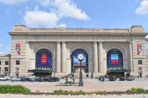
Union Station in Kansas City, Missouri, by Kathy Alexander.
Within the Kansas City Metropolitan area, cultural attractions include the American Jazz Museum, the Kansas City Symphony, Kansas City Union Station, the National World War I Museum, the Nelson-Atkins Museum of Art, the Kemper Museum of Contemporary Art, Kauffman Center for the Performing Arts, the National Agricultural Center and Hall of Fame, Negro Leagues Baseball Museum, Arabia Steamboat Museum, Uptown Theater, Midland Theatre, the Kansas City Zoo, Swope Park (featuring Starlight Theater), Azura Amphitheater, the Kansas City Renaissance Festival, Worlds of Fun, Oceans of Fun, and several casinos. Major league sports franchises include the NFL’s Kansas City Chiefs, the MLB’s Kansas City Royals, and the MLS’s Sporting Kansas City. NASCAR owns the Kansas Speedway.
Historic features include the confluence of the eastern endpoints of the California, Santa Fe, and Oregon Trails in Independence, the Harry S. Truman Historic District, and the neighborhoods of Westport, 18th and Vine, and Pendleton Heights. Historic cultural origins include Kansas City jazz, vaudeville, barbecue, and steak.
The Kansas City metropolitan area’s largest private employer is Cerner Corporation. Cerner, a global healthcare IT company headquartered in North Kansas City, employs nearly 10,000 people in the area and has a total workforce of nearly 20,000, including global employees. In August 2014, the company announced its acquisition of competitor Siemens Healthcare. Cerner has several campuses across the area, including its World Headquarters in North Kansas City, the Innovations Campus in South Kansas City, and the Continuous Campus in Kansas City, Kansas.
Other major employers and business enterprises are AT&T, BNSF Railway, GEICO, Asurion, T-Mobile (formerly Sprint), Citigroup, EMBARQ, Farmers Insurance Group, Garmin, Hallmark Cards, Husqvarna, H&R Block, General Motors, Honeywell, Ford Kansas City Assembly Plant, MillerCoors, State Street Corporation, The Kansas City Star, Waddell & Reed, Black & Veatch, AMC Theatres, Bayer, Children’s Mercy Hospital, Truman Medical Center-Hospital Hill, and Andrews McMeel Universal (representing Garfield, Calvin and Hobbes, and Doonesbury.) Some of these companies are headquartered in the metropolitan area.
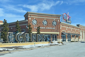
Legends Outlets in Kansas City, Kansas, by Kathy Alexander.
Shopping centers include City Market, Crown Center, Country Club Plaza, Independence Center, Legends Outlets Kansas City, Oak Park Mall, Ward Parkway Center, and Zona Rosa.
The fundamental conclusion is that Kansas City ranks better than most major metropolitan areas in the United States on housing affordability, traffic congestion, and productivity.
Kansas City is the 29th-largest metropolitan area in the United States, with over 2.2 million residents. Approximately 23% of the population is in the historical core municipality of Kansas City, Missouri, while 42% percent live in the Kansas suburbs and 36% live in the Missouri suburbs. The Kansas City metropolitan area is overwhelmingly suburban, typical of U.S. metropolitan areas. Only 11% of the area’s population lives in parts of the metropolitan area, reflecting pre–World War II population densities and travel patterns. In Kansas City, as has been typical in high-income countries, nearly all population growth since World War II has been suburban.
The Kansas City metropolitan area has grown by more than 100% since 1950, though only 1% of that growth occurred within the city limits of Kansas City, Missouri. All growth in Kansas City, Missouri, has been in functionally suburban areas, which is unlikely to change. Population projections indicate that suburban areas will likely attract the overwhelming majority of future population growth. Likewise, most employment growth has been outside the city, and projections indicate that this trend will continue.
Competitive Analysis: Kansas City has considerable advantages. The cost of living in the Kansas City metropolitan area is lower than average, attributed to Kansas City’s superior housing affordability. Cost-of-living differences between U.S. metropolitan areas primarily reflect differences in housing affordability.
Kansas City Freeways, courtesy Missouri Department of Transportation.
Housing affordability tends to be better in metropolitan areas with less restrictive land-use regulations than in those with strong land-use regulations, such as urban containment policies. With its liberal land-use regulations, Kansas City has retained its housing affordability, even as similarly sized metropolitan areas, such as Portland, Oregon, and Denver, Colorado, have experienced significant declines in housing affordability. Better travel times in metropolitan areas have been associated with higher economic growth. Kansas City has a superior urban transportation system. It is also ranked as the second-least-congested metropolitan area in the U.S. with a population over 800,000, and its average work-trip travel times are among the shortest in the United States. Kansas City’s success in transportation results from an effective freeway system, a high-quality arterial street system, low population density, and employment dispersion. Kansas City is also one of the most essential freight transport and logistics centers in the United States. Interstate highways serve Kansas City from six directions and by all four of the nation’s largest railroads. It is home to two large truck–rail logistics centers and an air freight logistics center.
Kansas City’s most significant advantages are its low cost of living, superior mobility, and a wide range of lifestyle options. Kansas City’s lower cost of living makes a high standard of living possible and reduces poverty. Kansas City’s greater mobility is expected to lead to stronger economic growth and more leisure time for residents. For middle-income households, Kansas City is genuinely world-class. The key challenge for Kansas City will be retaining its most significant advantages as it seeks economic and population growth. Kansas City has a unique opportunity to set itself apart from competitors in metropolitan areas by implementing policies that make housing less affordable for middle-income households and more challenging to get around. It will be necessary for the Kansas City metropolitan area to continue policies that permit environmentally sensitive, affordable housing development and to make sufficient improvements to the roadway system to preserve or improve mobility.
According to the Kansas City Area Development Council, the Kansas City Metropolitan Area ranks very well on the cost-of-living index compared to other cities.
The 2023 Annual Averages for several cities were:
| City | Cost of Living | Median Sales Price, Existing Single-Family Homes |
| Austin, TX | 98.9 | $485,700 |
| Boston, MA | 146.5 | $745,100 |
| Dallas, TX | 102.1 | $385,700 |
| Denver, CO | 110.3 | $673,000 |
| Kansas City, MO-KS | 93.7 | $328,800 |
| Los Angeles-Long Beach, CA | 148.9 | $897,600 |
| Minneapolis, MN | 93.3 | $387,900 |
| Phoenix, AZ | 101.9 | $467,200 |
| United States | 100.0 | $406,900 |
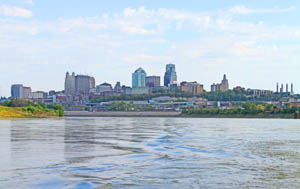
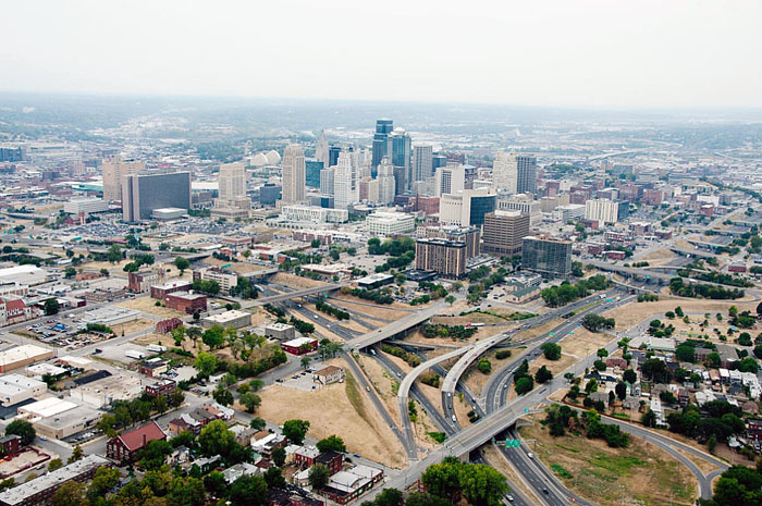
Kansas City Skyline from the Missouri River by the Corps of Engineers.
According to the Census Reporter and the World Population Review, demographics for 2022 indicated the following for the Kansas City Metropolitan Area:
![]() The median age is 38.2 years.
The median age is 38.2 years.
The population comprises 50% females and 50% males.
![]() The per capita income was $42,257, which is about the same as the amount in the United States: $41,804
The per capita income was $42,257, which is about the same as the amount in the United States: $41,804
The median household income was $75,280, about the same as the amount in the United States: $74,755
10.7% of the population lives below the poverty line, compared to the rest of the United States, which is 12.6%
![]() The average commute time to work was 22.9 minutes, compared with 26.4 minutes nationwide.
The average commute time to work was 22.9 minutes, compared with 26.4 minutes nationwide.
The number of households in the metropolitan area was 897,185, compared to an average of 129,870,930 across other metropolitan areas. There were 2.4 people per household, slightly less than the figure in the United States: 2.5. Married couples were the most significant household type, at 60%.
![]() The median value of owner-occupied housing units was $274,500, about 90% percent of the amount in the United States: $320,900
The median value of owner-occupied housing units was $274,500, about 90% percent of the amount in the United States: $320,900
The rate of home ownership was 54.0%. The ownership rate for married couples is 77.7%. Males outrank females in home ownership.
50% of the population was married.
![]() The average family size was 3.11.
The average family size was 3.11.
93.4% of the population were high school graduates or higher. This rate is slightly higher than the United States’ rate of 89.6%. The unemployment rate for those with less than a high school education was 10.2%.
![]() 39.7% of the population had obtained a bachelor’s degree or higher. This is about 10% higher than the United States rate of 35.7%. The unemployment rate for those having a bachelor’s degree or greater was 1.8%.
39.7% of the population had obtained a bachelor’s degree or higher. This is about 10% higher than the United States rate of 35.7%. The unemployment rate for those having a bachelor’s degree or greater was 1.8%.
Females outrank males in educational attainment in all areas, from high school to graduate degrees.
The metro area is the second-largest in Missouri after Greater St. Louis.
The most densely populated area is within the Historic Kansas City boundary, covering about 58 square miles and with a density of about 5,000 people per square mile. The city’s urban core has lost population for the past 13 years, while only a few areas—especially the Greater Downtown in the city center—have gained population. The most significant growth has been in the Northland area.
The Kansas City metropolitan area covers 7,952 square miles, with a population density of 260 people per square mile.

Kansas City, Missouri, Skyline, courtesy Wikimedia.
©Kathy Alexander/Legends of America, updated January 2026.
Chapel Christian Church at Longview Farm, Lee’s Summit, Missouri, by Dave Alexander.
Also See:
Sources: