“Maps are not the whole of geography, but there can be no geography without them.”
— Sarah Witham Bednarz, Gillian Acheson, and Robert S. Bednarz
While recognized as “the most important tool in geography,” maps are also a popular and practical resource for teaching history. They can be a great asset to any classroom or home school environment, as they can tell stories and are not just representations of spatial regions. In addition to social studies and history, their uses can be extended into science and literature.
“Maps record past … situations, past relationships… [there is] no area of American history where maps don’t [add to] our understanding.”
— Susan Schulten, author of A History of America in 100 Maps
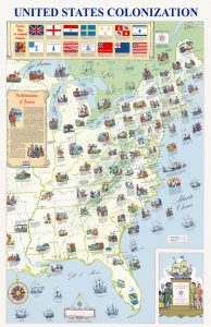
Colonial America by the Exxon Corporation, 1972. Click for 8.5 x 11 printing. Click HERE for a mini-poster print.
Historical maps often display information not retained by other written sources. These can include boundaries, place names, and physical features that no longer exist today. Historical maps can also capture the attitudes of those who made them and represent views of their time.
One of the most apparent reasons educators use maps is to teach students how to read and interpret maps. In this case, students learn about latitude and longitude, direction, legend, and scale. More information may also be provided about the maps used, such as physical, topographic, and locating places.
Simply put, maps can show how a state or county is set up, where places are, and where you live in your country and the world. Further instruction will help students to calculate distances and travel time, providing more information about scale.
Through viewing maps, students can not only understand the distance between things and how to use maps. Still, they can also explore settlement and migration patterns, the importance of physical boundaries and features, the importance of waterway access, and the reasons wars have been fought over these things.
Regarding history, maps can be powerful visual tools that provoke us to think about the how and why of history. When teaching English, Language Arts, or Science. In any teaching situation, maps can bring stories to life when students are shown where a story takes place.
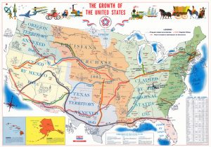
Growth of the United States by the Exxon Corporation, 1976. Click for 8.5 x 11 printing. Click HERE for a mini-poster print.
Ask Students to Determine:
What is the theme and time period of the map?
How does the map deal with the events of the time period? Does it reflect the migrations of people, the reasons for wars and revolutions, commerce and economy, or other purposes?
Can the map chart a journey of a particular person or expedition?
Ask Students to Identify and Describe What They See:
What do you notice first?
What on the map looks strange or unfamiliar?
Describe anything that looks like it does not belong on the map.
Why do you think this map was made?
How does this map compare to current maps of this place?
If this map was made today, what would be different?
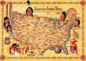
American Indian Tribes Poster. Click for 8.5 x 11 printing. Click HERE for a mini-poster print.
More Educational Opportunities:
Ask students to role-play, participate in games, solve problems, and make their own maps.
Hopefully, this will arouse their natural curiosity to explore the journey of cartographers, explorers, and ordinary people and inspire them to talk about and share their thoughts.
Utilize a Timeline:
Using maps against a timeline helps to put events in order, helping students to understand the development of a particular event or historical era.
It also helps students remember the chronological sequence of different events and how historic events, eras, and topics overlap.
Today, maps are a fundamental teaching tool that aids lessons in various subjects and can help contextualize the lesson.
Legends of America makes numerous maps available in 11×17 mini-posters and 8×11 free printable downloads.
With great teaching utilizing maps, we hope to see students become armchair explorers and allow them to travel back in time.
© Kathy Alexander/Legends of America, updated April 2023.
Also See:
State Capitols in the United States
Sources:
Authentic Ireland
David Rumsey Maps
Open Educational Resources
Palace of the Governors
Social Studies.org
Teaching History
World History Connected
Your Child Learns


