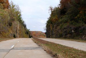
Hooker Cut, Route 66, Missouri.
As you continue your journey on Route 66 from Jerome, you’ll soon enter Pulaski County, the self-proclaimed Heart of the Ozarks. The Pulaski County Tourism Bureau offers a free brochure with turn-by-turn directions and historic details along Pulaski’s original 33 miles of the Mother Road to enhance your travels. You may order it online from their website or download the brochure. You will also find a complimentary audio tour.
Through this area, the Mother Road cuts through large rock bluffs, over streams, and through lush valleys, offering numerous glimpses of vintage restaurants, auto courts, and service stations. One of the most scenic drives on Route 66, you’ll soon pass over a pristine four-lane section of the Mother Road built to carry traffic to and from Fort Leonard Wood during World War II. The first twisting, narrow stretch of Route 66 through Devil’s Elbow was inadequate for the many moving men and equipment, and the new four-lane stretch was completed in 1943. Today, most of this old four-lane highway is still original and is in very good condition considering its age. Passing through the steep bluffs of the Big Piney River, the Hooker Cut was one of the deepest road cuts in the nation at the time of its construction.
Interestingly, the curbs along this stretch are inclined towards the roadway. This was a common building practice at the time, as it was believed that such a design would keep cars from going off the road. However, they soon discovered that the curb design caused cars to overturn, and it was discontinued.
Devil’s Elbow – A Sharp Bend in the River
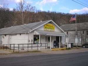
Sheldon’s Market, Devil’s Elbow, Missouri
Turn left before crossing the Big Piney River to take the older alignment through Devil’s Elbow. This community began around 1870 as a lumberjack town when logs were floated down the river. During those old timber days, a large boulder where the river bends was constantly causing log jams, hence the name Devil’s Elbow. Later, when Route 66 was built through the area, the settlement became a resort community with cabins, inns, service stops, and canoe rentals.
In this small community, you feel like you have stepped back in time as you drive this endearing piece of the old Mother Road. Sheldon’s Market, which also houses the post office, began as Miller’s Market in 1954 and later became Allman’s Market. The Elbow Inn Bar and Barbeque Pit was established in 1929 and is one of the oldest original buildings on Route 66 that still operates as the same type of business. The Elbow Inn was the former home of the Munger Moss Sandwich Shop, which moved to Lebanon in 1946 after the highway was realigned through the Hooker Cut.
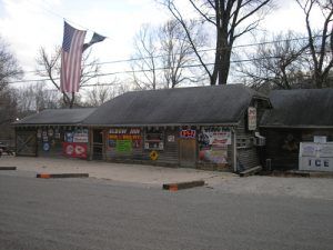
Devil’s Elbow Inn
An old, still truss bridge, dating back to 1926, crosses the Big Piney River in Devil’s Elbow, and a McCoy’s Store and Camp, built in 1941, still stands. Though no longer open, it once had a busy store on the lower level and rented rooms to Route 66 travelers during its heyday.
In late April 2017, a record flood struck Devil’s Elbow. According to the Waynesville Daily Guide, water from the overflowing Gasconade River rose over the historic Route 66 Bridge and hit the roof of the Elbow Inn. Homes were also reported to be swept off their foundations during the unusually heavy rains. Portions of Route 66 were washed away. In addition to flooding at Devil’s Elbow, some residents in Waynesville were also forced to evacuate due to flooding from the Roubidoux River.
Waynesville Epitomizes Main Street USA

Historic Waynesville, Missouri
After leaving Devil’s Elbow, you will enter Saint Robert, which features George M. Reed Park, one of the last remaining roadside parks along the route in Missouri. Then you’ll enter Waynesville with its quaint downtown district that epitomizes Main Street USA. Waynesville started in 1831 when a man named G.W. Gibson “squatted” on the land where the town sits today. One year later, Pulaski County was formed, and Waynesville was soon designated as the county seat. In 1835, James A. Bates opened one of the first stores in the settlement, which also served as a temporary courthouse. In 1839, the town was platted, and a post office opened, named after the famous General “Mad Anthony” Wayne, the daring Revolutionary War hero and Indian fighter.
Like much of Missouri, Waynesville declared itself “Confederate” during the Civil War, flying the rebel flag over its courthouse. However, this was short-lived due to its strategic location on the Wire Road. On June 7, 1862, Federal troops marched in, took over the town, and built a fort to protect the Wire Road.
The town existed due to lumber and agricultural interests until Route 66 came through, and it developed into the tourist community it is today.
At the junction of Route 66 and Highway 17, you officially enter Waynesville. On the historic square are several historic buildings, including the Old Stagecoach Stop Museum, which first served as a stagecoach way station and post office when it was built in 1850. During the Civil War, it was commandeered by the Federal Army and used as a hospital as the Union forces built the fort on the south side of the square. Later, it would serve as a hotel, a boarding house, and a private residence. It had fallen into severe disrepair more than a century later and was condemned by the city in 1982. However, Waynesville citizens rallied and saved the building. Today, it is listed on the National Register of Historic Places. Also on the square is the Old Route 66 Courthouse Museum, built in 1903 and serving Pulaski County until 1989.
Witmore Farms, Waynesville, Missouri.
At Route 66 and Benton Street, you can see a building that was initially the Rigsby Standard Oil station, serving Route 66 travelers in its heyday. You may want to download the Waynesville Downtown Walking Tour or pick up a copy at one of the many shops around the square.
According to Beth Wiles, Executive Director of the Pulaski County Tourism Bureau, downtown Waynesville has undergone a significant renovation. There is now a tourist district a few doors down from the Rigsby Station, which offers a Route 66 Candy Shop, gift shops that carry Route 66 memorabilia, and wine and moonshine tastings. Hoppers across the street from the Route 66 Courthouse Museums offer up 66 beers on tap. It is named in honor of Frog Rock, the huge frog that overlooks Route 66 as you enter town. Waynesville also partnered with the National Park Service on the Trail of Tears Memorial and Interpretive Trail. This is located just before the Roubidoux Bridge, on the left, in Laughlin Park. The storyboards take visitors along concrete pathways that follow the river and along the pathway and boardwalk to the Roubidoux Spring and underwater cave.
As you head out of town, you enter the area known as Buckhorn and cross the Interstate 44 overpass, where you will see the small Pleasant Grove Church, which has been serving its congregation since 1926. A bit further down the road sits the building that once housed Hillcrest Grocers & Station, which pumped KanOTex gas in 1932.
Route 66 takes a right turn on County Road P, where you will drive through the old town of Laquey (pronounced “Lakeway.) Continuing to follow the old route, you’ll soon see signs of the area once called Gascozark and the small town of Hazelgreen before reaching Lebanon. Along this stretch, keep an eye out for several historic buildings that once catered to travelers along the old highway.
©Kathy Alexander/Legends of America, updated November 2025.
Also See:
About Route 66 Through Missouri
Route 66 in Missouri Photo Gallery
See Sources.


