
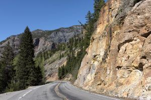
Million Dollar Highway between Silverton and Ouray by Carol Highsmith.
In southwest Colorado, US Highway 550 between Durango and Ouray, high in the San Juan Mountains, is more often called the “Million Dollar Highway.”
Million Dollar Highway by Carol Highsmith.
Consistently voted as one of the top ten scenic highways in the United States, the 70-mile Million Dollar Highway twists and turns through the mountains, providing visitors with breathtaking views of the San Juan Mountain Range and the Uncompahgre Gorge, as well as numerous opportunities to stop or turn off to visit places such as the Victorian-age mining towns of Durango, Silverton, and Ouray; the Red Mountain Mining District ghost towns of Red Mountain City and Ironton, ride a narrow-gauge railroad, hike miles of trails, and ride a jeep over America’s highest backroads.
The twisting two-lane highway is also filled with hairpin turns and exposed sections without guardrails, so drivers must watch the road while passengers enjoy the views.
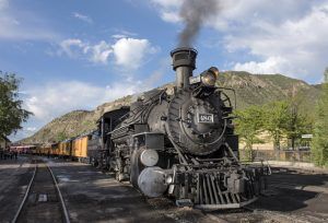
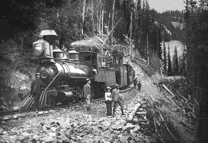
The Durango & Silverton Narrow Gauge Railroad by Carol Highsmith.
This road section is part of the 235-mile-long San Juan Skyway that extends west from Durango to Mancos and Cortez before it turns northeast to Delores and Telluride, continuing to Ridgeway and looping back to Ouray, where it joins the Million Dollar Highway.
From Durango, US 550 makes its way to Silverton for 48 miles, loosely parallelling the Durango & Silverton Narrow Gauge Railroad. The road travels by Trimble Springs, hot springs open for visitors since the late 19th century. It then runs north along the Animas River through the Hermosa Valley and the San Juan National Forest, where it goes past Haviland Lake and Electra Lake.
Drivers pass by Engineer Mountain and Twilight Peak before climbing over Coal Bank Pass, which has a summit of 10,660 feet. It then makes its way to Molas Pass at an elevation of 10,899 feet, which offers a panoramic view of Molas Lake, the Animas River Gorge, and Snowdon Peak.
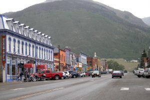
Greene Street in Silverton, Colorado, by Kathy Alexander.
The road then descends into Silverton, where numerous historic buildings and mine tours at the Old Hundred Gold Mine and the Mayflower Mill can be seen.
The highway continues from Silverton for 23 miles to Ouray. It proceeds up Mineral Creek Valley before ascending to Red Mountain Pass at 11,075 feet. The ruins of the Longfellow Mine are visible along the way. At the top of the pass are several pull-outs, where the mining ruins of the rich Red Mountain District can be seen. The road then begins to gradually decline about 2,000 feet as it makes its way along the stunning, steep canyon walls of Uncompahgre Gorge. Along the way, numerous mining sites can be viewed from the highway in what was once the booming Red Mountain Mining District. Before reaching Ouray, Lookout Point offers a grand view of the town of Ouray. Along this trek, the road has steep grades, hairpin curves, and no guard rails. Ouray, a picturesque town known as “Little Switzerland of America,” provides one main street, no traffic lights, three waterfalls, four hot springs, and the famous Ouray Ice Park.

Main Street in Ouray, Colorado by Carol Highsmith.
The entire highway takes its nickname from its most storied 12 miles of tight, winding road from the summit of Red Mountain Pass through the Uncompahgre Gorge south of Ouray.
There are several stories about how the road became the “Million Dollar Highway.” These include a legend that the road was made from $1,000,000 worth of gold and silver-filled tailings, another tale of a woman who traveled the road saying: “I would not travel that road again for a $1,000,000,” and another that the land was purchased for a $1,000,000.
However, the name came from a comment made at a planning meeting in 1921. At this time, a meeting was held to discuss plans to rebuild the highway. As the men reviewed the contracts to rebuild the highway, one gentleman remarked that all the contracts added up to a figure very close to $1,000,000. In further comments, he began to refer to the road as “…this million-dollar highway….” and the name stuck.
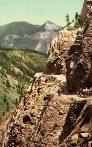
Ouray Toll Road, by Detroit Photographic Co., 1900.
The first road was built from Ouray across the steep “impassable” cliffs to Red Mountain Pass by the Ouray and San Juan Wagon Road Company in 1880 to reach the Red Mountain Mining District. Though progress was made in the first two years, the company ran out of money by 1882. After several attempts to reorganize and refinance, Otto Mears, known as the “Pathfinder of the San Juans” because he had built so many roads through the area, offered to purchase a 54% interest in the toll road company. After putting a larger and more experienced construction crew to work, much of the road was blasted from solid rock. His crews cleared 8.5 miles at a cost to Mears and his backers of $40,000 per mile. He also extended the road along Red Mountain Creek over Red Mountain Pass, down Mineral Creek, and into Silverton.
The road was completed in 1883, and the narrow track operated as a freight and stage line. Mears attempted to recoup his costs by charging a $5 toll for a team and wagon, $2.50 for a trail wagon, and $1 for saddle animals. Mears made sure the road narrowed at Bear Creek Falls, about three miles south of Ouray, to prevent anyone from circumventing his toll bridge. Here, his gatehouse doubled as a small store where he sold “whiskies and fine cigars.”
However, local merchants and miners who contributed money and labor toward completing the road soon turned on Mears. By 1887, San Juan County and the State overtook road maintenance, thus ending one man’s dominance of Red Mountain Pass.
Silverton Railroad, Red Mountain Pass, 1888.
But Otto Mears had other plans and worked to connect the Red Mountain Mining District to Silverton with the Silverton Railroad. In 1888, the line reached Ironton in November. It was completed in September 1889 to its terminus in Albany, about eight miles south of Ouray. Above this point, the toll road above Ironton was much too steep for the Silverton Railroad to use as a roadbed. An electric cog railway was planned to connect Ouray with Ironton, but it was never completed due to financial restraints.
The railroad connected the Red Mountain Mining District’s towns to the bustling city of Silverton and allowed the mines to ship medium and low-grade ore to smelters in Durango and Pueblo.
The first automobile descended the Red Mountain wagon road to Ouray in 1910 when Ouray doctor L.G. Crosby and some companions made the six-mile journey from Ouray to Ironton in a new Model T on a house call. This trip made immediate news, and Dr. Crosby and his passengers were hailed as heroes:

Million Dollar Highway in 1940, by Russell Lee.
“It was a trip that few believed could ever be accomplished. It was one of the most exhilarating, thrilling, unusual, and stirring automobile trips that could be taken or imagined.”
When the mines began to play out, the Silverton Railroad cut back service, shortened the line, and was abandoned in 1921. Mears’ toll road continued to operate until the early 1920s, when it was rebuilt and became part of US Highway 550.
In 1924, the Colorado Department of Highways improved Mears’ work and upgraded the road for automobile travel. Several changes were made at this time, but one of Mears’ most incredible feats – the 200-foot-long, 17-foot-wide Ouray Tunnel, remained the same. Today, its original integrity is still intact. Mears’ original course was extremely narrow outside of Ouray and closer to the Uncompahgre River than modern US 550. However, above Bear Creek Falls, US 550 still follows Mears’ initial shelf.
The 1930 State Highways map showed US 550 as a patchwork of a graded and surfaced road. Armed with improved snow-clearing machinery, the state opened the road year-round for the first time in 1935.
Many people traveling the byway wonder why some places have no guardrails. Archival photos show that large earthen blocks once served as guardrails in the road’s early days. However, the blocks left snowplow drivers no place to push the 300 inches of snow annually falling on the San Juans. There are some guardrails along the highway today, but it can still be maintained only where the road has enough width.
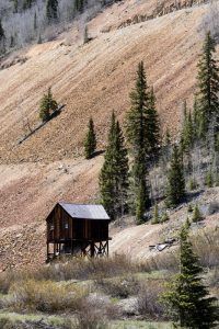
An old mining structure on the Million Dollar Highway by Carol Highsmith.
Today, U.S. 550 draws an average of 2,300 vehicles daily as travelers are drawn to the stunning alpine panoramas, wildlife views, and ghost towns along this historic path.
©Kathy Alexander updated January 2025.
Also See:
Durango – Railroad Town of the Southwest
Million Dollar Highway Photo Gallery
Ouray, Colorado – Switzerland of America
Silverton – High in the San Juans
Sources:
Colorado Department of Transportation
Narrow Gauge
Visit Durango
Wikipedia