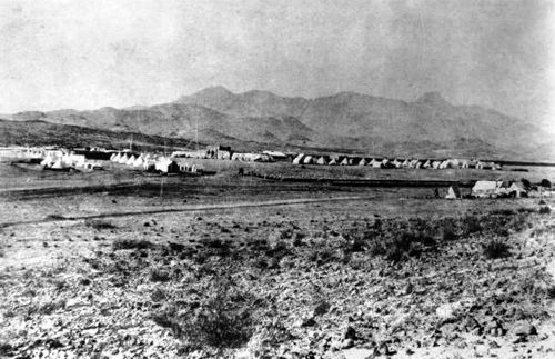
Fort Cummings, New Mexico, 1882.
First “discovered” in 1846 by a Mormon Battalion traveling from Santa Fe to California, Cooke’s Spring, in present-day Luna County, New Mexico, was named after the battalion’s commander and would later become the site of Fort Cummings.
After the spring was discovered, it and the nearby pass made it a popular overland route for travelers, but as such, it also made it a popular ambush site for the hostile Apache. The first fort was established by Captain Valentine Dresher, who halted his Company B, 1st Infantry, California Volunteers here on October 2, 1863, during the Civil War.
Choosing the site for a permanent fort, the building soon began, and over the next decade, a barracks, officers’ quarters, a hospital, and numerous other buildings were built, including a high adobe wall surrounding it. Later, Fort Cummings became a Regular Army garrison, protecting travelers on the overland route and a Butterfield Overland Mail station on the site between 1858 and 1861.
In September 1867, the fort was called home to the 38th U.S. Infantry of Buffalo Soldiers, which included the only female known to have ever been a part of the all-black regiments—Cathay Williams. During this time, the fort suffered a brief mutiny in December 1867 when a camp follower was expelled for stealing money.
Several expeditions and patrols set out from the fort, some as far as Mexico, but the soldiers made few contacts with the Indians.
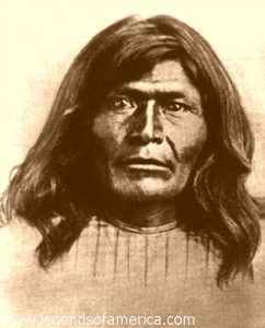
The fort was abandoned in 1873 and began to deteriorate under the elements. However, it was reoccupied in 1880 after a band of Warm Springs Apache under Victorio bolted from the San Carlos reservation and began terrorizing southern New Mexico and western Texas.
In 1886, one of the first test heliograph messages was relayed from Fort Cummings to Tubac, Arizona, and back over a distance of nearly 300 miles. A heliograph uses a mirror to reflect sunlight to a distant observer by moving the mirror and sending Morse code. It became a simple but highly effective instrument in the 19th century and continued to be used until about 1935.
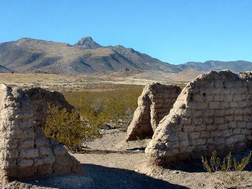
Today, little remains of Fort Cummings, but the crumbling remains of adobe walls and earthen mounds indicate where foundations once stood. Currently “maintained” by the Bureau of Land Management, the ruins are located about 20 miles northeast of present-day Deming, New Mexico.
To get there, take State Highway 26, about seven miles from Florida, New Mexico, then turn onto Cooke’s Canyon Road NE at mile marker 14 by the railroad water tank. After more than a mile on a gravel road, the path crosses a cattle guard and jogs left onto a distinct Jeep trail. After several more miles, the road crosses another cattle guard, and a plaque can be seen on the left and an old cemetery on the right. The ruins of Fort Cummings are about 500 yards to the north.
©Kathy Alexander/Legends of America, updated March 2025.
Also See:
Forts & Presidios Across America
Indian Wars of the Frontier West
Soldiers & Officers in Military History
See Sources.


