

Skyline Drive, Cañon City, Colorado, by Kathy Alexander.
Skyline Drive in Cañon City, Colorado, is a scenic, thrilling 2.6-mile road with unparalleled views of the area.

Skyline Drive today, Cañon City, Colorado by Kathy Alexander.
This one-way, narrow road follows the top of a high razorback ridge, with 450-foot drops on both sides in some places. It is not for timid drivers or those afraid of heights. But for those looking for a bit of adventure, its views of Cañon City and the Arkansas River Valley are awesome.
The idea for a road over the Hogback Hills West of Cañon City began in 1900, and before long, newspapers began carrying items about the proposed “Alta Vista Drive.”
It was soon decided that the road could be built by inmate labor from the Cañon City Territorial Prison, and a local committee was formed to raise money. The $2,000 raised was used to pay for the inmates’ tools and supplies to build the road.
“To visit it would prove especially attractive; indeed, we can almost see ourselves speeding along that mountain highway by moonlight.” – Cañon City Times

Skyline Drive, Cañon City, Colorado by George Beam, about 1920.
The single-lane road was built in 1905 by 60 inmates working under the direction of Warden John Cleghorn. The inmates got 10 days off their sentence for every 30 days worked.
In the Fall of 1905, a contest was held to name the road, and the Cañon City Record asked readers to submit ideas. Skyline Boulevard was selected; however, from the beginning, it was more often called Skyline Drive.
“Skyline Drive is about the most popular thing that ever happened. On Sundays, more than 200 vehicles and probably more than 1,000 people viewed the beauties of this rich valley.”
– Cañon City Record, February 1906
When the road was opened in 1906, the city council declared it unlawful for automobiles to use the road, reserving it for horse-drawn carriages, bicycles, and foot traffic. Cars were not allowed because they would scare the horses. However, after community protests, the council relented in 1907, allowing vehicles on Tuesday mornings and Friday afternoons. The Cañon City Record reported that the council had reservations about their decision because “horse and car conflicts have resulted in the narrow escape of toppling over the mountain.” In time, the automobile overtook the horse-and-buggy in popularity and the ordinance was eliminated.
The stunning drive, which gave residents and visitors 360-degree views, was soon featured in newspapers and magazines as far away as New York.
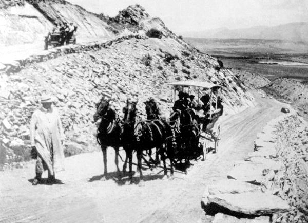
Tally Ho Tour Company on Skyline Drive, Cañon City, Colorado.
In 1910, local businessman Bill Garton launched the Tally Ho Tour Company, which ran trips over Skyline Drive in horse-drawn buggies. Using 14 teams of horses, the tour company picked up tourists at the major hotels and train depots, charging 25 cents per person for a ride along the scenic highway. Allen Bowen, another entrepreneur, once ran a snack shop in a small stone pavilion at the top of Skyline Drive.
In 1932, the stone arch at the entrance to Skyline Drive was built, once again utilizing inmate labor. The arch was built using a native stone from each of the 48 states in the union (Alaska and Hawaii did not gain statehood until 1959)
The most ambitious undertaking was the city’s construction of a 1,4000 seat amphitheater on the East side of the ridge in 1934. Prison inmates, using picks and shovels, dug a 200-foot area named Skyline Bowl. The amphitheater was dedicated on June 12, 1934, with an opera performance attended by over 700 people. Sadly, a violent storm washed the amphitheater away just a few years later, and it was never rebuilt.

The entrance to Skyline Drive was built in 1933, photo by Kathy Alexander.
In 1999, a paleontology student discovered dinosaur footprints along the ridgeline. Though visible for years, they weren’t visible to the untrained eye. The site is marked with interpretive signs.
The asphalt road is very narrow, includes steep sections, and has no protections or guardrails along parts of the route. There is no turning around if you change your mind.
The drive reaches the top of the ridge, where the landscape falls away hundreds of feet on both sides. Several pullouts offer views. Near the top, interpretive signs explain the dinosaur tracks embedded in the cliff face. The path follows the ridge before descending the other side via two switchbacks to a residential area. The residential street soon intersects with 5th Street, where signs point South toward U.S. 50 and “Historic Downtown Cañon City.”
The entrance to Skyline Drive is on the West edge of Cañon City off U.S. Highway 50.
©Kathy Alexander/Legends of America, updated October 2026.
“Are you sure our Ford F-150 is going to fit on this road? And no, I don’t want to look; just take pictures while I concentrate on not falling off the side.”
– Dave Alexander, Legends of America, 2018.

Skyline Drive, Cañon City, Colorado by W. Babberger, the early 1920s, courtesy Denver Public Library
Also See:
Sources: