
2nd Street in Raton, New Mexico, by Kathy Alexander.
Located in northeastern New Mexico on the border between New Mexico and Colorado, Raton (pronounced Rah-tone) is the county seat of Colfax County. The city sits at an elevation of 6,680 feet at the base of the fabled Raton Pass.
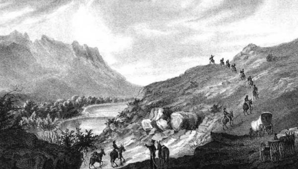
When the first Spanish explorers arrived in the area in the early 1700s, the Ute tribe lived in the mountains, and the Apache, Comanche, and Kiowa occupied the plains. When Mexico won her independence from Spain in 1821, William Becknell blazed the Mountain Branch of the Santa Fe Trail over Raton Pass. However, in these early days, the trail over the pass could only be traversed by pack animals, so trade moved mostly to the Cimarron Route of the trail.
At about the same time, numerous mountain men began to explore the southern Rocky and Sangre de Cristo Mountains in search of beaver pelts. These mountain men blazed many of the trails through the area that later became roads and led many early expeditions into the southwest. In 1841, the Beaubien-Miranda Land Grant was granted, giving Charles Beaubien and Guadalupe Miranda nearly two million acres in northeast New Mexico and southwest Colorado. Lucian Maxwell ultimately attained ownership of the land grant after marrying Charles Beaubien’s daughter. In the span of 20 years, Maxwell went from being a frontier hunter to being the largest individual landowner in the United States — owning 1,714,765 acres. In 1870, Maxwell sold almost all of his land, and over the years, the grant was broken up.
The Army of the West Travels into New Mexico.
In 1846, General Stephen Watts Kearny and his 1,600-man Army of the West made their way along the Mountain Branch of the Santa Fe Trail across Raton Pass and made improvements. Afterward, other wagons could utilize the route, increasing the number of people who passed through the Raton area.
In the early days of the Santa Fe Trail, a campsite called Willow Springs was developed. Shaded by two big willow trees with a spring that offered a refreshing drink, it was located at the mouth of what would later be called Railroad Canyon.
By 1860, the Majors, Waddell, & Russell Freight Company was hauling wagons over Raton Pass, and the same year, Willow Springs was designated as a government forage station site. The army soon built a corral and storehouse to store provisions for the military wagon trains coming through the area. The site also had good pasturage for livestock.
In 1865, Richens “Uncle Dick” Wootton built a 27-mile toll road over Raton Pass with a tollgate just north of the Colorado State line. Until Wootton improved the road, the route across the pass was in very bad condition, and it took five days to travel across.

Raton Pass, New Mexico
In 1866, Barlow & Sanderson’s Southern Overland Mail & Express Co. received the mail contract and started running stage service weekly between Kansas City, Missouri, and Santa Fe, New Mexico, along the Mountain Branch of the Santa Fe Trail. Home and swing stations were built, and the trip took 13 days. The stage line used Willow Springs as a water and emergency station. The same year, Charles Goodnight moved cattle over Raton Pass for the first time. However, because of the high cost of Wooton’s toll road, he moved the trail to the east, using Trinchera Pass for future cattle drives.
Sometime during the 1860s, a two-room jacal log house was built at the site. In 1871, it was taken over by Mr. Sears, who removed the old house and built a larger four-room log house that faced the spring. That same year, the land surrounding the house was taken over by a man named John Thacker, who established the Willow Springs Ranch with some 700 head of cattle. By 1874, the owner of Willow Springs Ranch was offering the water for sale to travelers for 25 cents per bucket, at which time, most people postponed their baths and other water needs until a cheaper water source could be obtained.
The spring water began to diminish at some point, and a 70-foot well was dug at Willow Springs. The Barlow & Sanderson stage line utilized Willow Springs as a watering place and emergency station. William Boggs then owned it. George J. Pace came to Willow Springs in early 1878 and rented part of the ranch house from Boggs, where he operated a store. That same year, a post office was established in the store, and George Pace became the postmaster.
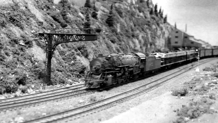
The railroad comes to New Mexico.
In the meantime, the Atchison, Topeka, and Santa Fe Railroad was building its line across Raton Pass. The first locomotive arrived in December 1878, and the first passenger train arrived in July 1879. The days of the Santa Fe Trail to that point then ended.
George J. Pace then moved his store and post office to nearby Otero in 1879 and moved them back to the new city of Raton in 1880. The town was named for the Raton Ridge, a geologic formation located north of the town, and the Raton Pass in the Sangre de Cristo Mountains, part of the Rocky Mountain chain.
By 1880, dozens of trains were running through Raton Pass to the fledgling city of Raton, and the railroad men boarded at William Boggs’ place at the former site of Willow Springs. The same year, railroad officials formed the New Mexico Townsite Company and purchased 320 acres from the Maxwell Land Grant Company. They soon began to lay out a townsite that took its name from the post office. Houses and business buildings were moved in from Otero. Before long, several new businesses were established, including the Raton Bank, Grant Central Restaurant, Five-Cent Beer Saloon, a boot and shoe shop, a grocery store, a dry goods store, merchandise stores, a barbershop, a photo studio, doctors, lawyers, and the Raton Guard newspaper, which encouraged conflict with the Maxwell Land Grant Company, which was working hard to evict squatters off their lands. In the summer of 1881, the settlement numbered 400 people, and the Raton Townsite was enlarged. In 1882, the railroad built a roundhouse and a boarding house for the railroad men, and the Raton Comet newspaper was established.
The rapid expansion of the railroad into Northern New Mexico fueled regional growth in raising sheep and cattle, and the Raton Caol Field was developed in the area. The railroad and coal mining combination in the early days brought an industrious character to the town, giving it the nickname of “Pittsburg of the West.”
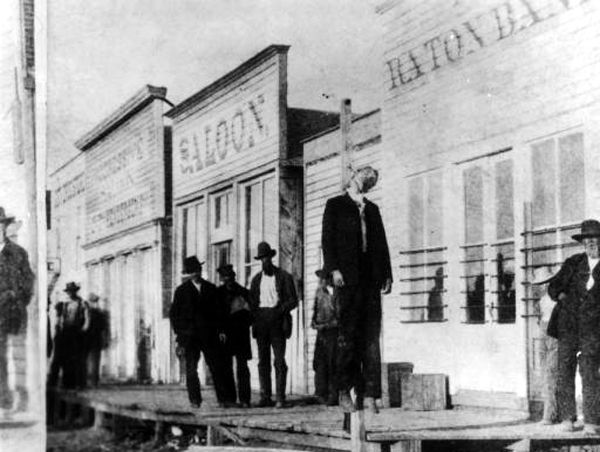
The hanging of Gus Mentzer, Raton, New Mexico
In February 1882, the Bank Exchange Bar was opened by William Burbridge in what is now the 100 block of South First Street. He had come to Raton in 1881 with a partner, Gus Mentzer, from Texas. But the young Mentzer was prone to gambling and excessive drinking, hurting business and causing trouble in the saloon. As a result, Burbridge finally dissolved the partnership and threw Mentzer out. Mentzer returned to the saloon on June 26, 1882, and asked Burbridge to take him back, but when Burbridge refused, all hell broke loose. Mentzer opened fire in the saloon and then ran away, wounding two men as he ran toward the depot and killing two men as he neared the train. Followed by an angry mob, Mentzer was hanged near the Raton Bank Building.
William Boggs, who was the last person to operate the Willow Springs site, stayed there until about 1885, when the buyers of the Maxwell Land Grant Company claimed ownership and kicked him off. In retaliation, a group of Anti-Granters put Boggs back in the house and, from the roof of a building, defied the deputies to come and try to kick him out again. The matter was dropped for a while, but finally, Boggs had to vacate. This was part of the Colfax County War, a dispute between the new owners of the Maxwell Land Grant and the many people who lived in the area. Afterward, Willow Springs changed hands many times and was absorbed by the town of Raton. The former Willow Springs site stood at present-day Maxwell Avenue and North Third Street.
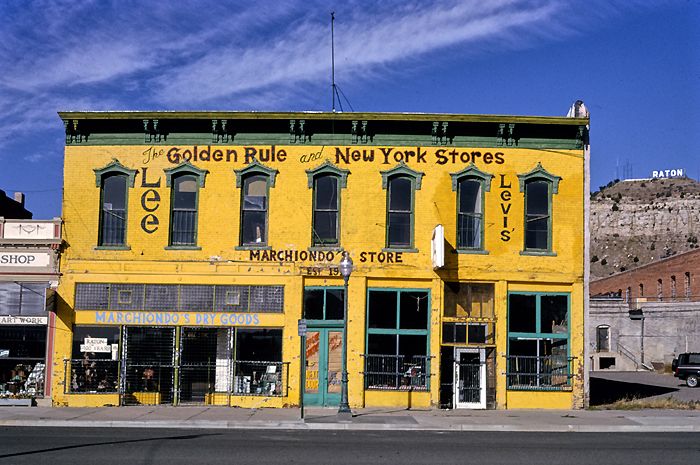
Marchiondo Building, Raton, New Mexico, by John Marjollies, 1991
During the 1880s, several buildings were built that continue to stand today. Some of these include Cook’s Hall, built in the late 1880s, located at 140-144 South First Street; the Marchiondo Building, which served as a store was constructed in 1882, located at 120-124 First Street; the Home Ranch Saloon at 132 North First Street was built in 1884; the A.H. Carey Hardware Store was established in 1882 and located at 112 North Second Street; and the Labadie House, built in 1880 is one of the oldest dwellings in town. It is located between 1st Street and 2nd Street across from Ripley Park.
A red-light district was active in Raton by the late 1880s and continued into the early 1900s. The district included several homes and businesses on First Street.
The town was officially organized in 1891, and in 1897, the Colfax County Seat was moved from Springer to Raton.
By the turn of the century, the town was surrounded by several coal mines, which employed more than 2,000 men. Some of these included the Koehler Mine, located about 22 miles to the southwest; the Van Houten Mine, located 16 miles southwest; the Gardiner Mine, three miles west of Raton; the Brilliant Mine, nine miles northwest; and the Sugarite Mine, seven miles northeast. By this time, Raton was called home to 3,540 people.

Raton, New Mexico Depot by Kathy Alexander.
It was during this prosperous period that many of Raton’s elegant buildings were built. Some of these include the Shuler Theater, built in 1913 as a combination city hall and municipal auditorium, located at 131 North Second Street; the Abourezk Building, built in 1906 for a drug store, located at 132 South First Street; the Raton Depot, located at 201 South First Street, and many others.
Coal mining flourished throughout the region until the decline of mining beginning in the 1960s.
Tourism in Raton began earnestly after World War II when La Mesa Racetrack was established in 1946. New Mexico’s first racetrack attracted numerous visitors for years until it closed in 1992.
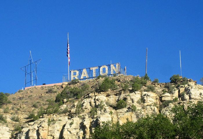
Goat Hill, Raton, New Mexico, courtesy Wikipedia.
After the closing of most of the coal mines in the area and the La Mesa Racetrack in 1992, the city entered into a period of relative decline that saw the loss of retail and hospitality jobs downtown.
Raton’s downtown area became a Registered Historic District in 1977. The district is bounded on the north by Clark Avenue and on the south by Rio Grande Avenue. On the east, the district is bounded by First Street, and on the west, the district is bounded by Third Street. The district covers about 200 acres and contains 95 significant buildings. A self-guided walking tour is available at the Raton Museum located at 108 South Second Street. The museum features exhibits related to Raton’s ranching, mining, Santa Fe Trail, and railroad history. Raton was designated as one of the first Arts and Cultural Districts in 2009, and since that time, many of the buildings have received upgrades.
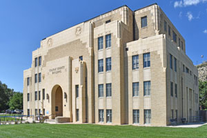
Colfax County Courthouse in Raton, New Mexico by Kathy Alexander.
More historic buildings can be found in the historic district, including the Palace Hotel, built in 1896 and located on the southwest corner of South First Street and Cook Avenue. An art gallery occupies the old Wells Fargo Express Company office at 145 South First Street, which was built in 1910. The former Swastika Hotel, located in a decorative six-story brick building, was built in about 1928 by the Swastika Coal Company. Located at 200 South 2nd Avenue, it has long been home to the International Bank. The train still runs by the historic Santa Fe Depot located at 201 South First Street, offering passenger service by Amtrak. First Street houses galleries, antique shops, gift shops, and cafes today.
Goat Hill, the home of the “Raton” sign, offers spectacular panoramic views of the area. It can be accessed by car, but a high-clearance vehicle is recommended.
Today, Raton is called home to about 6,103 people.
The city is located on the old Santa Fe Trail and is also part of the Dry Cimarron Scenic Byway.
Sugarite Canyon State Park is located 12 miles northeast of Raton, featuring the ruins of the old Sugarite coal mining town. The park also provides camping, fishing, and hiking to visitors. Capulin Mountain National Monument, a symmetrical volcanic cone rising 1,500 feet, lies 32 miles to the southeast.
©Kathy Alexander/Legends of America, updated February 2024.
Also See:

El Raton Theater, Raton, New Mexico, by Kathy Alexander.
Santa Fe Trail – Highway to the Southwest
Sources:
Colfax County
Pike, David; Roadside New Mexico: A Guide to Historic Markers, University of New Mexico Press, 2015
Raton Chamber of Commerce
Raton Historical Marker
Raton Main Street
Stanley, F.; Raton Chronicle, World Press Publishing, 1948