
Lewis and Clark
In 1804, Meriwether Lewis and William Clark began their famous journey of the West. While exploring Nebraska in their expedition, they closely followed the Missouri River in the state’s northeast corner. Nebraska celebrates the pair’s fabled journey along the Lewis & Clark Scenic Byway today.
The byway begins just south of Blair, Nebraska, and continues north along Highway 75 to South Sioux City for 67 miles. Highway 75 parallels the Missouri River, where a long history of Native Americans, trappers, and traders have left their historical marks.
Traveling along one of Nebraska’s most scenic routes, you will experience lakes, rivers, heavily wooded areas, river bluffs, two Indian Reservations, and some of Nebraska’s earliest settlements.
Though the scenic byway begins just south of Blair, you might want to begin your trip in Omaha, some 25 miles south of Blair, on Highway 75, and make your journey a fun and historically filled all-day trip.
In Omaha, you can see Fort Omaha, at 30th and Fort Streets, the army headquarters during the wars against the Plains Indians, and the home of General George Crook. You can also experience several museums, including the Durham Western Heritage Museum, the Great Plains Black History Museum, and the Joslyn Art Museum. Visit Lewis and Clark Landing to get a virtual taste of the city’s fine food and entertainment. Don’t forget that Omaha is home to Father Flannigan’s Boys Town, where Edward J. Flanagan started programs to help troubled children become responsible citizens. The village was made famous by the 1938 award-winning movie “Boys Town,” starring Spencer Tracy and Mickey Rooney. Lewis and Clark Landing.
Continuing north along Highway 75, you will soon see the signs pointing to Fort Atkinson State Historical Park just west of the scenic byway. At this site, Lewis and Clark met with Native Americans on the “Council Bluff” near the spot where Fort Atkinson was later located. Fort Atkinson was the first and largest military post west of the Missouri River, established in 1820 as a garrison for some 1,000 soldiers within its walls. Soon it became an essential gateway to the fur region of the Upper Missouri River and the Rocky Mountains. In 1827, the fort was abandoned so that the military could concentrate its efforts further south, with more traffic going west.
Next, you will see the Boyer Chute National Wildlife Refuge, which covers approximately 3200 acres west of the Missouri River. The refuge provides nature trails, picnic areas, biking, fishing, canoeing, and bird watching.
Five miles east of Blair on U.S. Highway 30, you can see another wildlife refuge — the DeSoto National Wildlife Refuge provides excellent sights of migrating ducks and geese. Lying in the Missouri River Valley, the refuge is also home to wildlife, including deer, cottontails, raccoons, coyotes, and fox squirrels.
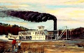
Steamboat
Various trails weave throughout the refuge to allow visitors to enjoy the plant and animal life. In addition to these natural features, you can see the hull of the 178-foot Bertrand steamboat that lies buried in a pond and 200,000 cargo artifacts from the 1865-era steamboat. The Bertrand sternwheeler sank in the Missouri River on its way to deliver mining supplies to Montana in 1865. Fishing and boating are also available. Black Elk/Neihardt Park, Home of The Four Winds, can be seen in Blair commemorating two great men – Black Elk, a Lakota Sioux Indian chief, and John G. Neihardt.
The park includes many reminders of the vision of Black Elk, the most prominent being the Tower of Four Winds. This tower stands 45 feet high and includes a tall cross featuring a mosaic of approximately 50,000 pieces. The large mosaic features a messiah figure with outstretched arms, while smaller mosaics are throughout the park. This monument is a reminder of Black Elk’s vision of peace and unity for all people. The park is located at College Drive and 32nd Street in Blair.
Continuing onto Tekamah, you can see many historic sites in the town, such as the Tekamah City Bridge, John Henry Stork Log House, the E. C. Houston House, and the Spielman house owned by Delmar and Elaine Chamberlain. The Burt County Museum is located in the E.C. Houston House.
You can visit a one-room schoolhouse and a 1908 house on the museum grounds. The Pelican Point Recreation Area and Summit Lake State Recreation area provide recreation opportunities for visitors and locals alike. Pelican Point State Recreation Area has a boat ramp to access the Missouri River. Picnic areas, fishing opportunities, and camping facilities are available. Summit Lake State Recreation Area provides camping, hiking, boating, fishing, swimming, and picnicking opportunities.
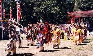
The Winnebago Pow Wow
The Omaha Indian Reservation is located along the byway north of Tekamah. According to oral tradition, the Missouri River was where this tribe first settled, and they have remained in the area for over 400 years. A Harvest Festival Pow Wow is held every August in Macy.
The Winnebago Indian Reservation west of Winnebago is home to an Annual Homecoming Pow Wow held each July that celebrates the homecoming of its last great war chief, Little Priest, and 75 of his warriors.
The Pow Wow sports colorful clothing and beautiful singing and dancing in celebration of Little Priest, imprisoned in South Dakota with his warriors after the Winnebago tribe had been uprooted from their Minnesota home and forced to live in South Dakota and then later in Nebraska. Today, the tribe promotes tourism and has developed a large bison herd and visitors center where visitors can learn the cultural importance of bison to the Plains tribal culture.
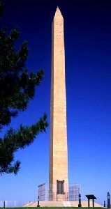
The Sergeant Floyd Monument
Sergeant Floyd Monument Park is located just before entering South Sioux City and commemorates Sergeant Charles Floyd, a volunteer engineer, and U.S. soldier on the Lewis and Clark Expedition. Floyd had joined the Army in Kentucky in 1803 and accompanied the expedition through Council Bluffs, where they met with local Indian chiefs. In August, Floyd became ill with what many believe was a ruptured appendix. He died on August 20, 1804, and his grave was marked with a cedar post engraved with his name and date of death. Because his grave was located near the Missouri River, erosion caused much of his grave to be washed down the river.
Citizens of the area preserved many of the bones and placed his grave 200 yards east of the original burial site. The 100-foot-high obelisk monument was completed in 1901 and registered as the first National Historic Landmark in 1960. Floyd was the only U.S. soldier to die on the Lewis and Clark Expedition.
South Sioux City was once known as the “wildest little town on the Missouri” during Frontier Days. Today the city features a metropolitan area but still maintains the friendly feel of a small rural town. Crystal Cove, along the Missouri River, has a boat ramp for fishing boats, a swimming beach, a picnic area, and a paved walking trail. Several historic buildings are located in the city, including the Meisch House, built in 1888, which is an example of the “square” or “cubic” house. The Emmanuel Lutheran Church was the first Lutheran Church built in the Nebraska Territory. The O’Connor House is a historic two-story brick home built by Captain Cornelius O’Connor for his wife and eight children.
Though the Lewis & Clark Scenic Byway ends at South Sioux City, if you haven’t had enough scenic views, you can check out the Outlaw Trail Byway, which begins here and travels through the “Old West” to Valentine along Nebraska Highway 12.
Enjoy your trip along the Lewis & Clark Scenic Byway, where you can share the path where trappers, traders, and American Indians once lived and traveled.
Scenic Attractions:
DeSoto National Wildlife Refuge – The DeSoto National Wildlife Refuge provides excellent sights of wildlife as well as the hull of the Bertrand steamboat that lies buried in a pond and 200,000 cargo artifacts from the 1865-era steamboat. 1434 316th Lane, Missouri Valley, Iowa 51555, 712-642-4121.
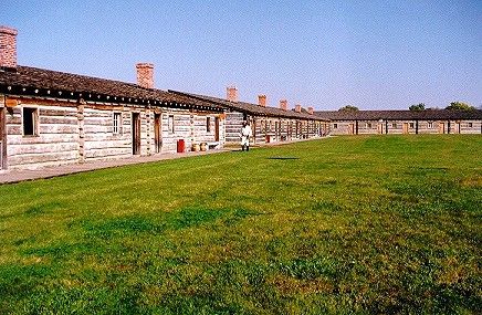
Fort Atkinson, Nebraska
Fort Atkinson State Historical Park – Fort Atkinson was the first and largest military post west of the Missouri River, established in 1820 as a garrison for some 1,000 soldiers within its walls. Volga River State Recreation Area, 10225 Ivy Road, Fayette, Iowa 52142, 563-425-4161.
Fort Omaha – Fort Omaha was the army headquarters during the wars against the Plains Indians and the home of General George Crook. Located at 30th and Fort Streets in Omaha, Nebraska. Run by the Douglas County Historical Society, 5730 N. 30 St, #11B, Omaha, Nebraska 68111-1657. General Crook House Museum Phone – 402-455-9990
Boyer Chute National Wildlife Refuge – Boyer Chute National Wildlife Refuge is a satellite refuge of DeSoto National Wildlife Refuge. The refuge opened in 1996. It is a joint federal and local conservation partners to restore a portion of the Missouri River habitat that flows through a two-mile-long channel paralleling the river’s main flow. The site, consisting of about 3,200 acres, is located on the west side of the Missouri River, 3 miles east of Fort Calhoun, Nebraska. Located 8 miles north of Omaha, it attracts visitors throughout the Omaha/Council Bluffs metropolitan area. Boyer Chute National Wildlife Refuge, P.O. Box 69, Fort Calhoun, NE 68023, 402-468-4313.
Burt County Museum – Includes The E.C. Houston House, C.D. Houston House, the Nolana one-room schoolhouse, and the surrounding grounds offer visitors a historic and charming glimpse into the rich heritage of the Burt County Area. Free admission and donations are appreciated. Hours: Open 1-5 p.m. Tues., Thurs., and Sat. or by appointment for larger groups. Located on Highway 75 at 319 North 13th Street, Tekamah, Nebraska. (402) 374-1505
Lewis & Clark Interpretive Center – From the moment you arrive on the grounds of the Lewis & Clark Interpretive Center in Sioux City, you’ll begin your journey back in time…back to the days when the Corps of Discovery made its historic journey up the Missouri River, traveling past present-day Sioux City. Interstate 29, Exit #149, Hamilton Boulevard, Larson Park Rd, Sioux City, Nebraska
Sergeant Floyd Monument – This 100-foot high stone obelisk memorializes Sergeant Charles Floyd, who died on the 1804 Lewis and Clark Expedition. Overlooking a breathtaking view of the Missouri River on Highway 75 near Glenn Avenue, it is the first historic landmark registered by the U.S. Government in 1960. U.S. Highway 75 & Glenn Ave, Sioux City, Nebraska
Sergeant Floyd Welcome Center & Museum – This dry-docked former Missouri River inspection ship now houses a museum, gift shop, and information center. Exit 149 off I-29 to South Larsen Park Road. Winter hours, Daily 9 am-5 pm. Free admission. 712-279-0198, Interstate 29, Exit #149, Hamilton Boulevard, Larson Park Rd, Sioux City, Nebraska
Sioux City Art Center – This breathtaking 45,000 square-foot facility houses a three-story glass atrium, six exhibition galleries to house traveling exhibits, and a permanent collection gallery for the Center’s 900-piece collection. 225 Nebraska St, Downtown Sioux City, Nebraska, 712-279-6272.
Sioux City Public Museum – The Museum’s exhibits include Sioux City history and Indian artifacts. 2901 Jackson St, Sioux City, Nebraska, 712-279-6174.
© Kathy Alexander/Legends of America, updated March 2023.
Also See:
Corps of Discovery – The Lewis & Clark Expedition
Nebraska – The Cornhusker State
William Clark – Co-Leader of the Corps of Discovery Expedition